지질해양학 (Marine Geology)contents.kocw.net/KOCW/document/2015/inha/hahokyung/12.pdf ·...
17
1 지질해양학 (Marine Geology) 담당교수: 하호경 ([email protected]) • 수심측량(bathymetry): bathy: deep; meter: measure Photographed in Histoire de la Marine française illustrée, Larousse, 1934.
Transcript of 지질해양학 (Marine Geology)contents.kocw.net/KOCW/document/2015/inha/hahokyung/12.pdf ·...

1
지질해양학 (Marine Geology)담당교수:하호경 ([email protected])
• 수심측량(bathymetry): bathy: deep; meter: measure
Photographed in Histoire de la Marine française illustrée, Larousse, 1934.
2
수심측정
• 챌린저호보고서(Challenger Report, 1880).
• 증기기중기는수심을알아보기위해줄의끝에무거운추를달아바닥에내리는데사용하였다.
• 492곳의수심측정, 중앙대서양산맥을확인
• 초기수심측정방법?–돌던지기/추달기
• 최근첨단관측방법– Echo sounding– Multi-beam Systems– Satellite Altimetry
수심측정

3
시추기록
• 세계기록: 1994년 12.262 km 시추 (러시아의콜라반도)
• JOIDES Resolution: 수심 2.5 km깊이에서 2 km굴착성공 (1991년)
• 일본의새시추선 Chikyu 7 km까지가능
다중음향시스템(Multi-beam Systems)
Multi-beam systems provide more accurate measurements than echo sounders. Multi-beam systems collect data from up to 121 beams to measure the contours of the ocean floor.

4
우리나라예
위성(satellite)을이용하다Satellite altimetry measures the sea surface height from orbit. Satellites can bounce 1,000 pulses of radar energy off the ocean surface every second.
1985-1990년까지 미해군에서운용한 Geosat위성이궤도에서해면의높이를측정하였다. 7 km/s로이동하면서매초수천번의레이더신호를송수신하면서고도(정확도: 0.03 m)를측정하였다. 해저에솟아있는지형은주변보다중력이커서주위의물을끌어당겨수면의굴곡이생기게된다.
Jason

5
6
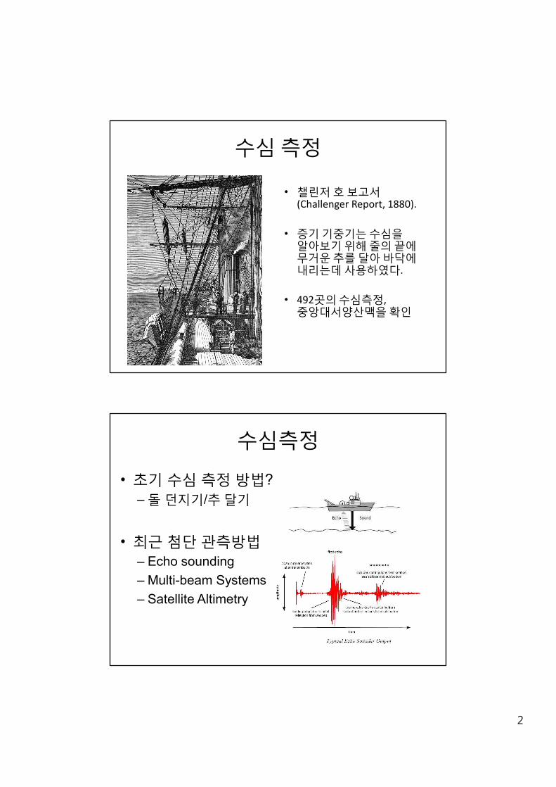
기원에따른퇴적물의분류
고위도에규조연니(Siliceous oozes)가풍부
해양퇴적물의분포도

7
In contrast of carbonate, the dissolution rate of silica decreases with depth.
Most rapid dissolution occurs in surface water. If skeletal remains with silica (e.g. diatoms) can reach the bottom, they can be preserved.
Dead diatoms sink slowly, fecal pellets sink quickly.
Preservation of siliceous sediments in the deep ocean reflects the biologic fertility of overlying surface waters.
규조연니 (Siliceous oozes)
Mainly from skeletal remains of:
1) Diatoms
2) Radiolarian
해양으로퇴적물의공급
1) 하천 (Fluvial Inputs)--Rivers Discharge Sediment into the Ocean
2) 바람 (Aeolian Inputs)--Winds carry sediments from the continents into the ocean.
3) 생물 (Biological Inputs)--Marine organisms die and sink to the bottom.
4) 자생 (Authigenic Inputs)--Sediments that are formed in the oceans. Mainly metal rich materials near hydrothermal vents.
8
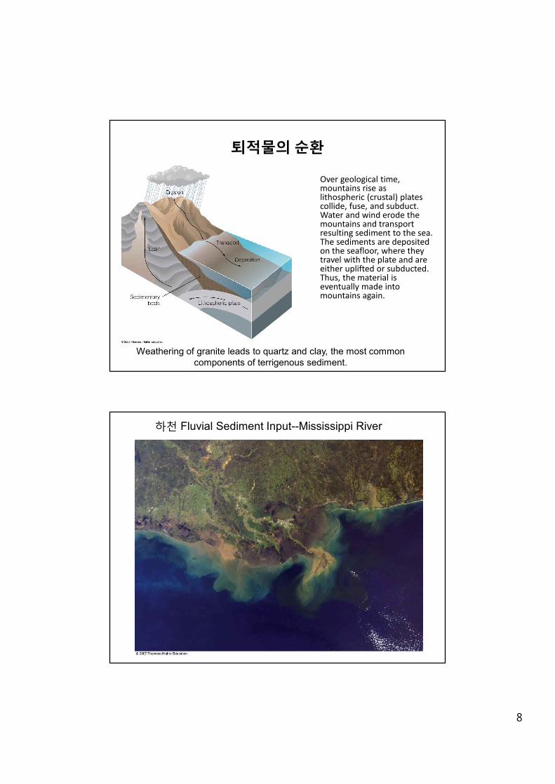
Over geological time, mountains rise as lithospheric (crustal) plates collide, fuse, and subduct. Water and wind erode the mountains and transport resulting sediment to the sea. The sediments are deposited on the seafloor, where they travel with the plate and are either uplifted or subducted. Thus, the material is eventually made into mountains again.
퇴적물의순환
Weathering of granite leads to quartz and clay, the most common components of terrigenous sediment.
하천 Fluvial Sediment Input--Mississippi River
9
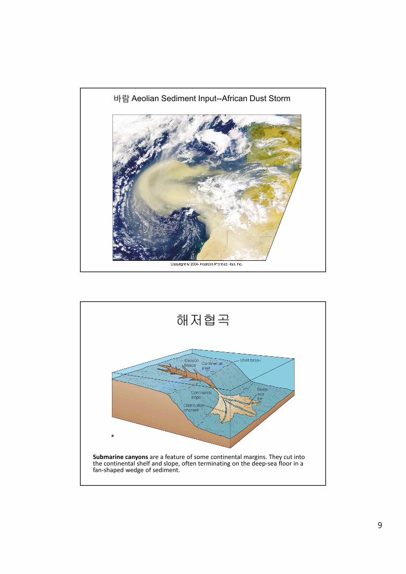
바람 Aeolian Sediment Input--African Dust Storm
해저협곡
Submarine canyons are a feature of some continental margins. They cut into the continental shelf and slope, often terminating on the deep-sea floor in a fan-shaped wedge of sediment.

10
저탁류의발생(right) 자메이카섬에서발생한저탁류(turbidity current). 저탁류는물의흐름이아니라중력에의해발생한다.
Avalanche-like sediment movement caused when turbulence mixes sediments into water above a sloping bottom are called turbidity currents.
이동속도계산: 해저케이블파손
Turbidity currents can transport terrigenous sediment down the continental slope.
Graded beds, called turbidites.

11
Hydrothermal Vents
Hydrothermal vents are sites where superheated water containing dissolved minerals and gases escapes through fissures, or vents. Cool water (blue arrows) is heated as it descends toward the hot magma chamber, leaching sulfur, iron, copper, zinc, and other materials from the surrounding rocks. The heated water (red arrows) returning to the surface carries these elements upward, discharging them at hydrothermal springs on the seafloor.

12
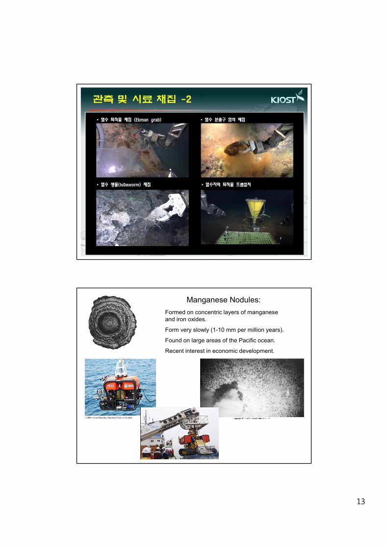
Hydrogenous (authigenic) Sediments:
Hydrogenous sediments precipitate directly from seawater.
Their formation is poorly understood, but it is thought to be associated with hydrothermal vent systems and mid-ocean ridge systems.
Most common hydrogenous sediments are manganese nodules.
Include evaporites and oolites.
Photo: S.J. Ju (KIOST)
13
Manganese Nodules:Formed on concentric layers of manganese and iron oxides.
Form very slowly (1-10 mm per million years).
Found on large areas of the Pacific ocean.
Recent interest in economic development.

14
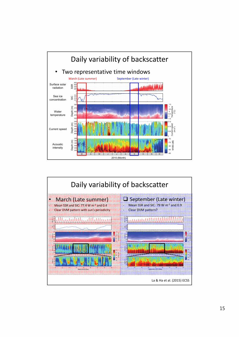
Deep scattering layer (DSL)Diel vertical migration
• Organisms within the deep scattering layer undertake a daily migration to hide in deep, darker waters during daytime
Materials and Methods
q Environmental data• Surface Solar Radiation (SSR, W m-
2) from NCEP
• Sea ice concentration (SIC) from ECMWF
• Water temperature and CDW thickness (m, 0°C isotherm) from MicroCats.
• Phytoplankton biomass (Chl-a, mg m-3) from MODIS.
q ADCP data (RDI, 150-kHz Workhorse)• Burst rate and interval : 5 pings ensemble/15 min, 8-m from 250 to 540 m
• Acoustic intensity (mean volume backscattering strength, MVBS) and current speed
• The main depth of sound scattering layer (DMVBS, m)
La & Ha et al. (2015) ECSS
15
Daily variability of backscatter
2010 (Month)
Dep
th (m
)
250300350400450500
MV
BS
(dB
)
−90
−85
−80
−75
−70
Dep
th (m
)
250300350400450500
Cur
rent
spe
ed (m
s )
0
0.05
0.10
0.15
Dep
th (m
)
320
370
420
470
520
Tem
pera
ture
(o
-1C
)
−1.5−1 −0.5
0 0.5 1 1.5
SIC
00.20.40.60.8
1
SSR
(W m
−2)(a)
(b)
(c)
(d)
(e)
0200400600800
Fig.5Fig.4
M A M J J A S O N D
SIC
Dep
th (m
)SS
RD
epth
(m)
Dep
th (m
)
2010 (Month)2010 (Month)
Dep
th (m
)
250300350400450500
MV
BS (d
B)
−90
−85
−80
−75
−70
Dep
th (m
)
250300350400450500
Cur
rent
spe
ed (m
s )
0
0.05
0.10
0.15
Dep
th (m
)
320
370
420
470
520
Tem
pera
ture
(o
-1C
)
−1.5−1 −0.5
0 0.5 1 1.5
SIC
00.20.40.60.8
1
SSR
(W m
−2)(a)
(b)
(c)
(d)
(e)
0200400600800
Fig.5Fig.4
M A M J J A S O N D
MV
BS
(dB
)C
urre
nt s
peed
(m
s-1
)Te
mpe
ratu
re( °
C)
March (Late summer) September (Late winter)
• Two representative time windows
Surface solar radiation
Sea ice concentration
Water temperature
Current speed
Acousticintensity
March 2010 (Day)
01 02 03 04 05 06 07 08 09 10 11 12 13 14 15 16 17 18 19 20 21 22 23 24 25 26 27 28 29 30 31 01
Dep
th (m
)
250300350400450500
Dep
th (m
)
250300350400450500
Dep
th (m
)
250300350400450500
Dep
th (m
)
320
370
420
470
520
SIC
00.20.40.60.8
1(b)
(c)
(d)
(e)
(f)
SS
R (W
m−2
)(a)
−90
−85
−80
−75
−70
−1.5−1 −0.5
0 0.5 1 1.5
11 12 13 14 15 16 17 18 19
MV
BS
(dB
)Te
mpe
ratu
re (
o C)
0100
200
300
Cur
rent
spe
ed (m
s )
0
0.05
0.10
0.15 -1
01 02 03 04 05 06 07 08 09 10 11 12 13 14 15 16 17 18 19 20 21 22 23 24 25 26 27 28 29 30 01
13 14 15 16 17 18 19 20 21
250300
350400450500
250300350400450500
250300350400450500
320
370
420
470
520
00.20.40.60.8
1
−90
−85
−80
−75
−70
−1.5−1 −0.5
0 0.5 1 1.5
September 2010 (Day)
MV
BS
(dB
)Te
mpe
ratu
re (
o C)
Dep
th (m
)D
epth
(m)
Dep
th (m
)D
epth
(m)
SIC
(b)
(c)
(d)
(e)
(f)
SS
R (W
m−2
)(a)
0100
200
300
Cur
rent
spe
ed (m
s )
0
0.05
0.10
0.15 -1
March 2010 (Day)
01 02 03 04 05 06 07 08 09 10 11 12 13 14 15 16 17 18 19 20 21 22 23 24 25 26 27 28 29 30 31 01
Dep
th (m
)
250300350400450500
Dep
th (m
)
250300350400450500
Dep
th (m
)
250300350400450500
Dep
th (m
)
320
370
420
470
520
SIC
00.20.40.60.8
1(b)
(c)
(d)
(e)
(f)
SS
R (W
m−2
)(a)
−90
−85
−80
−75
−70
−1.5−1 −0.5
0 0.5 1 1.5
11 12 13 14 15 16 17 18 19
MV
BS
(dB
)Te
mpe
ratu
re (
o C)
0100
200
300
Cur
rent
spe
ed (m
s )
0
0.05
0.10
0.15 -1
01 02 03 04 05 06 07 08 09 10 11 12 13 14 15 16 17 18 19 20 21 22 23 24 25 26 27 28 29 30 01
13 14 15 16 17 18 19 20 21
250300
350400450500
250300350400450500
250300350400450500
320
370
420
470
520
00.20.40.60.8
1
−90
−85
−80
−75
−70
−1.5−1 −0.5
0 0.5 1 1.5
September 2010 (Day)
MV
BS
(dB
)Te
mpe
ratu
re (
o C)
Dep
th (
m)
Dep
th (
m)
Dep
th (
m)
Dep
th (
m)
SIC
(b)
(c)
(d)
(e)
(f)
SS
R (W
m−2
)(a)
0100
200
300
Cur
rent
spe
ed (
m s
)
0
0.05
0.10
0.15 -1
Daily variability of backscatter
• March (Late summer)- Mean SSR and SIC: 77.4 W m-2 and 0.4- Clear DVM pattern with sun’s periodicity
q September (Late winter)- Mean SSR and SIC: 79 W m-2 and 0.9- Clear DVM pattern?
La & Ha et al. (2015) ECSS
16
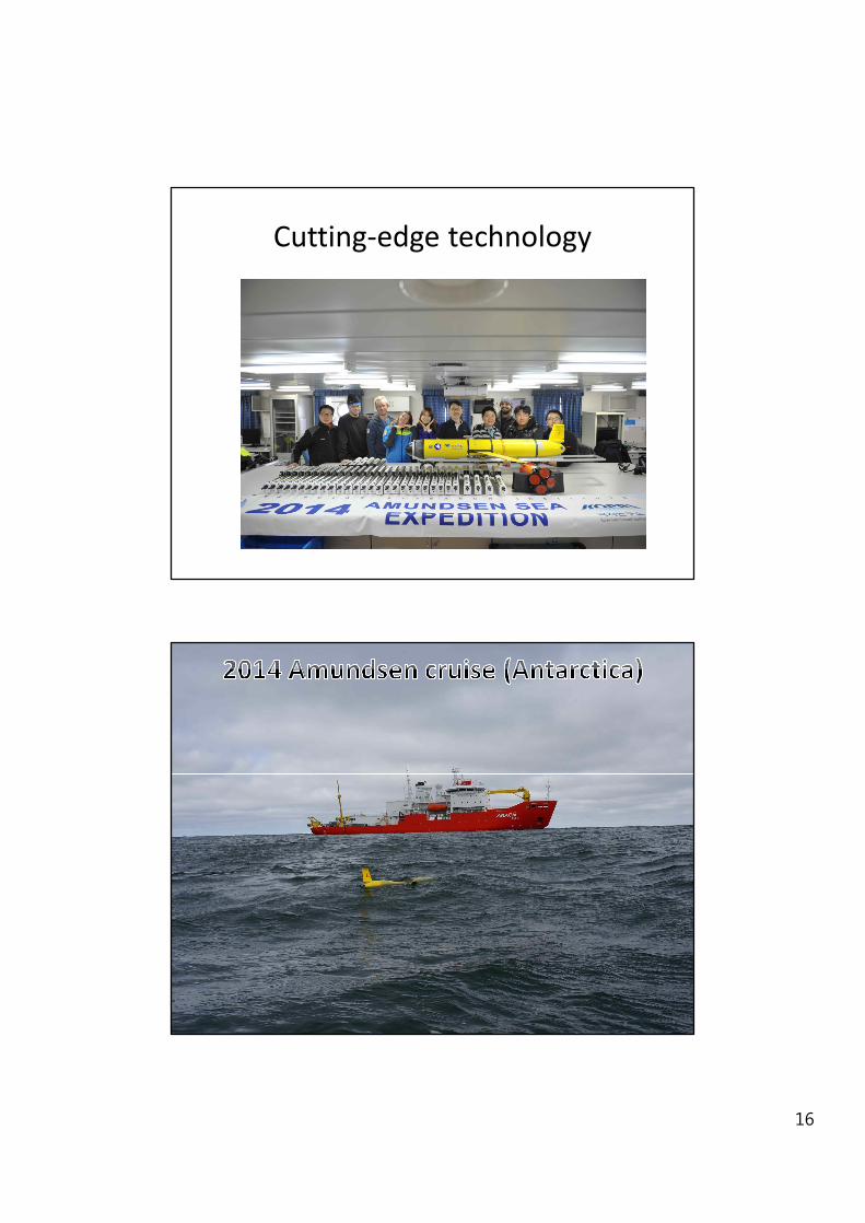
Cutting-edge technology

17
Leg 1 Leg 2 Leg 3 Leg 4
East South West North
Tem
pera
ture
(o C)
Salin
ity (P
SU)
A)
B)
Surface Water > -0.5C
Mid-depth <-1.5 C
Modified CDW bottom water ~ 0 C or higher
Western FlankOutflow region
Air France flight 447 from Rio de Janeiro to Paris crashed several hundred miles off the northeastern coast of Brazil. On April 4, 2011, a search team led by the Woods Hole Oceanographic Institution (WHOI) located the wreckage of the Airbus jet some 3,900 meters (nearly 2.5 miles) below the surface of the Atlantic Ocean.