
ANEXO Nº 2 - Mapas y Coordenadas
14
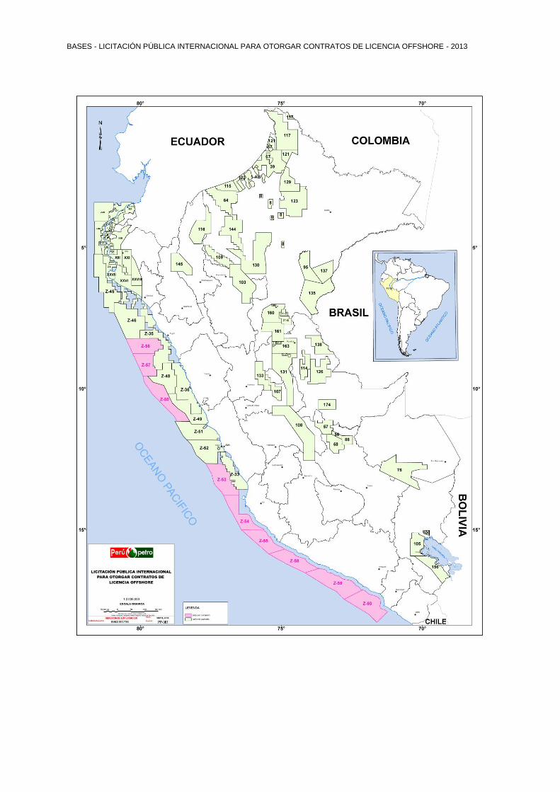
BASES - LICITACIÓN PÚBLICA INTERNACIONAL PARA OTORGAR CONTRATOS DE LICENCIA OFFSHORE - 2013 ANEXO Nº 2 MAPAS Y COORDENADAS DE LOS LOTES DISPONIBLES PARA LA LICITACION PÚBLICA INTERNACIONAL OFFSHORE 2013
-
Upload
truongkhanh -
Category
Documents
-
view
224 -
download
0
Transcript of ANEXO Nº 2 - Mapas y Coordenadas
BASES - LICITACIÓN PÚBLICA INTERNACIONAL PARA OTORGAR CONTRATOS DE LICENCIA OFFSHORE - 2013
ANEXO Nº 2
MAPAS Y COORDENADAS DE LOS LOTES DISPONIBLES PARA LA LICITACION PÚBLICA INTERNACIONAL
OFFSHORE 2013
BASES - LICITACIÓN PÚBLICA INTERNACIONAL PARA OTORGAR CONTRATOS DE LICENCIA OFFSHORE - 2013
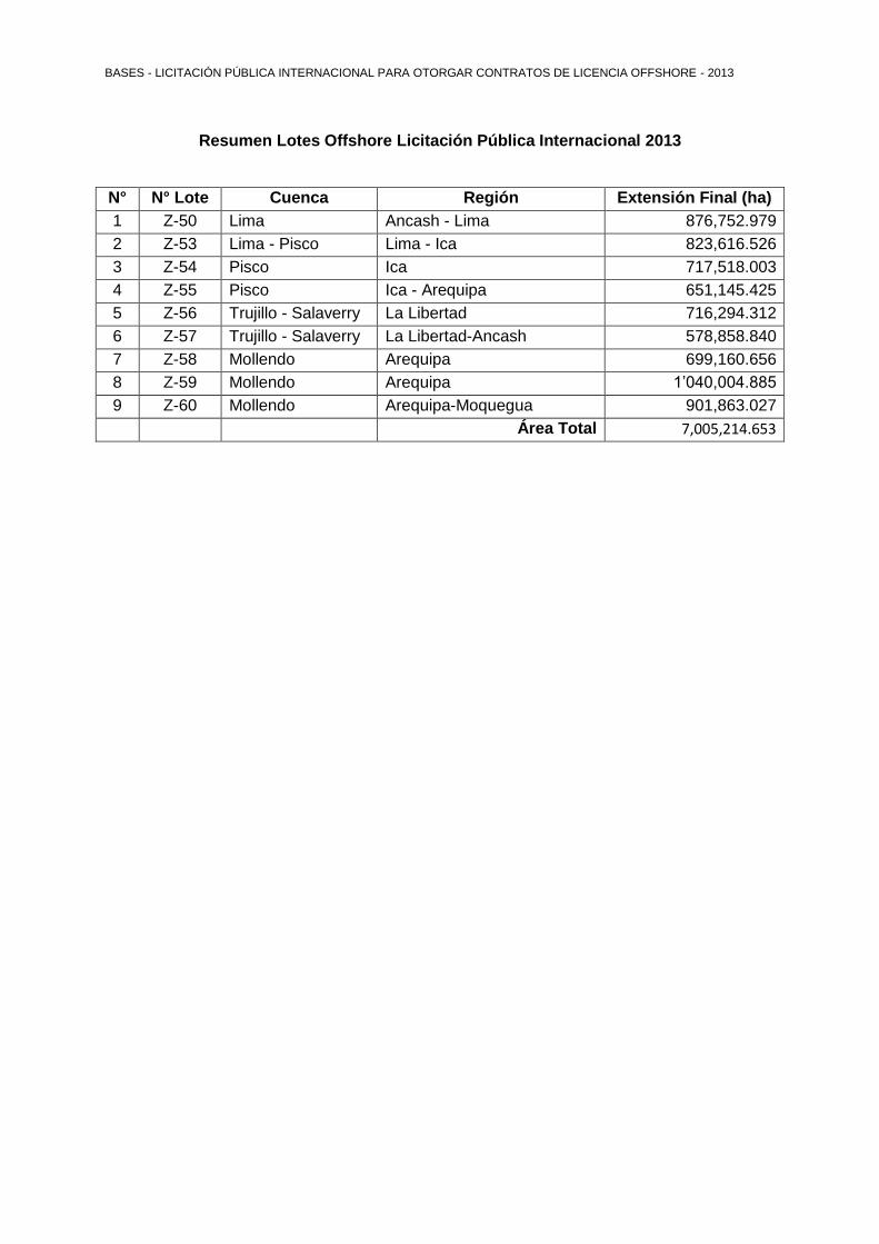
Resumen Lotes Offshore Licitación Pública Internacional 2013
N° N° Lote Cuenca Región Extensión Final (ha)
1 Z-50 Lima Ancash - Lima 876,752.979
2 Z-53 Lima - Pisco Lima - Ica 823,616.526
3 Z-54 Pisco Ica 717,518.003
4 Z-55 Pisco Ica - Arequipa 651,145.425
5 Z-56 Trujillo - Salaverry La Libertad 716,294.312
6 Z-57 Trujillo - Salaverry La Libertad-Ancash 578,858.840
7 Z-58 Mollendo Arequipa 699,160.656
8 Z-59 Mollendo Arequipa 1’040,004.885
9 Z-60 Mollendo Arequipa-Moquegua 901,863.027
Área Total 7,005,214.653
BASES - LICITACIÓN PÚBLICA INTERNACIONAL PARA OTORGAR CONTRATOS DE LICENCIA OFFSHORE - 2013

BASES - LICITACIÓN PÚBLICA INTERNACIONAL PARA OTORGAR CONTRATOS DE LICENCIA OFFSHORE - 2013
Anexo 2-1
Lote Z-50, Cuenca Lima
Coordenadas Lote Z-50
Coordenadas Planas U.T.M. Coordenadas Geográficas
Punto Metros Este Metros Norte Latitud Sur Longitud Oeste
1 619,981.474 8’942,912.997 09°33’40”288 79°54’24”234
2 637,456.473 8’942,912.997 09°33’38”353 79°44’51”088
3 658,889.737 8’919,243.785 09°46’26”070 79°33’04”872
4 700,329.655 8’906,578.065 09°53’11”720 79°10’22”884
5 733,305.582 8’836,767.629 10°30’56”812 78°52’05”614
6 756,099.857 8’814,535.963 10°42’54”767 78°39’30”725
7 782,465.618 8’795,776.748 10°52’58”065 78°24’58”289
8 803,725.786 8’765,094.947 11°09’29”720 78°13’09”363
9 751,253.780 8’765,094.947 11°09’44”378 78°41’57”740
10 739,442.858 8’786,121.655 10°58’23”207 78°48’31”957
11 654,096.404 8’874,145.913 10°10’54”695 79°35’35”871
12 623,646.040 8’919,807.461 09°46’12”099 79°52’21”537
BASES - LICITACIÓN PÚBLICA INTERNACIONAL PARA OTORGAR CONTRATOS DE LICENCIA OFFSHORE - 2013
Datum Coordenadas: WGS 84 Zona: 17 Extensión: 876,752.979 ha Cuenca: Lima Región: Ancash y Lima
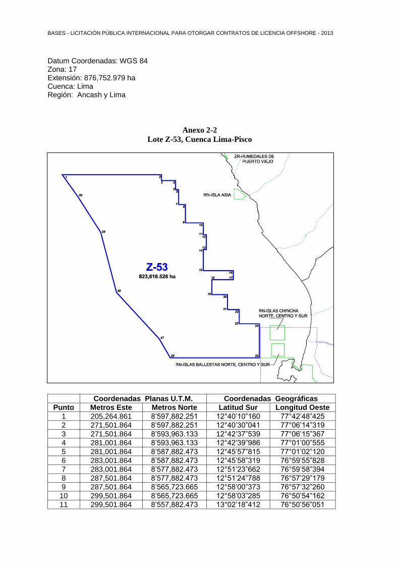
Anexo 2-2
Lote Z-53, Cuenca Lima-Pisco
Coordenadas Lote Z-53
Coordenadas Planas U.T.M. Coordenadas Geográficas
Punto Metros Este Metros Norte Latitud Sur Longitud Oeste
1 205,264.861 8’597,882.251 12°40’10”160 77°42’48”425
2 271,501.864 8’597,882.251 12°40’30”041 77°06’14”319
3 271,501.864 8’593,963.133 12°42’37”539 77°06’15”367
4 281,001.864 8’593,963.133 12°42’39”986 77°01’00”555
5 281,001.864 8’587,882.473 12°45’57”815 77°01’02”120
6 283,001.864 8’587,882.473 12°45’58”319 76°59’55”828
7 283,001.864 8’577,882.473 12°51’23”662 76°59’58”394
8 287,501.864 8’577,882.473 12°51’24”788 76°57’29”179
9 287,501.864 8’565,723.665 12°58’00”373 76°57’32”260
10 299,501.864 8’565,723.665 12°58’03”285 76°50’54”162
11 299,501.864 8’557,882.473 13°02’18”412 76°50’56”051
BASES - LICITACIÓN PÚBLICA INTERNACIONAL PARA OTORGAR CONTRATOS DE LICENCIA OFFSHORE - 2013
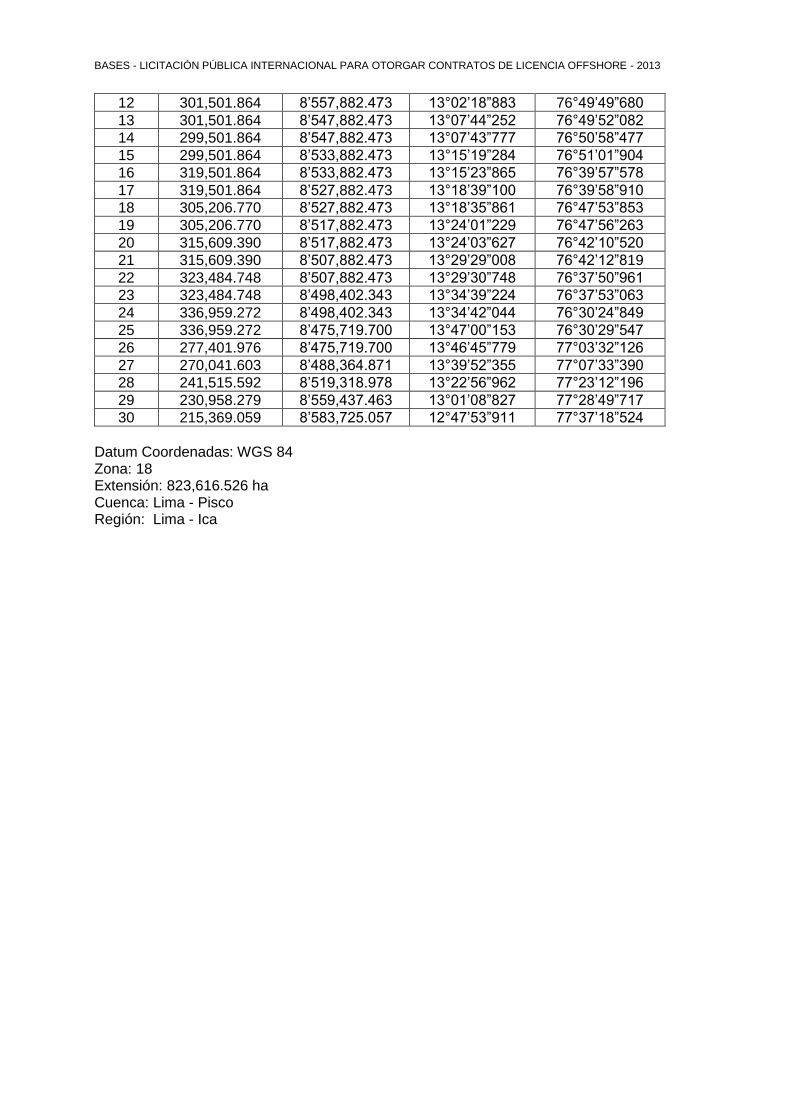
12 301,501.864 8’557,882.473 13°02’18”883 76°49’49”680
13 301,501.864 8’547,882.473 13°07’44”252 76°49’52”082
14 299,501.864 8’547,882.473 13°07’43”777 76°50’58”477
15 299,501.864 8’533,882.473 13°15’19”284 76°51’01”904
16 319,501.864 8’533,882.473 13°15’23”865 76°39’57”578
17 319,501.864 8’527,882.473 13°18’39”100 76°39’58”910
18 305,206.770 8’527,882.473 13°18’35”861 76°47’53”853
19 305,206.770 8’517,882.473 13°24’01”229 76°47’56”263
20 315,609.390 8’517,882.473 13°24’03”627 76°42’10”520
21 315,609.390 8’507,882.473 13°29’29”008 76°42’12”819
22 323,484.748 8’507,882.473 13°29’30”748 76°37’50”961
23 323,484.748 8’498,402.343 13°34’39”224 76°37’53”063
24 336,959.272 8’498,402.343 13°34’42”044 76°30’24”849
25 336,959.272 8’475,719.700 13°47’00”153 76°30’29”547
26 277,401.976 8’475,719.700 13°46’45”779 77°03’32”126
27 270,041.603 8’488,364.871 13°39’52”355 77°07’33”390
28 241,515.592 8’519,318.978 13°22’56”962 77°23’12”196
29 230,958.279 8’559,437.463 13°01’08”827 77°28’49”717
30 215,369.059 8’583,725.057 12°47’53”911 77°37’18”524
Datum Coordenadas: WGS 84 Zona: 18 Extensión: 823,616.526 ha Cuenca: Lima - Pisco Región: Lima - Ica

BASES - LICITACIÓN PÚBLICA INTERNACIONAL PARA OTORGAR CONTRATOS DE LICENCIA OFFSHORE - 2013
Anexo 2-3
Lote Z-54, Cuenca-Pisco
Coordenadas Lote Z-54
Coordenadas Planas U.T.M. Coordenadas Geográficas
Punto Metros Este Metros Norte Latitud Sur Longitud Oeste
1 277,401.976 8’475,719.700 13°46’45”779 77°03’32”126
2 335,497.069 8’475,719.700 13°46’59”853 76°31’18”229
3 335,497.069 8’456,866.346 13°57’13”341 76°31’22”229
4 336,959.272 8’456,866.346 13°57’13”644 76°30’33”512
5 336,959.272 8’402,004.735 14°26’58”801 76°30’45”353
6 369,852.454 8’402,004.735 14°27’05”142 76°12’26”959
7 380,025.242 8’394,821.481 14°31’00”585 76°06’48”399
8 390,144.522 8’370,934.789 14°43’59”497 76°01’13”939
9 399,144.306 8’362,280.680 14°48’42”415 75°56’14”193
10 419,699.673 8’349,715.396 14°55’33”878 75°44’47”953
11 432,183.747 8’344,382.066 14°58’28”717 75°37’50”591
12 433,727.516 8’339,980.629 15°00’52”110 75°36’59”315
13 347,408.188 8’339,980.629 15°00’39”182 76°25’09”499
14 315,133.731 8’401,308.875 14°27’16”448 76°42’54”254
15 296,568.511 8’432,789.880 14°10’07”548 76°53’05”526
Datum Coordenadas: WGS 84 Zona: 18 Extensión: 717,518.003 ha Cuenca: Pisco Región: Ica
BASES - LICITACIÓN PÚBLICA INTERNACIONAL PARA OTORGAR CONTRATOS DE LICENCIA OFFSHORE - 2013
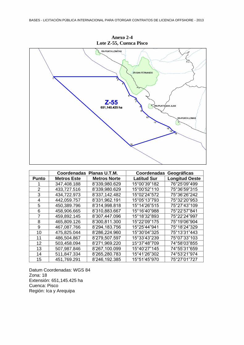
Anexo 2-4
Lote Z-55, Cuenca Pisco
Coordenadas Lote Z-55
Coordenadas Planas U.T.M. Coordenadas Geográficas
Punto Metros Este Metros Norte Latitud Sur Longitud Oeste
1 347,408.188 8’339,980.629 15°00’39”182 76°25’09”499
2 433,727.516 8’339,980.629 15°00’52”110 75°36’59”315
3 434,722.973 8’337,142.482 15°02’24”572 75°36’26”242
4 442,059.757 8’331,962.191 15°05’13”793 75°32’20”953
5 450,389.796 8’314,998.818 15°14’26”515 75°27’43”109
6 458,906.665 8’310,883.667 15°16’40”988 75°22’57”841
7 459,892.145 8’307,447.096 15°18’32”893 75°22’24”997
8 465,809.126 8’300,811.300 15°22’09”175 75°19’06”904
9 467,087.766 8’294,183.756 15°25’44”941 75°18’24”329
10 475,825.044 8’286,224.960 15°30’04”325 75°13’31”443
11 486,504.867 8’279,507.597 15°33’43”239 75°07’33”103
12 503,458.094 8’271,969.220 15°37’48”709 74°58’03”855
13 507,987.846 8’267,100.099 15°40’27”145 74°55’31”659
14 511,847.334 8’265,280.783 15°41’26”302 74°53’21”974
15 451,769.291 8’246,192.385 15°51’45”970 75°27’01”727
Datum Coordenadas: WGS 84 Zona: 18 Extensión: 651,145.425 ha Cuenca: Pisco Región: Ica y Arequipa
BASES - LICITACIÓN PÚBLICA INTERNACIONAL PARA OTORGAR CONTRATOS DE LICENCIA OFFSHORE - 2013
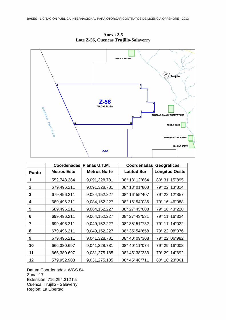
Anexo 2-5
Lote Z-56, Cuencas Trujillo-Salaverry
Coordenadas Lote Z-56
Coordenadas Planas U.T.M. Coordenadas Geográficas
Punto Metros Este Metros Norte Latitud Sur Longitud Oeste
1 552,748.284 9,091,328.781 08° 13' 12"664 80° 31' 15"895
2 679,496.211 9,091,328.781 08° 13' 01"808 79° 22' 13"814
3 679,496.211 9,084,152.227 08° 16' 55"407 79° 22' 12"857
4 689,496.211 9,084,152.227 08° 16' 54"036 79° 16' 46"088
5 689,496.211 9,064,152.227 08° 27' 45"008 79° 16' 43"228
6 699,496.211 9,064,152.227 08° 27' 43"531 79° 11' 16"324
7 699,496.211 9,049,152.227 08° 35' 51"732 79° 11' 14"022
8 679,496.211 9,049,152.227 08° 35' 54"658 79° 22' 08"076
9 679,496.211 9,041,328.781 08° 40' 09"308 79° 22' 06"982
10 666,380.697 9,041,328.781 08° 40' 11"074 79° 29' 16"008
11 666,380.697 9,031,275.185 08° 45' 38"333 79° 29' 14"692
12 579,952.903 9,031,275.185 08° 45' 46"711 80° 16' 23"061
Datum Coordenadas: WGS 84 Zona: 17 Extensión: 716,294.312 ha Cuenca: Trujillo - Salaverry Región: La Libertad
BASES - LICITACIÓN PÚBLICA INTERNACIONAL PARA OTORGAR CONTRATOS DE LICENCIA OFFSHORE - 2013
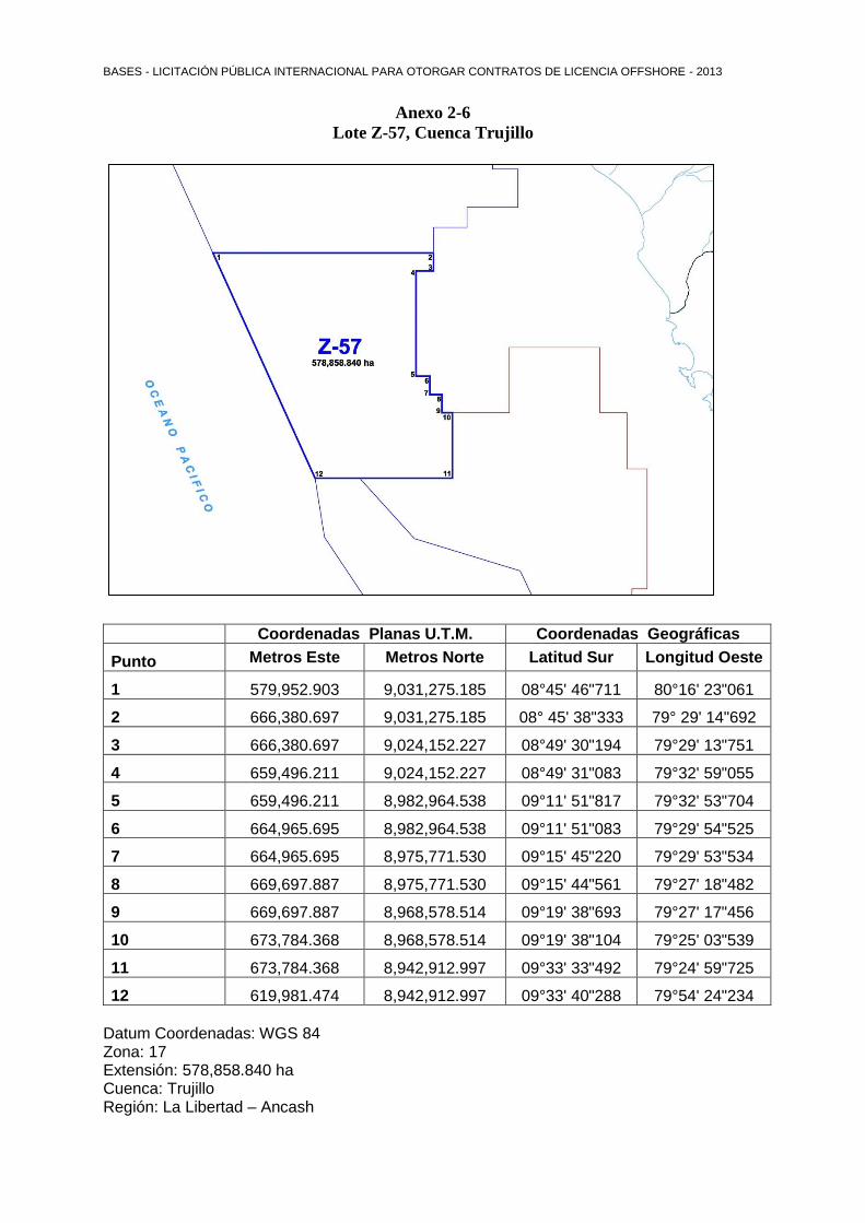
Anexo 2-6
Lote Z-57, Cuenca Trujillo
Coordenadas Lote Z-57
Coordenadas Planas U.T.M. Coordenadas Geográficas
Punto Metros Este Metros Norte Latitud Sur Longitud Oeste
1 579,952.903 9,031,275.185 08°45' 46"711 80°16' 23"061
2 666,380.697 9,031,275.185 08° 45' 38"333 79° 29' 14"692
3 666,380.697 9,024,152.227 08°49' 30"194 79°29' 13"751
4 659,496.211 9,024,152.227 08°49' 31"083 79°32' 59"055
5 659,496.211 8,982,964.538 09°11' 51"817 79°32' 53"704
6 664,965.695 8,982,964.538 09°11' 51"083 79°29' 54"525
7 664,965.695 8,975,771.530 09°15' 45"220 79°29' 53"534
8 669,697.887 8,975,771.530 09°15' 44"561 79°27' 18"482
9 669,697.887 8,968,578.514 09°19' 38"693 79°27' 17"456
10 673,784.368 8,968,578.514 09°19' 38"104 79°25' 03"539
11 673,784.368 8,942,912.997 09°33' 33"492 79°24' 59"725
12 619,981.474 8,942,912.997 09°33' 40"288 79°54' 24"234
Datum Coordenadas: WGS 84 Zona: 17 Extensión: 578,858.840 ha Cuenca: Trujillo Región: La Libertad – Ancash
BASES - LICITACIÓN PÚBLICA INTERNACIONAL PARA OTORGAR CONTRATOS DE LICENCIA OFFSHORE - 2013
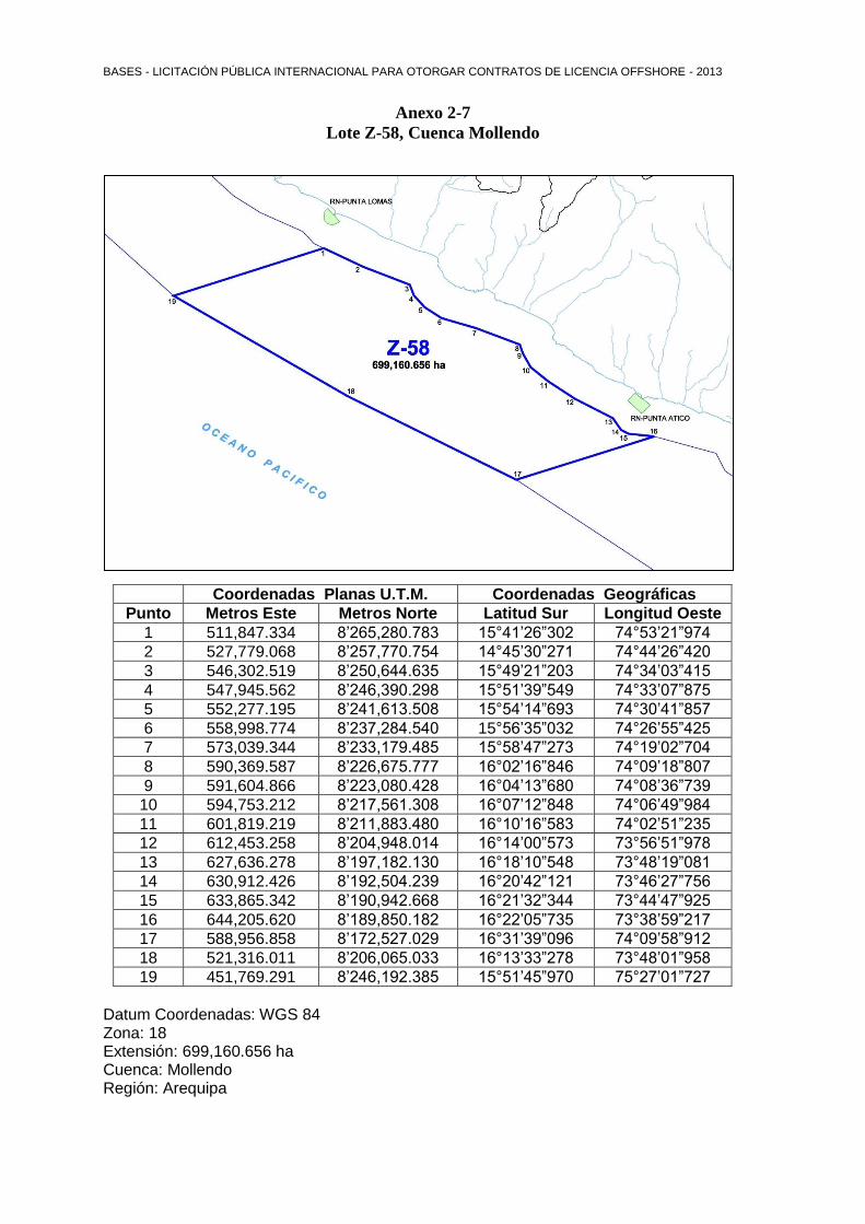
Anexo 2-7
Lote Z-58, Cuenca Mollendo
Coordenadas Lote Z-58
Coordenadas Planas U.T.M. Coordenadas Geográficas
Punto Metros Este Metros Norte Latitud Sur Longitud Oeste
1 511,847.334 8’265,280.783 15°41’26”302 74°53’21”974
2 527,779.068 8’257,770.754 14°45’30”271 74°44’26”420
3 546,302.519 8’250,644.635 15°49’21”203 74°34’03”415
4 547,945.562 8’246,390.298 15°51’39”549 74°33’07”875
5 552,277.195 8’241,613.508 15°54’14”693 74°30’41”857
6 558,998.774 8’237,284.540 15°56’35”032 74°26’55”425
7 573,039.344 8’233,179.485 15°58’47”273 74°19’02”704
8 590,369.587 8’226,675.777 16°02’16”846 74°09’18”807
9 591,604.866 8’223,080.428 16°04’13”680 74°08’36”739
10 594,753.212 8’217,561.308 16°07’12”848 74°06’49”984
11 601,819.219 8’211,883.480 16°10’16”583 74°02’51”235
12 612,453.258 8’204,948.014 16°14’00”573 73°56’51”978
13 627,636.278 8’197,182.130 16°18’10”548 73°48’19”081
14 630,912.426 8’192,504.239 16°20’42”121 73°46’27”756
15 633,865.342 8’190,942.668 16°21’32”344 73°44’47”925
16 644,205.620 8’189,850.182 16°22’05”735 73°38’59”217
17 588,956.858 8’172,527.029 16°31’39”096 74°09’58”912
18 521,316.011 8’206,065.033 16°13’33”278 73°48’01”958
19 451,769.291 8’246,192.385 15°51’45”970 75°27’01”727
Datum Coordenadas: WGS 84 Zona: 18 Extensión: 699,160.656 ha Cuenca: Mollendo Región: Arequipa
BASES - LICITACIÓN PÚBLICA INTERNACIONAL PARA OTORGAR CONTRATOS DE LICENCIA OFFSHORE - 2013
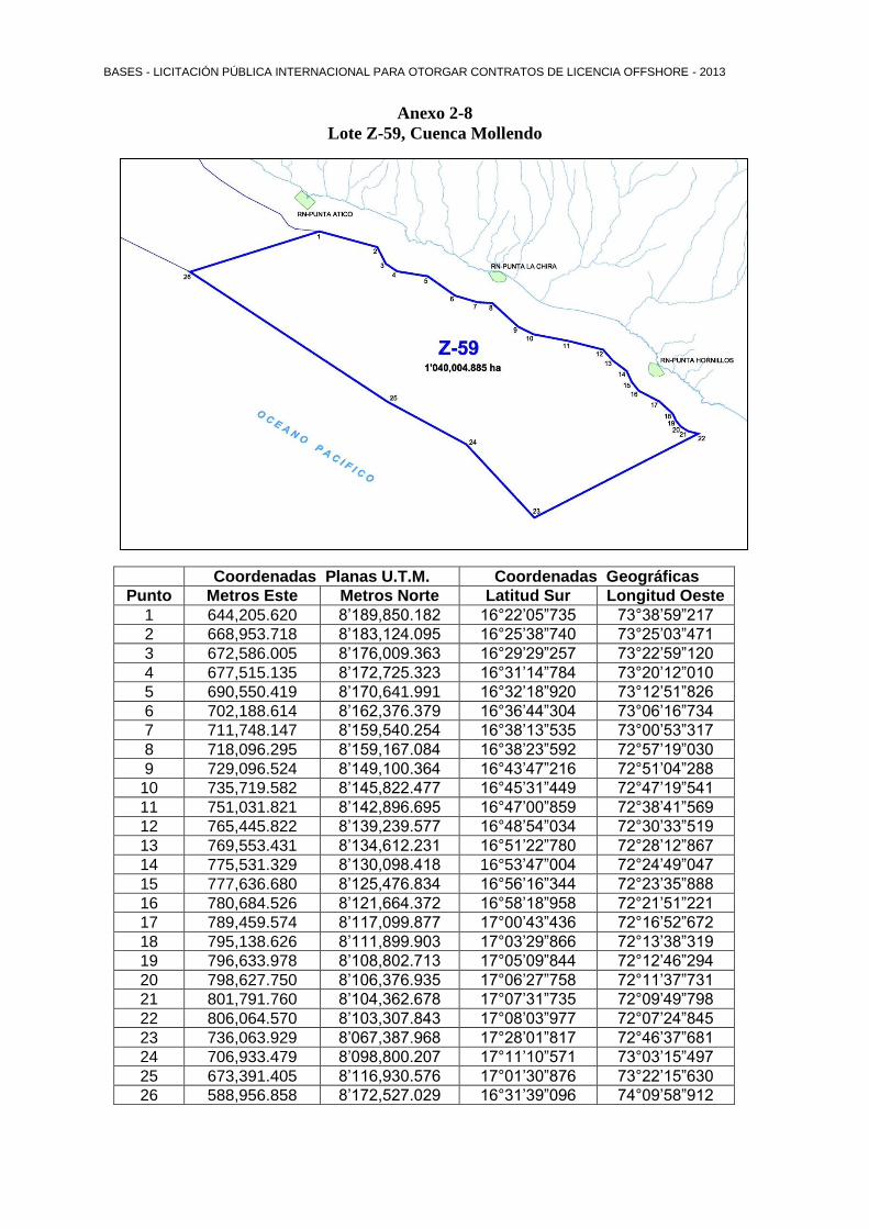
Anexo 2-8
Lote Z-59, Cuenca Mollendo
Coordenadas Lote Z-59
Coordenadas Planas U.T.M. Coordenadas Geográficas
Punto Metros Este Metros Norte Latitud Sur Longitud Oeste
1 644,205.620 8’189,850.182 16°22’05”735 73°38’59”217
2 668,953.718 8’183,124.095 16°25’38”740 73°25’03”471
3 672,586.005 8’176,009.363 16°29’29”257 73°22’59”120
4 677,515.135 8’172,725.323 16°31’14”784 73°20’12”010
5 690,550.419 8’170,641.991 16°32’18”920 73°12’51”826
6 702,188.614 8’162,376.379 16°36’44”304 73°06’16”734
7 711,748.147 8’159,540.254 16°38’13”535 73°00’53”317
8 718,096.295 8’159,167.084 16°38’23”592 72°57’19”030
9 729,096.524 8’149,100.364 16°43’47”216 72°51’04”288
10 735,719.582 8’145,822.477 16°45’31”449 72°47’19”541
11 751,031.821 8’142,896.695 16°47’00”859 72°38’41”569
12 765,445.822 8’139,239.577 16°48’54”034 72°30’33”519
13 769,553.431 8’134,612.231 16°51’22”780 72°28’12”867
14 775,531.329 8’130,098.418 16°53’47”004 72°24’49”047
15 777,636.680 8’125,476.834 16°56’16”344 72°23’35”888
16 780,684.526 8’121,664.372 16°58’18”958 72°21’51”221
17 789,459.574 8’117,099.877 17°00’43”436 72°16’52”672
18 795,138.626 8’111,899.903 17°03’29”866 72°13’38”319
19 796,633.978 8’108,802.713 17°05’09”844 72°12’46”294
20 798,627.750 8’106,376.935 17°06’27”758 72°11’37”731
21 801,791.760 8’104,362.678 17°07’31”735 72°09’49”798
22 806,064.570 8’103,307.843 17°08’03”977 72°07’24”845
23 736,063.929 8’067,387.968 17°28’01”817 72°46’37”681
24 706,933.479 8’098,800.207 17°11’10”571 73°03’15”497
25 673,391.405 8’116,930.576 17°01’30”876 73°22’15”630
26 588,956.858 8’172,527.029 16°31’39”096 74°09’58”912

BASES - LICITACIÓN PÚBLICA INTERNACIONAL PARA OTORGAR CONTRATOS DE LICENCIA OFFSHORE - 2013
Datum Coordenadas: WGS 84 Zona: 18 Extensión: 1’040,004.885 ha Cuenca: Mollendo Región: Arequipa
BASES - LICITACIÓN PÚBLICA INTERNACIONAL PARA OTORGAR CONTRATOS DE LICENCIA OFFSHORE - 2013
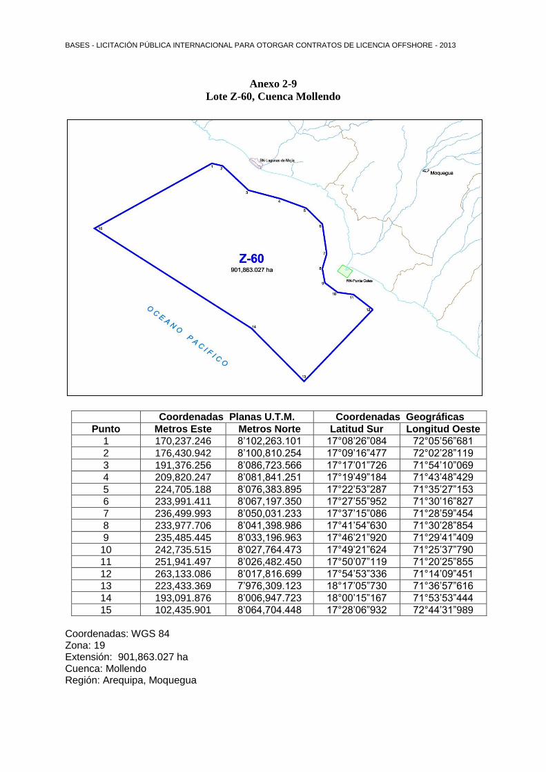
Anexo 2-9
Lote Z-60, Cuenca Mollendo
Coordenadas Planas U.T.M. Coordenadas Geográficas
Punto Metros Este Metros Norte Latitud Sur Longitud Oeste
1 170,237.246 8’102,263.101 17°08’26”084 72°05’56”681
2 176,430.942 8’100,810.254 17°09’16”477 72°02’28”119
3 191,376.256 8’086,723.566 17°17’01”726 71°54’10”069
4 209,820.247 8’081,841.251 17°19’49”184 71°43’48”429
5 224,705.188 8’076,383.895 17°22’53”287 71°35’27”153
6 233,991.411 8’067,197.350 17°27’55”952 71°30’16”827
7 236,499.993 8’050,031.233 17°37’15”086 71°28’59”454
8 233,977.706 8’041,398.986 17°41’54”630 71°30’28”854
9 235,485.445 8’033,196.963 17°46’21”920 71°29’41”409
10 242,735.515 8’027,764.473 17°49’21”624 71°25’37”790
11 251,941.497 8’026,482.450 17°50’07”119 71°20’25”855
12 263,133.086 8’017,816.699 17°54’53”336 71°14’09”451
13 223,433.369 7’976,309.123 18°17’05”730 71°36’57”616
14 193,091.876 8’006,947.723 18°00’15”167 71°53’53”444
15 102,435.901 8’064,704.448 17°28’06”932 72°44’31”989
Coordenadas: WGS 84 Zona: 19 Extensión: 901,863.027 ha
Cuenca: Mollendo Región: Arequipa, Moquegua


![Anexo I: Mapas de Conflicto [PDF 35.25 MB].](https://static.fdocuments.es/doc/165x107/58a2df4e1a28ab8e608bf1dc/anexo-i-mapas-de-conflicto-pdf-3525-mb.jpg)

