Río Mapocho Río Mapocho Todos Los domingos y festivos un viaje ...

Palabras clave: Urbanismo-Chile, historia, desarrollo urbano, políticas públicas, canalización. Key words: Urbanism-Chile, history, urban development, public policies, water distribution.
El Mapocho urbano del s. xix1
Simón Castillo Licenciado en Historia, Pontificia Universidad Católica de Chile
Hay al menos tres formas de estudiar al río Mapocho desde el punto de vista de la historia urbana de la ciudad de Santiago: como relación entre natura-leza y ciudad, como problema ingenieril y arquitectónico y como tema de gestión y desarrollo urbano. Aunque las tres están vinculadas, la primera forma parece ser fundamental, como causa de sucesivas intervenciones. Sin embargo —y aunque parezca contradictorio— aquí se fija la mirada en los dos últimos enfoques: la metodología será comprender las relaciones entre naturaleza y sociedad urbana como horizonte proyectual y disciplina-rio, donde intervienen elementos de la urbanística moderna y del control social ligados a procesos de modernización. Como problema de la sociedad urbana, tanto lo técnico como la gestión son considerados como dos esferas culturales que abordan las intervenciones urbanísticas desde los discursos del poder, comprendiendo sus nexos con las representaciones de ciudad. Para estos efectos se ha estudiado el río Mapocho de fines del s. xix. Durante ese período se produjo la canalización del río en su tramo urbano —entre las calles Pío ix y Manuel Rodríguez— incluyendo la destrucción del puente de Cal y Canto, así como la construcción de edificios, puentes y parques públicos. Simultáneamente se produjo el fin de una larga faja de basurales y la erradicación de miles de habitantes desde sus riberas céntricas hacia otros sectores. Este proceso de modernización modificó drásticamente la imagen de ciudad, así como la conectividad entre el casco histórico —al sur del río— y el área de La Chimba —al norte de él—. Por ello, se pretende esta-blecer algunas relaciones entre operaciones de infraestructura y cuestiones político-sociales, considerando al río Mapocho como un artefacto urbano —materia convertida en problema cultural— que desencadenó diferentes representaciones de ciudad, al igual que la aparición de nuevos actores en el espacio público. el urbanismo como problema político-cultural / En 1996, el arquitecto Mario Pérez de Arce Lavín —prolífico estudioso del río Mapocho— señaló que “es incom-prensible que las municipalidades ribereñas, sobre todo en el sector oriente, no hayan tomado posesión de la franja pública a lo largo del cauce, ni la hayan definido cla-ramente, permitiendo que se generen conflictos de dominio al aumentar el valor de los terrenos vecinos” (Pérez de Arce, 1996). Se requeriría abordar, además del problema urbano-territorial, las relaciones entre lo público y lo privado y el gobierno de la ciudad. Se debe recordar que desde 1850 hubo novedosas formas de entender Santiago, basadas tanto en cambios internos como en las transferencias urba-nísticas (Hardoy, 1988) entre Europa, Estados Unidos y Latinoamérica. La migración campo-ciudad impactó tanto en su extensión y fisonomía como en las relaciones y prácticas sociales que en ella se produjeron. Desde la elite, Benjamín Vicuña Mackenna (intendente en el período 1872-74) fue el arti-culador y condensador de las interpretaciones sobre las nuevas realidades urbanas: sabida es su drástica separación entre la ciudad propia y la ciudad bárbara, materializada a través de un camino de cintura. También la inaugu-ración de obras públicas monumentales, como la transformación del pedre-goso cerro Santa Lucía en espacio público. El dominio de la naturaleza representado en la transformación del Santa
46 Lecturas Readings72
History is one of the factors that form a city. With respect to the relationship between Santiago and the Mapocho River throughout the 19th century, this fact becomes crucial. The relationships between the northern and southern riversides and the city, and between the junctions and the east-west river beds, bring the social, political, and urban problems to light.
La historia es uno de los factores que da forma a la ciudad. En la relación entre Santiago y el río Mapocho, a través del s. xix, este soporte se vuelve crucial; las relaciones entre sus riberas norte y sur con la ciudad, sus cruces y su cauce oriente-poniente dan cuenta de problemáticas sociales, políticas y urbanísticas.
19th Century Urban Mapocho1
Simón Castillo Licensed in History, Pontificia Universidad Católica de Chile
There are at least three ways to study the Mapocho river from the per-spective of Santiago’s urban history: as a relationship between nature and city, as an engineering and architectural problem, and as a man-agement and urban development matter. Even though the three are related, the first appears to be fundamental, as the cause of successive interventions. Regardless, even if it seems contradictory, we will take a look at the last two forms. The methodology will be to understand the relationships between nature and urban society, as a design and disci-plinary platform, where elements of modern urbanism and the social control tied to processes of modernization intervene. As a problem of urban society, the technical as well as the managerial are considered as two cultural spheres that approach urban interventions from the dis-course of groups of power, including its nexus with the representations of the city. The study of the 19th century Mapocho River has been proposed to approach these phenomena. During this time, the river was canalized in its urban stretch, between streets such as Pío ix and Manuel Rodríguez; also the Cal y Canto Bridge was destroyed, and buildings, bridges, and public parks were constructed. At the same time the elimination of a long belt of waste piles, and the eradication of thousands of inhabitants from the river’s centric bank to other sectors, took place. This modern-ization process drastically modified the image of the city, as well as the connection between the historic core —to the south of the river— and La Chimba area, to the north of it. Because of this, we intend to estab-lish relationships between operations of infrastructure and socio-polit-ical matters, treating the Mapocho River like an urban artifact (matter turned into cultural problem), which unfolded different representations of the city, as well as the appearance of new actors in the public space. political urbanism - cultural urbanism / In 1996, the architect Mario Pérez de Arce Lavín, a prolific scholar of the Mapocho, indicated that “it is incomprehensible that the riverside municipalities, especially in the eastern sector, haven’t taken possession of the public fringe along the riverbed, nor have they clearly defined it, allowing the creation of conflicts of dominion as the value of neighboring lands increase”. Besides the urban territorial problem, rela-tionships between the public, the private, and the government of the city should be discussed. It should be noted that since 1850, novel ways of viewing Santiago emerged, based on internal changes as much as on urban transferences (Hardoy, 1988) between Europe, the United States, and Latin America. The migration from country to city made an impact, as much as in its extent and physiognomy, as in the social relations and practices that it created. Within the elite, Intendant Benjamín Vicuña Mackenna (1872-74) was the articulator and condenser of interpretations regarding new urban realities. He is well known for his drastic separation between proper city and barbaric city, materialized through the camino de cintura2, as well as for the inauguration of public monumental works, such as the transformation of rocky Santa Lucía hill into public space.

72Lecturas Readings 47
1 Artículo derivado de la tesis doctoral del autor, Facultad de Arquitectura, Diseño y Estudios Urbanos, Pontificia Universidad Católica de Chile. El autor agradece especialmente a su profesor guía Francisco Liernur.
2 Name of a road that surrounded the consolidated areas of Santiago during the second half of 19th century (Editor’s note).
Lucía tuvo su correlato hídrico: el interés por canalizar el Mapocho. Desde la Colonia el río había tenido una importancia simbólica y material gracias a los tajamares y al majestuoso puente de Cal y Canto. Pero su ancho y pedregoso cauce era un límite que había dividido la ciudad, inundándola constante-mente con sus desbordes y provocando enormes daños humanos y materiales. Aunque en verano las riberas estaban comunicadas, entre abril y octubre toda el área norte no estaba integrada a los flujos y a la trama urbana. Debido a su inestabilidad, el cauce tuvo uno de los precios de suelo más baratos de Santiago; en él se establecieron grupos marginales para construir sus viviendas y trabajar en la extracción de ripio y arena. Lentamente, esos habitantes aumentaron y comenzaron a molestar al patriciado urbano: eran residentes indeseables, tanto porque su trabajo desestabilizaba el cauce, como por su estética que irrumpía en la misma cara de la ciudad propia. En otras palabras: tanto el torrente del río como aquellos pobladores ribereños se percibieron como obstáculos para lo que era considerado como imagen de ciudad moderna. En 1873; el intendente y una comisión auspiciada por el empresario minero Luis Cousiño elaboraron el primer plan de canalización del torrente, dirigi-dos por el ingeniero Ernesto Ansart. Asumiendo la diferencia radical entre la cuadrícula del casco histórico y los irregulares caminos semirrurales de La Chimba, esta fue la primera herramienta planimétrica en establecer un área de canalización —entre calles Manuel Rodríguez y la actual Condell— y los terrenos que se ganarían al Mapocho. Pero sólo gracias al dinero del salitre, en la década de 1880, aquel límite fue intervenido por las autoridades del diseño y gobierno urbano. Destacó en ello el presidente José Manuel Balmaceda, creador del Ministerio de Industria y Obras Públicas (1887). Paralelamente, se verificó el auge del higienismo, que veía a los pobres de la ciudad como los prin-cipales transmisores de epidemias, mediante los miasmas. Emergieron así los médicos como nuevos actores políticos, con un discurso urbano-preventivo que calzó con las propuestas reformistas para Santiago.
01 Río Mapocho, altura puente de palo frente a calle San Antonio, c. 1870. Fuente: Colección Museo Histórico Nacional 01 Mapocho River, at wood bridge in front of San Antonio Street, c. 1870. Source: Museo Histórico Nacional Collection
Control of nature represented in the transformation of Santa Lucía, had its hydric correlation: the interest in canalizing the Mapocho. Since colo-nial times the river had had symbolic and material importance, thanks to the cutwaters and the majestic Cal y Canto Bridge. But its wide and rocky riverbed was a limit that divided the city, constantly drowning it with its flooding and provoking great human and material damage. Even though in the summer the riverbanks were connected, between April and October the entire north area wasn’t integrated with urban flow and life. Due to its instability, the riverbed had one of the cheapest land values in Santiago, attracting plebeian groups to build their homes and work in extraction of gravel and sand. Slowly these inhabitants increased in num-bers and began to disturb the urban patrician class: they were undesirable residents, because their work destabilized the riverbed, and because of their esthetic of marginality, in the very face of the proper city. In other words the river current, as well as the riverside dwellers, was perceived as an obstacle for what was considered to be the image of a modern city. In 1873 the Intendant and a committee sponsored by Luis Cousiño, a mining businessman, crafted the first plan to canalize the current, directed by the engineer Ernesto Ansart. Assuming the radical difference between down-town’s grid and the irregular semi-rural paths of La Chimba, the plan was the first planimetric tool in establishing an area of canalization, between Manuel Rodríguez and present Condell streets, and the lands that would be gained from the Mapocho. But only during the decade of 1880, thanks to nitrate money, authorities of urban design and government could inter-vene the riverbanks. Standing out in this matter was President José Manuel Balmaceda, creator of the Ministry of Industry and Public Works (1887). At the same time, the rise of hygienism took place, which viewed the city’s poor as the main transmitters of epidemics through miasmas. This is how doc-tors emerged as new political actors, with urban-preventive discourse that complemented the reformist proposals for Santiago.
1 Article derived from the Doctoral Thesis of the author, Facultad de Arquitectura, Diseño y Estudios Urbanos, Pontificia Universidad Católica de Chile. The author espe-cially thanks his advisor Professor Francisco Liernur.
2 Name of a road that surrounded the consolidated areas of Santiago during the second half of 19th century (Editor’s note).

En ese contexto comenzó la transformación de río a canal en su área urbana, propiciando el derrumbe del puente de Cal y Canto. En estas obras destacó Valentín Martínez, ingeniero de la Universidad de Chile y jefe ministerial de la sección de puentes, caminos y obras hidráulicas. La caída del puente colonial marcó un quiebre en la manera de entender la ciudad, en la repre-sentación de qué era la modernidad y cómo se materializaba en lo urbano. Y es que las figuraciones de Martínez respecto al torrente eran lapidarias: una “zona pestilente y sucia”, sólo subsanable imitando a Europa, quedando el barrio Mapocho “a la altura de los mejores barrios de París y Londres”. Martínez presentó dos proyectos (1885 y 1888), aprobándose el segundo con una ley que señaló que el Poder Ejecutivo realizaría la transformación a “cien metros a uno y otro lado del canal en toda su extensión” para, al finalizarla, ceder dichos terrenos al municipio de Santiago. Entraron en juego entonces nuevos acto-res —ingenieros y arquitectos—, también nuevos soportes —materiales como el acero de los puentes, la maquinaria pesada de removimiento de tierras— y especialmente nuevas técnicas, como el desarrollo de un proyecto políti-camente transversal, asociado a la idea de expansión urbana, continuado incluso durante los ocho meses de la guerra civil de 1891. Las intervenciones también disciplinaron lentamente las bases materiales y culturales de los sectores populares del lugar. Aunque desde la época de la Colonia hubo erradicaciones de población, hacia 1890 la molestia de las autoridades era evidente. Probablemente, ese desagrado se extendía a coci-nerías y otros establecimientos efímeros de las orillas. En ese diagnóstico coincidieron todos los poderes estatales: si para Martínez era “zona pestilente y sucia”, para el congresista Paulino Alfonso era un “barbecho colosal de gérme-nes malsanos”, un “dilatado cáncer asqueroso” y la “vergüenza de nuestro país”. En 1898, algunos concejales municipales fueron más directos, eran “gentes que avergüenzan con su vida y oficio la cultura de la ciudad”. Esta suerte de cáncer por extirpar incluyó a las viejas casas coloniales de adobe y teja (calles Mapocho, Esmeralda, Dávila) donde vivía un gran número de gente. Muchas albergaban espacios de sociabilidad popular, como bares y prostíbulos. Comenzó a incubarse así una representación de aquellas edi-ficaciones como un artefacto urbano detestable: un anti-monumento. Paulati-namente, la degeneración material se convirtió en sinónimo de anti-higiene moral, culminando en una intervención urbanística como rectificación sociocultural. El método a seguir fue la intromisión en el espacio público, pero también en el privado; con preferencia en calles, plazas y fachadas de viviendas, pero también en la intimidad de los sectores más modestos. Entre 1887 y 1900 se verificó una batería de propuestas y construcciones que modificaron las riberas urbanas, mayoritariamente cristalizadas por el Minis-terio de Industria y Obras Públicas: la Cárcel Pública (1887), canalización, puen-tes metálicos y obeliscos conmemorativos (1888-1892), la pequeña estación del Mercado (1888), edificios de higiene y caridad (Desinfectorio Público e Instituto de Higiene, 1896-1900; Patronato Nacional de la Infancia, c.1905) y edificios de comercio, como la Vega Central y los Galpones de Zapateros (1890-1900). Simul-táneamente y gracias a los terrenos subidos de nivel por la canalización, desde 1895 comenzaron las plantaciones que originarían el Parque Forestal, que erró-neamente se data como obra del centenario de la independencia.
Modificar el río fue entonces un ambicioso afán de creación de un paisaje urbano, es decir, una relación entre naturaleza, sociedad y ciudad desde la cristalización de ideas urbanísticas modernas en el espacio público. Hipoté-ticamente, podría plantearse que la transformación de los bordes del río fue inédita, por ser una modernización con nuevas dimensiones. El principal argumento es que ocupó una escala mayor a anteriores operaciones públi-cas urbanas —generalmente obras puntuales insertas en un contexto físico barrial— implementándose quizás por primera vez a un rango de ciudad o de lo que podríamos llamar ciudad moderna. Pero estas operaciones de infraestructura no siguieron un conducto mecá-nico, sino que fueron resultado de disputas entre los poderes estatales. He aquí una respuesta tentativa a la pregunta de Pérez de Arce: en la transfor-mación del Mapocho de finales del s. xix —y probablemente en las ocurridas durante el xx— no hubo un plan maestro, sistemático y coordinado por parte del Estado. Más bien voluntades políticas, culturales y estéticas coincidentes en una intervención urbanística que, junto con producir ganancias econó-micas e higiénicas, propiciara también un disciplinamiento social. Sin embargo esa gestión pública se restringió al tramo central, precisa-mente cuando la expansión urbana comenzaba a colonizar el norponiente (Quinta Normal). Y si bien, después de muchas batallas legales con los privados, el Estado construiría parques de borde-río hacia el poniente y el oriente de la primera canalización (el pequeño Parque Centenario y los de la comuna de Providencia, respectivamente) prevalecería durante décadas lo que Pérez de Arce llamó “conflictos de dominio” sin una posesión efectiva de aquella franjas públicas. Es indiscutible el reciente aporte del Parque Bicentenario en Vitacura, como es de esperar lo sea el parque inundable La Hondonada, que buscará mejorar el aire de Cerro Navia y Pudahuel. La tarea parece especialmente difícil en esta última comuna: con los mayores índices de contaminación del área metropolitana debido al amoníaco emanado por el río, sus extensos asentamientos precarios ribereños son la forma contem-poránea de la decimonónica ciudad bárbara que se niega a morir.
BibliografíaAlfonso, Paulino. Lo que debe hacerse con los terrenos del Mapocho. Imprenta Cer-vantes, Santiago, 1892. / Ansart, Ernesto. “La canalización del Mapocho”. Ori-ginal de 1873. Revista de la Sociedad Chilena de Ingeniería Hidráulica Nº 1, vol. 4. Sociedad Chilena de Ingeniería Hidráulica, Santiago, 1989. / Bórquez, Óscar. Historia del río Mapocho y sus puentes. Seminario de Historia de Arquitectura, Escuela de Arquitectura de la Universidad de Chile, Santiago, 1959. / Hardoy, Jorge. “Teorías y prácticas urbanísticas en Europa entre 1850 y 1930. Su tras-lado a América Latina”. Hardoy, Jorge y Richard Morse (compiladores). Repen-sando la ciudad de América Latina. Grupo Editor Latinoamericano, Buenos Aires, 1988. / Martínez, Valentín. Proyecto para la canalización del río Mapocho. Imprenta Cervantes, Santiago, 1888. / Pérez de Arce, Mario. “La ciudad y el río”. ARQ Nº 34. Ediciones ARQ, Santiago, noviembre de 1996. / Vicuña Mac-kenna, Benjamín. La transformación de Santiago. Notas e indicaciones a la Ilustre Municipalidad, al Supremo Gobierno y al Congreso Nacional. Imprenta Librería del Mercurio, Santiago, 1872.
48 Lecturas Readings72
02 Ernesto Ansart. Plano del río Mapocho con indicación del canal y las manzanas conquistadas, 1873. Fuente: Ansart, 187302 Ernesto Ansart. Plan of the Mapocho River with indication of the canal and the seized blocks, 1873. Source: Ansart, 1873
72Lecturas Readings 49
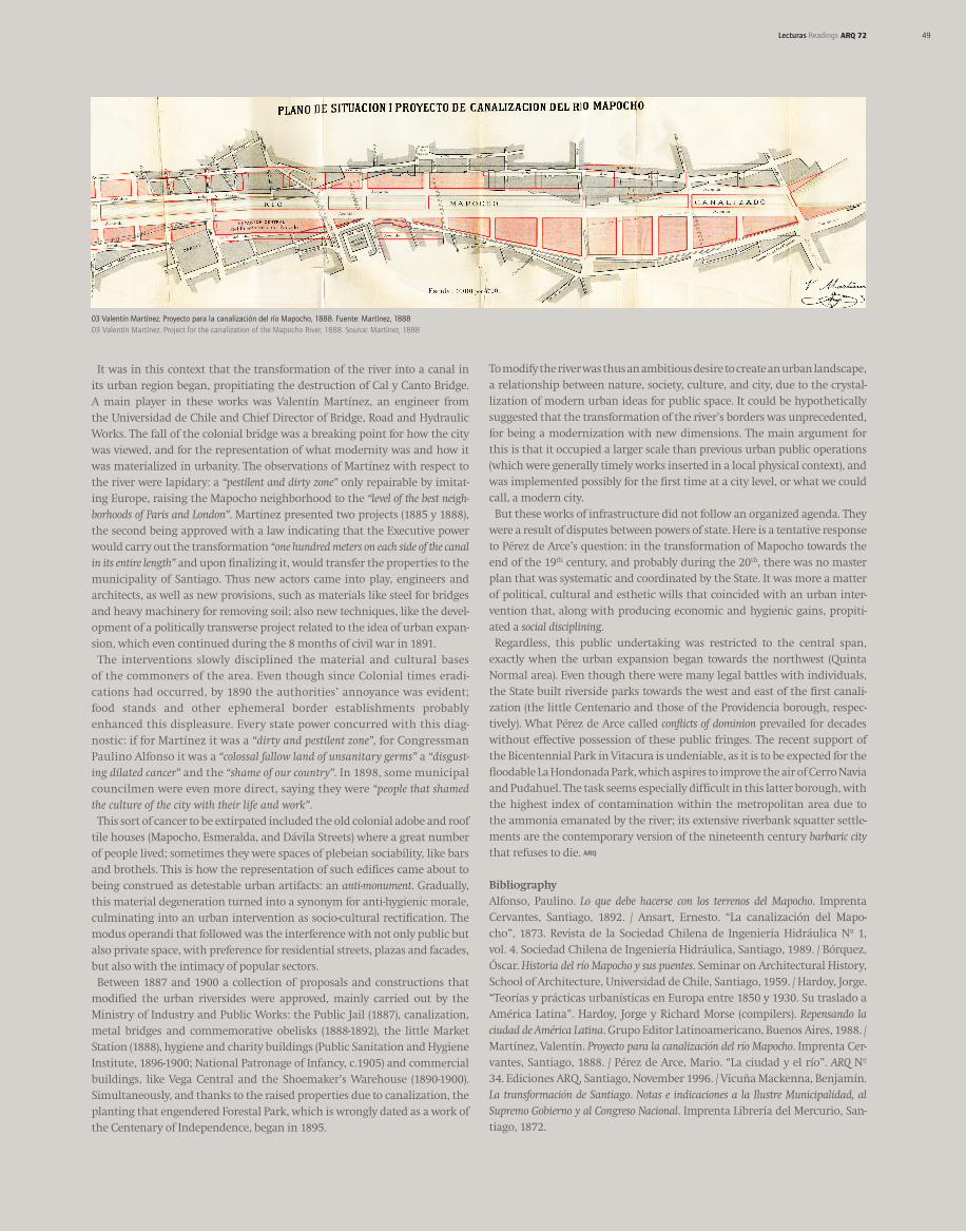
It was in this context that the transformation of the river into a canal in its urban region began, propitiating the destruction of Cal y Canto Bridge. A main player in these works was Valentín Martínez, an engineer from the Universidad de Chile and Chief Director of Bridge, Road and Hydraulic Works. The fall of the colonial bridge was a breaking point for how the city was viewed, and for the representation of what modernity was and how it was materialized in urbanity. The observations of Martínez with respect to the river were lapidary: a “pestilent and dirty zone” only repairable by imitat-ing Europe, raising the Mapocho neighborhood to the “level of the best neigh-borhoods of Paris and London”. Martínez presented two projects (1885 y 1888), the second being approved with a law indicating that the Executive power would carry out the transformation “one hundred meters on each side of the canal in its entire length” and upon finalizing it, would transfer the properties to the municipality of Santiago. Thus new actors came into play, engineers and architects, as well as new provisions, such as materials like steel for bridges and heavy machinery for removing soil; also new techniques, like the devel-opment of a politically transverse project related to the idea of urban expan-sion, which even continued during the 8 months of civil war in 1891. The interventions slowly disciplined the material and cultural bases of the commoners of the area. Even though since Colonial times eradi-cations had occurred, by 1890 the authorities’ annoyance was evident; food stands and other ephemeral border establishments probably enhanced this displeasure. Every state power concurred with this diag-nostic: if for Martínez it was a “dirty and pestilent zone”, for Congressman Paulino Alfonso it was a “colossal fallow land of unsanitary germs” a “disgust-ing dilated cancer” and the “shame of our country”. In 1898, some municipal councilmen were even more direct, saying they were “people that shamed the culture of the city with their life and work”. This sort of cancer to be extirpated included the old colonial adobe and roof tile houses (Mapocho, Esmeralda, and Dávila Streets) where a great number of people lived; sometimes they were spaces of plebeian sociability, like bars and brothels. This is how the representation of such edifices came about to being construed as detestable urban artifacts: an anti-monument. Gradually, this material degeneration turned into a synonym for anti-hygienic morale, culminating into an urban intervention as socio-cultural rectification. The modus operandi that followed was the interference with not only public but also private space, with preference for residential streets, plazas and facades, but also with the intimacy of popular sectors. Between 1887 and 1900 a collection of proposals and constructions that modified the urban riversides were approved, mainly carried out by the Ministry of Industry and Public Works: the Public Jail (1887), canalization, metal bridges and commemorative obelisks (1888-1892), the little Market Station (1888), hygiene and charity buildings (Public Sanitation and Hygiene Institute, 1896-1900; National Patronage of Infancy, c.1905) and commercial buildings, like Vega Central and the Shoemaker’s Warehouse (1890-1900). Simultaneously, and thanks to the raised properties due to canalization, the planting that engendered Forestal Park, which is wrongly dated as a work of the Centenary of Independence, began in 1895.
03 Valentín Martínez. Proyecto para la canalización del río Mapocho, 1888. Fuente: Martínez, 1888 03 Valentín Martínez. Project for the canalization of the Mapocho River, 1888. Source: Martínez, 1888
To modify the river was thus an ambitious desire to create an urban landscape, a relationship between nature, society, culture, and city, due to the crystal-lization of modern urban ideas for public space. It could be hypothetically suggested that the transformation of the river’s borders was unprecedented, for being a modernization with new dimensions. The main argument for this is that it occupied a larger scale than previous urban public operations (which were generally timely works inserted in a local physical context), and was implemented possibly for the first time at a city level, or what we could call, a modern city. But these works of infrastructure did not follow an organized agenda. They were a result of disputes between powers of state. Here is a tentative response to Pérez de Arce’s question: in the transformation of Mapocho towards the end of the 19th century, and probably during the 20th, there was no master plan that was systematic and coordinated by the State. It was more a matter of political, cultural and esthetic wills that coincided with an urban inter-vention that, along with producing economic and hygienic gains, propiti-ated a social disciplining. Regardless, this public undertaking was restricted to the central span, exactly when the urban expansion began towards the northwest (Quinta Normal area). Even though there were many legal battles with individuals, the State built riverside parks towards the west and east of the first canali-zation (the little Centenario and those of the Providencia borough, respec-tively). What Pérez de Arce called conflicts of dominion prevailed for decades without effective possession of these public fringes. The recent support of the Bicentennial Park in Vitacura is undeniable, as it is to be expected for the floodable La Hondonada Park, which aspires to improve the air of Cerro Navia and Pudahuel. The task seems especially difficult in this latter borough, with the highest index of contamination within the metropolitan area due to the ammonia emanated by the river; its extensive riverbank squatter settle-ments are the contemporary version of the nineteenth century barbaric city that refuses to die.
BibliographyAlfonso, Paulino. Lo que debe hacerse con los terrenos del Mapocho. Imprenta Cervantes, Santiago, 1892. / Ansart, Ernesto. “La canalización del Mapo-cho”, 1873. Revista de la Sociedad Chilena de Ingeniería Hidráulica Nº 1, vol. 4. Sociedad Chilena de Ingeniería Hidráulica, Santiago, 1989. / Bórquez, Óscar. Historia del río Mapocho y sus puentes. Seminar on Architectural History, School of Architecture, Universidad de Chile, Santiago, 1959. / Hardoy, Jorge. “Teorías y prácticas urbanísticas en Europa entre 1850 y 1930. Su traslado a América Latina”. Hardoy, Jorge y Richard Morse (compilers). Repensando la ciudad de América Latina. Grupo Editor Latinoamericano, Buenos Aires, 1988. / Martínez, Valentín. Proyecto para la canalización del río Mapocho. Imprenta Cer-vantes, Santiago, 1888. / Pérez de Arce, Mario. “La ciudad y el río”. ARQ Nº 34. Ediciones ARQ, Santiago, November 1996. / Vicuña Mackenna, Benjamín. La transformación de Santiago. Notas e indicaciones a la Ilustre Municipalidad, al Supremo Gobierno y al Congreso Nacional. Imprenta Librería del Mercurio, San-tiago, 1872.