Environmental history of southern Patagonia unravelled by ... · Environmental history of southern...
20
Environmental history of southern Patagonia unravelled by the seismic stratigraphy of Laguna Potrok Aike FLAVIO S. ANSELMETTI*, DANIEL ARIZTEGUI , MARC DE BATIST à , A. CATALINA GEBHARDT§, TORSTEN HABERZETTL – , FRANK NIESSEN§, CHRISTIAN OHLENDORF** and BERND ZOLITSCHKA** *Eawag, Swiss Federal Institute of Aquatic Science and Technology, Department of Surface Waters, U ¨ berlandstrasse 133, CH-8600 Du ¨ bendorf, Switzerland (E-mail: fl[email protected]) Section of Earth Sciences, University of Geneva, CH-1205 Geneva, Switzerland àRenard Centre of Marine Geology, Universiteit Gent, B-9000 Gent, Belgium §Alfred-Wegener-Institut fu ¨ r Polar- und Meeresforschung (AWI), D-27570 Bremerhaven, Germany –ISMER, University of Que ´bec, Rimouski, Que ´bec, G5L 3A1, Canada **Institute of Geography, University of Bremen, D-28359 Bremen, Germany Associate Editor: Nick Eyles ABSTRACT Laguna Potrok Aike, located in southernmost Patagonia (Argentina, 52°S) is a 100 m deep hydrologically closed lake that probably provides the only continental southern Patagonian archive covering a long and continuous interval of several glacial to interglacial cycles. In the context of the planned ‘International Continental Scientific Drilling Program’ initiative ‘Potrok Aike Maar Lake Sediment Archive Drilling Project’, several seismic site surveys that characterize in detail the sedimentary subsurface of the lake have been undertaken. Long sediment cores recovered the material to date and calibrate these seismic data. Laguna Potrok Aike is rimmed steeply, circular in shape with a diameter of 3Æ5 km and is surrounded by a series of subaerial palaeoshorelines, reflecting varying lake-level highstands and lowstands. Seismic data indicate a basinwide erosional unconformity that occurs consistently on the shoulder of the lake down to a depth of )33 m (below 2003 ad lake level), marking the lowest lake level during Late Glacial to Holocene times. Cores that penetrate this unconformity comprise Marine Isotope Stage 3-dated sediments (45 kyr bp) 3Æ5m below, and post-6800 cal yr bp transgressional sediments above the unconformity. This Middle Holocene transgression following an unprecedented lake-level lowstand marks the onset of a stepwise change in moisture, as shown by a series of up to 11 buried palaeoshorelines that were formed during lake-level stillstands at depths between )30 and )12 m. Two series of regressive shorelines between 5800 to 5400 and 4700 to 4000 cal yr bp interrupt the overall transgressional trend. In the basin, mound-like drift sediments occur after 6000 cal yr bp, documenting the onset of lake currents triggered by a latitudinal shift or an increase in wind intensity of the Southern Hemispheric Westerlies over Laguna Potrok Aike at that time. Furthermore, several well-defined lateral slides can be recognized. The majority of these slides occurred during the mid-Holocene lake-level lowering when the slopes became rapidly sediment-charged because of erosion from the exposed shoulder sediments. Around 7800 and 4900 cal yr bp, several slides went down simultaneously, probably triggered by seismic shaking. Keywords Lake-level changes, lake sediments, maar lake, palaeoclimate, Patagonia, seismic stratigraphy, Westerlies. Sedimentology (2009) 56, 873–892 doi: 10.1111/j.1365-3091.2008.01002.x Ó 2008 The Authors. Journal compilation Ó 2008 International Association of Sedimentologists 873
Transcript of Environmental history of southern Patagonia unravelled by ... · Environmental history of southern...
Environmental history of southern Patagonia unravelledby the seismic stratigraphy of Laguna Potrok Aike
FLAVIO S. ANSELMETTI*, DANIEL ARIZTEGUI� , MARC DE BATIST� , A. CATALINAGEBHARDT§, TORSTEN HABERZETTL– , FRANK NIESSEN§, CHRISTIAN OHLENDORF**and BERND ZOLITSCHKA***Eawag, Swiss Federal Institute of Aquatic Science and Technology, Department of Surface Waters,Uberlandstrasse 133, CH-8600 Dubendorf, Switzerland (E-mail: [email protected])�Section of Earth Sciences, University of Geneva, CH-1205 Geneva, Switzerland�Renard Centre of Marine Geology, Universiteit Gent, B-9000 Gent, Belgium§Alfred-Wegener-Institut fur Polar- und Meeresforschung (AWI), D-27570 Bremerhaven, Germany–ISMER, University of Quebec, Rimouski, Quebec, G5L 3A1, Canada**Institute of Geography, University of Bremen, D-28359 Bremen, Germany
Associate Editor: Nick Eyles
ABSTRACT
Laguna Potrok Aike, located in southernmost Patagonia (Argentina, 52�S) is a
100 m deep hydrologically closed lake that probably provides the only
continental southern Patagonian archive covering a long and continuous
interval of several glacial to interglacial cycles. In the context of the planned
‘International Continental Scientific Drilling Program’ initiative ‘Potrok Aike
Maar Lake Sediment Archive Drilling Project’, several seismic site surveys that
characterize in detail the sedimentary subsurface of the lake have been
undertaken. Long sediment cores recovered the material to date and calibrate
these seismic data. Laguna Potrok Aike is rimmed steeply, circular in shape with
a diameter of �3Æ5 km and is surrounded by a series of subaerial
palaeoshorelines, reflecting varying lake-level highstands and lowstands.
Seismic data indicate a basinwide erosional unconformity that occurs
consistently on the shoulder of the lake down to a depth of )33 m (below 2003
ad lake level), marking the lowest lake level during Late Glacial to Holocene
times. Cores that penetrate this unconformity comprise Marine Isotope Stage
3-dated sediments (45 kyr bp) �3Æ5 m below, and post-6800 cal yr bp
transgressional sediments above the unconformity. This Middle Holocene
transgression following an unprecedented lake-level lowstand marks the onset
of a stepwise change in moisture, as shown by a series of up to 11 buried
palaeoshorelines that were formed during lake-level stillstands at depths
between )30 and )12 m. Two series of regressive shorelines between �5800 to
5400 and �4700 to 4000 cal yr bp interrupt the overall transgressional trend. In
the basin, mound-like drift sediments occur after �6000 cal yr bp, documenting
the onset of lake currents triggered by a latitudinal shift or an increase in wind
intensity of the Southern Hemispheric Westerlies over Laguna Potrok Aike at
that time. Furthermore, several well-defined lateral slides can be recognized.
The majority of these slides occurred during the mid-Holocene lake-level
lowering when the slopes became rapidly sediment-charged because of erosion
from the exposed shoulder sediments. Around 7800 and 4900 cal yr bp, several
slides went down simultaneously, probably triggered by seismic shaking.
Keywords Lake-level changes, lake sediments, maar lake, palaeoclimate,Patagonia, seismic stratigraphy, Westerlies.
Sedimentology (2009) 56, 873–892 doi: 10.1111/j.1365-3091.2008.01002.x
� 2008 The Authors. Journal compilation � 2008 International Association of Sedimentologists 873
INTRODUCTION
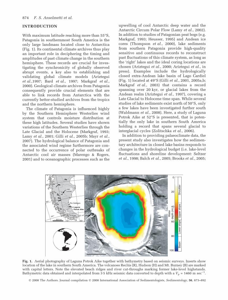
With maximum latitude reaching more than 55�S,Patagonia in southernmost South America is theonly large landmass located close to Antarctica(Fig. 1). Its continental climate archives thus playan important role in deciphering the timing andamplitudes of past climate change in the southernhemisphere. These records are crucial for inves-tigating the synchronicity of globally observedabrupt events, a key also to establishing andvalidating global climate models (Arizteguiet al.,1997; Bard et al., 1997; Markgraf et al.,2000). Geological climate archives from Patagoniaconsequently provide crucial elements that areable to link records from Antarctica with thecurrently better-studied archives from the tropicsand the northern hemisphere.
The climate of Patagonia is influenced highlyby the Southern Hemisphere Westerlies windsystem that controls moisture distribution atthese high latitudes. Several studies have shownvariations of the Southern Westerlies through theLate Glacial and the Holocene (Markgraf, 1993;Lamy et al., 2001; Gilli et al., 2005b; Mayr et al.,2007). The hydrological balance of Patagonia andthe associated wind regime furthermore are con-nected to the occurrence of polar outbreaks ofAntarctic cool air masses (Marengo & Rogers,2001) and to oceanographic processes such as the
upwelling of cool Antarctic deep water and theAntarctic Circum Polar Flow (Lamy et al., 2002).In addition to studies of Patagonian peat bogs (e.g.Markgraf, 1993; Heusser, 1995) and Andean icecores (Thompson et al., 2000), lake sedimentsfrom southern Patagonia provide high-qualitysensitive and continuous records to reconstructpast fluctuations of this climate system, as long asthe ‘right’ lakes and the ideal coring locations arechosen (Ariztegui et al., 2000; Ariztegui et al., inpress). Examples include the hydrologicallyclosed extra-Andean lake basin of Lago Cardiel(Fig. 1) located at 49�S (Gilli et al., 2001, 2005a,b;Markgraf et al., 2003) that contains a recordspanning over 20 kyr, or glacial lakes from theAndean realm (Ariztegui et al., 1997), covering aLate Glacial to Holocene time span. While severalstudies of lake sediments exist north of 50�S, onlya few lakes have been investigated further south(Waldmann et al., 2008). Here, a study of LagunaPotrok Aike at 52�S is presented, that is poten-tially the only lake in southern South Americaholding a record that spans several glacial tointerglacial cycles (Zolitschka et al., 2006).
In addition to providing palaeoclimate data, thepresent study also investigates how the sedimen-tary architecture in closed lake basins responds tochanges in the hydrological budget (i.e. lake-levelfluctuations and shoreline development: Seltzeret al., 1998; Balch et al., 2005; Brooks et al., 2005;
1 km
Wat
erde
pth
(m)
0
100
60
20
40
80
Sho
ulde
rU
pper
slo
peLo
wer
slo
peB
asin
50
54
~ 300 km
Rio Gallegos
LagunaPotrok Aike
LagoCardiel
H
B
R
Fig. 1. Aerial photography of Laguna Potrok Aike together with bathymetry based on seismic surveys. Inserts showlocation of the lake in southern South America. The volcanoes Reclus (R), Hudson (H) and Mt. Burney (B) are markedwith capital letters. Note the elevated beach ridges and river cut-throughs marking former lake-level highstands.Bathymetric data obtained and interpolated from 3Æ5 kHz seismic data converted to depth with a Vp = 1460 m sec)1.
874 F. S. Anselmetti et al.
� 2008 The Authors. Journal compilation � 2008 International Association of Sedimentologists, Sedimentology, 56, 873–892
Gilli et al., 2001, 2005b). The large suite ofgeophysical data collected in Laguna Potrok Aikehelps to link the subsurface of the lake and themodern lake-floor morphology with the sub-aerially exposed deposits from previous lake-level highstands. The resulting past lake-levelevolution is thus not only a relative record ofwetter and dryer periods, but also providesquantitative information because it is based on adated subaquatic and subaerial succession ofshorelines.
STUDY AREA
Laguna Potrok Aike, located at 52�S, 70�W at anelevation of 113 m above sea-level in the stepperegion of Patagonia (Fig. 1), is a 100 m deep and3Æ5 km wide almost-circular crater lake that wascreated by an explosive eruption caused by thecontact of rising magma with groundwater. Itsformation is Ar/Ar-dated from the phreato-magmatic tephra on glass fragments as 0Æ77 ±0Æ24 Ma (Zolitschka et al., 2006). Annual precip-itation amounts to <200 mm and the mean annualtemperature is 7Æ4 �C (Zolitschka et al., 2006). Thelake lies in the regime of the Southern Westerlies,characterized by: (i) high wind speeds with meanannual values of 7Æ4 m sec)1 and mean monthlyvalues in early summer of 9 m sec)1; and (ii)wind directions primarily from the west shiftingoccasionally to NW and SW (Endlicher, 1993;Baruth et al., 1998). Depending on the windpattern, the lake lies in the influence of thetephra plumes from eruptions of Andean volca-noes such as Hudson, Reclus and Mt. Burney(Fig. 1). The lake is hydrologically closed, so thatits water level is highly sensitive to changes inthe precipitation/evaporation ratio (P/E). Thisdependence has been shown through a modellingstudy of the hydrological balance incorporatinginstrumental meteorological and stable isotopedata and bathymetric information which wasvalidated for the period 2001 to 2005 ad. Thehigh depth-to-area ratio of the lake underlines itspotential to hold a continuous sedimentaryrecord that was unaffected by desiccation pro-cesses and was furthermore spared from LateQuaternary glaciations.
The modern limnological regime in the lake isinfluenced by one major inflow that is activetoday only after major rainfall when it suppliessuspended sediment from the catchment area.These particles are mixed with aeolian particlesthat may reach significant amounts because of
high maximum wind speeds. Physical watercolumn data show that there is almost no strat-ification of the water body under present-dayconditions. This effect is due to the strong windsthat enforce polymictic conditions and hardlyallow the formation of a thermally stratified waterbody during southern summers. The winds, andresulting up to 1Æ5 m high waves, furthermoretrigger longshore currents that transport graveland sand, forming characteristic gravel ridges inthe surf zone of the beaches.
As part of the same initiative aimed at gener-ating scientific and financial leverage for a deepdrilling campaign (Zolitschka et al., 2006), thesediments of the lake were recovered withnumerous short cores (Haberzettl et al., 2005,2006) and with two long cores that were investi-gated for sedimentological and geochemical prox-ies (Haberzettl et al., 2007, 2008), as well as forthe pollen record (Mayr et al., 2007; Wille et al.,2007). The seismic–stratigraphic results and theirpalaeoenvironmental implications obtained bythe analysis of a series of seismic data setsthat were calibrated chronostratigraphically andsedimentologically by using the same set of longcores are presented here. This study shows howthe dated changes in sedimentary architecturecan be applied towards a quantitative reconstruc-tion of past environmental change, taking fulladvantage of a lake system in which lake levelvaries as a function of the past hydrologicalbalance.
METHODS
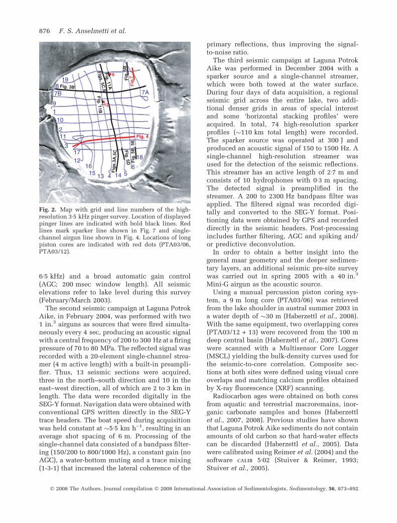
In February and March 2003, the subsurface ofLaguna Potrok Aike was investigated with a high-resolution 3Æ5 kHz seismic system deployed fromthe steel-hulled catamaran RV Lago Cardiel,which was used for all other consecutive seismicsurveys as well. The pinger instrument allows apenetration of several tens of metres with avertical resolution of less than 10 cm. The signalwas recorded digitally in the SEG-Y format. Theshot interval was 500 msec and cruising speedapproximately 6 km h)1. Positioning data wereobtained by a GPS system mounted directly onthe sender/receiver assembly. Over 100 km ofseismic lines were acquired, imaging the subsur-face of the lake with a dense grid of 10 east–westlines, eight north–south lines and some addi-tional lines in selected areas (Fig. 2). Average linespacing amounts to 250 m. Single-channel datawere processed by applying a bandpass filter (2 to
Seismic stratigraphy of Laguna Potrok Aike 875
� 2008 The Authors. Journal compilation � 2008 International Association of Sedimentologists, Sedimentology, 56, 873–892
6Æ5 kHz) and a broad automatic gain control(AGC; 200 msec window length). All seismicelevations refer to lake level during this survey(February/March 2003).
The second seismic campaign at Laguna PotrokAike, in February 2004, was performed with two1 in.3 airguns as sources that were fired simulta-neously every 4 sec, producing an acoustic signalwith a central frequency of 200 to 300 Hz at a firingpressure of 70 to 80 MPa. The reflected signal wasrecorded with a 20-element single-channel strea-mer (4 m active length) with a built-in preampli-fier. Thus, 13 seismic sections were acquired,three in the north–south direction and 10 in theeast–west direction, all of which are 2 to 3 km inlength. The data were recorded digitally in theSEG-Y format. Navigation data were obtained withconventional GPS written directly in the SEG-Ytrace headers. The boat speed during acquisitionwas held constant at �5Æ5 km h)1, resulting in anaverage shot spacing of 6 m. Processing of thesingle-channel data consisted of a bandpass filter-ing (150/200 to 800/1000 Hz), a constant gain (noAGC), a water-bottom muting and a trace mixing(1-3-1) that increased the lateral coherence of the
primary reflections, thus improving the signal-to-noise ratio.
The third seismic campaign at Laguna PotrokAike was performed in December 2004 with asparker source and a single-channel streamer,which were both towed at the water surface.During four days of data acquisition, a regionalseismic grid across the entire lake, two addi-tional denser grids in areas of special interestand some ‘horizontal stacking profiles’ wereacquired. In total, 74 high-resolution sparkerprofiles (�110 km total length) were recorded.The sparker source was operated at 300 J andproduced an acoustic signal of 150 to 1500 Hz. Asingle-channel high-resolution streamer wasused for the detection of the seismic reflections.This streamer has an active length of 2Æ7 m andconsists of 10 hydrophones with 0Æ3 m spacing.The detected signal is preamplified in thestreamer. A 200 to 2300 Hz bandpass filter wasapplied. The filtered signal was recorded digi-tally and converted to the SEG-Y format. Posi-tioning data were obtained by GPS and recordeddirectly in the seismic headers. Post-processingincludes further filtering, AGC and spiking and/or predictive deconvolution.
In order to obtain a better insight into thegeneral maar geometry and the deeper sedimen-tary layers, an additional seismic pre-site surveywas carried out in spring 2005 with a 40 in.3
Mini-G airgun as the acoustic source.Using a manual percussion piston coring sys-
tem, a 9 m long core (PTA03/06) was retrievedfrom the lake shoulder in austral summer 2003 ina water depth of �30 m (Haberzettl et al., 2008).With the same equipment, two overlapping cores(PTA03/12 + 13) were recovered from the 100 mdeep central basin (Haberzettl et al., 2007). Coreswere scanned with a Multisensor Core Logger(MSCL) yielding the bulk-density curves used forthe seismic-to-core correlation. Composite sec-tions at both sites were defined using visual coreoverlaps and matching calcium profiles obtainedby X-ray fluorescence (XRF) scanning.
Radiocarbon ages were obtained on both coresfrom aquatic and terrestrial macroremains, inor-ganic carbonate samples and bones (Haberzettlet al., 2007, 2008). Previous studies have shownthat Laguna Potrok Aike sediments do not containamounts of old carbon so that hard-water effectscan be discarded (Haberzettl et al., 2005). Datawere calibrated using Reimer et al. (2004) and thesoftware calib 5Æ02 (Stuiver & Reimer, 1993;Stuiver et al., 2005).
8
17
11 2
1 9
7B
4 1315 16
12
7A
19
6514
18
3
10
Fig. 11A
6
Fig
. 11B
Fig
s.3A
,5C
Fig
. 5B
, 5E
12
Fig. 3B
Fig
. 5B
Fig
. 5D
Figs. 5C,6
Fig
.7Fig. 4
Fig. 2. Map with grid and line numbers of the high-resolution 3Æ5 kHz pinger survey. Location of displayedpinger lines are indicated with bold black lines. Redlines mark sparker line shown in Fig. 7 and single-channel airgun line shown in Fig. 4. Locations of longpiston cores are indicated with red dots (PTA03/06,PTA03/12).
876 F. S. Anselmetti et al.
� 2008 The Authors. Journal compilation � 2008 International Association of Sedimentologists, Sedimentology, 56, 873–892
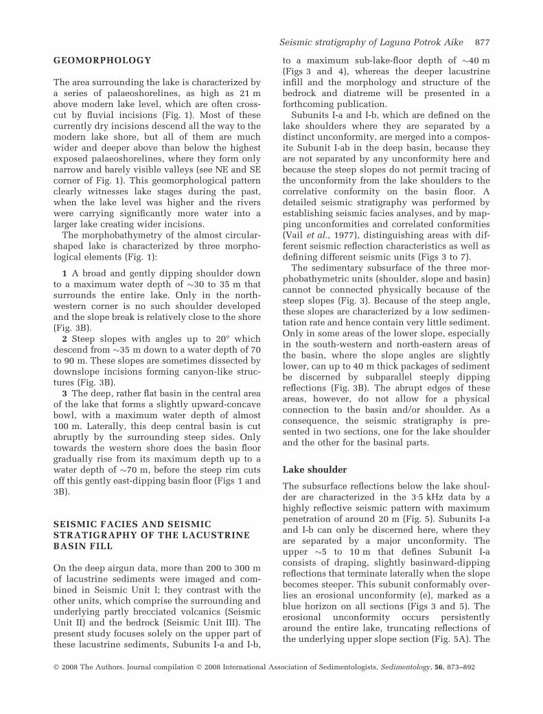
GEOMORPHOLOGY
The area surrounding the lake is characterized bya series of palaeoshorelines, as high as 21 mabove modern lake level, which are often cross-cut by fluvial incisions (Fig. 1). Most of thesecurrently dry incisions descend all the way to themodern lake shore, but all of them are muchwider and deeper above than below the highestexposed palaeoshorelines, where they form onlynarrow and barely visible valleys (see NE and SEcorner of Fig. 1). This geomorphological patternclearly witnesses lake stages during the past,when the lake level was higher and the riverswere carrying significantly more water into alarger lake creating wider incisions.
The morphobathymetry of the almost circular-shaped lake is characterized by three morpho-logical elements (Fig. 1):
1 A broad and gently dipping shoulder downto a maximum water depth of �30 to 35 m thatsurrounds the entire lake. Only in the north-western corner is no such shoulder developedand the slope break is relatively close to the shore(Fig. 3B).
2 Steep slopes with angles up to 20� whichdescend from �35 m down to a water depth of 70to 90 m. These slopes are sometimes dissected bydownslope incisions forming canyon-like struc-tures (Fig. 3B).
3 The deep, rather flat basin in the central areaof the lake that forms a slightly upward-concavebowl, with a maximum water depth of almost100 m. Laterally, this deep central basin is cutabruptly by the surrounding steep sides. Onlytowards the western shore does the basin floorgradually rise from its maximum depth up to awater depth of �70 m, before the steep rim cutsoff this gently east-dipping basin floor (Figs 1 and3B).
SEISMIC FACIES AND SEISMICSTRATIGRAPHY OF THE LACUSTRINEBASIN FILL
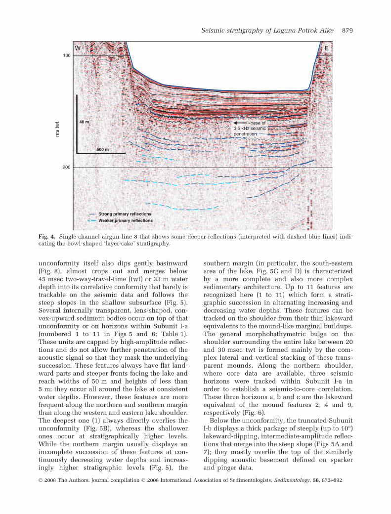
On the deep airgun data, more than 200 to 300 mof lacustrine sediments were imaged and com-bined in Seismic Unit I; they contrast with theother units, which comprise the surrounding andunderlying partly brecciated volcanics (SeismicUnit II) and the bedrock (Seismic Unit III). Thepresent study focuses solely on the upper part ofthese lacustrine sediments, Subunits I-a and I-b,
to a maximum sub-lake-floor depth of �40 m(Figs 3 and 4), whereas the deeper lacustrineinfill and the morphology and structure of thebedrock and diatreme will be presented in aforthcoming publication.
Subunits I-a and I-b, which are defined on thelake shoulders where they are separated by adistinct unconformity, are merged into a compos-ite Subunit I-ab in the deep basin, because theyare not separated by any unconformity here andbecause the steep slopes do not permit tracing ofthe unconformity from the lake shoulders to thecorrelative conformity on the basin floor. Adetailed seismic stratigraphy was performed byestablishing seismic facies analyses, and by map-ping unconformities and correlated conformities(Vail et al., 1977), distinguishing areas with dif-ferent seismic reflection characteristics as well asdefining different seismic units (Figs 3 to 7).
The sedimentary subsurface of the three mor-phobathymetric units (shoulder, slope and basin)cannot be connected physically because of thesteep slopes (Fig. 3). Because of the steep angle,these slopes are characterized by a low sedimen-tation rate and hence contain very little sediment.Only in some areas of the lower slope, especiallyin the south-western and north-eastern areas ofthe basin, where the slope angles are slightlylower, can up to 40 m thick packages of sedimentbe discerned by subparallel steeply dippingreflections (Fig. 3B). The abrupt edges of theseareas, however, do not allow for a physicalconnection to the basin and/or shoulder. As aconsequence, the seismic stratigraphy is pre-sented in two sections, one for the lake shoulderand the other for the basinal parts.
Lake shoulder
The subsurface reflections below the lake shoul-der are characterized in the 3Æ5 kHz data by ahighly reflective seismic pattern with maximumpenetration of around 20 m (Fig. 5). Subunits I-aand I-b can only be discerned here, where theyare separated by a major unconformity. Theupper �5 to 10 m that defines Subunit I-aconsists of draping, slightly basinward-dippingreflections that terminate laterally when the slopebecomes steeper. This subunit conformably over-lies an erosional unconformity (e), marked as ablue horizon on all sections (Figs 3 and 5). Theerosional unconformity occurs persistentlyaround the entire lake, truncating reflections ofthe underlying upper slope section (Fig. 5A). The
Seismic stratigraphy of Laguna Potrok Aike 877
� 2008 The Authors. Journal compilation � 2008 International Association of Sedimentologists, Sedimentology, 56, 873–892
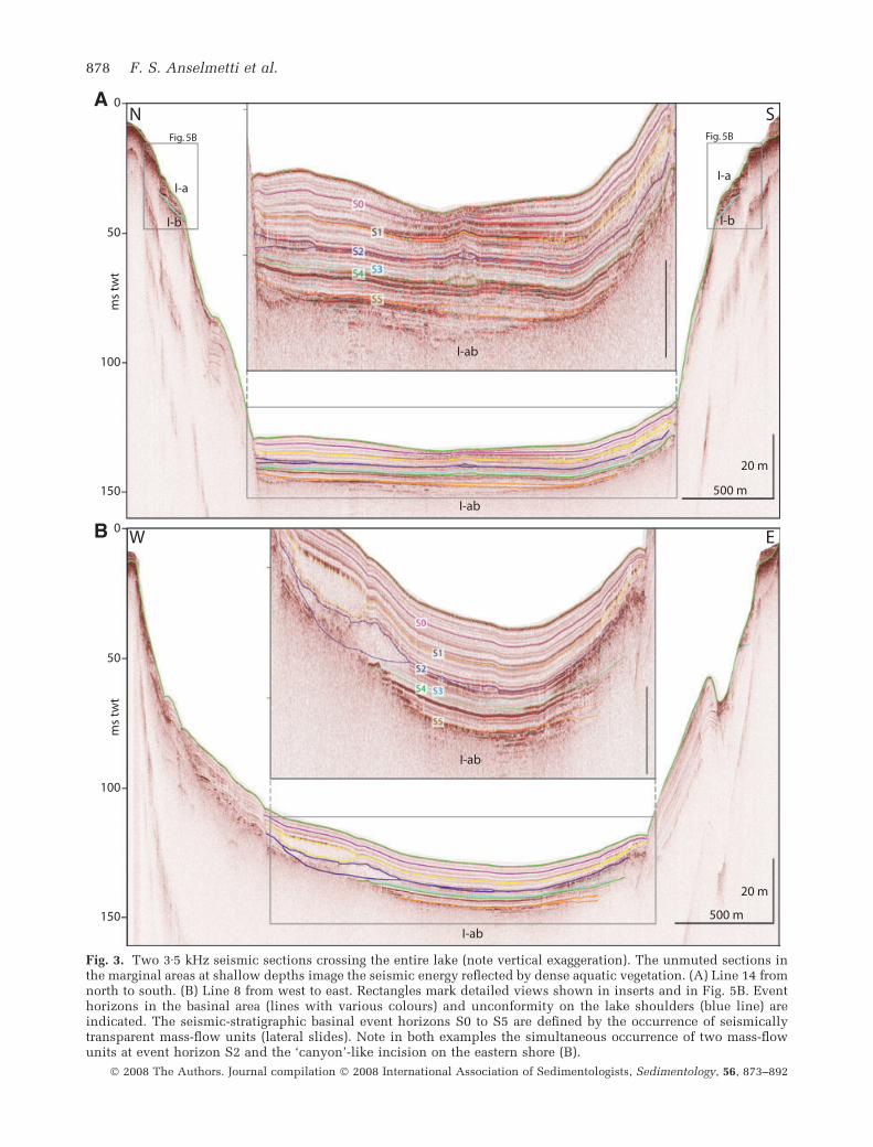
Fig. 3. Two 3Æ5 kHz seismic sections crossing the entire lake (note vertical exaggeration). The unmuted sections inthe marginal areas at shallow depths image the seismic energy reflected by dense aquatic vegetation. (A) Line 14 fromnorth to south. (B) Line 8 from west to east. Rectangles mark detailed views shown in inserts and in Fig. 5B. Eventhorizons in the basinal area (lines with various colours) and unconformity on the lake shoulders (blue line) areindicated. The seismic-stratigraphic basinal event horizons S0 to S5 are defined by the occurrence of seismicallytransparent mass-flow units (lateral slides). Note in both examples the simultaneous occurrence of two mass-flowunits at event horizon S2 and the ‘canyon’-like incision on the eastern shore (B).
878 F. S. Anselmetti et al.
� 2008 The Authors. Journal compilation � 2008 International Association of Sedimentologists, Sedimentology, 56, 873–892
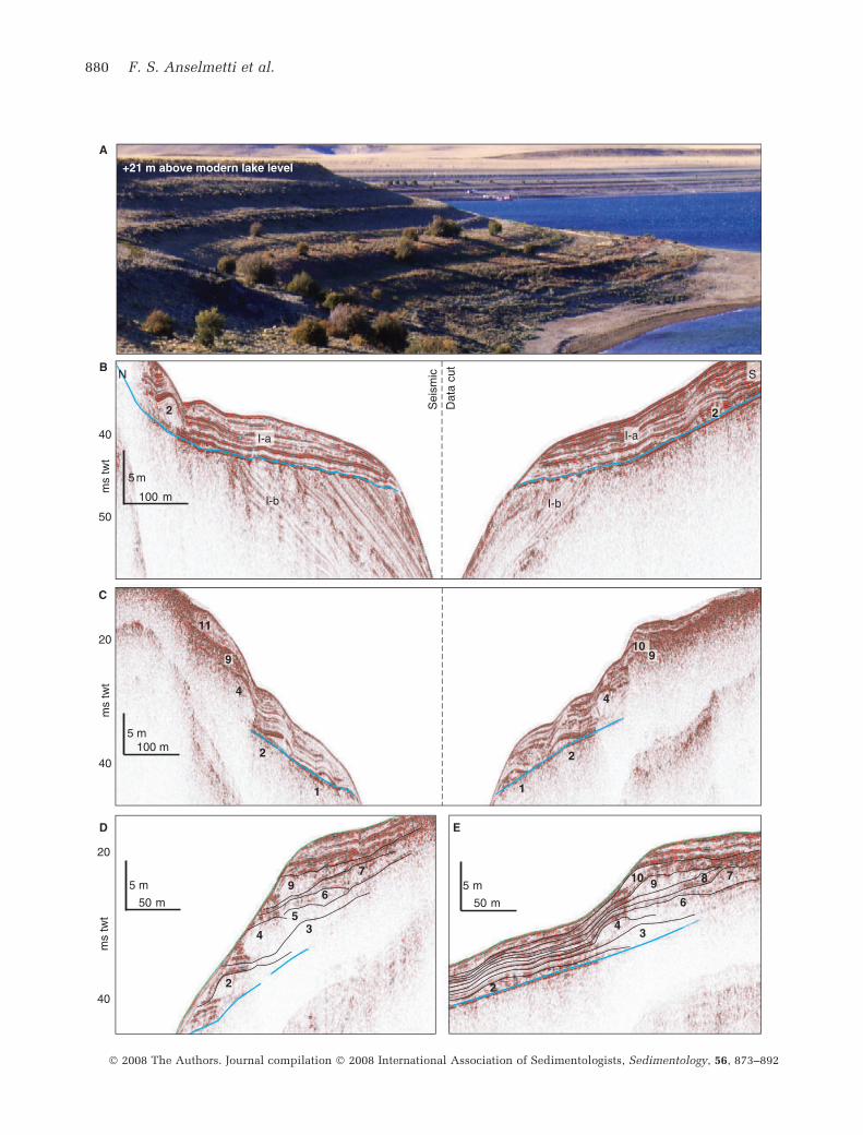
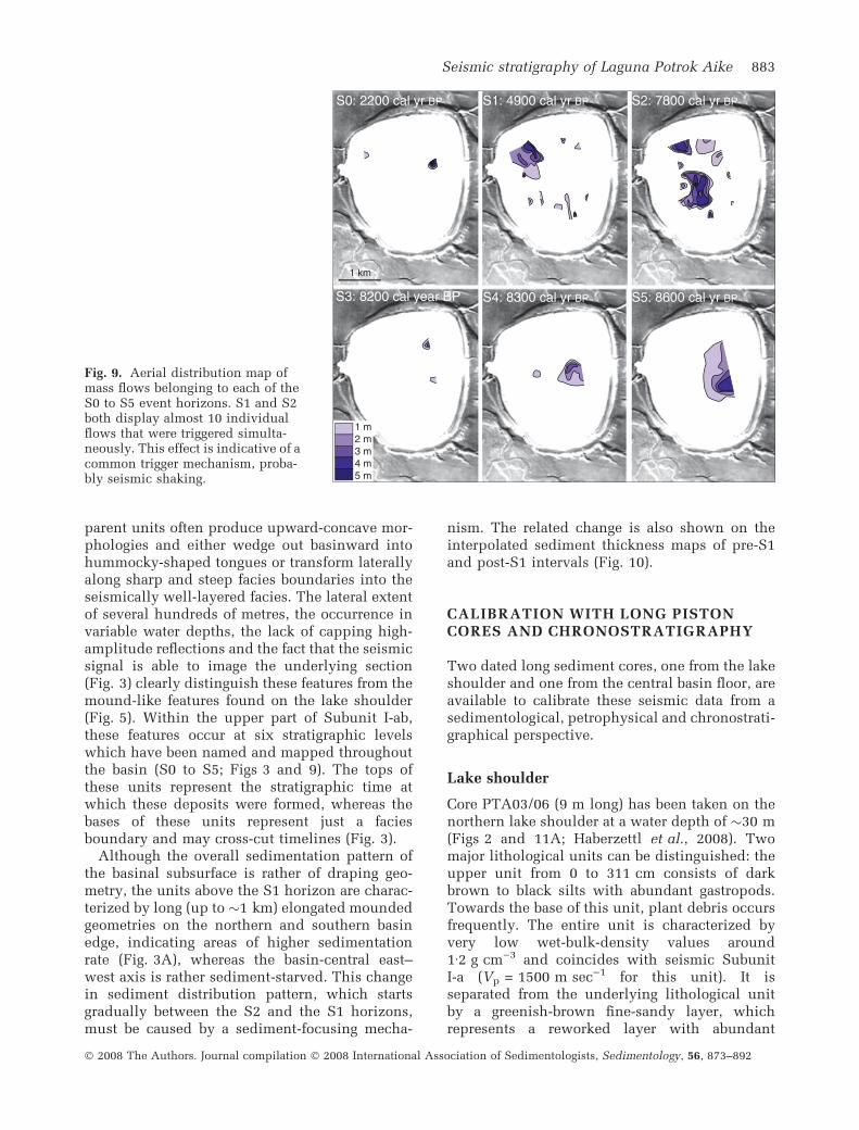
unconformity itself also dips gently basinward(Fig. 8), almost crops out and merges below45 msec two-way-travel-time (twt) or 33 m waterdepth into its correlative conformity that barely istrackable on the seismic data and follows thesteep slopes in the shallow subsurface (Fig. 5).Several internally transparent, lens-shaped, con-vex-upward sediment bodies occur on top of thatunconformity or on horizons within Subunit I-a(numbered 1 to 11 in Figs 5 and 6; Table 1).These units are capped by high-amplitude reflec-tions and do not allow further penetration of theacoustic signal so that they mask the underlyingsuccession. These features always have flat land-ward parts and steeper fronts facing the lake andreach widths of 50 m and heights of less than5 m; they occur all around the lake at consistentwater depths. However, these features are morefrequent along the northern and southern marginthan along the western and eastern lake shoulder.The deepest one (1) always directly overlies theunconformity (Fig. 5B), whereas the shallowerones occur at stratigraphically higher levels.While the northern margin usually displays anincomplete succession of these features at con-tinuously decreasing water depths and increas-ingly higher stratigraphic levels (Fig. 5), the
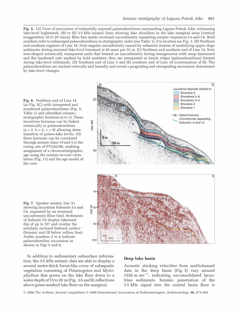
southern margin (in particular, the south-easternarea of the lake, Fig. 5C and D) is characterizedby a more complete and also more complexsedimentary architecture. Up to 11 features arerecognized here (1 to 11) which form a strati-graphic succession in alternating increasing anddecreasing water depths. These features can betracked on the shoulder from their thin lakewardequivalents to the mound-like marginal buildups.The general morphobathymetric bulge on theshoulder surrounding the entire lake between 20and 30 msec twt is formed mainly by the com-plex lateral and vertical stacking of these trans-parent mounds. Along the northern shoulder,where core data are available, three seismichorizons were tracked within Subunit I-a inorder to establish a seismic-to-core correlation.These three horizons a, b and c are the lakewardequivalent of the mound features 2, 4 and 9,respectively (Fig. 6).
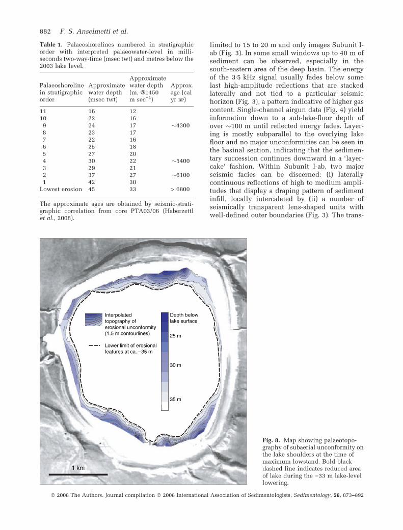
Below the unconformity, the truncated SubunitI-b displays a thick package of steeply (up to 10�)lakeward-dipping, intermediate-amplitude reflec-tions that merge into the steep slope (Figs 5A and7); they mostly overlie the top of the similarlydipping acoustic basement defined on sparkerand pinger data.
Strong primary reflections
Weaker primary reflections
W
500 m
40 m
100
200
ms
twt
E
~base of 3·5 kHz seismic penetration
Fig. 4. Single-channel airgun line 8 that shows some deeper reflections (interpreted with dashed blue lines) indi-cating the bowl-shaped ‘layer-cake’ stratigraphy.
Seismic stratigraphy of Laguna Potrok Aike 879
� 2008 The Authors. Journal compilation � 2008 International Association of Sedimentologists, Sedimentology, 56, 873–892
100 m
5 m
100 m 5 m
B
C
20
50
40
ms
twt
40
ms
twt
Sei
smic
Dat
a cu
t
I-b I-b
I-a I-a
2
2 2
1 1
4 4
11
2
5
4 3
2
9 7
6
2
3 4
6
7 8 9 10
20
40
ms
twt
50 m
5 m
10 9 9
50 m
5 m
N S
A
+21 m above modern lake level
D E
880 F. S. Anselmetti et al.
� 2008 The Authors. Journal compilation � 2008 International Association of Sedimentologists, Sedimentology, 56, 873–892
In addition to sedimentary subsurface informa-tion, the 3Æ5 kHz seismic data are able to display aseveral metre-thick forest-like cover of subaquaticvegetation consisting of Potamogeton and Myrio-phyllum that grows on the lake floor down to awater depth of15 to 20 m (Fig. 3A andB; reflectionsabove green-marked lake floor on the margins).
Deep lake basin
Acoustic stacking velocities from multichanneldata in the deep basin (Fig. 3) vary around1550 m sec)1, indicating unconsolidated lacus-trine sediments. Seismic penetration of the3Æ5 kHz signal into the central basin floor is
Fig. 5. (A) View of succession of subaerially exposed palaeoshorelines surrounding Laguna Potrok Aike, witnessinglake-level highstands. (B) to (E) 3Æ5 kHz seismic lines showing lake shoulders in the lake marginal areas (verticalexaggeration 10 to 20 times). Blue line marks erosional unconformity separating seismic sequences I-a and I-b. Boldnumbers refer to submerged palaeoshorelines in stratigraphic order (see Table 1). For location see Fig. 2. (B) Northernand southern segment of Line 18. Note angular unconformity caused by subaerial erosion of underlying upper slopesediments during maximal lake-level lowstand at 45 msec per 33 m. (C) Northern and southern end of Line 14. Notelens-shaped seismically transparent units that formed on unconformity during transgression with steep basinwardand flat landward side marked by bold numbers; they are interpreted as beach ridges (palaeoshorelines) formedduring lake-level stillstands. (D) Southern end of Line 5 and (E) southern end of Line 18 (continuation of B): Thepalaeoshorelines are stacked vertically and laterally and reveal a prograding and retrograding succession determinedby lake-level changes.
4
9
2
1
50 m
5 m
N S
40
20
ms
twt
Lacustrine deposits related to:Shoreline 9 Shorelines 5–8Shorelines 3–4Shoreline 2 Shoreline 1
Dated horizonsUnconformity separatingSubunits I-a and I-b
c
c
ba
Fig. 6. Northern end of Line 14(as Fig. 5C) with interpreted andnumbered palaeoshorelines (Fig. 5;Table 1) and identified seismic-stratigraphic horizons (a to c). Theselacustrine horizons can be linkedseismically to palaeoshorelines(a = 2, b = 4, c = 9) allowing deter-mination of palaeo-lake levels. Allthree horizons can be correlatedthrough seismic lines 19 and 5 to thecoring site of PTA03/06, enablingassignment of a chronostratigraphicage using the seismic-to-core corre-lation (Fig. 11) and the age model ofthe core.
80
60
40
mst
wt
100
N S
50 m10 m
I-a
I-b
III
2
3 4
Fig. 7. Sparker seismic line 51showing lacustrine Subunits I-a andI-b, separated by an erosionalunconformity (blue line). Sedimentsof Subunit I-b display lakewarddip of up to 10� and overlay thesimilarly inclined bedrock surface(Seismic unit III below yellow line).Arabic numbers 2 to 4 indicatepalaeoshoreline succession asshown in Figs 5 and 6.
Seismic stratigraphy of Laguna Potrok Aike 881
� 2008 The Authors. Journal compilation � 2008 International Association of Sedimentologists, Sedimentology, 56, 873–892
limited to 15 to 20 m and only images Subunit I-ab (Fig. 3). In some small windows up to 40 m ofsediment can be observed, especially in thesouth-eastern area of the deep basin. The energyof the 3Æ5 kHz signal usually fades below somelast high-amplitude reflections that are stackedlaterally and not tied to a particular seismichorizon (Fig. 3), a pattern indicative of higher gascontent. Single-channel airgun data (Fig. 4) yieldinformation down to a sub-lake-floor depth ofover �100 m until reflected energy fades. Layer-ing is mostly subparallel to the overlying lakefloor and no major unconformities can be seen inthe basinal section, indicating that the sedimen-tary succession continues downward in a ‘layer-cake’ fashion. Within Subunit I-ab, two majorseismic facies can be discerned: (i) laterallycontinuous reflections of high to medium ampli-tudes that display a draping pattern of sedimentinfill, locally intercalated by (ii) a number ofseismically transparent lens-shaped units withwell-defined outer boundaries (Fig. 3). The trans-
Interpolatedtopography oferosional unconformity(1.5 m contourlines)
Lower limit of erosionalfeatures at ca. –35 m
30 m
35 m
Depth belowlake surface
25 m
1 km
Fig. 8. Map showing palaeotopo-graphy of subaerial unconformity onthe lake shoulders at the time ofmaximum lowstand. Bold-blackdashed line indicates reduced areaof lake during the )33 m lake-levellowering.
Table 1. Palaeoshorelines numbered in stratigraphicorder with interpreted palaeowater-level in milli-seconds two-way-time (msec twt) and metres below the2003 lake level.
Palaeoshorelinein stratigraphicorder
Approximatewater depth(msec twt)
Approximatewater depth(m, @1450m sec)1)
Approx.age (calyr bp)
11 16 1210 22 169 24 17 �43008 23 177 22 166 25 185 27 204 30 22 �54003 29 212 37 27 �61001 42 30
Lowest erosion 45 33 > 6800
The approximate ages are obtained by seismic-strati-graphic correlation from core PTA03/06 (Haberzettlet al., 2008).
882 F. S. Anselmetti et al.
� 2008 The Authors. Journal compilation � 2008 International Association of Sedimentologists, Sedimentology, 56, 873–892
parent units often produce upward-concave mor-phologies and either wedge out basinward intohummocky-shaped tongues or transform laterallyalong sharp and steep facies boundaries into theseismically well-layered facies. The lateral extentof several hundreds of metres, the occurrence invariable water depths, the lack of capping high-amplitude reflections and the fact that the seismicsignal is able to image the underlying section(Fig. 3) clearly distinguish these features from themound-like features found on the lake shoulder(Fig. 5). Within the upper part of Subunit I-ab,these features occur at six stratigraphic levelswhich have been named and mapped throughoutthe basin (S0 to S5; Figs 3 and 9). The tops ofthese units represent the stratigraphic time atwhich these deposits were formed, whereas thebases of these units represent just a faciesboundary and may cross-cut timelines (Fig. 3).
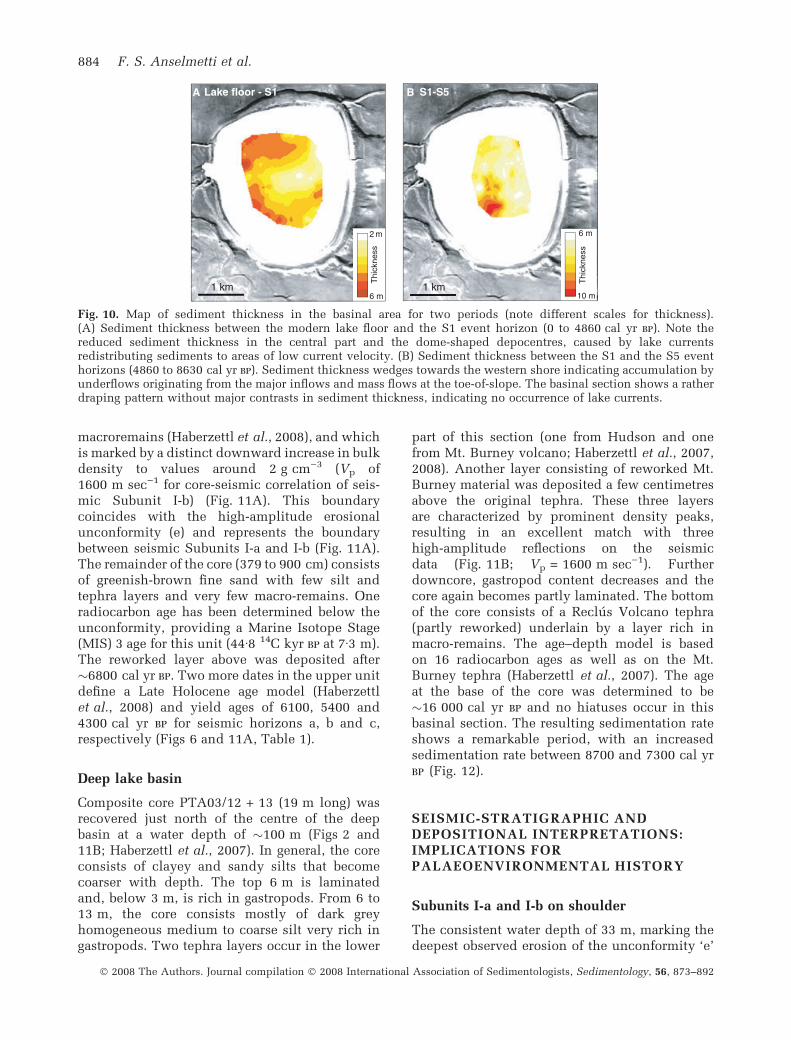
Although the overall sedimentation pattern ofthe basinal subsurface is rather of draping geo-metry, the units above the S1 horizon are charac-terized by long (up to �1 km) elongated moundedgeometries on the northern and southern basinedge, indicating areas of higher sedimentationrate (Fig. 3A), whereas the basin-central east–west axis is rather sediment-starved. This changein sediment distribution pattern, which startsgradually between the S2 and the S1 horizons,must be caused by a sediment-focusing mecha-
nism. The related change is also shown on theinterpolated sediment thickness maps of pre-S1and post-S1 intervals (Fig. 10).
CALIBRATION WITH LONG PISTONCORES AND CHRONOSTRATIGRAPHY
Two dated long sediment cores, one from the lakeshoulder and one from the central basin floor, areavailable to calibrate these seismic data from asedimentological, petrophysical and chronostrati-graphical perspective.
Lake shoulder
Core PTA03/06 (9 m long) has been taken on thenorthern lake shoulder at a water depth of �30 m(Figs 2 and 11A; Haberzettl et al., 2008). Twomajor lithological units can be distinguished: theupper unit from 0 to 311 cm consists of darkbrown to black silts with abundant gastropods.Towards the base of this unit, plant debris occursfrequently. The entire unit is characterized byvery low wet-bulk-density values around1Æ2 g cm)3 and coincides with seismic SubunitI-a (Vp = 1500 m sec)1 for this unit). It isseparated from the underlying lithological unitby a greenish-brown fine-sandy layer, whichrepresents a reworked layer with abundant
S0: 2200 cal yr BP
S4: 8300 cal yr BP
S2: 7800 cal yr BP
S5: 8600 cal yr BPS3: 8200 cal year BP
S1: 4900 cal yr BP
1 m 2 m 3 m 4 m 5 m
1 km
Fig. 9. Aerial distribution map ofmass flows belonging to each of theS0 to S5 event horizons. S1 and S2both display almost 10 individualflows that were triggered simulta-neously. This effect is indicative of acommon trigger mechanism, proba-bly seismic shaking.
Seismic stratigraphy of Laguna Potrok Aike 883
� 2008 The Authors. Journal compilation � 2008 International Association of Sedimentologists, Sedimentology, 56, 873–892
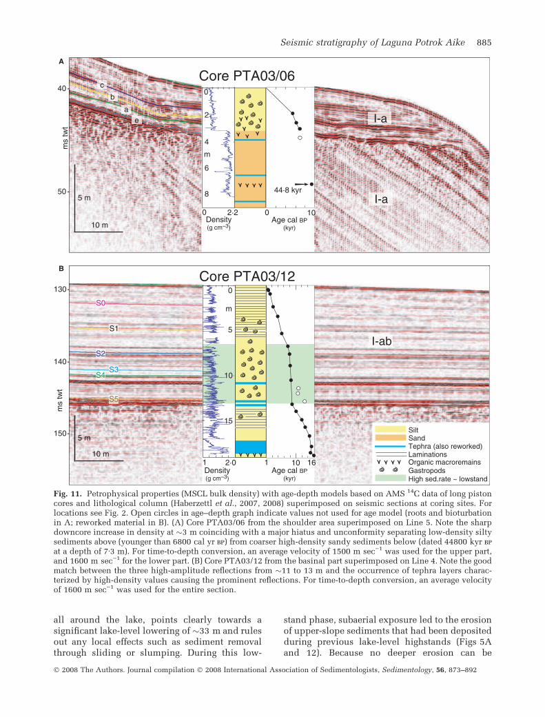
macroremains (Haberzettl et al., 2008), and whichis marked by a distinct downward increase in bulkdensity to values around 2 g cm)3 (Vp of1600 m sec)1 for core-seismic correlation of seis-mic Subunit I-b) (Fig. 11A). This boundarycoincides with the high-amplitude erosionalunconformity (e) and represents the boundarybetween seismic Subunits I-a and I-b (Fig. 11A).The remainder of the core (379 to 900 cm) consistsof greenish-brown fine sand with few silt andtephra layers and very few macro-remains. Oneradiocarbon age has been determined below theunconformity, providing a Marine Isotope Stage(MIS) 3 age for this unit (44Æ8 14C kyr bp at 7Æ3 m).The reworked layer above was deposited after�6800 cal yr bp. Two more dates in the upper unitdefine a Late Holocene age model (Haberzettlet al., 2008) and yield ages of 6100, 5400 and4300 cal yr bp for seismic horizons a, b and c,respectively (Figs 6 and 11A, Table 1).
Deep lake basin
Composite core PTA03/12 + 13 (19 m long) wasrecovered just north of the centre of the deepbasin at a water depth of �100 m (Figs 2 and11B; Haberzettl et al., 2007). In general, the coreconsists of clayey and sandy silts that becomecoarser with depth. The top 6 m is laminatedand, below 3 m, is rich in gastropods. From 6 to13 m, the core consists mostly of dark greyhomogeneous medium to coarse silt very rich ingastropods. Two tephra layers occur in the lower
part of this section (one from Hudson and onefrom Mt. Burney volcano; Haberzettl et al., 2007,2008). Another layer consisting of reworked Mt.Burney material was deposited a few centimetresabove the original tephra. These three layersare characterized by prominent density peaks,resulting in an excellent match with threehigh-amplitude reflections on the seismicdata (Fig. 11B; Vp = 1600 m sec)1). Furtherdowncore, gastropod content decreases and thecore again becomes partly laminated. The bottomof the core consists of a Reclus Volcano tephra(partly reworked) underlain by a layer rich inmacro-remains. The age–depth model is basedon 16 radiocarbon ages as well as on the Mt.Burney tephra (Haberzettl et al., 2007). The ageat the base of the core was determined to be�16 000 cal yr bp and no hiatuses occur in thisbasinal section. The resulting sedimentation rateshows a remarkable period, with an increasedsedimentation rate between 8700 and 7300 cal yrbp (Fig. 12).
SEISMIC-STRATIGRAPHIC ANDDEPOSITIONAL INTERPRETATIONS:IMPLICATIONS FORPALAEOENVIRONMENTAL HISTORY
Subunits I-a and I-b on shoulder
The consistent water depth of 33 m, marking thedeepest observed erosion of the unconformity ‘e’
2 m
6 m
Thi
ckne
ss
6 m
10 m
Lake floor - S1 BA S1-S5
1 km 1 km
Thi
ckne
ss
Fig. 10. Map of sediment thickness in the basinal area for two periods (note different scales for thickness).(A) Sediment thickness between the modern lake floor and the S1 event horizon (0 to 4860 cal yr bp). Note thereduced sediment thickness in the central part and the dome-shaped depocentres, caused by lake currentsredistributing sediments to areas of low current velocity. (B) Sediment thickness between the S1 and the S5 eventhorizons (4860 to 8630 cal yr bp). Sediment thickness wedges towards the western shore indicating accumulation byunderflows originating from the major inflows and mass flows at the toe-of-slope. The basinal section shows a ratherdraping pattern without major contrasts in sediment thickness, indicating no occurrence of lake currents.
884 F. S. Anselmetti et al.
� 2008 The Authors. Journal compilation � 2008 International Association of Sedimentologists, Sedimentology, 56, 873–892
all around the lake, points clearly towards asignificant lake-level lowering of �33 m and rulesout any local effects such as sediment removalthrough sliding or slumping. During this low-
stand phase, subaerial exposure led to the erosionof upper-slope sediments that had been depositedduring previous lake-level highstands (Figs 5Aand 12). Because no deeper erosion can be
50 -
40
A
B
-
ms
twt
10 m
5 m
140 -
130 -
ms
twt
150 - 5 m
S0
S1
S2
S3S4
S5
0 2·2Density(g cm–3)
1 2·0 Density (g cm–3)
Core PTA03/06
Core PTA03/12
15
10
5
0
m
Silt Sand Tephra (also reworked) Laminations Organic macroremains Gastropods
8
6
4
m
2
0
10 m
I-a
I-ab
ea
b
c
1 16 10
0 10Age cal BP
(kyr)
Age cal BP(kyr)
44·8 kyrI-a
High sed.rate ~ lowstand
Fig. 11. Petrophysical properties (MSCL bulk density) with age-depth models based on AMS 14C data of long pistoncores and lithological column (Haberzettl et al., 2007, 2008) superimposed on seismic sections at coring sites. Forlocations see Fig. 2. Open circles in age–depth graph indicate values not used for age model (roots and bioturbationin A; reworked material in B). (A) Core PTA03/06 from the shoulder area superimposed on Line 5. Note the sharpdowncore increase in density at �3 m coinciding with a major hiatus and unconformity separating low-density siltysediments above (younger than 6800 cal yr bp) from coarser high-density sandy sediments below (dated 44800 kyr bp
at a depth of 7Æ3 m). For time-to-depth conversion, an average velocity of 1500 m sec)1 was used for the upper part,and 1600 m sec)1 for the lower part. (B) Core PTA03/12 from the basinal part superimposed on Line 4. Note the goodmatch between the three high-amplitude reflections from �11 to 13 m and the occurrence of tephra layers charac-terized by high-density values causing the prominent reflections. For time-to-depth conversion, an average velocityof 1600 m sec)1 was used for the entire section.
Seismic stratigraphy of Laguna Potrok Aike 885
� 2008 The Authors. Journal compilation � 2008 International Association of Sedimentologists, Sedimentology, 56, 873–892
observed, it is certain that lake level did not fallbeyond this depth and that Laguna Potrok Aikenever fell dry, at least during the more recenthistory of more than 45 kyr (minimal age ofSubunit I-b sediments). During the time of lowlake level, the exposed sediments that todayunderlie the unconformity formed a gently dip-ping lake shore, with erosion being deepest closeto, or even just below, lake level, where waveaction is most efficient. This effect is shown by
the interpolated morphology of the unconformitythat shows the extent of the palaeolake and thetopography of the exposed bowl-shaped (alwayslakeward-dipping) coastal area (Fig. 8).
After this period of low lake level, a transgres-sion was initiated that flooded the shore along theunconformity so that the erosional surface be-came conformably overlain by sediments of theyounger Subunit I-a. The lens-shaped seismicallytransparent units within Subunit I-a that were
0 m
–40 m
–30 m
–20 m
–10 m
+20 m
+10 m
Lake
leve
l rel
ativ
e to
200
3
44.8kyrBP
–50 m04 2 167
54
3
1
2
8 9
11
1076
e
Approx. dated(core PTA03/06 andseismic strat.correlation )
Interpolated age
Transgression
Forced regression
c
b
a
a
810 9
S0S1S2S3S4S5
Increasedbasinalsedimen-tationrate
?
Episodes ofmass movements
Bas
inal
sed
. rat
e(m
m y
ear–1
)
0
5
10
?
Lake over flow + 21 m
Lake currents (drift deposits)
Unc
onfo
rmity
Animal bones
Age (kyr, cal BP)
Potential frame toextend lake level curve
5 3
Fig. 12. Comparison of onset of drift deposition (lake currents), basinal sedimentation rates (Haberzettl et al., 2007),occurrence of lateral mass-flow events (above) and lake-level fluctuations based on palaeoshoreline reconstructions(below). Circles indicate palaeoshorelines elevations and dates. Numbers under circles refer to the chronologicalorder of shorelines mapped on the seismic data. The left edge of the plot is on an expanded time scale toaccommodate for the 44Æ8 kyr bp date. Note the dramatically increased sedimentation rate during a lake-level low-ering that exposes and erodes lake sediments on the lake shoulders. This event charges slopes rapidly so that itcoincides with a series of lateral mass flows.
886 F. S. Anselmetti et al.
� 2008 The Authors. Journal compilation � 2008 International Association of Sedimentologists, Sedimentology, 56, 873–892
formed on top of the unconformity and that occuraround the lake at consistent depths are inter-preted as palaeoshorelines, which formed duringslowdowns or stillstands within the overall trans-gression. This interpretation is supported both bythe consistent depths at which these featuresoccur and by their morphologies which aresimilar to those of lacustrine shorelines in otherclosed lake basins (Thompson, 1992; Adams &Wesnousky, 1998; Ibbeken & Warnke, 2000;Komatsu et al., 2001; Gilli et al., 2005a; Ansel-metti et al., 2006). The characteristic shape ofthese features, with a steep lakeward-facing sideand a gentle-to-flat landward portion is verytypical of beach ridges marking palaeoshorelinesthat can develop only when water level remainsstable for a certain period. Furthermore, animplication of the good preservation of thesepalaeoshorelines is that the lake-level rises inbetween phases of palaeoshoreline developmentmust have happened rather quickly so that pre-viously deposited shorelines were not erodedstraight away (Gilli et al., 2005a, and referencestherein). The complete succession of palaeoshore-lines in the south-eastern part of the lake basin(Fig. 5C and D) allows a detailed reconstructionof lake-level fluctuations. These 11 units arestratigraphically stacked and mark a temporalsuccession of formation levels, to which palaeo-lake-level positions can be assigned. Such asuccession is reminiscent of marine coastalsequences that are influenced by sea-level fluctu-ations (Posamentier & Allen, 1999; Rabineauet al., 2006). Depending on the accommodationspace, which is controlled by sedimentation rateand water-level fluctuations (ignoring in this casesubsidence rate, because time span is short andPotrok Aike is a closed basin), the 11 palaeolake-level indicators define a curve characterized byhigher-order transgressions and regressions.While the successions from the end of theunconformity ‘e’ to 3, from 4 to 7, and from 10to 11 reflect increasing lake levels (transgres-sions), the transitions 3 to 4 and especially 7 to 10represent slightly decreasing lake levels, duringwhich the shoreline was forced to move out anddown towards the basin centre (Figs 5C, D and12), as described in the marine realm by the term‘forced regression’ (Hunt & Tucker, 1992; Posa-mentier & Allen, 1999; Plint & Nummedal, 2000).The south-eastern area, where these shorelinesare best developed, lies just in front of the largestfluvial incision surrounding the lake (Fig. 1),documenting that the shorelines in this areamight also be delta deposits, which were fed
from a fluvial point source and became remobi-lized through wind-driven longshore currentsfeeding the laterally occurring beach ridges.
This succession of palaeoshoreline migrationsdefining the lake-level curve following the lake-level lowstand can be dated using the seismicstratigraphy that was calibrated by the availableshoulder core from the northern margin of thelake (Figs 6 and 11A). The three dated horizons a,b and c (see above) can be connected seismicallyto the shorelines 2, 4 and 9, respectively, whichenables the reconstructed lake-level curve to befixed at three temporal tie points (Fig. 12). Theages of the remaining palaeoshorelines wereinterpolated linearly between these fix points,and the youngest section was completed with adate from a shoreline occurring at +9 m above the2003 level, where a horse and guanaco skeletonallowed an age assignment to the �18th/19thCentury (i.e. Little Ice Age, Fig. 12; Haberzettlet al., 2005). Between the last shoreline (11) andthe +9 m level, the lake-level curve currently isnot constrained. However, the possibility of thelake level falling below �)12 m (orange area inFig. 12) can be excluded because no youngershoreline at or below this depth is observed, andthe older shorelines are covered by a thickundisturbed package of shoreline-distal depositslacking erosional features (Fig. 5C and D).
The resulting calibrated lake-level curve re-flects the stepwise P/E changes during the LateHolocene. The transgressions between shorelines4 to 7 and 10 to 11 were confirmed independentlyby geochemical proxies of the deep-water corethat displayed moist periods around 4800 andfrom 3900 to 3700 cal yr bp, respectively (Haber-zettl et al., 2007). The two periods of forcedshoreline regressions between �5800 and 5400and from �4700 to 4000 cal yr bp point towardsreduced P/E ratios at that time, documenting afluctuating evolution of the hydrological balanceduring the Holocene.
Subunit I-b always appears as a thick 10�lakeward-dipping sediment pile that covers thebedrock substrate. These reflections occasionallyshow some disturbed layering possibly due todownslope mass movements. Core PTA03/06indicates that Subunit I-b is dominated by coarsergrain-size compared with Subunit I-a above(Fig. 11B). Because these tilted layers occur allaround the lake, a delta origin due to a riverinflow can be excluded. These sediment particlesrather derive from enhanced fluvial or possiblyaeolian input at times of higher lake levels(possibly at the + 21 m overflow level) and
Seismic stratigraphy of Laguna Potrok Aike 887
� 2008 The Authors. Journal compilation � 2008 International Association of Sedimentologists, Sedimentology, 56, 873–892
became redistributed all around the lakeshoulders.
Subunit I-ab in the basin
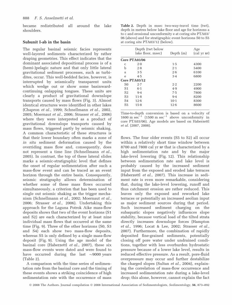
The regular basinal seismic facies representswell-layered sediments characterized by ratherdraping geometries. This effect indicates that thedominant associated depositional process is of a(hemi-)pelagic nature and that only little lateralgravitational sediment processes, such as turbi-dites, occur. This well-bedded facies, however, isinterrupted by seismically transparent unitswhich wedge out or show some basinward-continuing onlapping tongues. These units areclearly a product of gravitational downslopetransports caused by mass flows (Fig. 3). Almostidentical structures were identified in other lakes(Chapron et al., 1999; Schnellmann et al., 2002,2005; Moernaut et al., 2006; Strasser et al., 2006)where they were interpreted as a product ofgravitational downslope transports caused bymass flows, triggered partly by seismic shaking.A common characteristic of these structures isthat their lower boundary often marks a zone ofin situ sediment deformation caused by theoverriding mass flow and, consequently, doesnot represent a time line (Schnellmann et al.,2005). In contrast, the top of these lateral slidesmarks a seismic-stratigraphic level that definesthe onset of regular sedimentation after such amass-flow event and can be traced as an eventhorizon through the entire basin. Consequently,seismic stratigraphy allows determination ofwhether some of these mass flows occurredsimultaneously, a criterion that has been used tosingle out seismic shaking as the trigger mecha-nism (Schnellmann et al., 2002; Moernaut et al.,2006; Strasser et al., 2006). Undertaking thisapproach for the Laguna Potrok Aike mass-flowdeposits shows that two of the event horizons (S1and S2) are each characterized by at least nineindividual mass flows that occurred at the sametime (Fig. 9). Three of the other horizons (S0, S3and S4) each show two mass-flow deposits,whereas S5 is only defined by a single mass-flowdeposit (Fig. 9). Using the age model of thebasinal core (Haberzettl et al., 2007), these sixmass-flow events were dated and were found tohave occurred during the last �9000 years(Table 2).
A comparison with the time series of sedimen-tation rate from the basinal core and the timing ofthese events shows a striking coincidence of highsedimentation rate with the occurrence of mass
flows. The four older events (S5 to S2) all occurwithin a relatively short time window between8700 and 7800 cal yr bp that is characterized by ahigh sedimentation rate and by the majorlake-level lowering (Fig. 12). This relationshipbetween sedimentation rate and lake level isprobably caused by the increased sedimentinput from the exposed and eroded lake terraces(Haberzettl et al., 2007). This increase in sedi-ment rate is even more remarkable, consideringthat, during the lake-level lowering, runoff andthus catchment erosion are rather reduced. Thisleaves only the exposed and reworked laketerraces or potentially an increased aeolian inputas major sediment sources during that period.Such increased sediment charging on thesubaquatic slopes negatively influences slopestability, because vertical load of the tilted stratadirectly increases downslope forces (Hamptonet al., 1996; Locat & Lee, 2002; Strasser et al.,2007). Furthermore, the combination of rapidlydeposited fine-grained sediments, potentiallyclosing off pore water under undrained condi-tions, together with less overburden hydrostaticpressure because of a lower lake level, results inreduced effective pressure. As a result, pore-fluidoverpressure may occur and further destabilizethe charged slopes (Sultan et al., 2004), explain-ing the correlation of mass-flow occurrence andincreased sedimentation rate during a lake-leveldrop; this alone, however, cannot explain the fact
Table 2. Depth in msec two-way-travel time (twt),depth in metres below lake floor and age for horizons ato c and erosional unconformity e at coring site PTA03/06 (above) and for stratigraphic event horizons S0 to S5at coring site PTA03/12 (below).
Depth (twt belowlake floor, msec) Depth (m)
Age(cal yr bp)
Core PTA03/06c 2Æ0 1Æ5 4300b 2Æ8 2Æ1 5400a 3Æ5 2Æ6 6100e 4Æ5 3Æ4 6800
Core PTA03/12S0 2Æ7 2Æ2 2200S1 6Æ1 4Æ9 4900S2 9Æ4 7Æ5 7800S3 11Æ8 9Æ4 8200S4 12Æ6 10Æ1 8300S5 15Æ8 12Æ6 8600
Time-to-depth conversion is based on a velocity of1600 m sec)1 (1500 m sec)1 above unconformity incore PTA03/06). Age models are based on Haberzettlet al. (2007, 2008).
888 F. S. Anselmetti et al.
� 2008 The Authors. Journal compilation � 2008 International Association of Sedimentologists, Sedimentology, 56, 873–892
that S2 and S1 are comprised of multiple massflows. For these two cases, seismic shaking, asdiscussed above, is the most plausible triggermechanism. The S1 event, in particular, occur-ring around 4900 cal yr bp under regular sedi-mentation conditions, was triggered probably by apalaeoearthquake. Previous studies have shownthat basinwide sliding of lateral slopes usuallyrequires a local intensity (European MacroseismicScale) of �7 (Monecke et al., 2004). For S2, thisintensity might be lower because it happenedduring the period of generally unfavourableslope-stability conditions, so that less seismicacceleration might have been required to triggerthe large number of simultaneous slides.
The sediment mounds in the northern andsouthern areas of the basin floor, and the sedi-ment-starved east–west axial through in the cen-tral basin (Figs 3A and 10), developed sometimebetween the S2 and the S1 horizon (i.e. �6000 calyr bp). Such a pattern requires a depositionalmechanism that focuses sediments in depo-centres while keeping other areas under acondensed sedimentation regime. Such mound-like features are attributed usually to drift orcurrent-controlled deposits: slower currentscause increased deposition of suspendedparticles, whereas higher current velocities resultin a higher transport potential and lower sedi-mentation rates. The basinal sediment corePTA03/12 + 13 is located just at the southernmargin of the northern drift mound (Figs 2 and10), where no anomaly in the sedimentation ratescan be observed (Fig. 12). The observed pattern inLaguna Potrok Aike is highly reminiscent ofsediment geometries found in Lago Cardiel (Pat-agonia 49�; Gilli et al., 2001, 2005a,b; Markgrafet al., 2003), where similar deposits have beeninterpreted to be the result of increasing windstress because of a change in the strength of theWesterlies at that latitude. In a similar fashion,drift-influenced sediment geometries in LagunaPotrok Aike would require nucleation of strongcurrents which, considering the extreme windregime of today at the Laguna Potrok Aikelocation with mean monthly wind speeds of9 m sec)1 during early summer (Endlicher,1993; Baruth et al., 1998), would not be surpris-ing. The fact that the lowest sedimentation ratesoccur in the centre of the lake could imply notonly a single cell of a lake current but a wind-driven double convection cell with a central east-directed flow through the middle of the lake andmarginal west-directed backflows, as observedalso in other comparable lakes (Gilli et al., 2005b
and references therein). Alternatively, wind-induced surface stress could also create a verticalconvection cell, as water moving to the easttriggers a plunging current that causes thereduced sedimentation rate in the east–westcentral basinal axis (Fig. 10A) possibly linkedwith an upwelling at the western shore. In anycase, current measurements would be required toprove such a lake circulation pattern. Thesesediment geometries, the interpreted onset ofwind-driven lake currents and the related changein wind regime indicate a mid-Holocene strength-ening of the Westerlies in the area after �6000 calyr bp. This observation matches the timing ofwind strengthening postulated for Lago Cardiel 3�to the north (after 6800 cal yr bp), also on the basisof drift deposits (Gilli et al., 2005b). However, thepresented timing of wind strengthening is about3000 years later than what was postulated on thebasis of the Laguna Potrok Aike pollen record,which showed a change at 9200 cal yr bp (Mayret al., 2007). This discrepancy can be caused by ahigher sensitivity of the pollen record to a moregentle increase of the Westerlies, while the moreor less simultaneous triggering of lake currents forLaguna Potrok Aike and in Lago Cardiel mightrequire a certain minimal threshold in windspeed that was reached only later in the windhistory of southern Patagonia.
The deeper basinal sections appear to be similarin nature to the shallow subsurface (Fig. 4). Theoverall stratigraphic pattern of subparallel reflec-tions with only the occasional occurrence ofseismically transparent units representing localmass movements, together with the absence ofmajor unconformities, point towards the highpotential of these sediments to contain a contin-uous and undisturbed palaeoenvironmentalarchive which potentially dates back to thevolcanic creation of this maar lake.
SUMMARY AND CONCLUSIONS
The presented seismic-stratigraphic study of thebasin fill of Laguna Potrok Aike, calibrated withtwo long sediment cores, enables reconstructionof a series of palaeoenvironmental events thatoccurred during the Late Quaternary in Pata-gonia at 52�S. Quantified lake-level fluctuationsof this closed basin reflect past changes inprecipitation/evaporation ratio. Periods of en-hanced sublacustrine mass movements arelinked to changes in sedimentation rates andpotentially to palaeoseismic triggers. Sediment
Seismic stratigraphy of Laguna Potrok Aike 889
� 2008 The Authors. Journal compilation � 2008 International Association of Sedimentologists, Sedimentology, 56, 873–892
geometries reflect changes in lake currents thatare controlled by fluctuations in the SouthernWesterlies. All these events can be tracked inthe seismic data and are summarized in thefollowing event chronology:
1 A thick package of lake sediments can beimaged using seismic methods at the bottom ofLaguna Potrok Aike, reflecting the potential of thelake as a palaeoenvironmental archive spanningseveral glacial–interglacial cycles. This extendedand potentially continuous continental archive isunique for the entire Patagonia area.
2 Around 45 kyr bp, the lake level of LagunaPotrok Aike was high and sediments of seismicSubunit I-b were deposited on the upper slopes.The lateral continuity of these slope depositssuggests that the lake level was much higher thantoday and that the lake might have been at itsoverflow position of +21 m above the present-daylevel.
3 A major drop in the lake level occurred at�8700 cal yr bp. Despite the decreasing runofffrom the catchment, exposed and eroded laketerraces provided an efficient sediment source,explaining the increase in sediment supply tothe basin floor during this period of lake-levellowstand.
4 Maximum lake-level lowering reached�33 m below the lake level of today, as witnessedby a consistent erosional unconformitysurrounding the entire lake. This lowest lake levelis dated to �6800 cal yr bp.
5 Four of six mass-wasting events originatingfrom the lateral lake slopes coincided with thislake-level lowering and with the increasedsedimentation rate between 8600 and 7800 calyr bp. Slope stability during this period wasreduced strongly, because the slopes becameincreasingly sediment-charged and pore-fluidoverpressure probably developed as a result ofrapid sedimentation and a decrease in over-burden pressure.
6 Two of six mass-wasting events (7800 and4900 cal yr bp) are characterized by multiplesimultaneous slides (nine slides during eachevent), suggesting that palaeoearthquakes are acommon trigger mechanism.
7 Following the lowstand around 6800 cal yrbp, lake level rose in a stepwise fashion, resultingin 11 well-preserved palaeoshorelines that arestacked vertically and laterally and dated usingcore-to-seismic correlation of a core taken on thenorthern lake shoulder. Similar to marine coastalsequences, periods of transgression with back-
stepping shoreline position can be discerned fromphases of regression, during which shorelinesstep out and down towards the lake centre. Suchregressional phases that interrupt the generaltransgressive trend can be identified from �5800to 5400 and from �4700 to 4000 cal yr bp.
8 The strengthening of the Southern Hemi-sphere Westerlies reached a threshold value thatwas strong enough to nucleate intense lake cir-culation around �6000 cal yr bp. These currentsled to dome-shaped sediment drifts in the north-ern and southern basinal areas, whereas the east–west central basin axis became sediment-starved.
ACKNOWLEDGEMENTS
We are grateful to Capitan Jorge and JavierMoreteau and their crew who transported theCatamaran RV/Cardiel from far north to launch iton Laguna Potrok Aike, making this study possi-ble. We also thank the members of the INTA fieldstation, in particular Guillermo Clifton, JoseLarrosa and Gabriel Oliva for providing theoperational headquarters at the lake shore. FelixBussmann and Eliane Tresch helped duringacquisition of the single-channel airgun data.Francois Charlet, Koen DeRycker, Hugo Corbellaand Santiago Palamedi supported the sparkerdata acquisition. Christoph Mayr and MichaelWille helped during the coring operations. Thisstudy was supported by the German FederalMinistry of Education and Research in the frame-work of the German Climate Research Program(DEKLIM; grant 01 LD 0034: project SALSA),through the project POTROK within the PriorityProgram ‘ICDP-Germany’ of the German ResearchCouncil (DFG: ZO 102/5–1, 2, 3) and by the SwissNational Science Foundation.
REFERENCES
Adams, K.D. and Wesnousky, S.G. (1998) Shoreline processes
and the age of the Lake Lahontan highstand in the Jessup
Embayment, Nevada. GSA Bull., 110, 505–524.
Anselmetti, F.S., Ariztegui, D., Hodell, D.A., Hillesheim, M.,Brenner, M., Gilli, A., McKenzie, J.A. and Mueller, A.D.(2006) Late Quaternary climate-induced lake level
variations in Lake Peten Itza, Guatemala, inferred from
seismic stratigraphic analysis. Palaeogeogr. Palaeoclimatol.Palaeoecol., 230, 52–69.
Ariztegui, D., Bianchi, M.M., Massaferro, J., Lafargue, E. and
Niessen, F. (1997) Interhemispheric synchrony of Late-gla-
cial climatic instability as recorded in proglacial Lake
Mascardi, Argentina. J. Quatern. Sci., 12, 333–338.
890 F. S. Anselmetti et al.
� 2008 The Authors. Journal compilation � 2008 International Association of Sedimentologists, Sedimentology, 56, 873–892
Ariztegui, D., Anselmetti, F.S., Seltzer, G., Kelts, K. and
D’Agostino, K. (2000) Identifying paleoenvironmental
change across South and North America using high-reso-
lution seismic stratigraphy in lakes. In: InterhemisphericClimate Linkages: Present and Past Interhemispheric Cli-
mate Linkages in the Americas and their Societal Effects
(Ed. V. Markgraf), pp. 227–240. Academic Press.
Ariztegui, D., Anselmetti, F.S., Gilli, A. and Waldmann, N. (in
press) Late Pleistocene environmental changes in Patagonia
and Tierra del Fuego – a limnogeological approach. In: Late
Cenozoic of Patagonia and Tierra del Fuego (Ed. J. Rabassa),
Elsevier, in press.
Balch, D.P., Cohen, A.S., Schnurrenberger, D.W., Haskell,B.J., Valero Garces, B.L., Beck, J.W., Cheng, H. and
Edwards, R.L. (2005) Ecosystem and paleohydrological
response to quaternary climate change in The Bonneville
Basin, Utah. Palaeogeogr. Palaeoclimatol. Palaeoecol., 221,99–122.
Bard, E., Rostek, F. and Sonzogni, C. (1997) Interhemispheric
synchrony of the last deglaciation inferred from alkenone
palaeothermometry. Nature, 385, 707–710.
Baruth, B., Endlicher, W. and Hoppe, P. (1998) Climate and
desertification processes in Patagonia. Bamberger Geo-
graphische Schriften, 15, 307–320.
Brooks, K., Scholz, C.A., King, J.W., Peck, J., Overpeck, J.T.,Russell, J.M. and Amoako, P.Y.O. (2005) Late-Quaternary
lowstands of Lake Bosumtwi, Ghana: evidence from
high-resolution seismic reflection and sediment-core
data. Palaeogeogr. Palaeoclimatol. Palaeoecol., 216, 235–
249.
Chapron, E., Beck, C., Pourchet, M. and Deconinck, J.-F.(1999) 1822 earthquake-triggered homogenite in Lake Le
Bourget (NW Alps). Terra Nova, 11, 86–92.
Endlicher, W. (1993) Klimatische Aspekte zur Weidede-
gradation in Ost-Patagonien, In: Beitrage zur Kultur und
Regionalgeographie, Festschrift fur Ralph Jatzold (Eds
B. Hornetz and D. Zimmer), Trierer Geographische Studien,
9, Geographische Gesellschaft Trier, Germany, 91–103.
Gilli,A.,Anselmetti,F.S.,Ariztegui,D.,Bradbury,J.P.,Kelts,K.,Markgraf, V. and McKenzie, J.A. (2001) Tracking abrupt
climate change in the Southern Hemisphere: a seismic
stratigraphic study of Lago Cardiel, Argentina (49�S). Terra
Nova, 13, 443–448.
Gilli, A., Anselmetti, F.S., Ariztegui, D., Beres, M., McKenzie,J.A. and Markgraf, V. (2005a) Seismic stratigraphy, buried
beach ridges and contourite drifts: the Late Quaternary
history of the closed Lago Cardiel basin, Argentina (49�S).
Sedimentology, 51, 1–23.
Gilli, A., Ariztegui, D., Anselmetti, F.S., McKenzie, J.A.,Markgraf, V., Hajdas, I. and McCulloch, R.D. (2005b)
Mid-Holocene strengthening of the southern westerlies in
South America – sedimentological evidences from Lago
Cardiel, Argentina (49ºS). Global Planet. Change, 49,75–93.
Haberzettl, T., Fey, M., Lucke, A., Maidana, N., Mayr, C.,Ohlendorf, C., Schabitz, F., Schleser, G.H., Wille, M. and
Zolitschka, B. (2005) Climatically induced lake level
changes during the last two millennia as reflected in sedi-
ments of Laguna Potrok Aike, southern Patagonia (Santa
Cruz, Argentina). J. Paleolimnol., 33, 283–302.
Haberzettl, T., Wille, M., Fey, M., Janssen, S., Lucke, A.,Mayr, C., Ohlendorf, C., Schabitz, F., Schleser, G. and
Zolitschka, B. (2006) Environmental change and fire history
of southern Patagonia (Argentina) during the last five
centuries. Quatern. Int., 158, 72–82.
Haberzettl, T., Corbella, H., Fey, M., Janssen, S., Lucke, A.,Mayr, C., Ohlendorf, C., Schabitz, F., Schleser, G., Wille,M., Wulf, S. and Zolitschka, B. (2007) Late glacial and
Holocene wet-dry cycles in southern Patagonia: chronol-
ogy, sedimentology and geochemistry of a lacustrine record
from Laguna Potrok Aike, Argentina. The Holocene, 17,297–311.
Haberzettl, T., Kuck, B., Wulf, S., Anselmetti, F.S., Ariztegui,D., Corbella, H., Fey, M., Janssen, S., Lucke, A., Mayr, C.,Ohlendorf, C., Schabitz, F., Schleser, G., Wille, M. and
Zolitschka, B. (2008) Hydrological variability in southeast-
ern Patagonia and explosive volcanic activity in the south-
ern Andean Cordillera during Oxygen Isotope Stage 3 and
the Holocene inferred from lake sediments of Laguna Potrok
Aike, Argentina. Palaeogeogr. Palaeoclimatol. Palaeoecol.,259, 213–229.
Hampton, M.A., Lee, H.J. and Locat, J. (1996) Submarine
landslides. Rev. Geophys., 34, 33–59.
Heusser, C.J. (1995) Three late Quaternary pollen diagrams
from Southern Patagonia and their palaeoecological impli-
cations. Palaeogeogr. Palaeoclimatol. Palaeoecol., 118,1–24.
Hunt, D. and Tucker, M.E. (1992) Stranded parasequences and
the forced regressive wedge systems tract: deposition during
base-level fall. Sed. Geol., 81, 1.
Ibbeken, H. and Warnke, D.A. (2000) The Hanaupah-Fan
shoreline deposit at Tule Spring, a gravelly shoreline
deposit of Pleistocene Lake Manly, Death Valley, California,
USA. J. Paleolimnol., 23, 439–447.
Komatsu, G., Brantingham, P.J., Olsen, J.W. and Baker, V.R.(2001) Paleoshoreline geomorphology of Boon Tsagan Nuur,
Tsagaan Nuur and orog Nuur, the Valley of Lakes, Mongolia.
Geomorphology, 39, 83–98.
Lamy, F., Hebbeln, D., Rohl, U. and Wefer, G. (2001) Holocene
rainfall variability in southern Chile: a marine record of
latitudinal shifts of the Southern Westerlies. Earth Planet.
Sci. Lett., 185, 369–382.
Lamy, F., Ruhlemann, C., Hebbeln, D. and Wefer, G. (2002)
High- and low-latitude climate control on the position of the
southern Peru-Chile Current during the Holocene. Paleoce-
anography, 17, 1029/2001PA000727.
Locat, J. and Lee, H.J. (2002) Submarine landslides: advances
and challenges. Can. Geotech. J., 39, 193–212.
Marengo, J. and Rogers, J. (2001) Polar air outbreaks in the
Americas: assessments and impacts during modern and
past climates. In: Interhemispheric Climate Linkages
(Ed. V. Markgraf), pp. 31–51. Academic Press, San Diego,
CA.
Markgraf, V. (1993) Climatic history of Central and South
America since 18,000 years B.P.: comparison of pollen
records and model simulations. In: Global Climates since
the Last Glacial Maximum (Eds H.E. Wright, J.E. Kutzbach,
T. Webb, III, W.F. Ruddiman, F.A. Street-Perrott and
P.J. Bartlein), pp. 357–385. University of Minnesota Press,
Minneapolis, MN; London.
Markgraf, V., Baumgartner, T.R., Bradbury, J.P., Diaz, H.F.,Dunbar, R.B., Luckman, B.H., Seltzer, G.O., Swethnam,T.W. and Villalba, R. (2000) Paleoclimate reconstruction
along the Pole-Equator-Pole transect of the Americas (PEP
1). Quatern. Sci. Rev., 19, 125–140.
Markgraf, V., Bradbury, J.P., Schwalb, A., Burns, S., Stern, C.,Ariztegui, D., Gilli, D., Anselmetti, F.S., Stine, S. and
Maidana, N. (2003) Holocene paleoclimate of Southern
Patagonia: Limnological and environmental history of Lago
Cardiel, Argentina. The Holocene, 13, 581–591.
Seismic stratigraphy of Laguna Potrok Aike 891
� 2008 The Authors. Journal compilation � 2008 International Association of Sedimentologists, Sedimentology, 56, 873–892
Mayr, C., Wille, M., Haberzettl, T., Fey, M., Janssen, S.,Lucke, A., Ohlendorf, C., Oliva, G., Schabitz, F., Schleser,G. and Zolitschka, B. (2007) Holocene variability of the
Southern Hemisphere westerlies in Argentinean Patagonia
(52�S). Quatern. Sci. Rev., 26, 579–584.
Moernaut, J., De Batist, M., Charlet, F., Heirman, K., Chapron,E., Pino, M., Brummer, R. and Urrutia, R. (2006) Giant
earthquakes in South-Central Chile revealed by Holocene
mass-wasting events in Lake Puyehue. Sed. Geol., 195, 239–
256.
Monecke, K., Anselmetti, F.S., Becker, A., Sturm, M. and
Giardini, D. (2004) The record of historic earthquakes in
lake sediments of Central Switzerland. Tectonophysics, 394,21–40.
Plint, A.G. and Nummedal, D. (2000) The falling stage systems
tract: recognition and importance in sequence stratigraphic
analysis. In: Sedimentary Response to Forced Regression
(Eds D. Hunt and R.L. Gawthorpe), Geol. Soc. London Spec.
Publ., 172, 1–17.
Posamentier, H.W. and Allen, G.P. (1999) Siliciclastic
sequence stratigraphy: concepts and applications. SEPM
Concepts Sedimentol. Paleontol., 7, 210.
Rabineau, M., Berne, S., Olivet, J.L., Aslanian, D., Guillo-cheau, F. and Joseph, P. (2006) Paleo sea levels reconsid-
ered from direct observation of paleoshoreline position
during Glacial Maxima (for the last 500,000 yr). EarthPlanet. Sci. Lett., 252, 119–137.
Reimer, P.J., Baillie, M.G.L., Bard, E., Bayliss, A., Beck, J.W.,Bertrand, C., Blackwell, P.G., Buck, C.E., Burr, G., Cutler,K.B., Damon, P.E., Edwards, R.L., Fairbanks, R.G., Fried-rich, M., Guilderson, T.P., Hughen, K.A., Kromer, B.,McCormac, F.G., Manning, S., Bronk Ramsey, C., Reimer,R.W., Remmele, S., Southon, J.R., Stuiver, M., Talamo, S.,Taylor, F.W., van der Pflicht, J. and Weyhenmeyer, C.E.(2004) IntCal04 Terrestrial radiocarbon age calibration,
26–0 ka BP. Radiocarbon, 46, 1029–1058.
Schnellmann, M., Anselmetti, F.S., Giardini, D., McKenzie,J.A. and Ward, S. (2002) Prehistoric earthquake history
revealed by lacustrine slump deposits. Geology, 30,1131–1134.
Schnellmann, M., Anselmetti, F.S., Giardini, D. and McKen-zie, J.A. (2005) Mass movement-induced fold-and-trust belt
structures in unconsolidated sediments in Lake Lucerne.
Sedimentology, 52, 271–289.
Seltzer, G.O., Baker, P., Cross, S., Dunbar, R. and Fritz, S.(1998) High-resolution seismic reflection profiles from Lake
Titicaca, Peru-Bolivia: Evidence for Holocene aridity in the
tropical Andes. Geology, 26, 167–170.
Strasser, M., Anselmetti, F.S., Fah, D., Giardini, D. and Sch-nellmann, M. (2006) Magnitudes and source areas of large
prehistoric northern Alpine earthquakes revealed by slope
failures in lakes. Geology, 34, 1005–1008.
Strasser, M., Stegmann, S., Bussmann, F., Anselmetti, F.S.,Rick, B. and Kopf, A. (2007) Quantifying subaqueous slope
stability during seismic shaking: Lake Lucerne as model for
ocean margins. Mar. Geol., 240, 77–97.
Stuiver, M. and Reimer, P. (1993) Extended 14C database and
revised CALIB radiocarbon calibration program. Radiocar-bon, 35, 215–230.
Stuiver, M., Reimer, P. and Reimer, R. (2005) Calib 5.0 (WWW
program and documentation). http://calib.qub.ac.uk/calib.
Sultan, N., Cochonat, P., Canals, M., Cattaneo, A., Dennielou,B., Haflidason, H., Laberg, J.S., Long, D., Mienert, J. and
Trincardi, F. (2004) Triggering mechanisms of slope insta-
bility processes and sediment failures on continental mar-
gins: a geotechnical approach. Mar. Geol., 213, 291–321.
Thompson, T.A. (1992) Beach-ridge development and lake
level variation in southern Lake Michigan. Sed. Geol., 80,305–318.
Thompson, L.G., Mosley-Thompson, E. and Henderson, K.A.(2000) Ice-core palaeoclimate records in tropical South
America since the Last Glacial Maximum. J. Quatern. Sci.,15, 377–394.
Vail, P.R., Mitchum, R.M. and Thompson III, S. (1977) Cycles
of relative changes of sea level. In: Seismic Stratig-
raphy—Applications to Hydrocarbon Exploration (Ed. C.E.
Payton), AAPG Mem., 26, 83–97.
Waldmann, N., Ariztegui, D., Anselmetti, F.S., Austin Jr, J.A.,Dunbar, R.M., Moy, C.M. and Recasens, C. (2008) Seismic
stratigraphy of Lago Fagnano sediments (Tierra del Fuego,
Argentina) – a potential archive of paleoclimatic change and
tectonic activity since the Late Glacial. Geol. Acta, 6, 101–
110.
Wille, M., Maidana, N.I., Schabitz, F., Fey, M., Haberzettl, T.,Janssen, S., Lucke, A., Mayr, C., Ohlendorf, C., Schleser,G.H. and Zolitschka, B. (2007) Vegetation and climate
dynamics in southern South America: the microfossil re-
cord of Laguna Potrok Aike, Santa Cruz, Argentina. Rev.
Palaeobot. Palynol., 146, 234–246.
Zolitschka, B., Schabitz, F., Lucke, A., Corbella, H.,Ercolano, B., Fey, M., Haberzettl, T., Janssen, S., Maidana,N., Mayr, C., Ohlendorf, C., Oliva, G., Paez, M., Schleser,G.H., Soto, J., Tiberi, P. and Wille, M. (2006) Crater lakes of
the Pali Aike Volcanic Field as key sites for paleoclimatic
and paleoecological reconstructions in southern Patagonia,
Argentina. J. S. Am. Earth Sci., 21, 294–309.
Manuscript received 30 December 2007; revisionaccepted 23 July 2008
892 F. S. Anselmetti et al.
� 2008 The Authors. Journal compilation � 2008 International Association of Sedimentologists, Sedimentology, 56, 873–892