UNIDAD PARA LAS VÍCTIMAS - reliefweb.int fileUNIDAD PARA LAS VÍCTIMAS - reliefweb.int
Jorhat
Golaghat
WokhaKarbi Anglong
Zunheboto
Mokokchung
Lakhimpur
Sibsagar
Sonitpur
Papum Pare
Kohima
Tuensang
TuensangDimapur Dimapur
Assam
Nagaland
Arunanchal Pradesh
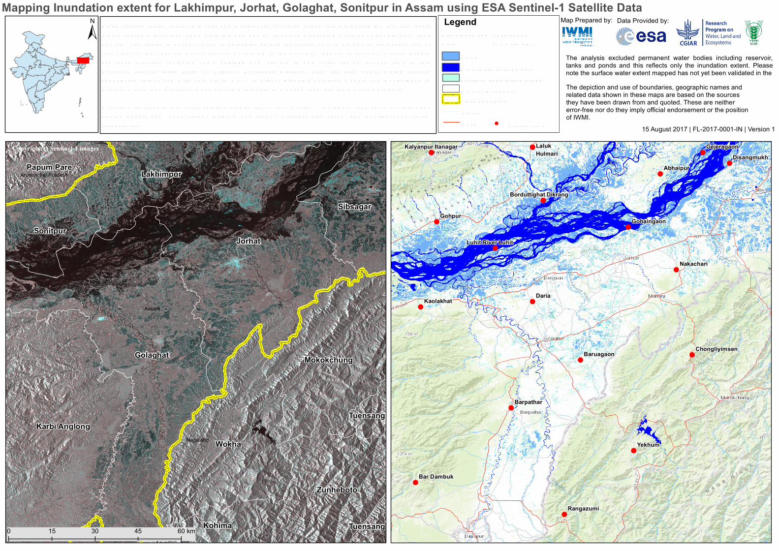
15 August 2017 | FL-2017-0001-IN | Version 1
Map Prepared by: Data Provided by:
The analysis excluded permanent water bodies including reservoir,tanks and ponds and this reflects only the inundation extent. Pleasenote the surface water extent mapped has not yet been validated in the
!
!
!
!
!!
!
!
!!!
!!
!
!
!
!
!
!
!
!
!
!
Daria
Laluk
Luhit
Gohpur
Yekhum
Dikrang
Hulmari
Abhaipur
Itanagar
Barpathar
Baruagaon
Kalyanpur
Kaolakhat
Nakachari
Rangazumi
Bar Dambuk
DisangmukhGejeragaon
Gohaingaon
Luhit River
Borduttighat
Chongliyimsen
LegendDisaster Im age :Sentine l-1Date :12 Aug. 2017
North-eastern Ind ia, southern Nepal and Banglad esh receive d heavy rainfall d uring the last fe w d ays,w hich cause d w id e spread flood claim ing 160 hum an lives and d isplacing m illions of people from theirhom es. The flood s im pose d econom ic hard ships am ong thousand s of farm ers d ue to the d estruction ofrice crops in the ongoing Kharif season. Accord ing to the official’s reports, at least 2.5 m illion peoplehad been affecte d , includ ing som e 200,000 now staying in 440 relie f cam ps. Second tim e in thism onsoon season, large areas of Assam 's Kaziranga National Park are also und er w ater, forcingend angere d rhinos and w ild anim als to m ove to higher ground .Kok rajhar, Dhubri and Bongaigaon inw estern Assam and Kaliabor, Dhem aji and Dibrugarh in Upper Assam are the w orst hit d istricts.
District w ise flood extent using satellite d ata (w ithout rive r m ask ) – Golaghat 1290 sq.k m , Jorhat 1352sq.k m , Lak him pur 1158 sq.k m , Nagaon 758 sq.k m , Sibsagar 147 sq.k m and Sonitpur1774 sq.k mrespective ly.
Mapping Inundation extent for Lakhimpur, Jorhat, Golaghat, Sonitpur in Assam using ESA Sentinel-1 Satellite Data
The depiction and use of boundaries, geographic names andrelated data shown in these maps are based on the sourcesthey have been drawn from and quoted. These are neithererror-free nor do they imply official endorsement or the positionof IWMI.
District Bound ary
Cities/Tow nR oad
FloodR iver/Perm anent w ater
!
Partially subm erge d crops
R ivers
±
0 30 6015 45 km
Copyright(c) Sentinel-1 images
State bound ary