PUQUIOS, QANATS Y MANANTIALES: GESTIÓN DEL AGUA … · Filtrante (Filtering Gallery), about which...
18
279 * Autor responsable v Author for correspondence. Recibido: diciembre, 2013. Aprobado: febrero, 2015. Publicado como ARTÍCULO en ASyD 12: 279-296. 2015. PUQUIOS, QANATS Y MANANTIALES: GESTIÓN DEL AGUA EN EL PERÚ ANTIGUO PUQUIOS, QANATS AND SPRINGS: WATER MANAGENT IN ANCIENT PERÚ Luis A. Ponce-Vega Universidad Nacional Federico Villareal. Lima, Perú. ([email protected]) RESUMEN En esta era marcada por el cambio climático, la desertifica- ción y el estrés hídrico se precisan como soluciones alternati- vas de bajo costo y alta efectividad para proporcionar agua a las comunidades rurales de bajos ingresos, a fin de satisfacer sus necesidades agrícolas y domésticas en armonía con su rea- lidad geográfica. La presente obra examina cómo las socieda- des agrarias de la cultura Nasca enfrentaron estos desafíos en uno de los desiertos más áridos del mundo, así como en los andes del sur peruano, cerca de la ciudad de Cusco, en áreas de intensas lluvias, difícil geografía y escasas tierras de culti- vo. Se desea conocer, específicamente, cómo se obtuvo, guar- dó y distribuyó el agua y qué importancia tuvo el uso del agua subterránea y la de manantiales; se desea saber, igualmente, el potencial del Perú en cuanto a aguas subterráneas. Se revisa la literatura especializada para responder estas interrogantes y conocer cómo se realizó la gestión del agua en estas socieda- des agrarias. Se plantea también que estas técnicas pueden ser potenciadas con tecnología de punta para mejorar la gestión de los recursos hídricos, como parte del esfuerzo internacio- nal para enfrentar el cambio climático. Palabras claves: agua subterránea, drenaje, muyus, Nasca, tierras áridas. INTRODUCCIÓN E l control del agua fue un tema vital en la Roma clásica, así como en otras civilizaciones anti- guas donde los acueductos, cisternas, reservo- rios, pilones y surtidores satisfacían las necesidades hídricas, agrícolas y urbanas, siendo parte esencial de su legado, que también incluye, por supuesto, al nymphaeum, fuente de excepcional belleza y modelo del uso ornamental del agua, que honró a las ninfas de los manantiales, protectoras del vital recurso (Wil- son, 2008). ABSTRACT In this era marked by climate change, desertification and water stress, low-cost and high-efficiency alternative solutions are required to provide low-income rural communities with water, in order to satisfy their agricultural and domestic needs in harmony with their geographic reality. is study examines how agrarian societies of the Nasca culture faced these challenges in one of the most arid deserts in the world, and in the Andes of southern Perú, near the city of Cusco, in areas with intense rains, difficult geography and scarce cultivation lands. e objective is to understand, specifically, how water was obtained, stored and distributed, and what importance the use of underground and spring water had; likewise, the aim is to understand Perú’s potential in terms of underground waters. Specialized literature is reviewed to respond these questions and to explore how water management was carried out in these agrarian societies. It is also suggested that these techniques can be strengthened with cutting edge technology to improve the management of water resources, as part of the international effort to face climate change. Key words: underground water, drainage, Nasca, arid lands. INTRODUCTION W ater control was a vital issue in classical Rome, as well as in other ancient civilizations where aqueducts, cisterns, reservoirs, fountains and pumps satisfied the water needs, agricultural and urban, being an essential part of their legacy, which also includes, naturally, the nymphaeum, source of exceptional beauty and model of the ornamental use of water, honoring springs’ nymphs, protectors of the vital resource (Wilson, 2008). Water was also a priority in the Middle East, cradle of the first civilizations. Not only did they build the first canals, pipes and siphons, but also the qanat, a structure composed of tunnels and wells that
Transcript of PUQUIOS, QANATS Y MANANTIALES: GESTIÓN DEL AGUA … · Filtrante (Filtering Gallery), about which...
279
* Autor responsable v Author for correspondence.Recibido: diciembre, 2013. Aprobado: febrero, 2015.Publicado como ARTÍCULO en ASyD 12: 279-296. 2015.
PUQUIOS, QANATS Y MANANTIALES: GESTIÓN DEL AGUA EN EL PERÚ ANTIGUO
PUQUIOS, QANATS AND SPRINGS: WATER MANAGENT IN ANCIENT PERÚ
Luis A. Ponce-Vega
Universidad Nacional Federico Villareal. Lima, Perú. ([email protected])
Resumen
En esta era marcada por el cambio climático, la desertifica-ción y el estrés hídrico se precisan como soluciones alternati-vas de bajo costo y alta efectividad para proporcionar agua a las comunidades rurales de bajos ingresos, a fin de satisfacer sus necesidades agrícolas y domésticas en armonía con su rea-lidad geográfica. La presente obra examina cómo las socieda-des agrarias de la cultura Nasca enfrentaron estos desafíos en uno de los desiertos más áridos del mundo, así como en los andes del sur peruano, cerca de la ciudad de Cusco, en áreas de intensas lluvias, difícil geografía y escasas tierras de culti-vo. Se desea conocer, específicamente, cómo se obtuvo, guar-dó y distribuyó el agua y qué importancia tuvo el uso del agua subterránea y la de manantiales; se desea saber, igualmente, el potencial del Perú en cuanto a aguas subterráneas. Se revisa la literatura especializada para responder estas interrogantes y conocer cómo se realizó la gestión del agua en estas socieda-des agrarias. Se plantea también que estas técnicas pueden ser potenciadas con tecnología de punta para mejorar la gestión de los recursos hídricos, como parte del esfuerzo internacio-nal para enfrentar el cambio climático.
Palabras claves: agua subterránea, drenaje, muyus, Nasca, tierras áridas.
IntRoduccIón
El control del agua fue un tema vital en la Roma clásica, así como en otras civilizaciones anti-guas donde los acueductos, cisternas, reservo-
rios, pilones y surtidores satisfacían las necesidades hídricas, agrícolas y urbanas, siendo parte esencial de su legado, que también incluye, por supuesto, al nymphaeum, fuente de excepcional belleza y modelo del uso ornamental del agua, que honró a las ninfas de los manantiales, protectoras del vital recurso (Wil-son, 2008).
AbstRAct
In this era marked by climate change, desertification and water stress, low-cost and high-efficiency alternative solutions are required to provide low-income rural communities with water, in order to satisfy their agricultural and domestic needs in harmony with their geographic reality. This study examines how agrarian societies of the Nasca culture faced these challenges in one of the most arid deserts in the world, and in the Andes of southern Perú, near the city of Cusco, in areas with intense rains, difficult geography and scarce cultivation lands. The objective is to understand, specifically, how water was obtained, stored and distributed, and what importance the use of underground and spring water had; likewise, the aim is to understand Perú’s potential in terms of underground waters. Specialized literature is reviewed to respond these questions and to explore how water management was carried out in these agrarian societies. It is also suggested that these techniques can be strengthened with cutting edge technology to improve the management of water resources, as part of the international effort to face climate change.
Key words: underground water, drainage, Nasca, arid lands.
IntRoductIon
Water control was a vital issue in classical Rome, as well as in other ancient civilizations where aqueducts, cisterns,
reservoirs, fountains and pumps satisfied the water needs, agricultural and urban, being an essential part of their legacy, which also includes, naturally, the nymphaeum, source of exceptional beauty and model of the ornamental use of water, honoring springs’ nymphs, protectors of the vital resource (Wilson, 2008). Water was also a priority in the Middle East, cradle of the first civilizations. Not only did they build the first canals, pipes and siphons, but also the qanat, a structure composed of tunnels and wells that

AGRICULTURA, SOCIEDAD Y DESARROLLO, JULIO - SEPTIEMBRE 2015
VOLUMEN 12, NÚMERO 3280
En el Cercano Oriente, cuna de las primeras civi-lizaciones, también se dio prioridad al agua. No solo construyeron los primeros canales, tuberías y sifones, sino también al qanat, estructura compuesta de tú-neles y pozos que proveyó de agua a las tierras más áridas del mundo y que, en opinión de Wilson, re-presenta uno de los desarrollos más importantes en la historia de la ingeniería hidráulica (Wilson, 2008). El qanat se extendió al Lejano Oriente, a Europa y al Nuevo Mundo, recibiendo en México el nom-bre de Galería Filtrante, del cual Palerm Viqueira (2004) realizó un detallado estudio sobre su tipología y distribución, quedando pendiente el tema del pu-quio peruano. Sobre este particular, Barnes y Fleming (1991) plantearon la hipótesis de un probable origen español del puquio de Nasca; en cambio, Schreiber y Lancho (2003, 2006) los vieron como un sub-pro-ducto de la cultura Nasca. Aunque el debate sobre el origen de los puquios aún no concluye1, los aportes planteados en lo que va del presente siglo nos permi-ten una mejor comprensión de esta técnica que irri-ga tierras de aridez extrema en Nasca. Por extensión, también despertó el interés por la gestión del agua en los Andes del sur del Perú, en tanto que las técnicas usadas por los antiguos peruanos en los desiertos cos-teros, así como en las cuencas y altiplanicies andinas, materializan su conocimiento sobre la geografía local y los recursos disponibles y su correlación con una visión del mundo que valora el agua subterránea. Para acceder a las técnicas hidráulicas del anti-guo Perú, centro originario de cultura, se revisan los casos de Nasca, Machu Picchu y Moray, ejemplos notables del conocimiento andino sobre el manejo del agua. Gracias a los estudios de científicos e inge-nieros, con la ayuda de las nuevas técnicas no inva-sivas, se ha podido tener una mejor comprensión de las técnicas hidráulicas de estas culturas que pueden ayudarnos en el esfuerzo internacional para enfren-tar el cambio climático. En tal sentido se examina cómo se enfrentó la gestión del agua tanto en la cul-tura Nasca, ubicada en uno de los desiertos más ári-dos del mundo, como en los andes del sur del Perú, cerca de la ciudad de Cusco, en áreas de intensas lluvias, difícil geografía y escasas tierras de cultivo. Se examina, con especial cuidado, cómo se obtuvo, guardó y distribuyó el agua, y qué importancia tuvo el agua subterránea o de manantial. Igualmente, se deseaba conocer el potencial actual del Perú sobre estos recursos.
supplied water to the most arid lands in the world and which, in Wilson’s opinion, represented one of the most important developments in the history of hydraulic engineering (Wilson, 2008). The qanat spread to the Far East, Europe and the New World, receiving in México the name of Galería Filtrante (Filtering Gallery), about which Palerm Viqueira (2004) carried out a detailed study on its typology and distribution; however, the topic of the Peruvian puquio remained pending. About this particular, Barnes and Fleming (1991) set out the hypothesis of a probable Spanish origin for Nasca’s puquio; in contrast, Schreiber and Lancho (2003, 2006) regarded them as a sub-product of the Nasca culture. Although the debate about the origin of puquios is not settled yet1, the contributions suggested so far in this century allow us a better comprehension of this technique for irrigating extreme arid lands in Nasca. By extension, it also stimulated interest about water management in the Andes of southern Perú, since the techniques used by the ancient Peruvian peoples in the coastal deserts, as well as in the Andean basins and highlands, materialize their knowledge about local geography and the resources available, and their correlation with a vision of the world that values underground water. In order to gain access to the hydraulic techniques of ancient Perú, native center of culture, the cases of Nasca, Machu Picchu and Moray are reviewed, notable examples of Andean knowledge about water management. Thanks to the studies by scientists and engineers, with the help of new non-invasive techniques, a better understanding of the hydraulic systems from these cultures has been attained, which can help us in the international effort to face climate change. In this sense, the way in which water management was approached is examined, both in the Nasca culture, located in one of the most arid deserts of the world, and in the Andes of southern Perú, near the city of Cusco, in areas with intense rains, difficult geography and scarce cultivation lands. The way in which water was obtained, stored and distributed, is examined with special care, as well as the importance of underground water or spring water. Also, the aim was to understand Perú’s current potential with these resources. From the examination performed, it can be concluded that springs or underground water fed the puquios from the Nasca culture, as well as the
281PONCE-VEGA
PUQUIOS, QANATS Y MANANTIALES: GESTIÓN DEL AGUA EN EL PERÚ ANTIGUO
Del examen realizado se puede concluir que los manantiales o las aguas subterráneas alimentaron los puquios de la cultura Nasca, al igual que las obras hi-dráulicas de Machu Picchu y los muyus de Moray. Estos dos últimos centros, igualmente, muestran el estado del arte de las técnicas hidráulicas de los in-cas en una etapa previa a la influencia europea. Fi-nalmente, los escasos estudios realizados sobre aguas subterráneas en el Perú sugieren la existencia de un importante potencial, el mismo que requiere de fu-turos estudios específicos que permitan potenciar los sistemas tradicionales, en el contexto de una gestión integrada de cuencas.
QAnAt: estAdo del ARte
El origen del qanat es un tema abierto. General-mente se asume que se originó en la antigua Persia (Irán) porque allí existe hoy en día un gran número de qanats, túneles, galerías, pozos y canales de larga distancia para conducir el agua de ríos permanentes, erigidos hace treinta siglos. En la actualidad se puede observar que los túneles más largos fueron construi-dos entre pares de pozos verticales que estaban a in-tervalos suficientemente cortos para facilitar su man-tenimiento y ventilación, permitiendo su control desde la superficie. En cambio, el qanat es una galería que colecta agua subterránea por medio de un túnel que la conduce por gravedad, para emerger donde el nivel de la superficie es menor que el del acuífero. La diferencia estriba en que los asirios empleaban el agua de un río o un manantial, mientras que el qanat utilizaba agua subterránea. Según Wilson (2008), la evidencia disponible sugiere dos posibilidades. En primer lugar, que los asirios desarrollaron la técnica de los túneles de ga-lerías horizontales y pozos verticales, y que ésta fue empleada posteriormente para extraer el agua subte-rránea que se halla a una cierta profundidad (pero a un nivel más elevado que la superficie en otro lugar), pudiendo ser conducida a la superficie por dichos tú-neles; segundo, que el qanat fue inventado, tomando en cuenta la técnica de galerías y pozos y el manejo de la fuente subterránea. Sobre el tema, Wilson indica que no es posible tener certeza hasta no disponer de medidas confiables sobre la antigüedad de los prime-ros qanats. Sugiere, sin embargo, que la primera de las dos posibilidades parece ser la más fácil de aceptar porque, si se confirma que los asirios inventaron la
hydraulic works in Machu Picchu or the muyus in Moray. These last two centers, likewise, show the state-of-the-art of the Inca’s hydraulic techniques during a stage prior to European influence. Finally, the few studies performed about underground water in Perú suggest the existence of an important potential, requiring specific future studies that allow promoting traditional systems within the context of integral basin management.
QAnAt: stAte-of- the-ARt
The origin of the qanat is an open topic. Generally, it is assumed that it originated in ancient Persia (Iran) because there is a large number of qanats there today, as well as tunnels, galleries, wells, and long-distance canals to lead water from permanent rivers, erected thirty centuries ago. Nowadays, it can be seen that the longest tunnels were built between vertical well pairs that were located at sufficiently short distances to facilitate their maintenance and ventilation, allowing their control from the surface. Instead, the qanat is a gallery that collects underground water through a tunnel that leads it by gravity, in order to emerge where the level of the surface is lower than that of the aquifer. The difference is that the Assyrians used water from a river or a spring, while the qanat used underground water. According to Wilson (2008), the evidence available suggests two possibilities. In the first place, that the Assyrians developed the technique of tunnels with horizontal galleries and vertical wells, and that it was later used to extract the underground water that is found at a certain depth (but at a higher level than the surface in another place), allowing it to be conducted to the surface through those tunnels; second, that the qanat was invented, taking into account the technique of galleries and wells, and the management of the underground source. Regarding this idea, Wilson indicates that it is not possible to be certain until there are reliable measurements about the antiquity of the first qanats. He suggests, however, that the first of the two possibilities seems to be the easiest to accept because, if it is confirmed that the Assyrians invented the technique of galleries and wells and that it was later applied to the qanat, the finding would be in agreement, indeed, with the different trajectories for distribution of these techniques in the Classical world, since it is documented that the

AGRICULTURA, SOCIEDAD Y DESARROLLO, JULIO - SEPTIEMBRE 2015
VOLUMEN 12, NÚMERO 3282
técnica de galerías y pozos y que ésta fue luego apli-cada al qanat, el hallazgo estaría en concordancia, ciertamente, con las diferentes trayectorias de difu-sión de estas técnicas en el mundo clásico, ya que está documentado que el túnel de galerías y pozos se propagó al mundo griego y etrusco, pero no ocurrió lo mismo con el qanat (Wilson, 2008: 293). Por lo tanto, mientras que este tema no se resuelva, resulta sensato discriminar entre las técnicas antes mencio-nadas.
huncólpI: oRIgen de los puQuIos de nAscA
Cuando María Rostworowski (2006) acude a la sección vocabulario quechua castellano de los pri-meros diccionarios publicados en 1560 y 1608 en el Perú, encuentra que “pukyu” significa “fuente o manantial” (según González Holguín)2 y que “pucyo” significa “manantial de agua, fuente” (según Santo Tomás)3. Cuando revisa la sección castellano-que-chua de los mismos diccionarios, buscando vocablos quechuas relativos a “fuente”, encuentra las siguien-tes correspondencias: “Fuente manantial que sale de baxo= pucyo” y “Fuente así que sale de alto = pac-cha” (según González Holguín) y “Fuente de caños que salen = huncólpi” (según Santo Tomás). De lo expuesto, Rostworoski concluye lo siguiente: “De lo anterior, podemos deducir que la voz puquio signi-ficaría una fuente o un manantial y que la palabra para galería filtrante estaría más de acuerdo con la voz huncólpi.” (Rostworowski, 2006). Entonces, cuando se usa el término “pukyu” o “puquio” se hace alusión a los ojos de agua que se ha-llan en la cordillera de los Andes. En cambio, cuando se trata de los puquios de la cultura Nasca (huncólpi, si se desea mayor precisión), los especialistas se refie-ren a los canales, tanto abiertos como subterráneos, que extraen aguas subálveas del subsuelo, construidos por las poblaciones originarias, antes del arribo de los españoles (Schreiber y Lancho, 2006). Los puquios de la cultura Nasca se ubican al sur de la costa central del Perú, entre el Océano Pacífico y las primeras estribaciones de los Andes; en uno de los desiertos más secos y áridos del mundo (Shima-da, 1999). Aunque solo tiene una longitud de 153 kilómetros, el río Grande es el más importante de la provincia de Nasca, pero también uno de los más secos de la costa peruana. Baste recordar que cuando
tunnel with galleries and wells spread to the Greek and Etruscan world, but the same did not happen with the qanat (Wilson, 2008: 293). Therefore, while this issue is not resolved, it is wise to discriminate between the techniques mentioned before.
huncólpI: oRIgIn of the nAscA puquios
When María Rostworowski (2006) resorts to the Quechua-Spanish vocabulary section of the first dictionaries published in 1560 and 1608 in Perú, she finds that “pukyu” means “source or spring” (according to González Holguín)2 and that “pucyo” means “water spring, source” (according to Santo Tomás)3. When she reviews the Spanish-Quechua section of the same dictionaries, looking for Quechua words related to “source”, she finds the following correspondences: “Spring source that comes from down low= pucyo” and “Source like this that come from high up= paccha” (according to González Holguín and “Source from tubes that stick out= huncólpi” (according to Santo Tomás). From what was exposed, Rostworowski concludes the following: “From this, we can deduce that the word puquio means a source or a spring and that the word for filtering gallery would be more in agreement with the word huncólpi” (Rostworowski, 2006). Therefore, when the term “pukyo” or “puquio” is used, there is a reference to the water fountains that are found in the Andean mountain chain. In contrast, when it is the puquios of the Nasca culture (huncólpi, for greater precision), the specialists refer to the canals, both open and underground, that extract underground water from the undersoil, built by original populations before the arrival of the Spanish (Schreiber and Lancho, 2006). The puquios of the Nasca culture are located south of the central coast of Perú, between the Pacific Ocean and the first foothills of the Andes, in one of the most dry and arid deserts of the world (Shimada, 1999). Although it only has a length of 153 kilometers, the Grande River is the most important of the province of Nasca, but it is also one of the driest in the Peruvian coast. It’s enough to remember that when Antonio Raimondi visited the area in 1863 (during the great drought of 1860-64), he gave testimony that water only flowed during 40 days. The most notable aspect of the Grande River basin is its tributary rivers to the south4, where there
283PONCE-VEGA
PUQUIOS, QANATS Y MANANTIALES: GESTIÓN DEL AGUA EN EL PERÚ ANTIGUO
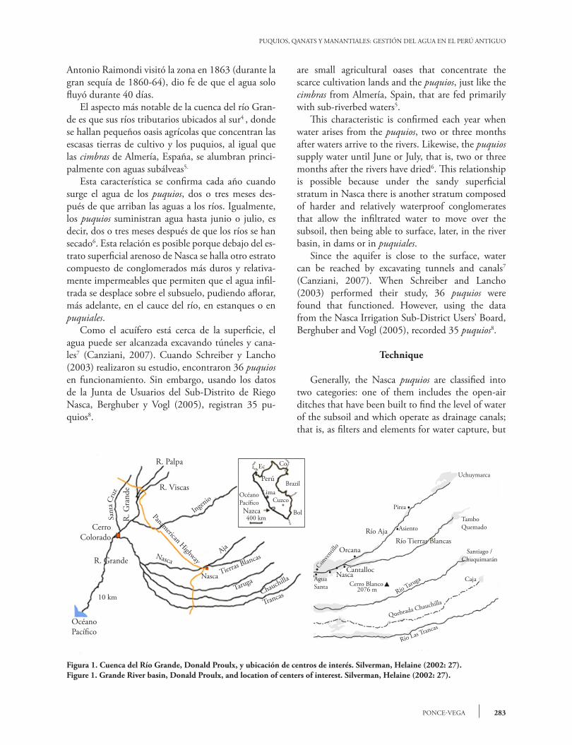
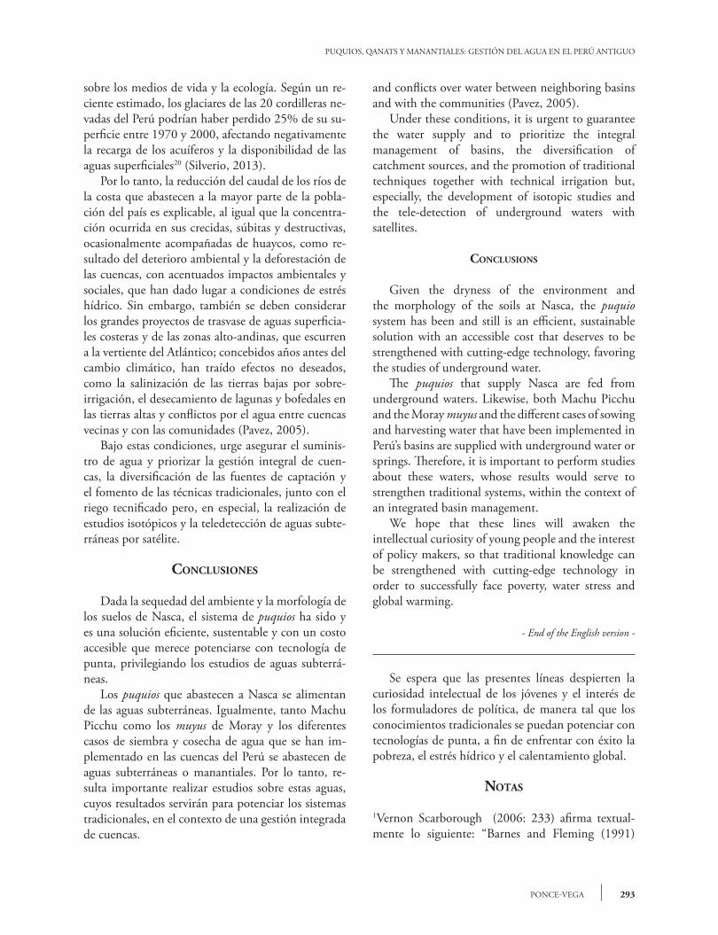
Antonio Raimondi visitó la zona en 1863 (durante la gran sequía de 1860-64), dio fe de que el agua solo fluyó durante 40 días. El aspecto más notable de la cuenca del río Gran-de es que sus ríos tributarios ubicados al sur4 , donde se hallan pequeños oasis agrícolas que concentran las escasas tierras de cultivo y los puquios, al igual que las cimbras de Almería, España, se alumbran princi-palmente con aguas subálveas5.
Esta característica se confirma cada año cuando surge el agua de los puquios, dos o tres meses des-pués de que arriban las aguas a los ríos. Igualmente, los puquios suministran agua hasta junio o julio, es decir, dos o tres meses después de que los ríos se han secado6. Esta relación es posible porque debajo del es-trato superficial arenoso de Nasca se halla otro estrato compuesto de conglomerados más duros y relativa-mente impermeables que permiten que el agua infil-trada se desplace sobre el subsuelo, pudiendo aflorar, más adelante, en el cauce del río, en estanques o en puquiales. Como el acuífero está cerca de la superficie, el agua puede ser alcanzada excavando túneles y cana-les7 (Canziani, 2007). Cuando Schreiber y Lancho (2003) realizaron su estudio, encontraron 36 puquios en funcionamiento. Sin embargo, usando los datos de la Junta de Usuarios del Sub-Distrito de Riego Nasca, Berghuber y Vogl (2005), registran 35 pu-quios8.
Figura 1. Cuenca del Río Grande, Donald Proulx, y ubicación de centros de interés. Silverman, Helaine (2002: 27).Figure 1. Grande River basin, Donald Proulx, and location of centers of interest. Silverman, Helaine (2002: 27).
are small agricultural oases that concentrate the scarce cultivation lands and the puquios, just like the cimbras from Almería, Spain, that are fed primarily with sub-riverbed waters5. This characteristic is confirmed each year when water arises from the puquios, two or three months after waters arrive to the rivers. Likewise, the puquios supply water until June or July, that is, two or three months after the rivers have dried6. This relationship is possible because under the sandy superficial stratum in Nasca there is another stratum composed of harder and relatively waterproof conglomerates that allow the infiltrated water to move over the subsoil, then being able to surface, later, in the river basin, in dams or in puquiales. Since the aquifer is close to the surface, water can be reached by excavating tunnels and canals7 (Canziani, 2007). When Schreiber and Lancho (2003) performed their study, 36 puquios were found that functioned. However, using the data from the Nasca Irrigation Sub-District Users’ Board, Berghuber and Vogl (2005), recorded 35 puquios8.
Technique
Generally, the Nasca puquios are classified into two categories: one of them includes the open-air ditches that have been built to find the level of water of the subsoil and which operate as drainage canals; that is, as filters and elements for water capture, but
R. Palpa
R. Viscas
R. G
rand
e
CerroColorado
R. Grande
Océano Pací�co
OcéanoPací�co
Perú
Ec Co
BrazilLima
Cuzco
Bol400 km
NazcaIngenio
Panamerican Highway
AjaNasca
Tierras Blancas
Nasca
TarugaChauchilla
Trancas
Sant
aCru
z
10 km
Conven
tilloOrcana
CantallocNascaAgua
Santa Cerro Blanco2076 m
Río AjaRío Tierras Blancas
Pirea
AsientoTambo Quemado
Santiago /Chuquimarán
Caja
Río Taruga
Quebrada Chauchilla
Río Las Trancas
Uchuymarca
AGRICULTURA, SOCIEDAD Y DESARROLLO, JULIO - SEPTIEMBRE 2015
VOLUMEN 12, NÚMERO 3284
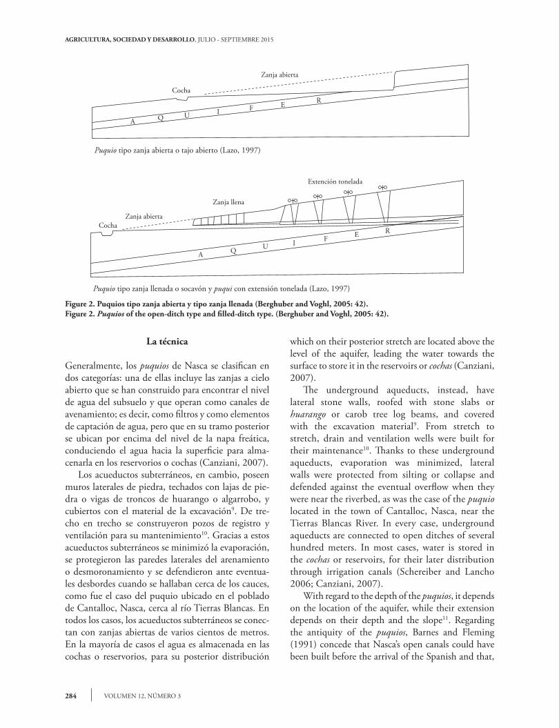
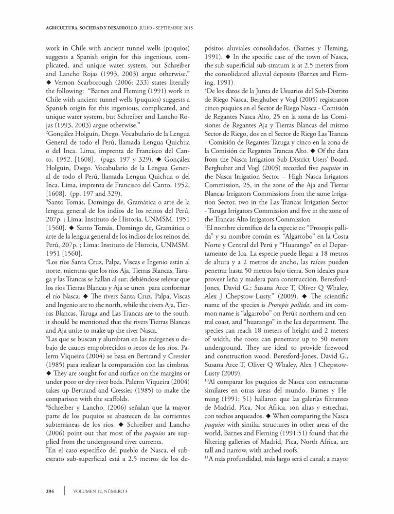
La técnica
Generalmente, los puquios de Nasca se clasifican en dos categorías: una de ellas incluye las zanjas a cielo abierto que se han construido para encontrar el nivel de agua del subsuelo y que operan como canales de avenamiento; es decir, como filtros y como elementos de captación de agua, pero que en su tramo posterior se ubican por encima del nivel de la napa freática, conduciendo el agua hacia la superficie para alma-cenarla en los reservorios o cochas (Canziani, 2007). Los acueductos subterráneos, en cambio, poseen muros laterales de piedra, techados con lajas de pie-dra o vigas de troncos de huarango o algarrobo, y cubiertos con el material de la excavación9. De tre-cho en trecho se construyeron pozos de registro y ventilación para su mantenimiento10. Gracias a estos acueductos subterráneos se minimizó la evaporación, se protegieron las paredes laterales del arenamiento o desmoronamiento y se defendieron ante eventua-les desbordes cuando se hallaban cerca de los cauces, como fue el caso del puquio ubicado en el poblado de Cantalloc, Nasca, cerca al río Tierras Blancas. En todos los casos, los acueductos subterráneos se conec-tan con zanjas abiertas de varios cientos de metros. En la mayoría de casos el agua es almacenada en las cochas o reservorios, para su posterior distribución
which on their posterior stretch are located above the level of the aquifer, leading the water towards the surface to store it in the reservoirs or cochas (Canziani, 2007). The underground aqueducts, instead, have lateral stone walls, roofed with stone slabs or huarango or carob tree log beams, and covered with the excavation material9. From stretch to stretch, drain and ventilation wells were built for their maintenance10. Thanks to these underground aqueducts, evaporation was minimized, lateral walls were protected from silting or collapse and defended against the eventual overflow when they were near the riverbed, as was the case of the puquio located in the town of Cantalloc, Nasca, near the Tierras Blancas River. In every case, underground aqueducts are connected to open ditches of several hundred meters. In most cases, water is stored in the cochas or reservoirs, for their later distribution through irrigation canals (Schereiber and Lancho 2006; Canziani, 2007). With regard to the depth of the puquios, it depends on the location of the aquifer, while their extension depends on their depth and the slope11. Regarding the antiquity of the puquios, Barnes and Fleming (1991) concede that Nasca’s open canals could have been built before the arrival of the Spanish and that,
Figure 2. Puquios tipo zanja abierta y tipo zanja llenada (Berghuber and Voghl, 2005: 42).Figure 2. Puquios of the open-ditch type and filled-ditch type. (Berghuber and Voghl, 2005: 42).
CochaZanja abierta
Zanja llena
Extención tonelada
A Q U I F E R
Cocha
Zanja abierta
Puquio tipo zanja abierta o tajo abierto (Lazo, 1997)
Puquio tipo zanja llenada o socavón y puqui con extensión tonelada (Lazo, 1997)
A Q U I F E R
285PONCE-VEGA
PUQUIOS, QANATS Y MANANTIALES: GESTIÓN DEL AGUA EN EL PERÚ ANTIGUO
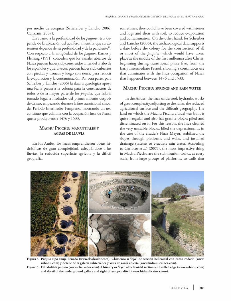
por medio de acequias (Schereiber y Lancho 2006; Canziani, 2007). En cuanto a la profundidad de los puquios, ésta de-pende de la ubicación del acuífero, mientras que su ex-tensión depende de su profundidad y de la pendiente11. Con respecto a la antigüedad de los puquios, Barnes y Fleming (1991) conceden que los canales abiertos de Nasca pueden haber sido construidos antes del arribo de los españoles y que, a veces, pueden haber sido cubiertos con piedras y troncos y luego con tierra, para reducir la evaporación y la contaminación. Por otra parte, para Schreiber y Lancho (2006) la data arqueológica apoya una fecha previa a la colonia para la construcción de todos o de la mayor parte de los puquios, que habría tomado lugar a mediados del primer milenio después de Cristo, empezando durante la fase transicional cinco, del Período Intermedio Temprano, mostrando un uso continuo que culmina con la ocupación Inca de Nasca que se produjo entre 1476 y 1533.
mAchu pIcchu: mAnAntIAles y AguAs de lluvIA
En los Andes, los incas emprendieron obras hi-dráulicas de gran complejidad, adecuándose a las lluvias, la reducida superficie agrícola y la difícil geografía.
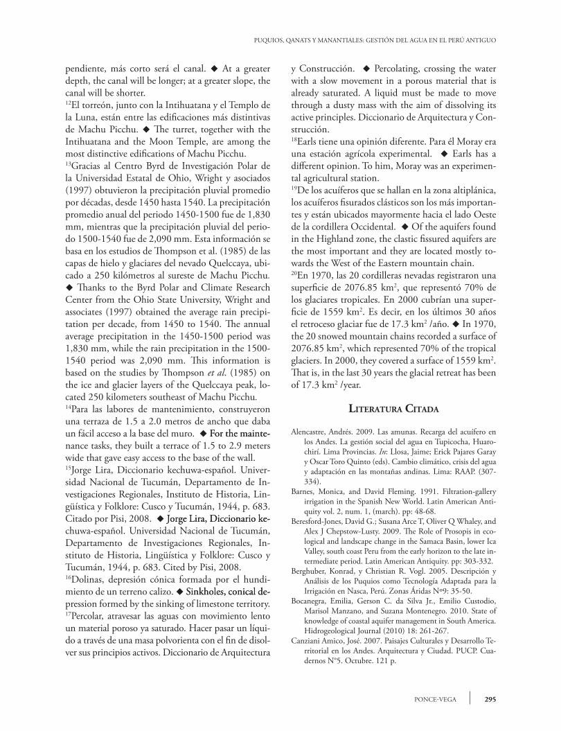
Figura 3. Puquio tipo zanja llenada (www.elsalvador.com). Chimenea u “ojo” de sección helicoidal con canto rodado (www.urbonu.com) y detalle de la galeria subterránea y vista de zanja abierta (www.hidraulicainca.com).
Figure 3. Filled-ditch puquio (www.elsalvador.com). Chimney or “eye” of helicoidal section with rolled edge (www.urbonu.com) and detail of the underground gallery and sight of an open ditch (www.hidraulicainca.com).
sometimes, they could have been covered with stones and logs and then with soil, to reduce evaporation and contamination. On the other hand, for Schreiber and Lancho (2006), the archaeological data supports a date before the colony for the construction of all or most of the puquios, which would have taken place at the middle of the first millennia after Christ, beginning during transitional phase five, from the Early Intermediate Period, showing a continuous use that culminates with the Inca occupation of Nasca that happened between 1476 and 1533.
mAchu pIcchu: spRIngs And RAIn wAteR
In the Andes, the Inca undertook hydraulic works of great complexity, adjusting to the rains, the reduced agricultural surface and the difficult geography. The land on which the Machu Picchu citadel was built is quite irregular and also has granite blocks piled and disseminated on it. For this reason, the Inca cleaned the very unstable blocks, filled the depressions, as in the case of the citadel’s Plaza Mayor, stabilized the slopes through platforms and walls, and installed drainage systems to evacuate rain water. According to Carlotto et al. (2009), the most impressive thing in Machu Picchu are the stabilization works, at every scale, from large groups of platforms, to walls that
AGRICULTURA, SOCIEDAD Y DESARROLLO, JULIO - SEPTIEMBRE 2015
VOLUMEN 12, NÚMERO 3286
El terreno sobre el que se construyó la ciudadela de Machu Picchu es muy irregular y cuenta, además, con bloques de granito apilados y diseminados sobre él. Por tal razón, los incas limpiaron los bloques muy inesta-bles, rellenaron las depresiones, como en el caso de la Plaza Mayor de la ciudadela, estabilizaron las laderas mediante andenerías y muros, e instalaron sistemas de drenajes para evacuar las aguas de lluvia. Según Carlotto et al. (2009), lo que más impresiona en Machu Picchu son las obras de estabilización, a todas las escalas, desde grandes conjuntos de andenes, hasta muros que sostie-nen bloques graníticos grandes y algunos muy impor-tantes, como el Torreón12. (Carlotto et al., 2009).
Precipitación pluvial y sistemas de drenaje
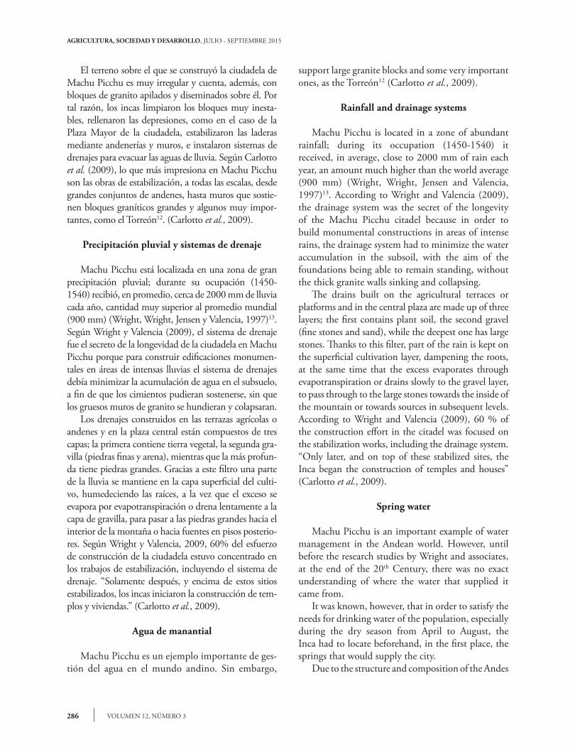
Machu Picchu está localizada en una zona de gran precipitación pluvial; durante su ocupación (1450-1540) recibió, en promedio, cerca de 2000 mm de lluvia cada año, cantidad muy superior al promedio mundial (900 mm) (Wright, Wright, Jensen y Valencia, 1997)13. Según Wright y Valencia (2009), el sistema de drenaje fue el secreto de la longevidad de la ciudadela en Machu Picchu porque para construir edificaciones monumen-tales en áreas de intensas lluvias el sistema de drenajes debía minimizar la acumulación de agua en el subsuelo, a fin de que los cimientos pudieran sostenerse, sin que los gruesos muros de granito se hundieran y colapsaran. Los drenajes construidos en las terrazas agrícolas o andenes y en la plaza central están compuestos de tres capas; la primera contiene tierra vegetal, la segunda gra-villa (piedras finas y arena), mientras que la más profun-da tiene piedras grandes. Gracias a este filtro una parte de la lluvia se mantiene en la capa superficial del culti-vo, humedeciendo las raíces, a la vez que el exceso se evapora por evapotranspiración o drena lentamente a la capa de gravilla, para pasar a las piedras grandes hacia el interior de la montaña o hacia fuentes en pisos posterio-res. Según Wright y Valencia, 2009, 60% del esfuerzo de construcción de la ciudadela estuvo concentrado en los trabajos de estabilización, incluyendo el sistema de drenaje. “Solamente después, y encima de estos sitios estabilizados, los incas iniciaron la construcción de tem-plos y viviendas.” (Carlotto et al., 2009).
Agua de manantial
Machu Picchu es un ejemplo importante de ges-tión del agua en el mundo andino. Sin embargo,
support large granite blocks and some very important ones, as the Torreón12 (Carlotto et al., 2009).
Rainfall and drainage systems
Machu Picchu is located in a zone of abundant rainfall; during its occupation (1450-1540) it received, in average, close to 2000 mm of rain each year, an amount much higher than the world average (900 mm) (Wright, Wright, Jensen and Valencia, 1997)13. According to Wright and Valencia (2009), the drainage system was the secret of the longevity of the Machu Picchu citadel because in order to build monumental constructions in areas of intense rains, the drainage system had to minimize the water accumulation in the subsoil, with the aim of the foundations being able to remain standing, without the thick granite walls sinking and collapsing. The drains built on the agricultural terraces or platforms and in the central plaza are made up of three layers; the first contains plant soil, the second gravel (fine stones and sand), while the deepest one has large stones. Thanks to this filter, part of the rain is kept on the superficial cultivation layer, dampening the roots, at the same time that the excess evaporates through evapotranspiration or drains slowly to the gravel layer, to pass through to the large stones towards the inside of the mountain or towards sources in subsequent levels. According to Wright and Valencia (2009), 60 % of the construction effort in the citadel was focused on the stabilization works, including the drainage system. “Only later, and on top of these stabilized sites, the Inca began the construction of temples and houses” (Carlotto et al., 2009).
Spring water
Machu Picchu is an important example of water management in the Andean world. However, until before the research studies by Wright and associates, at the end of the 20th Century, there was no exact understanding of where the water that supplied it came from. It was known, however, that in order to satisfy the needs for drinking water of the population, especially during the dry season from April to August, the Inca had to locate beforehand, in the first place, the springs that would supply the city. Due to the structure and composition of the Andes
287PONCE-VEGA
PUQUIOS, QANATS Y MANANTIALES: GESTIÓN DEL AGUA EN EL PERÚ ANTIGUO
hasta antes de los trabajos de investigación de Wright y asociados, de fines del siglo veinte, no se sabía con exactitud de dónde provenía el agua que la abastecía. Se sabía, sin embargo, que para satisfacer las ne-cesidades de agua potable de la población, en especial durante la temporada seca, que va de abril a agosto; los incas debían haber localizado, en primer lugar, los manantiales que abastecerían a la urbe. Debido a la estructura y composición de los an-des, (rocas metamórficas, intrusivas y sedimentarias), el agua se infiltra entre las diaclasas y fracturas en las alturas, acumulándose en pequeños espacios, entre las rocas, aflorando en altitudes inferiores. Wright y Valencia (2009) descubren que el manantial princi-pal que abastece a Machu Picchu está ubicado en una loma al norte de la ciudadela, a una altura de 2458 msnm, y que se alimenta de las lluvias de una cuenca hidrográfica tributaria de unas 16.3 hectáreas. Según los estimados de Wright, Kelly y Valencia (1997), la producción del manantial principal puede fluctuar entre 25 y 125 litros por minuto, de acuerdo con si uno se halla en la estación seca (abril-agosto) o en la de mayor descarga pluvial (enero-marzo), una cantidad adecuada para satisfacer hasta 1000 habi-tantes. Asimismo, el análisis hidrológico realizado en 1997 por el equipo de Kenneth Wright sugiere que la producción de la fuente primaria está relacionada con la cantidad de lluvia precipitada, con un retar-do de poco más de cuatro meses, pudiendo abastecer la ciudadela en la temporada seca, de abril a agosto (Wright y Valencia, 2009). Para utilizar el manantial principal, los incas cons-truyeron un muro macizo de piedras permeables, de 14.6 m de largo y 1.4 metros de altura, por el cual se filtra el agua a una fosa rectangular de piedra, que se conecta al canal de 749 m, con una pendiente de 3% que abastece las 16 fuentes de la zona urbana de Machu Picchu14. También se usó el agua de un ma-nantial secundario, que entra al canal de recolección 80 metros al oeste del manantial principal (Wright, Kelly y Valencia, 1997). Para minimizar la erosión de los edificios de la zona urbana, estos contaban con techos de paja y 129 canales de drenaje superficial que desembocan, mayormente, en el canal principal de desagüe, que separa la zona urbana de la agrícola. De otro lado, las necesidades de agua de las terrazas de cultivo (ande-nes) fueron satisfechas por las lluvias, mientras que las aguas del río, 500 m más abajo, eran una opción
(metamorphic, intrusive and sedimentary rocks), water filters between the joints and fissures in the heights, accumulates between small spaces between the rocks and surfaces in lower altitudes. Wright and Valencia (2009) discovered that the main spring that supplies Machu Picchu is located on a hill north of the citadel, at an altitude of 2458 masl, and that it is fed by the rains in a tributary hydrographic basin of around 16.3 hectares. According to the estimates by Wright, Kelly and Valencia (1997), the main spring’s production can fluctuate at between 25 and 125 liters per minute, depending on whether it is the dry season (April-August) or the one with greatest rainfall (January-March), an amount adequate to satisfy up to 1000 residents. Likewise, the hydrological analysis performed in 1997 by Kenneth Wright’s team suggests that the production of the primary source is related with the amount of rainfall, with a delay of slightly over four months, which could supply the citadel during the dry season, from April to August (Wright and Valencia, 2009). To use the main spring, the Inca built a strong wall of permeable stones, 14.6 m long and 1.4 m high, through which the water filters to a rectangular stone moat, which connects to the 749 m long canal, with a slope of 3 %, supplying the 16 fountains in the urban zone of Machu Picchu14. The water from a secondary spring was also used, which enters the recollection canal 80 m west of the principal spring (Wright, Kelly and Valencia, 1997). To minimize the erosion on the urban zone buildings, these had straw thatching and 129 superficial drainage canals that discharge, mostly, into the main drainage canal separating the urban from the agricultural zones. On the other hand, the water needs of the cultivation terraces (platforms) were satisfied by the rains, while water from the river, 500 m below, was an available option as a back-up system (Wright, Valencia and Lorah, 1999). In 1994, Wright was pleasantly surprised that after four centuries and a half the spring still continued to supply water to Machu Picchu, at the same time that the drainage system still functioned (Wright and Wright, 1996).
the muyus In moRAy
The muyus, found in the locality of Moray, Maras district, Cusco department, were accidentally

AGRICULTURA, SOCIEDAD Y DESARROLLO, JULIO - SEPTIEMBRE 2015
VOLUMEN 12, NÚMERO 3288
disponible, como un sistema de respaldo (Wright, Valencia y Lorah, 1999). En 1994, Wright se sorprendió gratamente de que después de cuatro siglos y medio el manantial aún continuaba abasteciendo de agua a Machu Pic-chu, al mismo tiempo que el sistema de drenaje aún funcionaba (Wright y Wright, 1996).
los muyus de moRAy
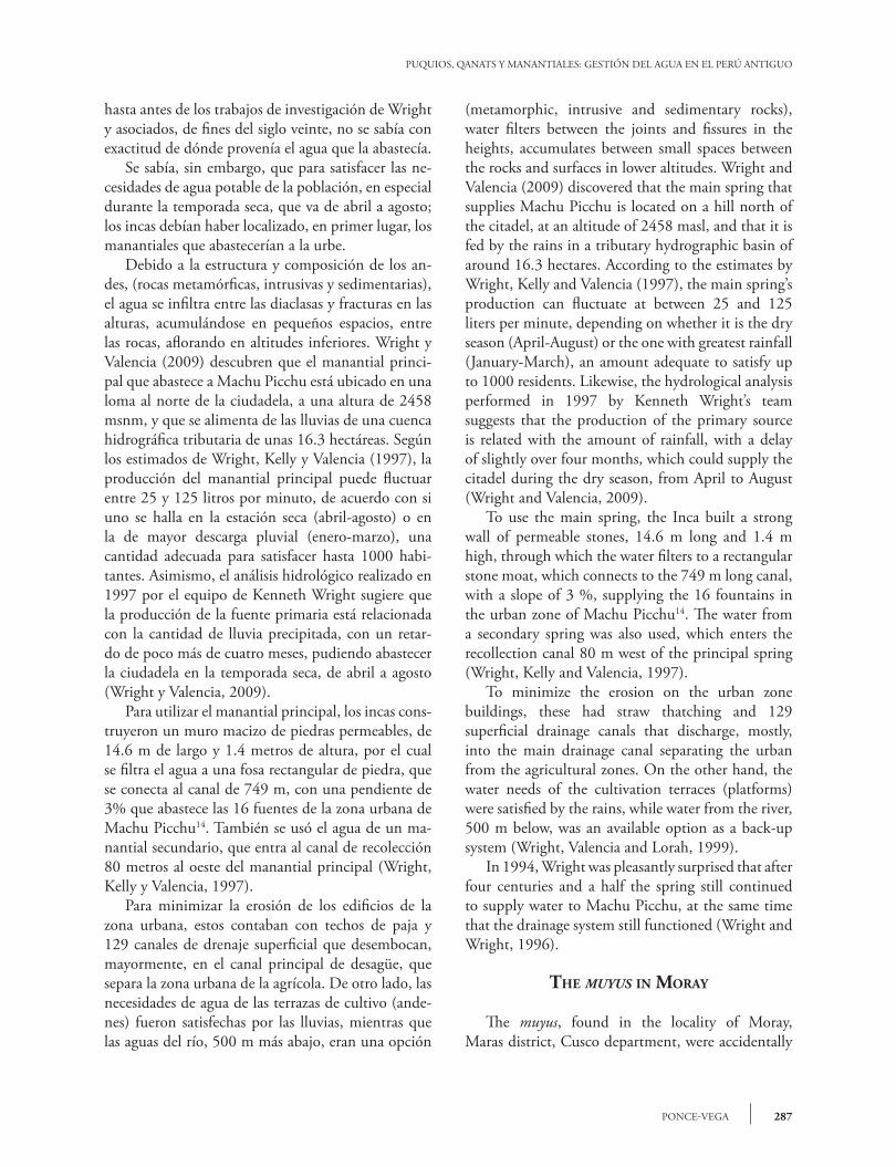
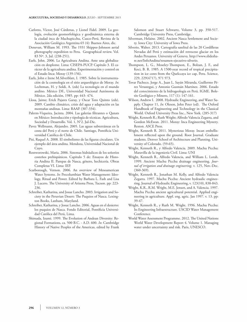
Los muyus, ubicados en la localidad de Moray, distrito de Maras, departamento de Cusco, fueron descubiertos accidentalmente por Robert Shippee y George Johnson durante la expedición fotográfica aérea de 1931(Denevan, 1993). Eran cuatro agu-jeros profundos, con terrazas en forma de círculos concéntricos, en cuyo fondo se ubicaba un sumide-ro. Las 37 hectáreas del complejo donde se encuen-tran los muyus están en la pampa de Maras, a 3700 m de altura y a 32 km de la ciudad de Cusco; en la base norte del cerro Wayñuymarka, de 4100 msnm (Earls, 2006). En quechua, muyu significa redondo, circular, esférico; círculo, redondez, circunferencia o cosa redonda, según el Diccionario kkechuwa-español de Jorge Lira15. Los cuatro agujeros naturales fueron resultado de la lluvia y las corrientes subterráneas, que mode-laron la piedra kárstica y dieron forma a las cuatro dolinas16 que asemejan tazones geométricamente re-gulares. Debido a la alta concentración de sulfatos, sales y calcio soluble de la formación de Maras, las laderas de las dolinas son muy inestables; por tal razón, se construyeron andenes circulares a fin de estabilizarlas. La dolina A es la más grande, con un diámetro de 119 metros y 70 metros de profundidad. En sus 15 metros finales los incas levantaron siete andenes de forma circular para estabilizar la ladera, pero en los trece metros superiores los ocho andenes tienen for-ma de herradura, con un aspecto característico, pare-cido a un anfiteatro. Las dolinas B y C tienen menor diámetro y profundidad, pero sus laderas también lucen andenes circulares. Solo el cuarto muyu nunca fue concluido (Wright 2011). Para Wright et al. (2011) el logro más memorable de los muyus fueron los drenajes cónicos construidos en los sumideros para evitar la acumulación de sales y residuos. Siguiendo el modelo de Machu Picchu, el filtro disponía de rocas grandes al fondo, luego capas
discovered by Robert Shippee and George Johnson during an aerial photography expedition in 1931 (Denevan, 1993). They were four deep holes, with terraces in the shape of concentric circles, at whose bottom there was a gully. The 37 hectares of the complex where the muyus are located are in the Maras pampa, at 3700 m altitude and 32 km from the city of Cusco; on the northern base of the Wayñuymarka mountain, of 4100 masl (Earls, 2006). In Quechua, muyu means round, circular, spherical; circle, roundness, circumference or round thing, according to Jorge Lira’s Kkechuwa-Spanish dictionary15. The four natural holes were the result of rain and underground currents, which modelled the karstic stone and shaped the four sinkholes16 that resemble geometrically regular bowls. Because of the high concentration of sulfates, salts and soluble calcium of the Maras formation, the sinkhole hills are quite unstable; for this reason, circular platforms were built to stabilize them. Sinkhole A is the largest, with a diameter of 119 meters and 70 meters depth. In its 15 final meters, the Inca erected seven platforms with circular shape to stabilize the hillside, but in the thirteen superior meters the eight platforms have the shape of a horseshoe, with a characteristic aspect, similar to an amphitheater. Sinkholes B and C have smaller diameter and depth, but their hillsides also have circular platforms. Only the fourth muyu was never concluded (Wright 2011). For Wright et al. (2011), the most memorable achievement of the muyus were the conical drains built in the gullies to prevent the accumulation of salts and residues. Following the Machu Picchu model, the filter had large rocks at the bottom, then layers of small stones, sand to the brim, and plant soil on top for the water to infiltrate into the ground through percolation17 (Wright, 2011).
fRom cAvIty to cAvIty
The rain precipitation in the zone, of 500 mm annual average, were infiltrated into a high terrain of 800 square meters, feeding three springs in the Wayñuymarka Mountain that could produce 150 liters of water per minute, led to Moray through two canals (north and east), being stored in two stone reservoirs, with an estimated capacity of 339.8 cubic meters (Wright et al., 2011).

289PONCE-VEGA
PUQUIOS, QANATS Y MANANTIALES: GESTIÓN DEL AGUA EN EL PERÚ ANTIGUO
de piedras pequeñas, arena al tope y encima tierra vegetal para que el agua se infiltrara en el suelo por percolación17 (Wright, 2011).
de cAvIdAd en cAvIdAd
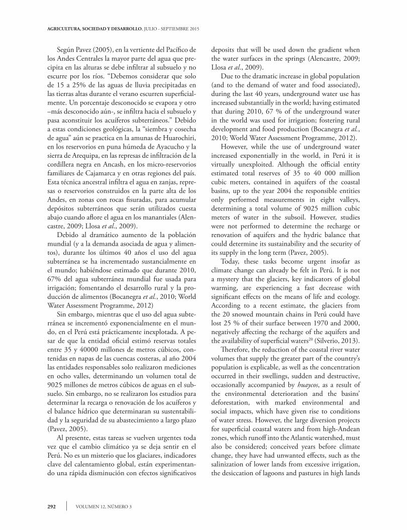
Las precipitaciones pluviales de la zona, de 500 mm promedio anual, se infiltraban en un terreno elevado de media milla cuadrada, alimentando a tres manantiales de la montaña Wayñuymarka que po-dían producir 150 litros de agua por minuto, con-ducidos a Moray por medio de dos canales (norte y este), almacenándose en dos reservorios de piedra, con una capacidad estimada de 339.8 metros cúbicos (Wright et al., 2011). Para proteger las terrazas circulares (o andenes), los muyus contaban con 27 canales de piedra, alinea-dos verticalmente en una dirección, a lo largo de una línea imaginaria que concluía en el sumidero. De acuerdo con propósitos ceremoniales, el agua de los reservorios se acarreaba hacia los canales de piedra que descendían de terraza en terraza, conduciendo ordenadamente el agua, desde el nivel superior hasta el fondo, infiltrándose en el sumidero18 (Wright et al., 2011). La eficiencia del sistema es admirable; en especial si se estima que el complejo fue construido entre el siglo XVI e inicios del XVI y que fue abandonado
In order to protect the circular terraces (or platforms), the muyus had 27 stone canals, aligned vertically in one direction, along an imaginary line that ended in the gully. In agreement with ceremonial purposes, water from the reservoirs was carried towards the stone canals that descended from terrace to terrace, leading the water in an orderly way, from the top level to the bottom, filtering into the gully18 (Wright et al., 2011). The efficiency of the system is admirable, especially if it is estimated that the complex was built between the 16th Century and the beginning of the 17th Century, and then abandoned in 1534. It is surprising that after four centuries of exposure to a difficult environment, the hills still look healthy and that the bottom of the muyu is still free of salts and erosion. For these reasons, Kenneth Wright (2011) affirmed that in the locality of Moray, where the muyus are located, a topographic change was executed, with capturing canals and storage reservoirs and regulation: with monumental terraces and conical filters that beautified and stabilized the hills and the bottom of the muyus, creating a masterwork of environmental art. In sum, the Moray muyus give us a general idea of the Andean vision, of how the rainwater that filters into the sinkholes and fractures in the Andes gives place to springs whose current is led to accumulate in
Figura 4. Muyus de la localidad de Moray, distrito de Maras, departamento de Cusco, Perú (www.hidraulicainca.com). A la derecha, ubicación de Moray (maps.google.com).
Figure 4. Muyus from the location of Moray, district of Maras, department of Cusco, Perú (www.hidraulicainca.com). To the right, location of Moray (maps.google.com).

AGRICULTURA, SOCIEDAD Y DESARROLLO, JULIO - SEPTIEMBRE 2015
VOLUMEN 12, NÚMERO 3290
en 1534. Es sorprendente que después de cuatro si-glos de exposición a un entorno difícil las laderas aún luzcan saludables y que el fondo del muyu aún se mantenga libre de sales y erosiones. Por estas razones, Kenneth Wright (2011) afirma que en la localidad de Moray, donde se ubican los muyus, se ejecutó un cambio topográfico, con canales de captación y reser-vorios de almacenamiento y regulación: con terrazas monumentales y filtros cónicos que embellecieron y estabilizaron las laderas y el fondo de los muyus, creando una obra maestra de arte ambiental. En síntesis, los mullus de Moray nos dan un grue-sa idea de la visión andina; de cómo el agua de lluvia que se infiltra en las diaclasas y fracturas de los andes da lugar a manantiales cuya corriente es conducida para acumularse en reservorios, a partir de los cuales será dirigida, de andén en andén, hasta el fondo del muyu para acabar, finalmente, en otra cavidad subte-rránea (Wright, 2011). Estos logros no deben ser subestimados. Como lo indican Earls y Silverblatt (1985) al referirse al legado de los incas: “Las grandes obras de la ingeniería agro-nómica junto con una tecnología sofisticada de logís-tica y comunicaciones presupone la existencia de un cuerpo de conocimientos científicos bien avanzados.
reservoirs, from which it will be led, from platform to platform, to the bottom of the muyu to finally end in another underground cavity (Wright, 2011). These achievements must not be underestimated. As Earls and Silverblatt (1985) indicate, when referring to the Incan legacy: “The large works of agronomic engineering, together with the sophisticated technology of logistics and communications presupposes the existence of a body of well-advanced scientific knowledge. We must assume that this science would continue to develop in different stages throughout Andean history”.
clImAte chAnge And the wAteR we do not see
The integral management of water is an important legacy of civilizations from ancient Perú, but it can also be the guiding thread of farmers’ progress in highlands and deserts. Underground water plays a relevant role, not only because it is part of the hydrogeologic cycle, but also because it gives support to several ecological functions and services, a priceless function in a future marked by climate change and water stress. Perú’s potential in terms of underground water is huge,
Figura 5. Muyus de la localidad de Moray, (ver Wright, 2008). A la derecha, detalle de la ubicación de las principales edificaciones del complejo (Wright, 2011).
Figure 5. Muyus from the location of Moray, (ver Wright, 2008). To the right, detail of the location of the main buildings of the complex (Wright, 2011).

291PONCE-VEGA
PUQUIOS, QANATS Y MANANTIALES: GESTIÓN DEL AGUA EN EL PERÚ ANTIGUO
Debemos suponer que esta ciencia siguiera desarro-llándose en diferentes etapas a través de la historia andina”.
el cAmbIo clImátIco y el AguA Que no vemos
La gestión integral del agua es un importante le-gado de las civilizaciones del antiguo Perú; pero tam-bién puede ser el hilo conductor del progreso de los agricultores de las tierras altas y de los desiertos. Las aguas subterráneas juegan un rol relevante, no solo porque forman parte del ciclo hidrogeológico, sino porque dan soporte a varias funciones y servicios ecológicos, función inapreciable en un futuro mar-cado por el cambio climático y el estrés hídrico. El potencial del Perú en materia de aguas subterráneas es enorme pues, debido a la tectónica de placas, en la cordillera de los Andes se ha formado uno de los mayores espesores del sial de la corteza terrestre; un sistema de pliegues, fracturas, espacios litológicos y sus conductos que constituyen, en conjunto, reser-vorios naturales, de capacidades gigantescas, para el almacenamiento de agua subterránea (Tovar et al., 2006). En el norte y el nororiente del Perú existen acuí-feros kársticos cuyo aporte al sistema hidrográfico regional es notable. En el centro del país los estratos aluviales rellenan los valles interandinos y las plani-cies alto-andinas, conformando acuíferos más pro-ductivos, pero al sur, las rocas volcánicas y volcánico-sedimentarias conforman un gran reservorio de agua subterránea, un inmenso acuífero de mediana per-meabilidad que constituye un aporte permanente a los ríos que lo drenan y que discurren hacia el océano Pacífico, la Amazonía y la cuenca del Titicaca. Sus estratos se extienden desde el sur de Ayacucho, a lo largo del altiplano, hasta la frontera con Chile y Bo-livia19 (Tovar et al., 2006). La recarga de los acuíferos se realiza por la infil-tración de las lluvias que se producen en las tierras al-tas, en los sedimentos porosos fluvio-morrénicos que rodean los nevados, en las cenizas volcánicas y en las turberas y lagunas, como lo demuestran los estudios isotópicos. Igualmente, por infiltración en el lecho de los ríos, en los canales y en las áreas agrícolas bajo rie-go, así como por las sub-corrientes subterráneas ge-neradas por la infiltración en las alturas (Pavez, 2005; Tovar et al., 2006).
because due to plate tectonics, one of the largest sial densities of the terrestrial cortex has formed in the Andes Mountains; a system of folds, fractures, lithology spaces and channels which constitute, as a whole, natural reservoirs of enormous capacity for underground water storage (Tovar et al., 2006). In the north and northeast of Perú there are karstic aquifers that make notable contributions to the regional hydrographic system. In the center of the country the alluvial strata fill the inter-Andean valleys and the high-Andean plains, conforming more productive aquifers, but to the south, the volcanic and volcanic-sediment rocks make up a large underground water reservoir, an immense aquifer of mid-permeability that constitutes a permanent contribution to the rivers that drain it and that flow towards the Pacific Ocean, the Amazon, and the Titicaca River basin. Their strata extend from south of the Ayacucho, along the highlands, to the border with Chile and Bolivia19 (Tovar et al., 2006). The aquifer recharge is carried out through infiltration of rainfall that is produced in the high lands, in the porous fluvio-moraine sediments that surround the snow peaks, in volcanic ashes, and in peat bogs and lagoons, as isotopic studies show. Likewise, it happens through infiltration in the riverbed, in the canals and in the irrigated agricultural areas, as well as from the underground sub-currents generated by infiltration in the heights (Pavez, 2005; Tovar et al., 2006). According to Pavez (2005), in the Pacific gradient of the Central Andes, most of the water that precipitates in the heights must filter into the subsoil and does not runoff from the rivers. “We must consider that only 15 to 25 % of the rainfall water on the highlands during the summer runs off superficially. An unknown percentage is evaporated and another –yet more unknown– is filtered towards the subsoil and moves on to constitute the underground aquifers.” Because of these geological conditions, the “sowing and harvesting of water” is still practiced in the Huarochiri amunas, in the reservoirs of the moist Ayacucho puna and the Arequipa Sierra, in the infiltration dams of the black Ancash mountain chain, in the Cajamarca family micro-reservoirs, and in other regions of the country. This ancestral technique filters water in ditches, dams or reservoirs built in the high parts of the Andes, in zones with fissured rocks, to accumulate underground
AGRICULTURA, SOCIEDAD Y DESARROLLO, JULIO - SEPTIEMBRE 2015
VOLUMEN 12, NÚMERO 3292
Según Pavez (2005), en la vertiente del Pacífico de los Andes Centrales la mayor parte del agua que pre-cipita en las alturas se debe infiltrar al subsuelo y no escurre por los ríos. “Debemos considerar que solo de 15 a 25% de las aguas de lluvia precipitadas en las tierras altas durante el verano escurren superficial-mente. Un porcentaje desconocido se evapora y otro –más desconocido aún-, se infiltra hacia el subsuelo y pasa aconstituir los acuíferos subterráneos.” Debido a estas condiciones geológicas, la “siembra y cosecha de agua” aún se practica en la amunas de Huarochiri, en los reservorios en puna húmeda de Ayacucho y la sierra de Arequipa, en las represas de infiltración de la cordillera negra en Ancash, en los micro-reservorios familiares de Cajamarca y en otras regiones del país. Esta técnica ancestral infiltra el agua en zanjas, repre-sas o reservorios construidos en la parte alta de los Andes, en zonas con rocas fisuradas, para acumular depósitos subterráneos que serán utilizados cuesta abajo cuando aflore el agua en los manantiales (Alen-castre, 2009; Llosa et al., 2009). Debido al dramático aumento de la población mundial (y a la demanda asociada de agua y alimen-tos), durante los últimos 40 años el uso del agua subterránea se ha incrementado sustancialmente en el mundo; habiéndose estimado que durante 2010, 67% del agua subterránea mundial fue usada para irrigación; fomentando el desarrollo rural y la pro-ducción de alimentos (Bocanegra et al., 2010; World Water Assessment Programme, 2012) Sin embargo, mientras que el uso del agua subte-rránea se incrementó exponencialmente en el mun-do, en el Perú está prácticamente inexplotada. A pe-sar de que la entidad oficial estimó reservas totales entre 35 y 40000 millones de metros cúbicos, con-tenidas en napas de las cuencas costeras, al año 2004 las entidades responsables solo realizaron mediciones en ocho valles, determinando un volumen total de 9025 millones de metros cúbicos de aguas en el sub-suelo. Sin embargo, no se realizaron los estudios para determinar la recarga o renovación de los acuíferos y el balance hídrico que determinaran su sustentabili-dad y la seguridad de su abastecimiento a largo plazo (Pavez, 2005). Al presente, estas tareas se vuelven urgentes toda vez que el cambio climático ya se deja sentir en el Perú. No es un misterio que los glaciares, indicadores clave del calentamiento global, están experimentan-do una rápida disminución con efectos significativos
deposits that will be used down the gradient when the water surfaces in the springs (Alencastre, 2009; Llosa et al., 2009). Due to the dramatic increase in global population (and to the demand of water and food associated), during the last 40 years, underground water use has increased substantially in the world; having estimated that during 2010, 67 % of the underground water in the world was used for irrigation; fostering rural development and food production (Bocanegra et al., 2010; World Water Assessment Programme, 2012). However, while the use of underground water increased exponentially in the world, in Perú it is virtually unexploited. Although the official entity estimated total reserves of 35 to 40 000 million cubic meters, contained in aquifers of the coastal basins, up to the year 2004 the responsible entities only performed measurements in eight valleys, determining a total volume of 9025 million cubic meters of water in the subsoil. However, studies were not performed to determine the recharge or renovation of aquifers and the hydric balance that could determine its sustainability and the security of its supply in the long term (Pavez, 2005). Today, these tasks become urgent insofar as climate change can already be felt in Perú. It is not a mystery that the glaciers, key indicators of global warming, are experiencing a fast decrease with significant effects on the means of life and ecology. According to a recent estimate, the glaciers from the 20 snowed mountain chains in Perú could have lost 25 % of their surface between 1970 and 2000, negatively affecting the recharge of the aquifers and the availability of superficial waters20 (Silverio, 2013). Therefore, the reduction of the coastal river water volumes that supply the greater part of the country’s population is explicable, as well as the concentration occurred in their swellings, sudden and destructive, occasionally accompanied by huaycos, as a result of the environmental deterioration and the basins’ deforestation, with marked environmental and social impacts, which have given rise to conditions of water stress. However, the large diversion projects for superficial coastal waters and from high-Andean zones, which runoff into the Atlantic watershed, must also be considered; conceived years before climate change, they have had unwanted effects, such as the salinization of lower lands from excessive irrigation, the desiccation of lagoons and pastures in high lands
293PONCE-VEGA
PUQUIOS, QANATS Y MANANTIALES: GESTIÓN DEL AGUA EN EL PERÚ ANTIGUO
sobre los medios de vida y la ecología. Según un re-ciente estimado, los glaciares de las 20 cordilleras ne-vadas del Perú podrían haber perdido 25% de su su-perficie entre 1970 y 2000, afectando negativamente la recarga de los acuíferos y la disponibilidad de las aguas superficiales20 (Silverio, 2013). Por lo tanto, la reducción del caudal de los ríos de la costa que abastecen a la mayor parte de la pobla-ción del país es explicable, al igual que la concentra-ción ocurrida en sus crecidas, súbitas y destructivas, ocasionalmente acompañadas de huaycos, como re-sultado del deterioro ambiental y la deforestación de las cuencas, con acentuados impactos ambientales y sociales, que han dado lugar a condiciones de estrés hídrico. Sin embargo, también se deben considerar los grandes proyectos de trasvase de aguas superficia-les costeras y de las zonas alto-andinas, que escurren a la vertiente del Atlántico; concebidos años antes del cambio climático, han traído efectos no deseados, como la salinización de las tierras bajas por sobre-irrigación, el desecamiento de lagunas y bofedales en las tierras altas y conflictos por el agua entre cuencas vecinas y con las comunidades (Pavez, 2005). Bajo estas condiciones, urge asegurar el suminis-tro de agua y priorizar la gestión integral de cuen-cas, la diversificación de las fuentes de captación y el fomento de las técnicas tradicionales, junto con el riego tecnificado pero, en especial, la realización de estudios isotópicos y la teledetección de aguas subte-rráneas por satélite.
conclusIones
Dada la sequedad del ambiente y la morfología de los suelos de Nasca, el sistema de puquios ha sido y es una solución eficiente, sustentable y con un costo accesible que merece potenciarse con tecnología de punta, privilegiando los estudios de aguas subterrá-neas. Los puquios que abastecen a Nasca se alimentan de las aguas subterráneas. Igualmente, tanto Machu Picchu como los muyus de Moray y los diferentes casos de siembra y cosecha de agua que se han im-plementado en las cuencas del Perú se abastecen de aguas subterráneas o manantiales. Por lo tanto, re-sulta importante realizar estudios sobre estas aguas, cuyos resultados servirán para potenciar los sistemas tradicionales, en el contexto de una gestión integrada de cuencas.
and conflicts over water between neighboring basins and with the communities (Pavez, 2005). Under these conditions, it is urgent to guarantee the water supply and to prioritize the integral management of basins, the diversification of catchment sources, and the promotion of traditional techniques together with technical irrigation but, especially, the development of isotopic studies and the tele-detection of underground waters with satellites.
conclusIons
Given the dryness of the environment and the morphology of the soils at Nasca, the puquio system has been and still is an efficient, sustainable solution with an accessible cost that deserves to be strengthened with cutting-edge technology, favoring the studies of underground water. The puquios that supply Nasca are fed from underground waters. Likewise, both Machu Picchu and the Moray muyus and the different cases of sowing and harvesting water that have been implemented in Perú’s basins are supplied with underground water or springs. Therefore, it is important to perform studies about these waters, whose results would serve to strengthen traditional systems, within the context of an integrated basin management. We hope that these lines will awaken the intellectual curiosity of young people and the interest of policy makers, so that traditional knowledge can be strengthened with cutting-edge technology in order to successfully face poverty, water stress and global warming.
- End of the English version -
Se espera que las presentes líneas despierten la curiosidad intelectual de los jóvenes y el interés de los formuladores de política, de manera tal que los conocimientos tradicionales se puedan potenciar con tecnologías de punta, a fin de enfrentar con éxito la pobreza, el estrés hídrico y el calentamiento global.
notAs
1Vernon Scarborough (2006: 233) afirma textual-mente lo siguiente: “Barnes and Fleming (1991)
AGRICULTURA, SOCIEDAD Y DESARROLLO, JULIO - SEPTIEMBRE 2015
VOLUMEN 12, NÚMERO 3294
work in Chile with ancient tunnel wells (puquios) suggests a Spanish origin for this ingenious, com-plicated, and unique water system, but Schreiber and Lancho Rojas (1993, 2003) argue otherwise.” u Vernon Scarborough (2006: 233) states literally the following: “Barnes and Fleming (1991) work in Chile with ancient tunnel wells (puquios) suggests a Spanish origin for this ingenious, complicated, and unique water system, but Schreiber and Lancho Ro-jas (1993, 2003) argue otherwise.”2Gonçález Holguín, Diego. Vocabulario de la Lengua General de todo el Perú, llamada Lengua Quichua o del Inca. Lima, imprenta de Francisco del Can-to, 1952, [1608]. (pags. 197 y 329). u Gonçález Holguín, Diego. Vocabulario de la Lengua Gener-al de todo el Perú, llamada Lengua Quichua o del Inca. Lima, imprenta de Francisco del Canto, 1952, [1608]. (pp. 197 and 329).3Santo Tomás, Domingo de, Gramática o arte de la lengua general de los indios de los reinos del Perú, 207p. ; Lima: Instituto de Historia, UNMSM. 1951 [1560]. u Santo Tomás, Domingo de, Gramática o arte de la lengua general de los indios de los reinos del Perú, 207p. ; Lima: Instituto de Historia, UNMSM. 1951 [1560].4Los ríos Santa Cruz, Palpa, Viscas e Ingenio están al norte, mientras que los ríos Aja, Tierras Blancas, Taru-ga y las Trancas se hallan al sur; debiéndose relevar que los ríos Tierras Blancas y Aja se unen para conformar el río Nasca. u The rivers Santa Cruz, Palpa, Viscas and Ingenio are to the north, while the rivers Aja, Tier-ras Blancas, Taruga and Las Trancas are to the south; it should be mentioned that the rivers Tierras Blancas and Aja unite to make up the river Nasca.5Las que se buscan y alumbran en las márgenes o de-bajo de cauces empobrecidos o secos de los ríos. Pa-lerm Viqueira (2004) se basa en Bertrand y Cressier (1985) para realizar la comparación con las cimbras. u They are sought for and surface on the margins or under poor or dry river beds. Palerm Viqueira (2004) takes up Bertrand and Cressier (1985) to make the comparison with the scaffolds.6Schreiber y Lancho, (2006) señalan que la mayor parte de los puquios se abastecen de las corrientes subterráneas de los ríos. u Schreiber and Lancho (2006) point out that most of the puquios are sup-plied from the underground river currents.7En el caso específico del pueblo de Nasca, el sub-estrato sub-superficial está a 2.5 metros de los de-
pósitos aluviales consolidados. (Barnes y Fleming, 1991). u In the specific case of the town of Nasca, the sub-superficial sub-stratum is at 2.5 meters from the consolidated alluvial deposits (Barnes and Flem-ing, 1991).8De los datos de la Junta de Usuarios del Sub-Distrito de Riego Nasca, Berghuber y Vogl (2005) registraron cinco puquios en el Sector de Riego Nasca - Comisión de Regantes Nasca Alto, 25 en la zona de las Comi-siones de Regantes Aja y Tierras Blancas del mismo Sector de Riego, dos en el Sector de Riego Las Trancas - Comisión de Regantes Taruga y cinco en la zona de la Comisión de Regantes Trancas Alto. u Of the data from the Nasca Irrigation Sub-District Users’ Board, Berghuber and Vogl (2005) recorded five puquios in the Nasca Irrigation Sector – High Nasca Irrigators Commission, 25, in the zone of the Aja and Tierras Blancas Irrigators Commissions from the same Irriga-tion Sector, two in the Las Trancas Irrigation Sector - Taruga Irrigators Commission and five in the zone of the Trancas Alto Irrigators Commission.9El nombre científico de la especie es: “Prosopis palli-da” y su nombre común es: “Algarrobo” en la Costa Norte y Central del Perú y “Huarango” en el Depar-tamento de Ica. La especie puede llegar a 18 metros de altura y a 2 metros de ancho, las raíces pueden penetrar hasta 50 metros bajo tierra. Son ideales para proveer leña y madera para construcción. Beresford-Jones, David G.; Susana Arce T, Oliver Q Whaley, Alex J Chepstow-Lusty.” (2009). u The scientific name of the species is Prosopis pallida, and its com-mon name is “algarrobo” on Perú’s northern and cen-tral coast, and “huarango” in the Ica department. The species can reach 18 meters of height and 2 meters of width, the roots can penetrate up to 50 meters underground. They are ideal to provide firewood and construction wood. Beresford-Jones, David G., Susana Arce T, Oliver Q Whaley, Alex J Chepstow-Lusty (2009).10Al comparar los puquios de Nasca con estructuras similares en otras áreas del mundo, Barnes y Fle-ming (1991: 51) hallaron que las galerías filtrantes de Madrid, Pica, Nor-Africa, son altas y estrechas, con techos arqueados. u When comparing the Nasca puquios with similar structures in other areas of the world, Barnes and Fleming (1991:51) found that the filtering galleries of Madrid, Pica, North Africa, are tall and narrow, with arched roofs.11A más profundidad, más largo será el canal; a mayor
295PONCE-VEGA
PUQUIOS, QANATS Y MANANTIALES: GESTIÓN DEL AGUA EN EL PERÚ ANTIGUO
pendiente, más corto será el canal. u At a greater depth, the canal will be longer; at a greater slope, the canal will be shorter.12El torreón, junto con la Intihuatana y el Templo de la Luna, están entre las edificaciones más distintivas de Machu Picchu. u The turret, together with the Intihuatana and the Moon Temple, are among the most distinctive edifications of Machu Picchu.13Gracias al Centro Byrd de Investigación Polar de la Universidad Estatal de Ohio, Wright y asociados (1997) obtuvieron la precipitación pluvial promedio por décadas, desde 1450 hasta 1540. La precipitación promedio anual del periodo 1450-1500 fue de 1,830 mm, mientras que la precipitación pluvial del perio-do 1500-1540 fue de 2,090 mm. Esta información se basa en los estudios de Thompson et al. (1985) de las capas de hielo y glaciares del nevado Quelccaya, ubi-cado a 250 kilómetros al sureste de Machu Picchu. u Thanks to the Byrd Polar and Climate Research Center from the Ohio State University, Wright and associates (1997) obtained the average rain precipi-tation per decade, from 1450 to 1540. The annual average precipitation in the 1450-1500 period was 1,830 mm, while the rain precipitation in the 1500-1540 period was 2,090 mm. This information is based on the studies by Thompson et al. (1985) on the ice and glacier layers of the Quelccaya peak, lo-cated 250 kilometers southeast of Machu Picchu.14Para las labores de mantenimiento, construyeron una terraza de 1.5 a 2.0 metros de ancho que daba un fácil acceso a la base del muro. u For the mainte-For the mainte-nance tasks, they built a terrace of 1.5 to 2.9 meters wide that gave easy access to the base of the wall.15Jorge Lira, Diccionario kechuwa-español. Univer-sidad Nacional de Tucumán, Departamento de In-vestigaciones Regionales, Instituto de Historia, Lin-güística y Folklore: Cusco y Tucumán, 1944, p. 683. Citado por Pisi, 2008. u Jorge Lira, Diccionario ke-Jorge Lira, Diccionario ke-chuwa-español. Universidad Nacional de Tucumán, Departamento de Investigaciones Regionales, In-stituto de Historia, Lingüística y Folklore: Cusco y Tucumán, 1944, p. 683. Cited by Pisi, 2008.16Dolinas, depresión cónica formada por el hundi-miento de un terreno calizo. u Sinkholes, conical de-Sinkholes, conical de-pression formed by the sinking of limestone territory.17Percolar, atravesar las aguas con movimiento lento un material poroso ya saturado. Hacer pasar un líqui-do a través de una masa polvorienta con el fin de disol-ver sus principios activos. Diccionario de Arquitectura
y Construcción. u Percolating, crossing the water with a slow movement in a porous material that is already saturated. A liquid must be made to move through a dusty mass with the aim of dissolving its active principles. Diccionario de Arquitectura y Con-strucción.18Earls tiene una opinión diferente. Para él Moray era una estación agrícola experimental. u Earls has a different opinion. To him, Moray was an experimen-tal agricultural station.19De los acuíferos que se hallan en la zona altiplánica, los acuíferos fisurados clásticos son los más importan-tes y están ubicados mayormente hacia el lado Oeste de la cordillera Occidental. u Of the aquifers found in the Highland zone, the clastic fissured aquifers are the most important and they are located mostly to-wards the West of the Eastern mountain chain.20En 1970, las 20 cordilleras nevadas registraron una superficie de 2076.85 km2, que representó 70% de los glaciares tropicales. En 2000 cubrían una super-ficie de 1559 km2. Es decir, en los últimos 30 años el retroceso glaciar fue de 17.3 km2 /año. u In 1970, the 20 snowed mountain chains recorded a surface of 2076.85 km2, which represented 70% of the tropical glaciers. In 2000, they covered a surface of 1559 km2. That is, in the last 30 years the glacial retreat has been of 17.3 km2 /year.
lIteRAtuRA cItAdA
Alencastre, Andrés. 2009. Las amunas. Recarga del acuífero en los Andes. La gestión social del agua en Tupicocha, Huaro-chirí. Lima Provincias. In: Llosa, Jaime; Erick Pajares Garay y Oscar Toro Quinto (eds). Cambio climático, crisis del agua y adaptación en las montañas andinas. Lima: RAAP. (307-334).
Barnes, Monica, and David Fleming. 1991. Filtration-gallery irrigation in the Spanish New World. Latin American Anti-quity vol. 2, num. 1, (march). pp: 48-68.
Beresford-Jones, David G.; Susana Arce T, Oliver Q Whaley, and Alex J Chepstow-Lusty. 2009. The Role of Prosopis in eco-logical and landscape change in the Samaca Basin, lower Ica Valley, south coast Peru from the early horizon to the late in-termediate period. Latin American Antiquity. pp: 303-332.
Berghuber, Konrad, y Christian R. Vogl. 2005. Descripción y Análisis de los Puquios como Tecnología Adaptada para la Irrigación en Nasca, Perú. Zonas Áridas Nº9: 35-50.
Bocanegra, Emilia, Gerson C. da Silva Jr., Emilio Custodio, Marisol Manzano, and Suzana Montenegro. 2010. State of knowledge of coastal aquifer management in South America. Hidrogeological Journal (2010) 18: 261-267.
Canziani Amico, José. 2007. Paisajes Culturales y Desarrollo Te-rritorial en los Andes. Arquitectura y Ciudad. PUCP. Cua-dernos N°5. Octubre. 121 p.
AGRICULTURA, SOCIEDAD Y DESARROLLO, JULIO - SEPTIEMBRE 2015
VOLUMEN 12, NÚMERO 3296
Carlotto, Víctor, José Cárdenas, y Lionel Fidel. 2009. La geo-logía, evolución geomorfológica y geodinámica externa de la ciudad inca de Machupicchu, Cusco-Perú. Revista de la Asociación Geológica Argentina 65 (4): Buenos Aires, dic.
Denevan, William M. 1993. The 1931 Shippee-Johnson aerial photography expedition to Peru. Geographical review. Vol. 83 Nº. 3, Jul. (238-251).
Earls, John. 2006. La Agricultura Andina. Ante una globaliza-ción en desplome. Lima: CISEPA-PUCP. Capítulo 3. El ca-rácter de la agricultura andina. Experimentación y control en el Estado Inca: Moray (139-156).
Earls, John e Irene M.Silverblatt, I. 1985. Sobre la instrumenta-ción de la cosmología en el sitio arqueológico de Moray. In: Lechtman, H. y Soldi, A. (eds) La tecnología en el mundo andino. México DF., Universidad Nacional Autónoma de México. 2da edición, 1985. pp: 443- 474.
Llosa, Jaime; Erick Pajares Garay, y Oscar Toro Quinto (eds). 2009. Cambio climático, crisis del agua y adaptación en las montañas andinas. Lima: RAAP. (307-334).
Palerm-Viqueira, Jacinta. 2004. Las galerías filtrantes o Qanats en México: Introducción y tipología de técnicas. Agricultura, Sociedad y Desarrollo. Vol. 1, N°2. Jul-Dic.
Pavez Wellmann, Alejandro. 2005. Las aguas subterráneas en la costa del Perú y el norte de Chile. Santiago, Pontificia Uni-versidad Católica de Chile.
Pisi, Raquel A. 2008. El simbolismo de las figuras circulares. Un ejemplo del área andina. Mendoza, Universidad Nacional de Cuyo.
Rostworowski, Maria. 2006. Sistemas hidráulicos de los señoríos costeños prehispánicos. Capítulo 5 de: Ensayos de Histo-ria Andina II. Pampas de Nasca, género, hechicería. Obras Completas VI. Lima: IEP.
Scarborough, Vernon. 2006. An overview of Mesoamerican Water Systems. In: Precolumbian Water Management: Ideo-logy, Ritual and Power. Edited by Barbara L. Fash and Lisa J. Lucero. The University of Arizona Press, Tucson. pp: 223-236.
Schreiber, Katharina, and Josue Lancho. 2003. Irrigation and So-ciety in the Peruvian Desert: The Puquios of Nasca. Lexing-ton Books, Lanham, Maryland.
Schreiber, Katharina, y Josue Lancho. 2006. Aguas en el desierto: los puquios de Nasca. Fondo Editorial, Pontificia Universi-dad Católica del Perú, Lima.
Shimada, Izumi. 1999. The Evolution of Andean Diversity: Re-gional Formations, ca. 500 B.C. - A.D. 600. In: Cambridge History of Native Peoples of the Americas, edited by Frank
Salomon and Stuart Schwartz, Volume 3, pp. 350-517. Cambridge University Press, Cambridge.
Silverman, Helaine. 2002. Ancient Nasca Settlement and Socie-ty. Iowa City: University of Iowa Press.
Silverio, Walter. 2013. Cartografía satelital de las 20 Cordilleras Nevadas del Perú y estimación del retroceso glaciar en los Andes Peruanos. University of Geneva. http://www.slidesha-re.net/InfoAndina/resumen-ejecutivo-silverio.
Thompson, L. G., Moseley-Thompson, E., Bolzan, J. F., and Koci, B. R. 1985. A 1500-year record of tropical precipita-tion in ice cores from the Quelccaya ice cap, Peru. Science, 229, 229(4717), 971 973.
Tovar Pacheco, Jorge A., Juan L. Sayán Miranda, Guillermo Pé-rez Verastegui, y Antonio Guzmán Martínez. 2006. Estado del conocimiento de la hidrogeología en Perú. IGME. Bole-tín Geológico y Minero, 117 (1): 147-161.
Wilson, Andrew I. 2008. Hydraulic Engineering, and Water Su-pply. Chapter 11, In: Oleson, John Peter (ed). The Oxford Handbook of Engineering and Technology in the Classical World. Oxford University Press Inc., New York. (285-317)
Wright, Kenneth R.; Ruth Wright; Alfredo Valencia Zegarra, and Gordon McEwan. 2011. Moray: Inca Engineering Mystery. Reston. ASCE Press.
Wright, Kenneth R. 2011. Mysterious Moray. Incan embellis-hment reflected upon the ground. Root Journal. Graduate students. Denver School of Architecture and Planning. Uni-versity of Colorado. (59-65).
Wright, Kenneth R., y Alfredo Valencia. 2009. Machu Picchu: Maravilla de la ingeniería Civil. Lima: UNI
Wright, Kenneth R., Alfredo Valencia, and William L. Lorah. 1999. Ancient Machu Picchu drainage engineering. Jour-nal of irrigation and drainage engineering, v. 125, Nov.-Dec. (360-369).
Wright, Kenneth R., Jonathan M. Kelly, and Alfredo Valencia Zegarra. 1997. Machu Picchu: Ancient hydraulic enginee-ring. Journal of Hydraulic Engineering, v. 123(10), 838- 843.
Wright, K.R., R.M. Wright, M.E. Jensen, and A. Valencia. 1997. Machu Picchu ancient agricultural potential. Applied engi-neering in agriculture. Appl. eng. agric. Jan 1997. v. 13. pp: 39-47.
Wright, Kenneth R., y Ruth M. Wright. 1996. Machu Picchu: Its Engineering Infraestructure. USCID Water Management Conference.
World Water Assessment Programme. 2012. The United Nations World Water Development Report 4. Volume 1. Managing water under uncertainty and risk. Paris, UNESCO.