Rodríguez Méndez, Francisco Javier y García Gago, Jesús ...
10
WYNGAERDE IN ZAMORA Rodríguez Méndez, Francisco Javier y García Gago, Jesús María. 2014. “Wyngaerde en Zamora”. EGE Revista de Expresión Gráfica en la Edificación. Nº 8. P. 67-75 y 141-145. ISSN: 1888-8143 1 WYNGAERDE IN ZAMORA Francisco Javier Rodríguez Méndez. University of Salamanca. Jesús María García Gago. University of Salamanca. ABSTRACT Flemish cartographer Anton Van den Wyngaerde was commissioned by Philip II to gather panoramic sketches of the major Spanish cities and towns. Between 1562 and 1570, Wyngaerde explored the peninsula's geography on three different trips, resulting in 57 panoramas in almost as many locations. In 1986, the book “Spanish Cities of the Golden Age” made Antonio de las Viñas’ Spanish views known and since then, many researchers have gazed through these open windows into the past. To achieve a perfect representation, Wyngaerde included some of the typical repertoire of techniques in his View of Zamora: combining a range of perspectives, elevation to unrealistic heights... These techniques are analyzed in this paper using geometric restitution of perspective, virtually reconstructing the city of Zamora in the 16th century and using aerial photography. Keywords (max. 4): Wyngaerde, Chorography, Geometric restitution of perspective, Zamora.
Transcript of Rodríguez Méndez, Francisco Javier y García Gago, Jesús ...

WYNGAERDE IN ZAMORA
Rodríguez Méndez, Francisco Javier y García Gago, Jesús María. 2014. “Wyngaerde en Zamora”. EGE Revista
de Expresión Gráfica en la Edificación. Nº 8. P. 67-75 y 141-145. ISSN: 1888-8143
1
WYNGAERDE IN ZAMORA
Francisco Javier Rodríguez Méndez. University of Salamanca.
Jesús María García Gago. University of Salamanca.
ABSTRACT
Flemish cartographer Anton Van den Wyngaerde was commissioned by Philip II to gather panoramic sketches of the major Spanish cities and towns. Between 1562 and 1570, Wyngaerde explored the peninsula's geography on three different trips, resulting in 57 panoramas in almost as many locations.
In 1986, the book “Spanish Cities of the Golden Age” made Antonio de las Viñas’ Spanish views known and since then, many researchers have gazed through these open windows into the past.
To achieve a perfect representation, Wyngaerde included some of the typical repertoire of techniques in his View of Zamora: combining a range of perspectives, elevation to unrealistic heights... These techniques are analyzed in this paper using geometric restitution of perspective, virtually reconstructing the city of Zamora in the 16th century and using aerial photography.
Keywords (max. 4):
Wyngaerde, Chorography, Geometric restitution of perspective, Zamora.

WYNGAERDE IN ZAMORA
2
INTRODUCTION
In 1986 the book Spanish cities of the Golden age: the views of Anton van den Wyngaerde (1) was published in Spain. This colossal work, edited by Richard L. Kagan –its large-format and meticulous presentation increasing its price tag – did not become a bestseller but without doubt has since then become one of the most consulted and coveted reference books for the many people from different fields of knowledge who have started to explore the historical evolution of cities.
In almost all research papers on any of the cities that were sketched in the book Cities of the Golden Age (CGA), the Flemish artist is mentioned and many contain a reproduction of the relevant sketch. There are a great number of papers studying Wyngaerde’s views –as a general theme or focusing in one view in particular- as part of their archaeological, urbanistic, architectural or historical research. Here, special mention should be made of the conscientious study by Antonio Sánchez del Barrio on La estructura urbana de Medina del Campo (2) [The urban structure of Medina del Campo], in which we find a whole chapter dedicated to the two views of Medina drawn by Wyngaerde. It is also the first and one of the most serious references to Anton van den Wyngaerde since the publication of CGA.
We have come a long way with regard to the study of the view of the city of Zamora. In order to demonstrate, mention should also be made of two papers about the walls of Zamora and on the city’s
Master Plan from 1998 (3) and 2004 (4) respectively. In both papers Wyngaerde’s drawing played an important role in supporting certain interpretations regarding the walled enclosures of Zamora.
The aim of this paper is to analyze the graphical procedures used by Wyngaerde on the basis of the Southern view of the city – the only one known of Zamora.
THE SPANISH VIEWS OF
WYNGAERDE
The chronology of the life of the Anton van den Wyngaerde is rather nebulous. We only know for certain the place and year of his death: Madrid, 1571. His birth is thought to have taken place in Antwerp but the date is unkown. Anton Van den Wyngaerde was considered at that time to be one of the best cartographers specialising in urban views and from 1552 provided his services to the Spanish Crown, travelling on its behalf to Flanders and England. After a certain period of time Philip II commissioned him to visit the Iberian Peninsula and prepare the large-scale inventory of the Kingdom’s chief towns and cities. This ambitious project demanded by the Spanish king was of a strategic and military nature.
His first tour began in 1562, the second one in 1567 and the third in 1570, just one year before his early death. The three journeys commenced at the Spanish Court. In the first one he covered the cities of La Mancha, Aragon, Catalonia and the Levante. In the second he covered Extremadura and
Andalucia and finally Castille in the third.
ARRIVAL TO ZAMORA AND
PRELIMINARY WORKS
During his third and last journey in 1570, Wyngaerde started out once more from Madrid, the capital of the kingdom, to carry out views of the cities of Avila, Alba de Tormes, Tordesillas and again to Medina del Campo. The three routes have been established by Kagan in CGA on the basis of the dates appearing next to the signature of each of his views and taking into account the journey’s logic (5).
One may well imagine the arrival of the cartographer to Zamora, accompanied by his cohort of surveyors and assistants. News about him and his activities were already undoubtedly known, as many of the towns had already received his attention in previous visits for long periods of time. By 1570 a sovereign ordinance addressed to “town councils and courts, councillors, knights, officers and gentlemen of all the cities belonging to these, my realms and seigneuries of Castille” (6) required, under a penalty of 1000 maravedíes, to provide Wyngaerde and his companions with a positive reception, including food and lodging, which was to be paid for by the municipality. The necessity of such an ordinance suggests to us us he had not been provided with these up to this point.
Assuming, as Kagan states, the Flemish artist, arrived to Zamora from Salamanca, his first perspective of the city was exactly the one he depicted in his view.

WYNGAERDE IN ZAMORA
3
This should come as no surprise, as that view is the one that best expresses the impregnable character of the ancient citadel, with the river Douro dominating from the top of the cliff. Draughtsmen and photographers have always used this perspective to immortalize the city as did, for example, Muirhead Bone or J. Laurent.
In some of the panoramic views (Toro or Jaen for example) the viewpoint and line of vision are made visible by the author by including one or several characters in the act of drawing. This is not the case in the view of Zamora, where the Monastery of Saint Jerome is the element which is most prominent, being as it is in the foreground (Fig. 1). This renaissance monument was disentailed and went into private hands which precipitated its almost complete ruin. Only the foundations, buried under earth and mounds of undergrowth, remain in situ. Only the vivid picture in the view and some columns and arches of the cloister (now relocated to the atrium of the
cathedral) are left for us to see. It is quite possible that this building served as housing for Wyngaerde
and his cohorts. Logistically speaking, this was the best base they would find to prepare the panoramic view.
One can do no more than speculate regarding the time spent and the kinds of activities undertaken before creating the final view; there are no known written records bearing evidence of the draughtsman’s stay in Zamora (7). Over a period of several weeks, assistants and Wyngaerde himself most likely explored the city in depth, searching for relevant data: surveying the urban structure, identifying the most pertinent buildings, transcribing toponymic items, carrying out height measurements of the towers and other protruding elements, etc. One might well doubt somewhat whether some of these preliminary works were necessary and reach the conclusion that it was a freehand view-drawing as the characters which appear in the drawing suggest. In the case of Zamora it would not have been
possible.
The South bank of the river Douro lacks sufficient elevation (even from the top floor of the now dissapeared Convent of Saint Jerome) to provide a view from which the inner part of the city – much the less its northern slope – could be seen. Fig.2, photograph taken from the left bank, shows only the buildings closest to the rocky escarpment. For this reason Anton van den Wyngaerde would have been forced to use the routine recourse under these circumstances, i.e. to choose an imaginary point of view and an elevation convenient for his purposes.
Therefore, in these cases the view needed to be “built” by using various sketches (made by artistic observation from nature) and applying them to a floor plan of the city. The creation of preparatory drawings was a common practice for Wyngaerde, as evidenced by the large number of them belonging to other cities other than Zamora that have been preserved. We don’t know of any reliable city plan from Zamora prior to the fortification project of 1766 and it is very unlikely that any plan of sufficient quality was available two centuries before. Among the preliminary works carried out by Wyngaerde, a topographic survey of the urban area and its setting was thus certainly carried out. The objective of this paper is not to formulate hypothesis about the method employed by Wyngaerde when carrying out his preliminary document. Nontheless, from the different types of urban surveys described by Fernando Arévalo, I have opted for the simplest one
Fig. 1: View of Zamora. Detail, in the foreground, of the Monastery of San Jerónimo. Source: Kagan, R. L., op. cit., p. 370.

WYNGAERDE IN ZAMORA
4
called survey “by polygons” (8) which consists in directly measuring the different polygons forming blocks and then fit them in the walled enclosure of the city. A royal decree of 1563 (Philip II) includes a detailed description of a simple survey procedure which could very likely be the one used by Wyngaerde’s land-surveyors for obtaining the walled enclosure plan (9).
Fernando Arévalo also includes a reference to the execution of urban perspectives from the ground plan corresponding to a document from 1589. In it Cristóbal de Rojas, a military engineer of Manchegan origin, states his intention of carrying out a city plan “so that I can then paint it and draw it from nature in the style of other existing drawings of cities (10).
CITY OF ZAMORA’S VIEW
ANALYSIS
Before going on to analyse the view of Zamora, there are some common characteristics (graphic constants) repeated in almost all of the urban views drawn by Wyngaerde that must be emphasized. It seems clear that the draughtsman first depicted all of
the main buildings and major roads followed by the city’s blocks (11). Almost all the views reveal three layers, each with a declining level of detail: foreground, middle plane and background (12). It is widely accepted that the artist made direct notes about the buildings, streets and squares of the foreground and ‘built’ the rest of the city – which he could not see directly from his viewpoint – behind this “façade” (13).
Once he had a scale ground plan of the city with the location of the most notable buildings, the next step was to decide on a suitable viewpoint from which to make the perspective projections. This allowed Anton van den Wyngaerde to mark vertical lines on the paper drawings, where he then fitted the detail drawings previously taken from nature. In this case, the detail drawings were made from the upper galleries of the Convent of San Jerónimo, at that time an extraordinary city observatory, now a mere archaeological site. Proof of this lies in the fact that the view of the Convent of San Francisco, as it would be seen from the upper gallery of San Jerónimo (Fig. 3) is exactly the same as the view drawn by Wyngaerde (Fig. 9).
In order to calculate the viewpoint used by Wyngaerde, the above-described operations need to be made but in a different order: using
a map of the city, lines crossing the buildings which appear in the view
of Zamora will be drawn near the vertical line. In the absence of a map closer to the present date, and taking into account that during the last two centuries there has not occurred any appreciable urban development, I have used one of 1766 made for a fortification plan that was never carried out (14). The result of this manoeuvre, shown in Fig. 4, is that there is not just one but two viewpoints used for making the panoramic view of Zamora. The point P1, which we will call the primary point, is located over the perpendicular of the rear façade of the Convent of San Jerónimo. This perpendicular is drawn through the centre of the
Fig. 3: View of the Convent of San Francisco, as it would be seen from the upper gallery of the Convent of San Jerónimo. Source: Copyright of the author.
Fig. 2: General View of Zamora (c. 1860). J. Laurent. Source: Archivo Ruiz Vernacci. IPHE. Ministerio de Educación y Cultura. Sig. C-435.

WYNGAERDE IN ZAMORA
5
southeast cloister, at a distance of 416 meters (506 varas castellanas) from said centre.
The secondary point P2, where the elements from the right side of the view meet, is located over the perpendicular of the north façade. This perpendicular is drawn through the centre of the northeast cloister, at a distance from said point of approx. 62 meters (75 varas castellanas) from P2.
It is my opinion that the choice of the primary viewpoint P1 (located at the perpendicular through the centre of the main cloister of the Convent) resulted from the deliberate intention to give this building a prominent place in the View. That this decision was intentional, is evidenced by the distance between the point P1 and the center of the cloister which is approx. of 500 varas castellanas (approx. 418 meters).
The use of more than one viewpoint is not unique to Zamora. Sánchez del Barrio, for example, has found three in the view of Medina del Campo dated 1565. Here we are dealing with the reasons behind Wyngaerde’s decision and we find two. The first is linked with the nature of human vision which is limited to (provided there are no notable distortions) a cone of revolution having a solid angle of 60 degrees and whose
Fig. 4: Representation, over a historical plan of Zamora, of the used perspectives and the monuments represented by Wyngaerde. Source: Cermeño, J. M. 1766. Proyecto de fortificación de Zamora. Cartoteca Histórica del Sº Geográfico del Ejército, Sección de Documentación, nº 339.

WYNGAERDE IN ZAMORA
6
axis coincides with the line of vision. On the horizontal plane, this limitation results in 30 degrees on each side of the axis. In Medina del Campo, given the total area of the city and the distance between the city ad the viewpoints, three points were necessary in order to completely cover it (15).
In the case of Zamora, if the vertex of a 60 degree angle is placed over the primary point P1, the result is that the sides of the angle completely cover the walled enclosure with a slight amount of clearance. Why, then, do we find two angles with different vertices and orientations of approx. 30 degrees in each? We are sure that the reason, rather than based on the physiology of the human eye, is based on graphic or visual grounds. Fig. 4 shows that one of the visual lines crosses the two towers of the bridge simultaneously; it follows that, in the conic perspective obtained from P1, the axis of the bridge shall be a projecting axis and, in consequence, the two towers will overlap and the first tower will hide the bridge deck
almost completely (Fig. 5). If we look at other Wyngaerde’s views from other cities containing a bridge (Talavera de la Reina, Alba de Tormes, Salamanca, Córdoba, Zaragoza, Cuenca, Valencia, etc.) we find that in all of them the view of the bridge is always inclined from one of the sides. In the case of the view of Valencia (16), where four bridges are depicted, the view has been carefully chosen so that all of them show an inclined perspective, never a projecting one. In our opinion, this criterion of representation which was applied to the bridges is the result not only of aesthetic criteria, but above all of the importance granted to bridges in the depiction of cities in terms of their strategic and communicational capacities.
Once the need for a new viewpoint is understood, it is clear that Wyngaerde chose the point P2 because of its close proximity to the north gallery of the Convent, a vantage point from where from nature he drew the sketches which were later on fitted into the panoramic view. The decision was
probably taken once the general sketch was at an advanced stage. This would explain the many ambiguities found where both views meet. Everything we have stated thus far refers to the ground plan in terms of locating the two view points; in order to establish the third coordinate it is necessary to analize the 3D space.
ZAMORA FROM THE AIR
In order to obtain images of Zamora from the same points of view established in the ground plan with the aim of comparing them with Wyngaerde’s view, two procedural options were considered: aerial photography and a virtual model.
Of the two methods, the most attainable – aerial photography – was carried out on the 19th July 2013 by the company MRW, who placed a hot-air balloon equipped with a remote controlled photographic camera at previously fixed viewpoints and at a height equal to the height of the
A La Catedral
B Palacio del Obispo (la Casa de Lobispo)
C El Castillo
D Santa Marta
E San Idefonso (Sant elyfonzo)
F La Magdelena
G San Cipriano (San Cibriaen)
H San Vicente
I Casa de los Condes de Alba (del Conde dalva)
K San Francisco (Stº francº)
L San Simón (San Symon)
M Santa Clara
N San Claudio (San glaudyo)
O Santa Lucia
P Sant André
Q Las Dueñas (Las Duennias mozes)
R Convento de Belén (Bellem beatas)
S San Leonardo (San Linardo)
T Nuestra Señora de la Horta (Los hortos)
V San Miguel (San michyel)
X San Pablo
Y Santo Tomé
Z San Benito
2 San Antolín
3 Santa María la Nueva (Sta maria nove)
4 San Bernabé (San bernardo, por error)
5 San Gil (Sanº giel)
6 San Salvador
7 San Isidoro (Sanº desydero)
8 Santa Susana (Sanº Sofande ¿?)
9 Santo Domingo
10 San Marcos
11 Palacio de Doña Urraca (p de donya oraça)
12 Puerta de Santa Ana (p de Santanna)
13 La Casa Santa (La Caza Sancta)
14 San Bartolomé
15 El mercado y Puerta del Tajamar
16 San Juan de Puerta Nueva (falta en leyenda)
17 Santiago el Burgo (falta en leyenda)
18 San Esteban (falta en leyenda)
19 San Lázaro (falta en leyenda)
20 San Jerónimo (falta en leyenda)
21 Torreón de Santa Marta (falta en leyenda)
22 Puerta de San Torcuato (de San Torcaz)
23 Puerta de Santa Clara (de Santyago)
24 Puerta de San Pablo
Table 1: Legend elaborated from the one included in the View of Zamora. The names are the current ones (in bracket we include the names used by Wyngaerde when there is a great difference). From number 16 the buildings were not included in the original legend.

WYNGAERDE IN ZAMORA
7
coronation of the Cathedral’s tower. The decision of placing the horizon line at this height was estimated by observing Wyngaerde’s original View. Although the chances of this procedure being a success were slim, it was necessary to attempt it nevertheless. The results, however, were inconclusive, the new buildings and the dense vegetation preventing a detailed enough view.
Once the aerial photography procedure was over, we devoted ourselves to generating a virtual model of the city of Zamora in the 16th century. With the help of software called Sketchup, we first proceeded to re-create the topography of the city, its walled enclosures, a modern equivalent of the bridge and the monuments which were standing in the 16th century, both the ones included by Wyngaerde in the legend and some others he had omitted (Table 1). Secondly, the two perspectives were placed on the ground plan and the images obtained using different observation heights were captured. The height resulting in a city view that was similar to Wyngaerde’s was 45 meters over the coronation of the Cathedral’s tower, i.e., 89 metres above P1 or 730 metres above sea level.
ABSENCES AND ANOMALIES
When comparing the virtual views (Figs. 9 and 11) to Wyngaerde’s View (Fig. 8 and 10) a series of anomalies between them – which were not entirely due to a lack of geometric rigour – become evident. The most noteworthy of these can be found in the joining area between the two halves of the view, obtained from the so-called points
P1 and P2. Here a problem that has no easy solution arises. This problem was solved in a rather sloppy way by Anton van den Wyngaerde: the monuments visible behind the north tower of the bridge (Churches of San Cipriano and of Santa María la Nueva and the Palaces of los Condes de Alba and of Doña Urraca) are seen from P1, while the bridge itself is seen from P2 (Fig. 5).
Another anomaly – very interesting because of the information obtained through it – is the way in which the Flemish artist depicted the south-east corner of the third walled enclosure: instead of depicting it as it would be seen from P2, he drew this corner from P1 (Figs. 6, 10 and 11).
In our opinion this is proof that the decision of changing the perspective was taken once the right terminal of the wall was already drawn and that this was not corrected after the change. The anomalous position of the doors in the eastern canvas of the second enclosure (some of them appear duplicated) is explained in the same manner.
The three churches visible at the view’s background (nº 8, 9 and 10, Fig. 8) have been moved to the left simply because the church of Santo Domingo, the one located in the centre, was covered by the church of Santo Domingo (letter E, Fig. 7); this, in turn, caused the church of San Isidoro to be moved (nº 7, Figs. 8 and 9) until it reached a point located between the dome and the tower of the Cathedral. Similarly, the church located at the south corner of the ruined bridge, San Lazaro (nº 19, Figs. 8 and 9), has been moved to the right in order to allow the inclined sight of the still-standing watermills and piers.
Fig. 5: Bridge view, as it would be seen from P1. Source: Copyright of the author.
Fig. 6: View of the south-east corner of the third walled enclosure, as it would be seen from P1. Source: Copyright of the author.
Fig. 7: View of the environment of San Ildefonso, as it would be seen from P1. Source: Copyright of the author.
WYNGAERDE IN ZAMORA
8
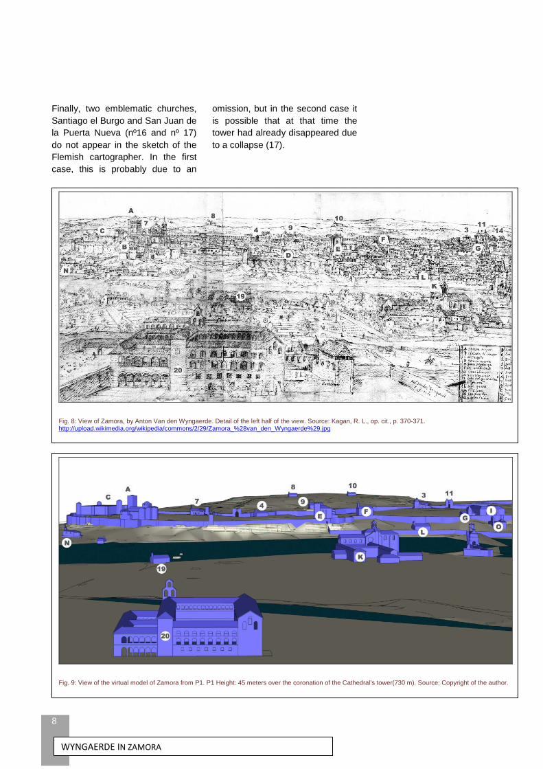
Finally, two emblematic churches, Santiago el Burgo and San Juan de la Puerta Nueva (nº16 and nº 17) do not appear in the sketch of the Flemish cartographer. In the first case, this is probably due to an
omission, but in the second case it is possible that at that time the tower had already disappeared due to a collapse (17).
Fig. 8: View of Zamora, by Anton Van den Wyngaerde. Detail of the left half of the view. Source: Kagan, R. L., op. cit., p. 370-371. http://upload.wikimedia.org/wikipedia/commons/2/29/Zamora_%28van_den_Wyngaerde%29.jpg
Fig. 9: View of the virtual model of Zamora from P1. P1 Height: 45 meters over the coronation of the Cathedral’s tower(730 m). Source: Copyright of the author.

WYNGAERDE IN ZAMORA
9
CONCLUSIONS
Wyngaerde’s initial intention when tackling the View of Zamora (and, by extension, all other views) was, without question, to be rigourously faithful to what he was seeing with his eyes.
However, when this principle came into conflict with the clear representation of all the elements, the Flemish cartographer did not hesitate in taking all kinds of liberties.
In the case of Zamora, the most notorious was the duplication of the perspectives for the reasons given above. This decision led him to draw the right half of the panoramic view from a perspective different from the main one.
Fig. 10: View of Zamora, by Anton Van den Wyngaerde. Detail or the right half of the view. Source: Kagan, R. L., op. cit., p. 371-372.
Fig. 11: View of the virtual model of Zamora from P2. P1 Height: 45 meters over the coronation of the Cathedral’s tower(730 m). Source: Copyright of the author.

WYNGAERDE IN ZAMORA
10
BIBLIOGRAPHIC NOTES
1. Kagan, Richard L. (dir.). 1986. Ciudades del siglo de Oro. Las vistas españolas de Anton Van den Wyngaerde. Madrid: El Viso. ISBN 84-86022-24-X
2. Sánchez del Barrio, Antonio . 1991. La estructura urbana de Medina del Campo. Valladolid: Junta de Castilla y León. P. 84 y ss. ISBN 84-7846-075-6
3. Rodríguez Méndez, Francisco Javier . 1998. “Localización de la puerta de Balborraz y otras aportaciones al conocimiento de las murallas de Zamora”. Anuario 1996 del Instituto de Estudios Zamoranos “Florián De Ocampo”. P. 349-387. ISSN 0213-82-12
4. Rodríguez Méndez, Francisco Javier . 2006. “Plan Director de las murallas de Zamora. Algunas aportaciones al conocimiento del Monumento”. En Actas del IV Congreso Internacional “Restaurar la Memoria”. Valladolid: Junta de Castilla y León. P. 557-570. ISBN 84-9718-360-6
5. Kagan, R. L ., op. cit., p. 10.
6. “Antonio de las Viñas nro pintor va por nra orden y mandado a pintar la descripción de algunos de essos pueblos principales... y hazer otras cossas de nro servicio tocantes al dho. Su officio queremos q en lo q por allá se le offreciere sea bien tratado... le dexeis y consintáis estar y residir libremente con sus criados y cabalgaduras y gente q le ha de ayudar". Taken from Haverkamp-Begemann, Egbert . 1991. “Las Vistas de España de Anton Van den Wyngaerde”. En Kagan, R. L., op. cit., p. 58.
7. Unfourtunately, the current whereabouts of the volume corresponding to 1570 from the minutes book of the City Council is unknown (Pescador del Hoyo, Mª del Carmen . 1948. Documentos históricos. Archivo Municipal de Zamora. Zamora: Heraldo de Zamora. P. 174).
8. Arévalo, Federico . 2003. La representación de la ciudad en el Renacimiento. Barcelona: Fundación Caja de Arquitectos. P. 127. ISBN 84-932542-6-6
9. Espejo, Cristóbal. 1908. “Modo de medir un término en tiempos de Felipe II”. Boletín de la Sociedad Castellana de Excursiones. Año VI, no. 61. P. 314-316. Taken from: Sánchez del Barrio, A, op. cit., p. 89, nota 137.
10. Arévalo, F. , op. cit., p. 199 y p. 203.
11. Sánchez del Barrio, A ., op. cit., p. 100.
12. Cuesta Aguilar, María José y Moya García, Egidio . 2011. “Una mirada a la imagen urbana de Jaén en el siglo XVI”. Exedra. Nº 5. P. 103-116.
13. Haverkamp-Begemann, E. , op. cit., p. 61.
14. Cermeño, J. M. 1766. Proyecto de fortificación de Zamora. Cartoteca Histórica del Servicio Geográfico del Ejército, Sección de Documentación, nº 339.
15. Sánchez del Barrio, A ., op. cit., p. 96.
16. Kagan, R. L ., op. cit., p. 205-207.
17. Ramos de Castro, Guadalupe . 1977. El Arte Románico en la provincia de Zamora. Zamora: Diputación Provincial. P. 177.