
Elletra’s presentation : December 2003 A quick presentation of TANGO.
Upload
adbwaterforallCategory
view
219download
0
8/6/2019 SVannareth Presentation
http://slidepdf.com/reader/full/svannareth-presentation 1/39
The views expressed in this paper/presentation are the views of the author and do not necessarily reflect the views or
policies of the Asian Development Bank (ADB), or its Board of Governors, or the governments they represent. ADBdoes not guarantee the accuracy of the data included in this paper and accepts no responsibility for any consequence oftheir use. Terminology used may not necessarily be consistent with ADB official terms.

8/6/2019 SVannareth Presentation
http://slidepdf.com/reader/full/svannareth-presentation 2/39
Water and Climate Change AdaptationWater and Climate Change AdaptationSelan or, Mala sia, December 1Selan or, Mala sia, December 1- -5, 200 5, 200 Water and Climate Change AdaptationWater and Climate Change AdaptationSelan or, Mala sia, December 1Selan or, Mala sia, December 1- -5, 200 5, 200
Vannareth SETHVannareth SETH
Ministry of Water Resources and MeteorologyMinistry of Water Resources and Meteorology
Email : [email protected]
Email : [email protected]
DOM / MOWRAM
8/6/2019 SVannareth Presentation
http://slidepdf.com/reader/full/svannareth-presentation 3/39
Case stud of Water and Climate inCase stud of Water and Climate inCase stud of Water and Climate inCase stud of Water and Climate inCambodiaCambodia
- -
CambodiaCambodia- - , ,, , ,,, ,, , ,,
DOM / MOWRAM
8/6/2019 SVannareth Presentation
http://slidepdf.com/reader/full/svannareth-presentation 4/39
• Introduction
• Organizations• Main Activities
• Main Constrains
• Strategic Plans
• Propose collaborations with NHRIM
DOM / MOWRAM

8/6/2019 SVannareth Presentation
http://slidepdf.com/reader/full/svannareth-presentation 5/39
• Introduction
• Organizations• Main Activities
• Main Constrains
• Strategic Plans
• Propose collaborations with NHRIM
DOM / MOWRAM

8/6/2019 SVannareth Presentation
http://slidepdf.com/reader/full/svannareth-presentation 6/39
Introduction
Cambodia is developing fast and meteorolo-gical data becomes more and more importantfor many sectors of Cambodia.
Weather and Climate seem to be morechanging and is becoming more unpredictablemaking it more and more difficult to rely on any
year to be normal.
One year flooding, next year drought andsome years you will may have flooding in one
area and later drought in another area.
MOWRAM
8/6/2019 SVannareth Presentation
http://slidepdf.com/reader/full/svannareth-presentation 7/39
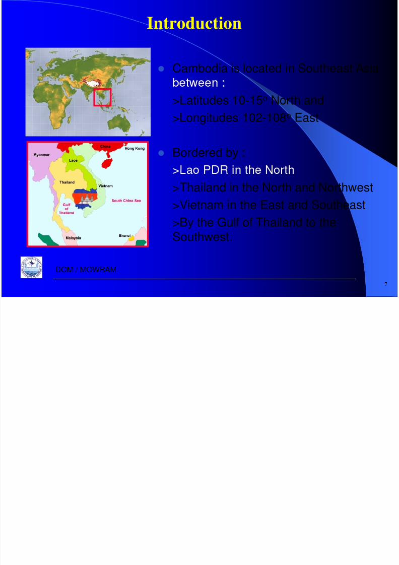
Introduction
Cambodia is located in Southeast Asia
>Latitudes 10-15o
North and>Longitudes 102-108o East
Bordered by : >Thailand in the North and Northwest
>Vietnam in the East and Southeast>By the Gulf of Thailand to theSouthwest.
7
DOM / MOWRAM
8/6/2019 SVannareth Presentation
http://slidepdf.com/reader/full/svannareth-presentation 8/39
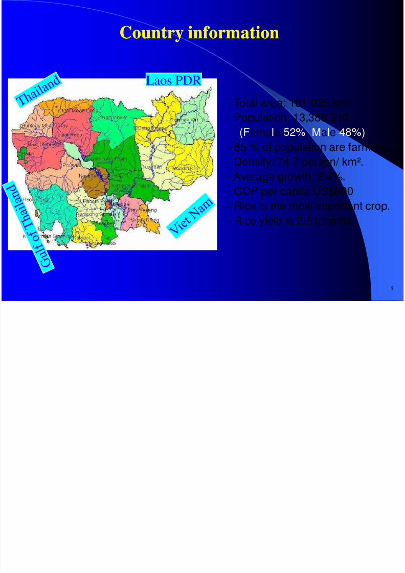
Country informationCountry information
Laos PDR
- Total area: 181,035 km²- Population: 13,388,910ema e , a e
- 85 % of population are farmers.
- Density: 74.7 person/ km².- Average growth: 2.4%.- GDP per capita US$600
- Rice is the most important crop.- Rice yield is 2.8 tons/ha.
8
8/6/2019 SVannareth Presentation
http://slidepdf.com/reader/full/svannareth-presentation 9/39
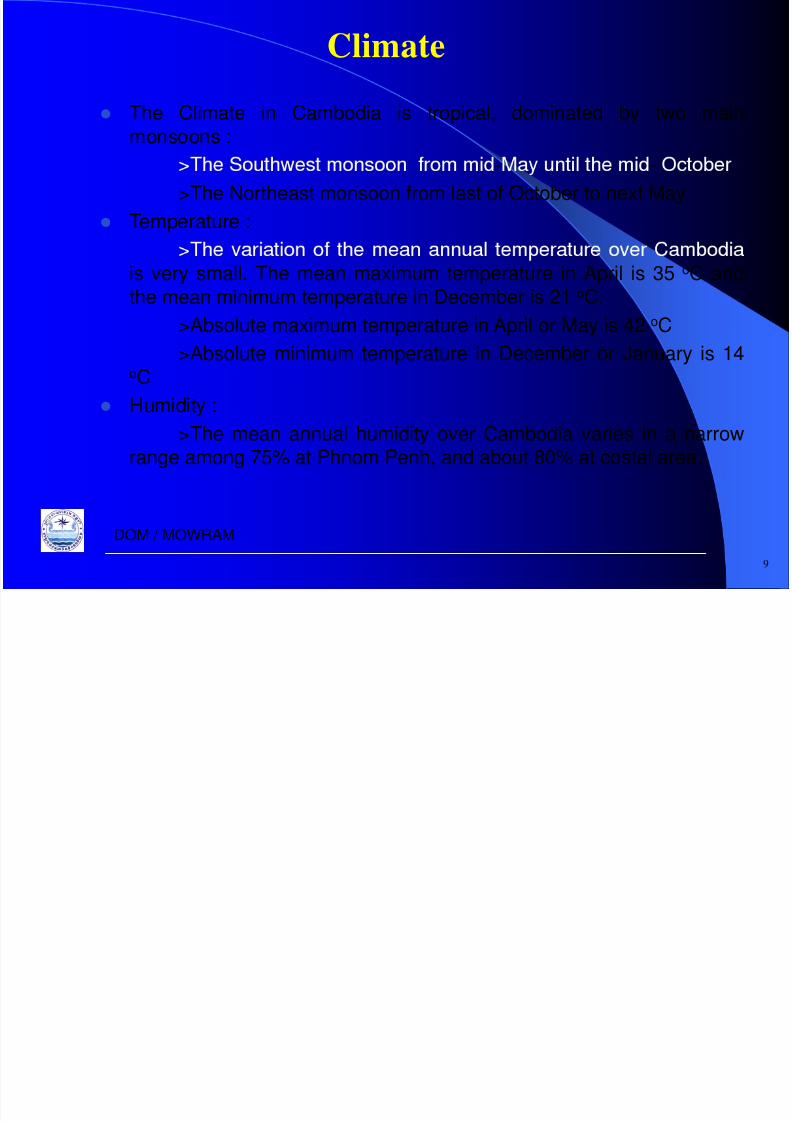
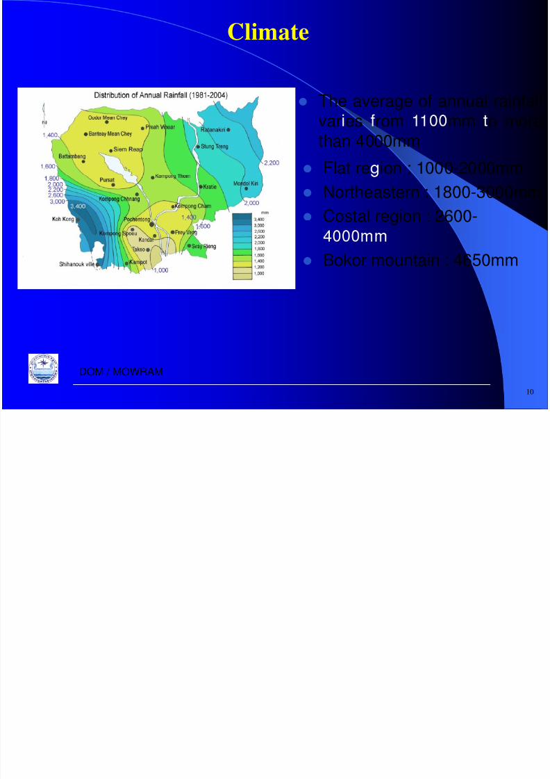
Climate
The Climate in Cambodia is tropical, dominated by two mainmonsoons :
- ->The Northeast monsoon from last of October to next May
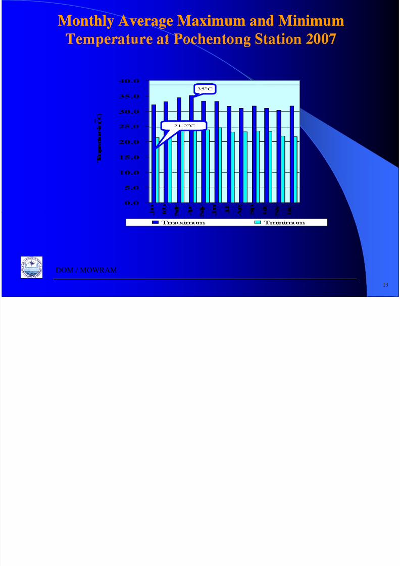
Temperature :
is very small. The mean maximum temperature in April is 35 oC andthe mean minimum temperature in December is 21 oC.
>Absolute maximum temperature in April or May is 42 oC>Absolute minimum temperature in December or January is 14
oC
Humidity :>The mean annual humidity over Cambodia varies in a narrowrange among 75% at Phnom Penh, and about 80% at costal area.
9
DOM / MOWRAM
8/6/2019 SVannareth Presentation
http://slidepdf.com/reader/full/svannareth-presentation 10/39
8/6/2019 SVannareth Presentation
http://slidepdf.com/reader/full/svannareth-presentation 11/39
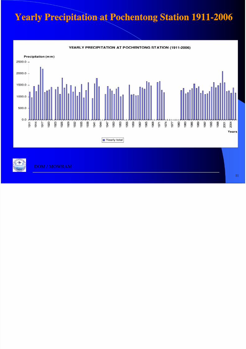
Yearly Precipitation at Pochentong Station 1911-2006Yearly Precipitation at Pochentong Station 1911-2006
YEARLY PRECIPITATION AT POCHENTONG STATION (1911-2006)
2000.0
2500.0
Precipitation (mm)
1000.0
1500.0
0.0
500.0
1 9 1 1
1 9 1 4
1 9 1 7
1 9 2 0
1 9 2 3
1 9 2 6
1 9 2 9
1 9 3 2
1 9 3 5
1 9 3 8
1 9 4 1
1 9 4 4
1 9 4 7
1 9 5 0
1 9 5 3
1 9 5 6
1 9 5 9
1 9 6 2
1 9 6 5
1 9 6 8
1 9 7 1
1 9 7 4
1 9 7 7
1 9 8 0
1 9 8 3
1 9 8 6
1 9 8 9
1 9 9 2
1 9 9 5
1 9 9 8
2 0 0 1
2 0 0 4
ears
Yearly total
11
DOM / MOWRAM

8/6/2019 SVannareth Presentation
http://slidepdf.com/reader/full/svannareth-presentation 12/39
Monthly Average Precipitation at Pochentong Station
-
Monthly Average Precipitation at Pochentong Station
-
MEAN MONTHLY PRECIPITATION AT POCHENTONG STATION (1911-2006)
250.0
300.0
150.0
200.0
r e c i p i t
a t i o n ( m m )
50.0
100.0 P
0.0
Jan Feb. Mar. Apr. May Jun. Jul. Aug. Sep. Oct. Nov. Dec.
MonthsMEAN
12
DOM / MOWRAM
8/6/2019 SVannareth Presentation
http://slidepdf.com/reader/full/svannareth-presentation 13/39

8/6/2019 SVannareth Presentation
http://slidepdf.com/reader/full/svannareth-presentation 14/39

8/6/2019 SVannareth Presentation
http://slidepdf.com/reader/full/svannareth-presentation 15/39
Flooding Issues
Bridge on the National Road 6A was
collapsed by year 2001 Mekong River
Collapse of embankment of national road
No 1 by overland flow from right bankFlood, in Kompong Cham Provinceside of Mekong river during the flood in
year 2000
15
DOM / MOWRAM
8/6/2019 SVannareth Presentation
http://slidepdf.com/reader/full/svannareth-presentation 16/39
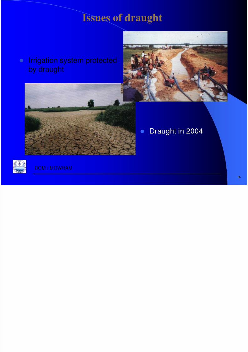
Issues of draught
Irrigation system protectedby draught
16
DOM / MOWRAM

8/6/2019 SVannareth Presentation
http://slidepdf.com/reader/full/svannareth-presentation 17/39

8/6/2019 SVannareth Presentation
http://slidepdf.com/reader/full/svannareth-presentation 18/39
ORGANIZATION STRUCTURE OF MOWRAMORGANIZATION STRUCTURE OF MOWRAM
MINISTERAND
SECRETARIES OF STATE
Cabinet of the MinisterUNDER SECRETARIES OF STATE
Directorate General of Inspection Department of Audit
Affaires
Department of Administration and
Human Resource Development
Directorate General of Technical Affaires
Department of Water Resource Management and
Conservation
Department of Planning and
International Cooperation
Department of Finance
Department of Hydrology and River Works
Department of Irrigated Agriculture
Department of Engineering
Department of Water Supply
Department of Meteorology
Technical Service Center for
Irrigation Meteorology
18Provincial and Municipality Bureaus of Water Resources and Meteorology
Department of Farmers Water User Community

8/6/2019 SVannareth Presentation
http://slidepdf.com/reader/full/svannareth-presentation 19/39
Structure of Department of Meteorology
Dept. of Meteorology
Ad. Office Obser. Office Equi. Office Fore. Office Clim. Office
Ad. Section
Plan. Section
Ob. Section
Agro. Section
Inst. Section
Rep.. Section
Weath. Section
Trop. Section
Gat. Section
Inf. Section
ResearchAvia.Meteo.
Section
Hydro-Meteorological Office
(Provincial Station)
DOM / MOWRAM

8/6/2019 SVannareth Presentation
http://slidepdf.com/reader/full/svannareth-presentation 20/39
Water Resource Potential in CambodiaWater Resource Potential in Cambodia
e err ng o e prev ous s u y, e prom s ng o a erResources Project has a potential as follows:
Water Resource Power in MW Irrigated rea
in ha Main Stream 10,800 734,000
Mekong Tributaries 2,727 253,000
Mekong Flooded Area - 179,000
Tonle Sa Tributaries 306 358 900
Outside Mekong Basin 1,146 142,000
Total 14,979 1,667,300
The total potential of water resource in Cambodia isestimated with minimizing risk of environmental problem, at
20
, .DOM / MOWRAM
8/6/2019 SVannareth Presentation
http://slidepdf.com/reader/full/svannareth-presentation 21/39
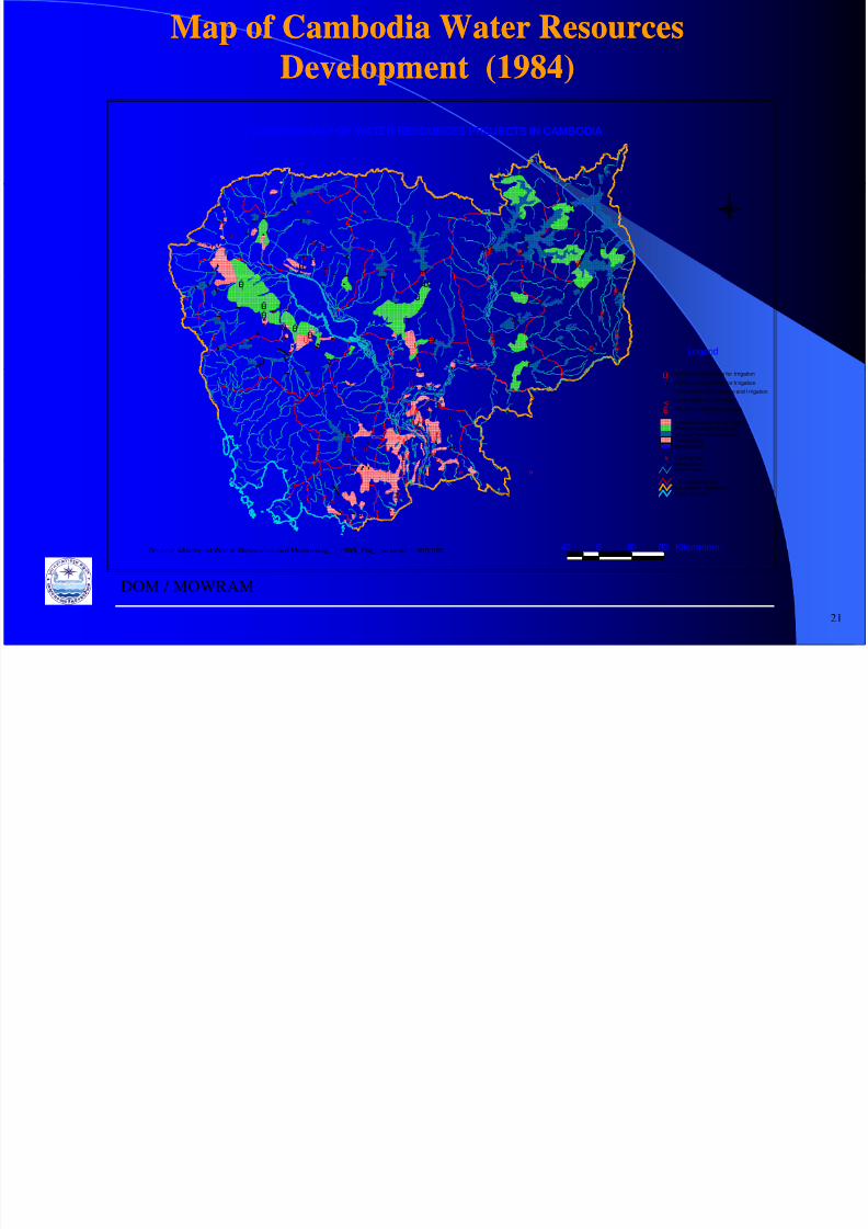
Map of Cambodia Water Resources
Development (1984)
Map of Cambodia Water Resources
Development (1984)
ÑÑ
LOCATION MAP OF WATER RESOURCES PROJECTS IN CAMBODIA
Ñ
Ñ ÑÑ
Ñ Ñ Ñ
Ñ ÑÑ Ñ
Ñ
Ñ Ñ
Ñ Ñ
ÑÑ
Ñ Ñ Ñ
Ñ Ñ
Ñ Ñ Ñ
Ñ Ñ
ÑÑ
Ñ
Ñ Ñ
Ñ Ñ Ñ
Ñ Ñ Ñ Ñ
Ë
ÊÚË
ËÚË Ë
Ú
Ë
N
Ñ
Ñ Ñ
Ñ Ñ Ñ
Ñ Ñ
Ñ Ñ
Ñ Ñ
ÑÑ Ñ Ñ Ñ
Ñ Ñ
ÑÑ
Ñ
Ñ Ñ ÑÑ
Ñ
Ñ Ñ Ñ
Ñ Ñ
Ñ Ñ
Ñ Ñ Ñ
Ñ
Ñ Ñ
ÑÑ
Ñ ÑÑ Ñ Ñ
ÊÚ
Ë
Ë
ÊÚÊÚ;
;
ÊÚ
Ú
ÊÚ; ;
;
ÊÚ
ÊÚ
ÊÚ
ÊÚ
ÊÚ
ËÚ
Ë
Ë
Ë
ËË
ËÚ
ÊÚ
;
Legend
Ñ ÑÑ
ÑÑ
Ñ
Ñ
Ñ
Ñ
Ñ
ÑÑ Ñ
Ñ ÑÑ Ñ Ñ
Ñ
Ñ Ñ Ñ Ñ Ñ
Ë
Ë
Ú
<Ú
Ú Ú
ÚÚ
ÚÚÚ
Ú
Ñ
Existing Dam
Irrigated Surfaces (until 1990)Potential Irrigated SurfacesExisting/Planned R eservoirsExisting DamPlanned Dam
Ú Existing Pump Station for Irrigation
ÊÚ Planned Pump St ation for Ir rigation
; Pump Station for Drainage and I rrigation
< Pump Station for Drainage
Ë Planned Hydroelectric Station
Ñ Ñ Ñ ÑÑ Ñ Ñ Ñ
Ñ Ñ Ñ Ñ
ÑÑ
Ñ ÑÑ Ñ Ñ
Ñ
Ë;
; ;; Provincial B oundaryInternational BoundaryGreat Lake/Sea
River/StreamÑ Planned Dam
40 0 40 80 KilometersSource: Ministr of Water Resources and Meteorolo , 1995 Ori inal scale 1:500,000
21
DOM / MOWRAM
8/6/2019 SVannareth Presentation
http://slidepdf.com/reader/full/svannareth-presentation 22/39
• Introduction
• Organizations• Main Activities
• Main Constrains
• Strategic Plans
• Propose collaborations with NHRIM
DOM / MOWRAM

8/6/2019 SVannareth Presentation
http://slidepdf.com/reader/full/svannareth-presentation 23/39
Main activities of the MOWRAMMain activities of the MOWRAM
Formulation of water resources development andManagement policy
Study and research on meteorology, hydrology, erosion
and morphology. Investigation on possible water resources, surface and
ground water, development including multipurpose dam,irrigation, drainage, water supply and river works.
Plan formulation of water resources development andre a tat on pro ects.
Design, implementation of Irrigation rehabilitation anddevelopment projects.
Operation, maintenance and administration of theseprojects
23
DOM / MOWRAM
8/6/2019 SVannareth Presentation
http://slidepdf.com/reader/full/svannareth-presentation 24/39
Main Activities of Department of Meteorology
• To Prepare the plan for rehabilitation and
and seismic throughout the country.
• To establish and manage the meteorological,.
• To observe the weather conduction for the
purpose to serve for all concerning sectors.• To forecast for the need of various
organizations and inform in advance the
n r l i r.• Provide consulting services on meteorology, ocean-
ographic and seismic.
DOM / MOWRAM
8/6/2019 SVannareth Presentation
http://slidepdf.com/reader/full/svannareth-presentation 25/39
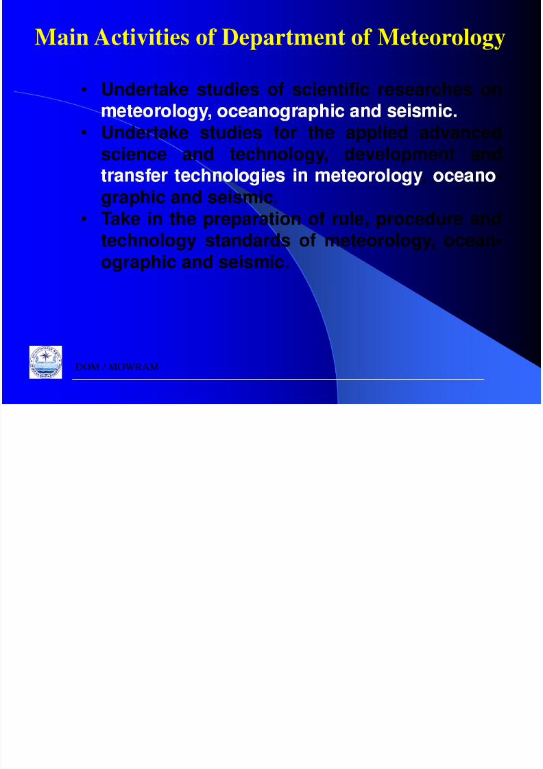
Main Activities of Department of Meteorology
• Undertake studies of scientific researches on
• Undertake studies for the applied advancedscience and technology, development and
, -graphic and seismic.
• Take in the preparation of rule, procedure andtechnology standards of meteorology, ocean-ographic and seismic.
DOM / MOWRAM
M t l i l A ti iti

8/6/2019 SVannareth Presentation
http://slidepdf.com/reader/full/svannareth-presentation 26/39
Siem Reap Kompong Thom Stung TrengPursat
Meteorological ActivitiesObservations, Data Collection, Forecasting, Study & Research, Planning
Manual Station
Kroties
Manual Station
Rattanakiri
Manual Station
Preah Vihear
Proposed Station
Kompong Chnang
N
EW
S
Map of Meteorology Station in Cambodia
#³
#³#³
³
#³
b
b
Manual Station
Banteay Meanchey
Battambang
DOM - Headquarter
#³
#³
#³
#³ #³
#³
#³
#
#³
b
c
bd
b
Manual Station
Koh Kong
Manual Station
Mondul-kiri
Legend
River#³ Provincial Center
Provincial BoundaryInternational BoundarySea/Lake
Meteorological Station
b Manual Recorder
c Automatic Recorder
d Manual and Automatic Recorder
#³
#³#³
#³#³
#³
#³
#³
#³
b
db
b
Proposed StationKandal
#³
#³ 20 0 20 40 Kilometers
Manual Station
Kompong Cham
Kompong Som(Sihanuok Ville)
Manual Station
Takeo
Proposed Station
Kompong Spoeu
Kampot Svay Rieng•Public Organization
(Royal Palace, Cabinet,Prim-Minister,Ministries., etc.)
26
Manual Station
Prey Veng
•TV & Radio Stations
•News Paper & etc.DOM / MOWRAM

8/6/2019 SVannareth Presentation
http://slidepdf.com/reader/full/svannareth-presentation 27/39

8/6/2019 SVannareth Presentation
http://slidepdf.com/reader/full/svannareth-presentation 28/39

8/6/2019 SVannareth Presentation
http://slidepdf.com/reader/full/svannareth-presentation 29/39

8/6/2019 SVannareth Presentation
http://slidepdf.com/reader/full/svannareth-presentation 30/39
Main constraints to Observe on Climate inMain constraints to Observe on Climate in
• No funding for climate change adaptation.• Lack of people involvement for climate change
adaptation.
DOM / MOWRAM
8/6/2019 SVannareth Presentation
http://slidepdf.com/reader/full/svannareth-presentation 31/39
• Introduction
• Organizations• Main Activities
• Main Constrains
• Strategic Plans
• Propose collaborations with NHRIM
DOM / MOWRAM

8/6/2019 SVannareth Presentation
http://slidepdf.com/reader/full/svannareth-presentation 32/39
Strategic Water Resources Development PlanStrategic Water Resources Development Plan
n e man a e othe Royal Government of Cambodian e man a e othe Royal Government of Cambodia
. The Ministry of Water Resources and Meteorology has a
800,000 ha (2008-2013);
. Annual develo ed and ex anded area is 160,000 ha;
. Annual budget required is 160 Million US$.
32
DOM / MOWRAM
8/6/2019 SVannareth Presentation
http://slidepdf.com/reader/full/svannareth-presentation 33/39
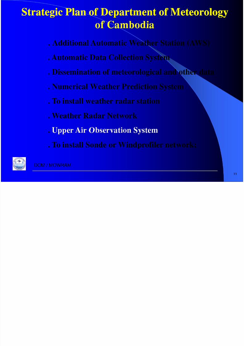
Strategic Plan of Department of MeteorologyStrategic Plan of Department of Meteorology
. Additional Automatic Weather Station (AWS)
. Automatic Data Collection System
. Dissemination of meteorological and other data
. Numerical Weather Prediction System
. To install weather radar station
. Weather Radar Network
.
. To install Sonde or Windprofiler network;
33
DOM / MOWRAM

8/6/2019 SVannareth Presentation
http://slidepdf.com/reader/full/svannareth-presentation 34/39
• Introduction
• Organizations• Main Activities
• Main Constrains
• Strategic Plans
• Propose collaborations with NHRIM
DOM / MOWRAM

8/6/2019 SVannareth Presentation
http://slidepdf.com/reader/full/svannareth-presentation 35/39
Ongoing Program and Projects inOngoing Program and Projects inOngoing Program and Projects inOngoing Program and Projects in
.
. Batheay Flood Control Project;
. Water Resources Master Plan Study;
. Feasibility of Battambang Multipurpose Project;
. Kraing Ponley Water Resources Development Project.
35
DOM / MOWRAM

8/6/2019 SVannareth Presentation
http://slidepdf.com/reader/full/svannareth-presentation 36/39
On oin Pro ram and Pro ect in De artmentOn oin Pro ram and Pro ect in De artment
of Meteorologyof Meteorology
. The Department of Meteorology has establishing the 21
. To develop the Forecast Model in the Costal Area;
. To Develop the Numerical Weather Prediction productor am o a m reso u on .
. Agricultural Research: drought resistant crops.
36
DOM / MOWRAM

8/6/2019 SVannareth Presentation
http://slidepdf.com/reader/full/svannareth-presentation 37/39
• Introduction
• Organizations• Main Activities
• Main Constrains
• Strategic Plans
• Propose collaborations with NHRIM
DOM / MOWRAM
8/6/2019 SVannareth Presentation
http://slidepdf.com/reader/full/svannareth-presentation 38/39
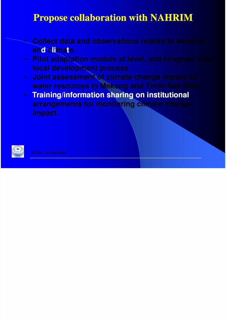
Propose collaboration with NAHRIMPropose collaboration with NAHRIM
• Collect data and observations related to weatheran c ma e.
• Pilot adaptation models at level, and integrate withlocal development process.
• Joint assessment of climate change impact on
water resources in Mekong and Tonle Sap River.• arrangements for monitoring climate changeimpact.
DOM / MOWRAM

8/6/2019 SVannareth Presentation
http://slidepdf.com/reader/full/svannareth-presentation 39/39
attentionattention
attentionattention
DOM / MOWRAM


![Presentation Guideline and Slide Gallery 16:9 · Presentation Guideline and Slide Gallery 16:9 Author [GfK Employee] Subject [Subtitle of presentation] Keywords: examples; presentation;](https://static.fdocuments.es/doc/165x107/5ffa01e2a5ee5b09787fbf25/presentation-guideline-and-slide-gallery-169-presentation-guideline-and-slide-gallery.jpg)