CHARCAS EN EL MAPA “AMÉRICA MERIDIONAL” … · quien dio por límites de jurisdicción a la...
26
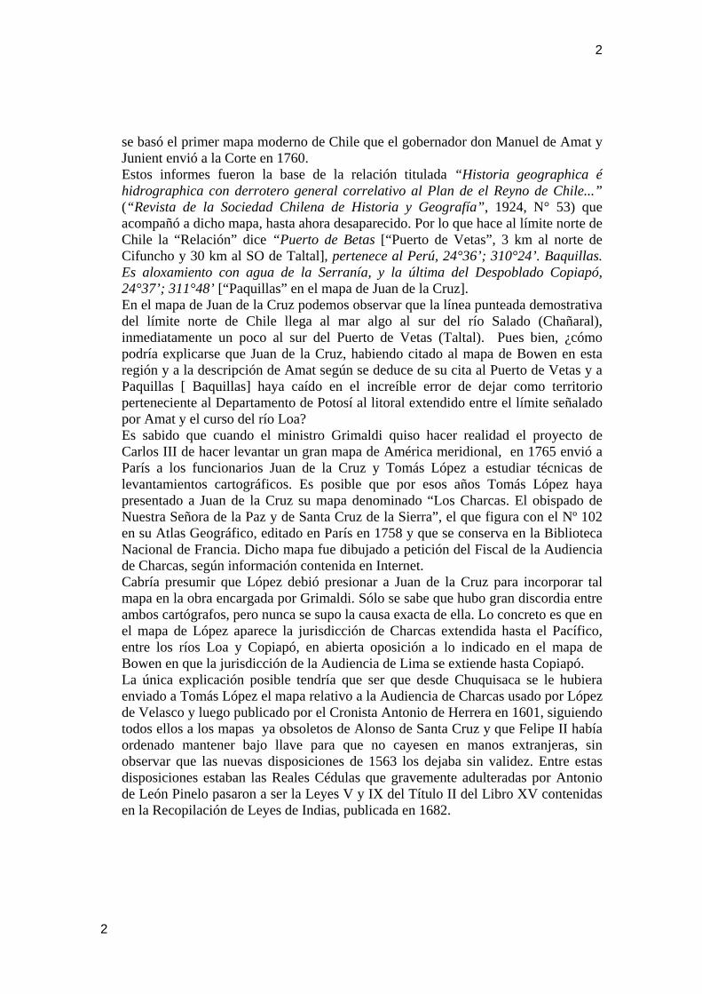
1 CHARCAS EN EL MAPA “AMÉRICA MERIDIONAL” GRABADO EN MADRID EN 1775 POR JUAN DE LA CRUZ Y CANO DE OLMEDILLA Félix Gajardo-Maldonado Sociedad Chilena de Historia y Geografía Londres Nº 65, Santiago, Chile, [email protected] Síntesis. Estudio crítico de una parte de un importante mapa. Su objetivo específico es valorizar la Cartografía como fuente auxiliar de la Historia mediante el análisis jurídico de los antecedentes históricos que le dieron origen. El resultado de este estudio explica la gran desorientación que produjo en las autoridades locales el gran mapa “América Meridional”. Como conclusión puede afirmarse que “la verdad tarda, pero llega” y sin ella no hay reconciliación posible entre países vecinos. EL LITORAL DEL DESPOBLADO DE ATACAMA NUNCA PERTENECIÓ AL VIRREINATO DEL RÍO DE LA PLATA Durante el gobierno del Virrey del Perú Andrés Hurtado de Mendoza, Marqués de Cañete, el oidor de la Audiencia de Lima Lic. Altamirano creó por su propia iniciativa un cargo de Protector de los Indígenas residentes en el valle del río Loa mediante carta de fecha 18 de enero de 1557 dirigida al cacique Juan. Este cargo fue servido por Juan Velásquez Altamirano, residente en Potosí, cuyos emolumentos serían pagados con fondos de aquel distrito (Colección de documentos inéditos del Archivo de Indias, 1864). Molesto Felipe II destituyó al Virrey y envió en su reemplazo al Conde de Nieva quien dio por límites de jurisdicción a la recién creada Audiencia de Charcas un círculo de cien leguas con centro en la Ciudad de La Plata, la antigua Chuquisaca y hoy Sucre, el que cortaba el litoral por el norte en el río Tambopalla y por el sur ligeramente al norte de Cobija. Enseguida nos preocuparemos del importantísimo mapa de “América Meridional” grabado entre 1765 y 1775 por Juan de la Cruz y Cano de Olmedilla, siguiendo instrucciones precisas del Ministro Grimaldi bajo el reinado de Carlos III, en el sentido de atenerse a los últimos y mejores mapas que pudiera conseguir. Entre los mapas usados por Juan de la Cruz figura “A New and Accurate Map of Peru and the Country of the Amazones, drawn from the most authentic French Maps and Regulated by Astronomical Observations by Emmanuel Bowen”, circa 1750, citado por de la Cruz al referirse a San Pedro de Atacama. Esta carta figura entre los mapas históricos del Perú publicados en Wikipedia. En el mapa de Bowen, inmediatamente al sur del Perú figura la expresión “Part of Chili”. El límite entre ambos países aparece con línea en colores verde y amarillo, siguiendo el curso del río Salado, al norte del lugar denominado Juncal. Encontramos una estupenda coincidencia entre el límite norte de Chile indicado en el mapa “América Meridional” y los informes que los corregidores entregaron a don José Perfecto Salas, por entonces Fiscal de la Audiencia de Santiago, y en los cuales 1
Transcript of CHARCAS EN EL MAPA “AMÉRICA MERIDIONAL” … · quien dio por límites de jurisdicción a la...
1
CHARCAS EN EL MAPA “AMÉRICA MERIDIONAL” GRABADO EN MADRID EN 1775 POR JUAN DE LA CRUZ Y
CANO DE OLMEDILLA
Félix Gajardo-Maldonado Sociedad Chilena de Historia y Geografía
Londres Nº 65, Santiago, Chile, [email protected] Síntesis. Estudio crítico de una parte de un importante mapa. Su objetivo específico es valorizar la Cartografía como fuente auxiliar de la Historia mediante el análisis jurídico de los antecedentes históricos que le dieron origen. El resultado de este estudio explica la gran desorientación que produjo en las autoridades locales el gran mapa “América Meridional”. Como conclusión puede afirmarse que “la verdad tarda, pero llega” y sin ella no hay reconciliación posible entre países vecinos. EL LITORAL DEL DESPOBLADO DE ATACAMA NUNCA PERTENECIÓ AL VIRREINATO DEL RÍO DE LA PLATA
Durante el gobierno del Virrey del Perú Andrés Hurtado de Mendoza, Marqués de Cañete, el oidor de la Audiencia de Lima Lic. Altamirano creó por su propia iniciativa un cargo de Protector de los Indígenas residentes en el valle del río Loa mediante carta de fecha 18 de enero de 1557 dirigida al cacique Juan. Este cargo fue servido por Juan Velásquez Altamirano, residente en Potosí, cuyos emolumentos serían pagados con fondos de aquel distrito (Colección de documentos inéditos del Archivo de Indias, 1864). Molesto Felipe II destituyó al Virrey y envió en su reemplazo al Conde de Nieva quien dio por límites de jurisdicción a la recién creada Audiencia de Charcas un círculo de cien leguas con centro en la Ciudad de La Plata, la antigua Chuquisaca y hoy Sucre, el que cortaba el litoral por el norte en el río Tambopalla y por el sur ligeramente al norte de Cobija. Enseguida nos preocuparemos del importantísimo mapa de “América Meridional” grabado entre 1765 y 1775 por Juan de la Cruz y Cano de Olmedilla, siguiendo instrucciones precisas del Ministro Grimaldi bajo el reinado de Carlos III, en el sentido de atenerse a los últimos y mejores mapas que pudiera conseguir. Entre los mapas usados por Juan de la Cruz figura “A New and Accurate Map of Peru and the Country of the Amazones, drawn from the most authentic French Maps and Regulated by Astronomical Observations by Emmanuel Bowen”, circa 1750, citado por de la Cruz al referirse a San Pedro de Atacama. Esta carta figura entre los mapas históricos del Perú publicados en Wikipedia. En el mapa de Bowen, inmediatamente al sur del Perú figura la expresión “Part of Chili”. El límite entre ambos países aparece con línea en colores verde y amarillo, siguiendo el curso del río Salado, al norte del lugar denominado Juncal. Encontramos una estupenda coincidencia entre el límite norte de Chile indicado en el mapa “América Meridional” y los informes que los corregidores entregaron a don José Perfecto Salas, por entonces Fiscal de la Audiencia de Santiago, y en los cuales
1
2
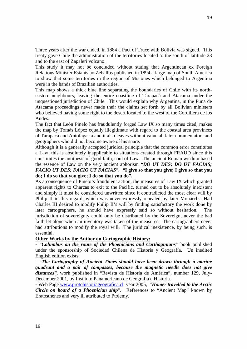
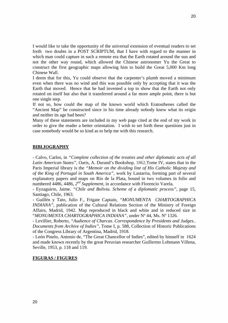
se basó el primer mapa moderno de Chile que el gobernador don Manuel de Amat y Junient envió a la Corte en 1760. Estos informes fueron la base de la relación titulada “Historia geographica é hidrographica con derrotero general correlativo al Plan de el Reyno de Chile...” (“Revista de la Sociedad Chilena de Historia y Geografía”, 1924, N° 53) que acompañó a dicho mapa, hasta ahora desaparecido. Por lo que hace al límite norte de Chile la “Relación” dice “Puerto de Betas [“Puerto de Vetas”, 3 km al norte de Cifuncho y 30 km al SO de Taltal], pertenece al Perú, 24°36’; 310°24’. Baquillas. Es aloxamiento con agua de la Serranía, y la última del Despoblado Copiapó, 24°37’; 311°48’ [“Paquillas” en el mapa de Juan de la Cruz]. En el mapa de Juan de la Cruz podemos observar que la línea punteada demostrativa del límite norte de Chile llega al mar algo al sur del río Salado (Chañaral), inmediatamente un poco al sur del Puerto de Vetas (Taltal). Pues bien, ¿cómo podría explicarse que Juan de la Cruz, habiendo citado al mapa de Bowen en esta región y a la descripción de Amat según se deduce de su cita al Puerto de Vetas y a Paquillas [ Baquillas] haya caído en el increíble error de dejar como territorio perteneciente al Departamento de Potosí al litoral extendido entre el límite señalado por Amat y el curso del río Loa? Es sabido que cuando el ministro Grimaldi quiso hacer realidad el proyecto de Carlos III de hacer levantar un gran mapa de América meridional, en 1765 envió a París a los funcionarios Juan de la Cruz y Tomás López a estudiar técnicas de levantamientos cartográficos. Es posible que por esos años Tomás López haya presentado a Juan de la Cruz su mapa denominado “Los Charcas. El obispado de Nuestra Señora de la Paz y de Santa Cruz de la Sierra”, el que figura con el Nº 102 en su Atlas Geográfico, editado en París en 1758 y que se conserva en la Biblioteca Nacional de Francia. Dicho mapa fue dibujado a petición del Fiscal de la Audiencia de Charcas, según información contenida en Internet. Cabría presumir que López debió presionar a Juan de la Cruz para incorporar tal mapa en la obra encargada por Grimaldi. Sólo se sabe que hubo gran discordia entre ambos cartógrafos, pero nunca se supo la causa exacta de ella. Lo concreto es que en el mapa de López aparece la jurisdicción de Charcas extendida hasta el Pacífico, entre los ríos Loa y Copiapó, en abierta oposición a lo indicado en el mapa de Bowen en que la jurisdicción de la Audiencia de Lima se extiende hasta Copiapó. La única explicación posible tendría que ser que desde Chuquisaca se le hubiera enviado a Tomás López el mapa relativo a la Audiencia de Charcas usado por López de Velasco y luego publicado por el Cronista Antonio de Herrera en 1601, siguiendo todos ellos a los mapas ya obsoletos de Alonso de Santa Cruz y que Felipe II había ordenado mantener bajo llave para que no cayesen en manos extranjeras, sin observar que las nuevas disposiciones de 1563 los dejaba sin validez. Entre estas disposiciones estaban las Reales Cédulas que gravemente adulteradas por Antonio de León Pinelo pasaron a ser la Leyes V y IX del Título II del Libro XV contenidas en la Recopilación de Leyes de Indias, publicada en 1682.
2
3
LA DISPOSICIÓN DE LA LEY IX DEL TÍTULO II DEL LIBRO XV DE LA RECOPILACIÓN DE LEÓN PINELO QUE DA UNA FALSA SALIDA DE CHARCAS AL PACÍFICO DEBE TENERSE POR NO ESCRITA PORQUE EL RECOPILADOR NUNCA TUVO AUTORIZACIÓN PARA AGREGAR TAL MODIFICACIÓN Ha poco de subir al trono español Felipe IV, nombró a Antonio de León Pinelo Juez de la Casa de la Contratación de Sevilla y Relator del Consejo de Indias a sugerencia de su Ministro el Conde Duque de Olivares. Hacia 1624 el Consejo encargó a León Pinelo recopilar y resumir la copiosísima legislación indiana, dados sus conocimientos y capacidad demostradas durante su anterior ejercicio profesional como Regidor de Oruro, Asesor del Corregidor de Potosí y Abogado de la Audiencia de los Reyes. Tras ímproba labor, según él mismo narró, logró reducir a poco más de 11 mil la imposible cantidad de 400 mil Reales Cédulas que dijo haber consultado. Tras esta cortina de humo, León Pinelo cayó en el imperdonable delito de lesa majestad al desvirtuar conscientemente el sentido de las disposiciones reales por medio del garlito de omitir una palabra fundamental. Veamos cómo lo hizo. La primera de las cuatro Reales Cédulas del 29 de agosto de 1563, aquella que reservó para la Audiencia de Lima toda la costa del Océano Pacífico desde Paita hasta el puerto de Copiapó, estaba correctamente vinculada con la segunda Real Cédula del mismo día 29 de agosto de 1563, aquella que amplió la jurisdicción de Charcas mediante la agregación a ésta de la jurisdicción del TUCUMÁN, PROVINCIA MEDITERRÁNEA CORRESPONDIENTE AL ALTIPLANO Y QUE, POR CONSIGUIENTE, NO PODÍA TENER SALIDA AL MAR. Textual: “…combiene que á la dicha Audiencia de los Charcas se le den más límites, y que éstos sean la governación de Tucumán y Juríes y Diaguitas…” (Levillier,1918 : 588). Su fraude queda de manifiesto porque al redactar inmediatamente después la que llegaría a ser la Ley IX de la Recopilación, omitió, dolosamente, el topónimo “Tucumán” que venía expresamente en la Real Cédula firmada por Felipe II. La omisión de que damos cuenta habría sido hecha por León Pinelo para hacer creer a quien sacare la Ley IX del contexto de las otras leyes, que Charcas habría adquirido derecho a salida al mar debido a su condición de heredera de la “Nueva Toledo” de Almagro. Tan bien hecho estuvo su subterfugio que hasta ahora había pasado inadvertido de todos los investigadores. Veamos cómo quedó el texto de lo que llegó a ser la Ley IX del Libro II, Título XV de la Recopilación en que la palabra TUCUMÁN no aparece en parte alguna: “En La Ciudad de la Plata de la Nueva Toledo [?], Provincia de los Charcas, en el Perú, resida otra nuestra Audiencia y Chancillería Real...., la qual tenga por distrito la Provincia de los Charcas, y todo el Collao,… con las Provincias de Sangabana, Carabaya, Iuríes y Diaguitas, Moyos y Chunchos, y Santa Cruz de la Sierra, partiendo términos: por el Septentrión con la Real Audiencia de Lima, y Provincias no descubiertas: por el Mediodía con la Real Audiencia de Chile: y por el Levante y Poniente con los dos mares del Norte y del Sur, y linea de la demarcación entre las Coronas de los Reynos de Castilla y de Portugal, por la parte de la Provincia de Santa Cruz del Brasil”.
3
4
Obsérvense las notas marginales a esta Ley, compulsadas por León Pinelo y que no vienen citadas en las reediciones posteriores: “D. Felipe Segundo y la princesa G. en Valladolid à 4 de Setiembre de 1559: En Guadalaxara à 29 de Agosto de 1563; Y a 1 de Octubre de 1566; Y en Madrid à 26 de Mayo de 1573; Y D. Felipe Quarto en esta Recopilación”. Adviértase un nuevo fraude de León Pinelo en sus notas marginales a la Ley IX al hacer parecer que el texto de la Ley IX sería consecuencia exclusiva de las Reales Cédulas verdaderamente aprobadas por Felipe II. Entre estas disposiciones no aparece ninguna referencia a la Nueva Toledo de Almagro ni menos que tuviese salida a ambos Océanos. ¡Esto último fue invento de León Pinelo! Veamos el texto de la Real Cédula del 26 de mayo de 1573 para comprender cabalmente la denuncia que estamos formulando: “Real Cédula dividiendo el distrito del Cuzco entre las Audiencias de los Reyes y Charcas. 26 de Mayo de 1573. EL REY DON PHELIPPE, &. = Por quanto en los límites y distrito que por Nos fué dado y adjudicado á la nuestra Audiencia Real que rreside en la ciudad de la Plata de los Charcas de las provincias del Perú, le huvimos señalado y nombrado entre otros á la ciudad del Cuzco y su término y jurisdicción; y, después, aviendo sido informado que hera más conveniente que la dicha ciudad del Cuzco estuviese subjeta á la nuestra Audiencia Real que rreside en la dicha ciudad de los Reyes de las dichas provincias, como primeramente lo avía estado, por nuestra Carta y Provisión Real firmada de mí mismo y librada por los del nuestro Consejo de las Indias, dada en Aranjuez á último de Noviembre [30 de noviembre] del año passado de quinientos y sesenta y ocho, proveymos y mandamos que la dicha ciudad del Cuzco y su término y jurisdición fuese y estuviese en el distrito de la dicha Audiencia de los Reyes; é, agora, siendo mejor informado de lo que á ello se deve probeer y es más conveniente y necesario á nuestro servicio y buena governación de aquella tierra, visto y platicado por los del dicho nuestro Consejo, havemos acordado y determinado de dividir y partir los términos y jurisdición de la dicha ciudad del Cuzco entre las dichas nuestras Audiencias de los Reyes y los Charcas. Por ende, por la presente declaramos y mandamos y es nuestra voluntad que todo lo que está desde el Collao, esclusibe, hazia la ciudad de los Reyes, quede y sea y esté devaxo del distrito y jurisdictión de la dicha nuestra Audiencia Real que rreside en la dicha ciudad de los Reyes; y todo lo que está desde el Collao, inclusive, hacia la dicha ciudad de la Plata, quede y buelva y sea del distrito y límites de la dicha nuestra Audiencia de los charcas; declarando como declaramos quel dicho Collao, hazia la dicha ciudad de la Plata, comience desde el pueblo de Ayabire, que es de la encomienda de Juan de Pancorbo por el camino de Urcosuyo; y desde el pueblo de Asillo que es de la encomienda de Gerónimo Costilla, por el camino de Omasuyo; y por el camino de Arequipa, desde Atuncana, que es de la encomienda de Don Carlos Ynga, hacia la parte de los Charcas. Y ansimismo, a de ser y entrar en el distrito de la dicha Audiencia de los Charcas, la provincia de Sangavana y toda la provincia de Carabaya, ynclusibe. Lo qual mandamos que ansí se guarde y cumpla, no embargante lo que por
4
5
la dicha Provissión, de que desuso se hace mención, esté por Nos proveydo y ordenado otra cossa en contrario; rrebocándolo, como lo rebocamos, y damos por de ningún valor y hefecto, en quanto á esto toca; no perjudicando, como queremos no perjudique, esta declaración y división que ansí hazemos, en cosa alguna, á la jurisdicción que la dicha ciudad del Cuzco tiene en los dichos términos; sino que la tenga según y de la manera que hasta aquy la a tenido. Y mandamos al nuestro Visorrey, Presidentes y Oydores de las dichas nuestras Audiencias de los Reyes y de los Charcas y á todos los vezinos y moradores estantes y abitantes en las dichas provincias del Perú, que guarden y cumplan esta nuestra Carta y lo en ello contenido; y contra su tenor y forma no bayan ni pasen en manera alguna. Y mandamos que sea publicada esta nuestra Provisión en los puntos y lugares que convenga, para que venga á noticia de todos. Dada en Madrid, á veynte y seis del mes de Mayo de mill y quinientos y setenta y tres años. YO EL REY. Refrendada de Francisco de Eraso y firmada del Presidente, Licenciado Don Juan de Obando; Licenciado Castro, Licenciado Don Gómez Çapata, Licenciado Otálora, Licenciado Gamboa. (Del Arch. de Ind.- Est. 109.- Caj. 7.- Leg. 14/26, según la Clasificación Antigua) (Maúrtua,1906 : 177). Tan claro entendió Charcas la segregación de la costa del Pacífico que había hecho el Rey en 1563 que de inmediato reclamó la imperiosa necesidad de mantener el puerto de Arica bajo su jurisdicción. A esto el Rey resolvió: “Que el correjidor de Arica, aunque sea del distrito de la audiencia de Lima, cumpla los mandamientos de la de los Charcas. Mandamos que sin embargo de que la ciudad i puerto de Arica sea i esté en el distrito de la real audiencia de los Reyes,…”. León Pinelo entendió perfectamente el alcance de dicha disposición y se sintió obligado a incorporarla bastante más adelante de modo que quedó como Ley XV de su proyecto de “Recopilación”. En su obra “El Gran Canciller de Indias”, León Pinelo alude a las delimitaciones de las jurisdicciones correspondientes a cada Cancillería. En lo relativo a la de Charcas dice: “§ VIII. Del Canciller i Registrador de La Chancilleria Real de La Plata. El sexto Canciller i Registrador es el de La Audiencia de La Plata; su despacho es por una sala Lo civil i criminal para su distrito, que comiença donde acaba el de La Audiencia de Lima, incluiendo La provincia del Collao por el camino de Urcosuyo desde el pueblo de Ayaviri; por el de Omasuyo desde el pueblo de Asillo; i por el de Arequipa desde Atumcana, con Las dos provincias de Sangavan i Carabaya, i sin Llegar a La costa de La mar del Sur, atraviesa desde Los confines de Arequipa a Las Cordilleras de Chile por Atacama, i apartándose Luego dellas, por dexar La provincia de Cuyo, va incluiendo i costeando Las Governaciones de Tucuman,Iuries i Dieguitas…” Como prueba irredargüible de la importancia de lo afirmado, podemos incluir el texto de la jurisdicción de la Cancillería de Chile, situada inmediatamente al sur de la Gran Cancillería del Perú:“§ VIII. Del Canciller i Registrador de La Chancillería Real de Chile. El séptimo Canciller es el de La Audiencia del Reyno de Chile. Su despacho es
5
6
por una sala para todo el Reyno, que se estiende por La costa desde Los confines de Tarapacá, que es de La Audiencia de Lima, hasta Chiloé, que es Lo ultimo que está poblado azia el Estrecho de Magallanes…” (León Pinelo, 1624). Desgraciadamente no hemos podido encontrar los originales de las Reales Cédulas que fijaron las jurisdicciones de estas Cancillerías. Las disposiciones de la Real Cédula del 26 de mayo de 1573 las hemos encontrado muy bien expresadas en una línea punteada representativa de la división del territorio del Collao que se observa en el ángulo superior izquierdo del mapa de Tomás López de 1758 ya citado, lo que quiere decir que esta Real Cédula era perfectamente conocida por los Oidores de la Real Audiencia de Chuquisaca. Sin embargo, en este mismo mapa, Tomás López incluyó en el territorio del Departamento de Potosí el litoral del Pacífico extendido entre la boca del Loa y un punto situado algo más al sur de Cobija, lo que demuestra que se atenía a las disposiciones de la Ley IX de la Recopilación de Leyes de los Reynos de Indias. Quizás si para disimular en alguna medida su falsificación de jurisdicciones, León Pinelo se guió por los mapas que había usado López de Velasco y publicado Antonio de Herrera en 1601, los que habían sido delineados por Alonso de Santa Cruz hacia 1563. GRAVÍSIMAS CONSECUENCIAS DEL MAPA AMÉRICA MERIDIONAL Por Real Cédula de 1° de septiembre de 1776 se creó el Virreinato del Río de la Plata que, a instancias del General Pedro de Cevallos, además de las Provincias aledañas al Río de la Plata, debía incluir toda la JURISDICCIÓN de la Audiencia de Charcas con el objeto de formar un ente económicamente poderoso, capaz de detener las incontenibles incursiones de los bandeirantes portugueses. Es incuestionable que el Virrey Pedro de Cevallos (1777 – 1778) no pudo tener interés alguno en el litoral del Pacífico, aunque en el mapa de Juan de la Cruz y Cano de Olmedilla éste aparecía como parte integrante de Charcas, porque del litoral desértico no podría obtener ni hombres ni rentas que le ayudaran a cumplir el único objetivo de su misión. Cobija solamente era importante por el contrabando ocasional que allí se ejercía y por esto no aportaba nada a la Corona. El Virrey del Perú Teodoro de Croix (1784 – 1790) tendría dudas respecto a la conveniencia de incorporar el litoral del despoblado de Atacama al naciente Virreinato del Río de la Plata. Refiriéndose a la defensa naval de su propio territorio, dijo que le sería difícil mantenerla “principalmente en los puertos y ensenadas de la dilatada costa confinante con las provincias adjudicadas al virreinato de Buenos Aires” (Eyzaguirre, 1963 : 15). Es decir, el Virrey de Croix creía que Chile debía continuar su vigilancia como lo venía haciendo desde los primeros tiempos. También cayó en contradicciones el Coronel D. Antonio de Alcedo, Capitán de Reales guardias españolas, quien en su “Diccionario Geográfico-histórico de las Indias Occidentales o América”, impreso en Madrid en 1786, escribió:“Charcas.- Provincia dilatada del reino del Perú, compuesta de otras varias; cuya jurisdiccion comprende el distrito de esta real audiencia, que empieza en Vilcanota del correjimiento de Lampa i obispado del Cuzco, i llega hasta Buenos Aires por la parte del sur: confina por el
6
7
Oriente con el Brasil, sirviéndole de términos el meridiano de demarcacion, i por el Occidente llega hasta el mar del Sur por el correjimíento de Atacama, que es de su distrito, i lo mas septentrional de ella por aquella parte, i en lo restante confina con el reino de Chile; tiene de largo 300 leguas desde 20 hasta 28 grados de latitud austral: en muchos parajes está poco poblada…”. Respecto al Perú dice:“Los límites de este reino han sido varios segun la diferencia de los Gobiernos: hoi se estiende a la jurisdiccion de las audiencias de Lima, Charcas i Chile,…se estiende hasta Tumbes en 3º25’ de latitud austral hasta el desierto de Atacama, que es el límite boreal del reino de Chile…”. Estas afirmaciones implican una evidente contradicción. El Virrey del Perú Francisco Gil de Taboada y Lemus (1790 – 1796) deseoso de satisfacer los requerimientos de la Corona en orden a contar con la mejor cartografía astronómica posible de obtener con los instrumentos de su tiempo, encomendó esta tarea a don Andrés de Baleato, Tte. graduado de la Academia Náutica de Lima. Éste, para un acabado cumplimiento del encargo, hizo su estudio apoyado en los más modernos mapas existentes. El “Plano General del Reyno de Chile.....que comprende desde 21 ½ [río Loa] hasta 47 grados de Latitud S....” fue terminado el año 1793. El topónimo “Desierto de Atacama” está escrito desde el sur del río Loa hasta la altura de “Bahia de N. Sra. [del Paposo]”. Sin embargo, el mapa del mismo autor titulado “Plano general del Reyno del Perú..........que comprende desde la Equinoccial hasta 26 ½ grados de Latitud S......” implica el deseo expreso de Baleato de no seguir en este punto al mapa de Juan de la Cruz y Cano de Olmedilla, por cuanto de los mapas del Perú y de Chile se colige que el Despoblado de Atacama pertenecía necesariamente o a Chile o a Perú, pero en ningún caso al Virreinato de Buenos Aires. Sin embargo, en su obra “Apuntes sobre las divisiones política y natural del virreinato del Perú”, de 1813, Baleato dice respecto a las Provincias del Alto Perú que “la Intendencia de Potosí incluye el Partido y Desierto de Atacama, cuyos surgidores [surgideros] de Cobija, Mexillones y Paposo en esta mar, están por distantes y extraviados en imposibilidad de atenderlo Buenos Aires” (Saavedra, 1906 : 306). Esta última afirmación se explicaría porque Baleato siguió al mapa “América Meridional” de Juan de la Cruz y Cano de Olmedilla casi al pie de la letra, pues en éste aparece el “Despoblado de Atacama” como integrante de la jurisdicción de la Audiencia de Charcas, según la errónea información proveniente del mapa de Tomás López. Baleato citó al mapa “de Cruz” en sus notas explicativas que acompañan al mapa de Chile. Para terminar la exposición cronológica de los principales mapas atingentes a la jurisdicción a que perteneció el “Despoblado de Atacama”, creemos de interés exhibir el mapa que figura en recuadro en el borde inferior derecho del planisferio iluminado titulado “MAPA GEOGRAFICO DE AMERICA MERIDIONAL, DE PARTE DE AFRICA Y DE ASIA.......Dispuesto Por D. Miguel de Lastarria y Delineado Por D. Francisco Fernández” (Guillén y Tato, 1942 : 44). El importantísimo mapa del recuadro aludido lleva el título “CARTA COROGRAFICA Del Virreynato de las Provincias del Río de la Plata” (Calvo, 1862). Lo más importante para la tesis que se ha venido demostrando en el desarrollo de esta investigación, radica en que si bien este mapa contiene casi los mismos elementos que el mapa de Joaquín
7
8
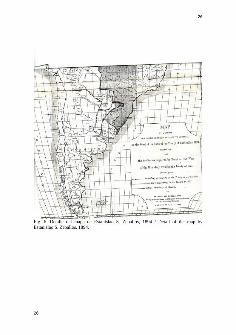
Alós, se diferencia substancialmente de él en que destaca con línea roja el límite sur del Perú sobre el río Loa. Mientras los territorios de las intendencias de Charcas están iluminados con los colores verde obscuro, verde claro y rosa pálido, los territorios del Virreinato del Perú y del “Despoblado de Atacama” están absolutamente en blanco, lo que demuestra palmariamente que los territorios al sur del Loa no pertenecían ni al Departamento de Lipes ni al Departamento de Potosí . El Lic. Miguel José de Lastarria debió estar íntimamente persuadido de que el “Despoblado de Atacama” no podría haber pertenecido a la Audiencia de Charcas porque nunca existió una disposición expresa del Monarca que atribuyese tal jurisdicción. Esta materia tuvo que conocerla muy a fondo por las preocupaciones que sobre este tema debió atender como secretario del Marqués de Avilés entre 1796 y 1801, durante el desempeño de éste primero como Gobernador de Chile y luego como Virrey del Río de la Plata. Los actos posesorios realizados por Chile en el Despoblado de Atacama en virtud de disposiciones administrativas de la Corona y libres de todo vicio de fuerza, clandestinidad o precario, fueron de aquellas situaciones que dieron origen al acuerdo internacional denominado “Uti Possidetis de 1810” en el Congreso de Panamá citado por Bolívar en 1829. Así pues, los Tratados de 1866 y 1874 firmados entre Chile y Bolivia habrían sido enormemente beneficiosos para los intereses de ésta, pero su injustificada abrogación le significó hacerse cargo de las consiguientes indemnizaciones de guerra nacidas del incumplimiento de dos tratados internacionales válidamente celebrados. Tres años después de terminada la guerra, se firmó en 1884 un Pacto de Tregua con Bolivia en que se entregaba a Chile la administración de los territorios situados al sur del paralelo 23 y al poniente del volcán Zapaleri “donde comienza la República Argentina”. No se puede concluir este estudio sin hacer presente que el ex – Ministro de R.R.E.E. argentino Estanislao Zeballos publicó en 1894 un gran mapa de América del Sur para demostrar que algunos territorios de la región de Misiones que pertenecían a Argentina se encontraban en poder de autoridades del Brasil. En este mapa se aprecia una gruesa línea azul que separa los límites de Chile de sus vecinos nororientales, dejando todo el litoral de Tarapacá y Atacama bajo jurisdicción incuestionada de Chile. Esto explicaría el motivo por el cual Argentina, en el juicio de la Puna de Atacama, nunca hizo suyas las reclamaciones que habían planteado todos los Ministros bolivianos que creyeron tener algún derecho al desierto situado al poniente de la Cordillera de los Andes. Como corolario podemos sostener que del hecho de que León Pinelo haya falsificado dolosamente la Ley IX, torna igualmente ilegítimo el mapa de Tomás López en lo relativo a la provincia de Atacama, y deja también sin razón a todos los comentaristas y geógrafos posteriores que no se percataron de tal garlito. Si bien es un principio jurídico generalmente aceptado que el error común puede constituir Derecho, ello es absolutamente inaplicable a las situaciones creadas mediante DOLO, porque éste constituye la antítesis de la buena fe, alma del Derecho. La vieja sabiduría romana basó la esencia del Derecho en el antiquísimo aforismo “DO UT DES; DO UT FACIAS; FACIO UT DES; FACIO UT FACIAS” , “Doy para que
8
9
des; doy para que hagas; Hago para que des; hago para que hagas”, excelsa expresión de la buena fe con que deben cumplirse los acuerdos. “PACTA SUNT SERVANDA”, “Los pactos son para cumplirse”. Como consecuencia de la acción dolosa de León Pinelo, la disposición de la Ley IX que otorgaba aparentes derechos a Charcas a salir al Pacífico, resultó absolutamente inexistente y simplemente debe tenerse por no escrita por contradecir la clarísima voluntad de Felipe II al respecto, la que nunca fue derogada en forma expresa por los Monarcas posteriores. Si Carlos III hubiese deseado modificar la voluntad de Felipe II por encontrar satisfactorio lo hecho por los cartógrafos posteriores, debió decirlo expresamente, sin titubeos. La jurisdicción o soberanía sólo podía distribuirla el Soberano, nunca la mala fe ni menos cuando se hizo inventando disposiciones. Los cartógrafos nunca tuvieron atribución para modificar la voluntad real. La inexistencia jurídica, por ser tal, es imprescriptible. Otros trabajos del autor sobre Historia Cartográfica: - “Colón en la ruta de fenicios y cartagineses”, libro publicado en 1992 con auspicio de Sociedad Chilena de Historia y Geografía. Hay versión inglesa inédita. - “La Cartografía de la Antigüedad debió de ser dibujada por medio del cuadrante marino y del compás, porque la brújula no da distancias”, trabajo publicado en “Revista de Historia de América”, número 129, julio-diciembre 2001, por el Instituto Panamericano de Geografía e Historia, México D.F. - Página web www.protohistoriageografica.cl, año 2005, “Homero viajó al Ártico en barco fenicio”, con traducción al inglés. Referencias al “Mapa Antiguo” que fue conocido por Eratóstenes y muy mal atribuido a Ptolomeo. POST SCRIPTUM: Me encantaría aprovechar la amplitud universal de los eventuales lectores para dejar planteadas en un POST SCRIPTUM dos dudas que tengo respecto de la forma cómo el hombre pudo captar en época tan remota que era la Tierra la que giraba alrededor del Sol y no a la inversa, lo que permitió al astrónomo chino Yu El Grande graduar los primeros mapas geográficos que hicieron posible la construcción de la Gran Muralla China de 5.000 Km. de largo. Estimo que para ello Yu pudo observar que si la plomada de carpintero se mueve un mínimo aún cuando no hubiese viento, sólo era posible aceptando que la Tierra era la que se movía. De aquí a que él haya utilizado un trompo para demostrar que la Tierra no solamente giraba sobre sí misma sino que se trasladaba también alrededor de un punto mucho más amplio, no hubo sino un paso. De no ser así, ¿cómo pudo construirse con tanta exactitud el mapa del mundo conocido al cual Eratóstenes llamó el "Mapa Antiguo", porque en su tiempo ya nadie sabía cuál había sido su origen ni tampoco su edad? Muchos de estos planteamientos vienen en mi página web que me permito citar al final de mi trabajo para orientar mejor al lector. Deseo dejar planteadas estas preguntas por si alguien tuviera la amabilidad de ayudarme en estas investigaciones.
BIBLIOGRAFÍA Calvo, Carlos en “Colección completa de los Tratados, Convenciones,
Capitulaciones, Armisticios y otros actos diplomáticos de todos los Estados de
9
10
América Latina desde el año 1493 hasta nuestros días”, Oaris, Librería de A. Durand, 1862, tomo IV, señala que en la Biblioteca Imperial de París se halla la “Memoria sobre la línea divisoria de los dominios de S.M. Católica y del rey de Portugal en América Meridional”, obra de Lastarria, formando parte de varios papeles y mapas explicativos sobre el Río de la Plata, encuadernados en dos volúmenes en folio y señalados con los n° 4486, 4486, 2° Suplemento, según Florencio Varela.
“Colección de documentos inéditos, relativos al descubrimiento, conquista y organización de las antiguas posesiones españolas de América y Oceanía, sacados de los archivos del reino, y muy especialmente del de Indias”, Madrid, 1864, Tomo XXVI, p. 76, citada por Maúrtua.
Eyzaguirre, Jaime. “Chile y Bolivia. Esquema de un proceso diplomático”, p.15, Santiago de Chile, 1963.
Guillén y Tato, Julio F., Capitán de Fragata, “MONUMENTA CHARTOGRAPHICA INDIANA”, publicación de la Sección de Relaciones Culturales del Ministerio de Asuntos Exteriores, Madrid, 1942. El mapa incluido en este trabajo aparece reproducido en blanco y negro y en tamaño disminuido en “MONUMENTA CHARTOGRAPHICA INDIANA”, bajo el N° 44, Ms. N° 1326.
Levillier, Roberto, “Audiencia de Charcas. Correspondencia de Presidentes y Oidores. Documentos del Archivo de Indias”, Tomo I, p. 588 (texto original de dicha Real Cédula), Colección de Publicaciones Históricas de la Biblioteca del Congreso Argentino, Madrid, 1918.
León Pinelo, Antonio de, “El Gran Canciller de Indias”, editada por el mismo en 1624 y dada a conocer ha poco por el gran investigador peruano Guillermo Lohmann Villena, Sevilla, 1953, p. 118 y 119.
Maúrtua, Víctor M., “Juicio de límites entre el Perú y Bolivia. Prueba peruana presentada al gobierno de la República Argentina por Víctor M. Maúrtua, abogado y plenipotenciario especial del Perú”, 1906, Barcelona, Imprenta de Henrich y comp. , tomo III, “Audiencia de Charcas”, páginas 177, 178 y 179.
Saavedra, Bautista, “Defensa de los derechos de Bolivia ante el Gobierno Argentino en el Litigio de Fronteras con la República del Perú”, Buenos Aires, 1906, Tomo I, p. 306 y 307.
Charcas in “Map of South America”, engraved in Madrid in 1775 by Juan de la Cruz y Cano de Olmedilla
Félix Gajardo-Maldonado Sociedad Chilena de Historia de Geografía Londres Nº 65, Santiago, Chile, [email protected]
10
11
Abstract: Critical study of a part of an important map. Its specific objective is assessing the Cartography as auxiliary source of the History by means of the legal analysis of the historical records that gave rise to it. The outcome of this study explains the great confusion caused for local authorities by the great “Map of South America”. In conclusion, we can assert that “Truth takes a long time, but it finally comes” and without it, there is not possible conciliation between neighboring countries.
THE COASTAL AREA OF UNINHABITED ATACAMA NEVER BELONGED TO THE RIO DE LA PLATA VICEROYALTY Next we shall concern ourselves with the most important map of “South America” engraved between 1765 and 1775 by Juan de la Cruz y Cano de Olmedilla, following accurate instructions by the Minister Grimaldi under the reign of Charles III in the sense of attaining to the latest and best maps they could obtain. Among the maps used by Juan de la Cruz is “A New and Accurate Map of Peru and the Country of the Amazones, drawn from the most authentic French Maps and Regulated by Astronomical Observations by Emmanuel Bowen”, circa 1750, quoted by de la Cruz when referring to San Pedro de Atacama. This chart appears between the historic maps of Peru published by Wikipedia. On the Bowen map, immediately south of Peru is the expression “Part of Chili”. The border between both countries appears with a coloured green and yellow line following the course of River Salado north of the location called Juncal. We encounter a magnificent coincidence between the northern boundary of Chile shown in the “South America” map and the reports which the Corregidors submitted to Mr José Perfecto Salas, then the District Attorney of the Audience of Santiago and on which the first modern map of Chile was based, which Governor Mr Manuel de Amat y Junient sent to the Court in 1760. These reports were the basis of the work titled “Geographic en Hydrographical History with a general correlative course to the Plan of the Kingdom of Chile…”, which accompanied said map, hitherto disappeared. This geographic account was published in full in the “Chilean Society of History and Geography Journal”, Nº 53 of 1924. Regarding the northern boundary of Chile, the “Account” says “Puerto de Betas” (“Puerto de Vetas” or “Port of Veins, Seams”, 3 km. north of Cifuncho and 30 km to the SW of Taltal), belongs to Peru, 24º36’; 310º24’. Baquillas. It is the lodging of water from the Mountainous Country and the last of the Copiapó Wilderness, 24º37’; 311ºº48’ (“Paquillas” on the map by Juan de la Cruz). On the map by Juan de la Cruz we can observe that the dotted line showing the northern boundary of Chile, reaches the sea a little to the south of Río Salado (“Salty River”, Chañaral), immediately a little to the south of Puerto de Betas (Taltal). Therefore, how could it be explained that Juan de la Cruz, having quoted the Bowen map in this region and to description by Amat as inferred from his quotation to the Puerto de Betas and to Paquillas (Baquillas) has fallen into the incredible error of leaving the coastal area between said border shown by Amat and the course of Río Loa territory as belonging to the Department of Potosí?
11
12
It is known that when Minister Grimaldi wanted to make a reality of the project by Charles III of drawing a large map of South America, in 1765 he sent employees Juan de la Cruz and Tomás López to Paris to study cartographic surveying techniques. It is possible that around those years Tomás López submitted to Juan de la Cruz his map called “Los Charcas”. The Bishopric of Our Lady of the Peace and of Santa Cruz de la Sierra”, which appears with Nº 102 on his Geographic Atlas, published in Paris in 1758 and which is preserved at the National Library of France. Said map was drawn at the request of the District Attorney of the Audience of Charcas , in accordance with information contained on the internet. It should be assumed that López had to exert pressure on Juan de la Cruz in order to incorporate such a map into the work entrusted by Grimaldi. It is known only that there was a great disagreement between both cartographers, but its precise cause was never known. What is definite is that the map by López shows the jurisdiction of Charcas extended up to the Pacific, between rivers Loa and Copiapó, in open opposition to what is shown on the Bowen map in which the jurisdiction of the Audience of Lima extends up to Copiapó. The only possible explanation would have to be that the map regarding the Audience of Charcas used by López de Velasco and then published by Chronicler Antonio de Herrera in 1601 would have been sent from Chuquisaca. All of these following the already obsolete maps by Alonso de Santa Cruz and which Philip II had ordered to maintain under lock and key so that they would not fall into foreign hands, without noting that the new measures of 1553 left them without validity. Among these measures were the Royal Decrees which, seriously altered by Antonio León de Pinelo came to be Laws V and IX of Title II of Book XV contained in “Compendium of the Laws of the Kingdoms of the Indies” published in 1682. LAW IX OF BOOK II, TITLE XV OF THE COMPENDIUM BY LEON DE PINELO WAS BORN AFFECTED BY THE VICE OF JURIDICAL INEXISTENCE REGARDING GIVING A FALSE EXIT OF CHARCAS TO THE PACIFIC Soon after ascending the Spanish throne, Philip IV appointed Antonio León Pinelo, Judge of the Contracting House in Seville and Relator of the Counsel of the Indies, at the suggestion of his Minister Count Duke of Olivares. Towards 1624, the Counsel entrusted León Pinelo to gather and summarise the most abundant Indian legislation, given his knowledge and capability shown during his previous professional exercise as Councillor of Oruro, Advisor to the Corregidor of Potosí and Lawyer of the Kings’ Audience. Such an arduous task, as he informed, managed to reduce to a little over 11 thousand the impossible quantity of 400 thousand Royal Decrees he said having consulted. Behind this smoke screen, León Pinelo fell in the unpardonable offence of lese majesty when conscientiously altering the royal measures through the snare of twice omitting fundamental parts of it.
12
13
The first of the four Royal Decrees of 29 August 1563, the one which reserved for the Audience of Lima the entire coastal area of the Pacific Ocean from Paita to the port of Copiapó, was correctly linked to the second Royal Decree of 29 August 1563, the one which extended the jurisdiction of Charcas by adding to it the TUCUMAN jurisdiction, a Mediterranean province corresponding to the ‘altiplano’ (high plateau) and which therefore could not have an outlet to the sea. His fraud becomes manifest since when writing immediately after the one which would become Law IX of Book II, Title XV of the Compendium, he fraudulently omitted the “Tucumán” toponym which expressly came from the Royal Decree signed by Philip II at the request of Licentiate Matienzo and of all the auditors of the Audience of Charcas. The foregoing omission had been made by León Pinelo in order to make believe whoever removed Law IX from the context of the other laws, that Charcas would have acquired the right to an exit to the sea because of its condition of heiress of Almagro’s “New Toledo”. Let us see how the text of what came to be Law IX of Book II, Title XV of the Compendium remained, in which the word TUCUMAN does not appear anywhere. “In the City of La Plata of New Toledo, Province of Charcas in Peru, resides another of our Royal Audience and Chancellery…. Which has as its district the Province of Charcas and all Collao, from the Township of Ayabiri, along the Hurcosuyo road, from the Township of Assillo along the Humasuyo road, from Atuncana along the Arequipa road, towards the part of Charcas, included in the Provinces of Sangabana, Carabaya, Juríes and Dieguitas, Moyos and Chunchos, and Santa Cruz de la Sierra, splitting terms along the Septentrion (North) with the Royal Audience of Lima, and Provinces not discovered: along the Meridian with the Royal Audience of Chile and along the East and West with the North and South Seas, and the Demarcation Line between the Crowns of the Kingdoms of Castilla and of Portugal, along the part of the Province of Santa Cruz of Brazil”. Note the marginal notes to this law, written by León Pinelo and which are not contained in later re-editions. “Don Philip II and the Princess G. in Valladolid on 4 September 1559; In Guadalajara on 29 August 1553; and on 1 October 1566; and in Madrid on 26 May 1573; and Don Philip IV in this Compendium”. A new fraud by León Pinelo is noted in his marginal notes to Law IX when saying that this was approved by Philip II in circumstances that Philip II never said that Charcas was heir of the Provision of Diego de Almagro, let alone that it had an exit to both oceans. Note that at the end of his writing regarding the Charcas jurisdiction he added from his own imagination a link which never appeared in any of his measures enforced by the Crown: splitting terms: along the Septentrion (North) with the Royal Audience of Lima and provinces not discovered: along the Meridian (South) with the Royal Audience of Chile; and along the East and West with both North and South Seas; and the demarcation line between the Crowns of the Kingdoms of Castilla and Portugal, along the part of the Province of Santa Cruz of Brazil” (Levillier, 1918 : 588). The most stupendous proof of the manifest tergiversation made by León Pinelo of the original of the Royal Decree of 26 May 1573, through which it divided the territory of
13
14
Collao between the jurisdictions of Lima and Charcas, he fraudulently omitted the textual expression “and without exiting to the sea” in the writing which became the foregoing Law IX. Note very closely that the double omission mentioned is in absolute agreement with his later invention of making Charcas appear with a right to exit to the Pacific. When speaking of Tucumán in the Law of 1563, it becomes obvious that Philip II did not want Charcas to exit to the Pacific, a decision which he reasserted ten years later in the measure of 1573 when rightly stating “and without exiting to the sea”. Charcas so clearly understood the segregation of the Pacific coast made by the King in 1563, that immediately they claimed the imperious need to maintain the port of Arica under its jurisdiction. Regarding this, the king resolved: That the Corregidor of Arica, even when in the district of the Audience of Lima, fulfils his order of that of Charcas. However we order that of the city and port of Arica, be in the district of the royal audience of the Kings, the Corregidor, who is or be it, fulfils the orders of the royal audience of Charcas, and to receive or direct as ordered, the persons sent to be banished. And we order our audience of Charcas that if not fulfilling the order of the Corregidor on the issue, to make justice”. León Pinelo perfectly understood the scope of said measure and he felt compelled to incorporate it later on so that it remained as Law XV of his “Compendium” project. For the time being we have not found the text of 1573 already mentioned, but this does not mean that we have been able to learn said text since it was León Pinelo himself who took measures of quoting it in full in the text of his work “The Great Chancellor of the Indies”, published by him in 1624 and made known very recently by the great Peruvian researcher Guillermo Lohmann Villena, Seville, 1953. We have found that the measures of the Royal Decree of 26 May 1573 are well graphed in a dotted line representative of the division of the territory of Collao which is seen on the upper left angle of the map by Tomás López of 1758 already mentioned, which means that this Royal Decree was perfectly well known by the Judges of the Royal Audience of Chuquisca. However, on this same map Tomás López included in the territory of the Department of Potosí the Pacific coast extended between the mouth of the River Loa and a point located somewhat to the south of Cobija, which shows that the was observing the measures of Law IX of the “Compendium of Laws of the Kingdoms of the Indies”. Perhaps in order to justify to some measure his falsification of jurisdictions, Pinelo was guided by the maps used by López de Velasco and published by Antonio de Herrera in 1601 and which had been outlined by Alonso de Santa Cruz towards 1563. VERY SERIOUS CONSEQUENCES OF THE MAP OF SOUTH AMERICA Through a Royal Decree of 1 September 1776, the Viceroyalty of Río de la Plata was created, which at the requested of General Pedro de Cevallos, along with the Provinces neighbouring Río de la Plata, should include the entire JURISDICTION of the Audience of Charcas, with the purpose of forming an economically powerful body capable of stopping the uncontainable ventures of the Portuguese bandeirantes.
14
15
It is unquestionable that Viceroy Pedro de Cevallos (1777 – 1778) could have no interest whatever in the Pacific coast, even though on the map by Juan de la Cruz y Cano de Olmedilla, it appeared as an integrating part of Charcas, because the desert coastal area could not obtain men or incomes to help it fulfil the sole purpose of its mission. Cobija was only important because of the occasional smuggling exercised there and for this reason it did not contribute anything to the Crown. The map “Geographic demonstration that the Provinces embraced by each Intendancy of those established on the part of Peru, belonging to the Viceroyalty of Río de la Plata, formed by Mr Joaquín Alós by superior order from the most Excellent Viceroy and seconded by the Superintendant” was raised by the Viceroy of Buenos Aires, Mr Juan José de Vértiz y Salcedo (1778-1784) to the court on 31 December 1783. This “shows in colour the provinces corresponding to the intendancies of the Viceroyalty of Río de la Plata, among them one with the name of “Atacama”, which has as its boundary along the west an area without colour and therefore not included in said viceroyalty and ancient area of Charcas, which has the indication “coast” and which appears as a simple extension of the viceroyalty of Lima which is also shown without colour immediately to the north” (Eyzaguirre, 1963 : 15). The Viceroy of Peru, Teodoro de Croix (1784-1790) was among those who believed that the coastal area of the Uninhabited Atacama had not been incorporated to the recently born Viceroyalty of Río de la Plata. Referring to the naval defence of his own territory, he said that it would be difficult for him to maintain it “mainly at the ports and coves of the extended coastal area confining with the provinces awarded to the Viceroyalty of Buenos Aires” (Eyzaguirre, 1963 : 15). That is, Viceroy de Croix believed that Chile should continue its vigilance as it had been doing since early times. In 1789, the Intendant of Potosí, Francisco de Paula Sanz informed the Viceroy of Buenos Aires, Nicolás del Campo, Marquis of Loreto (1784-1789) that the Sub-Delegate of Cobija had informed him that an English vessel had stolen the dry fish which the Changos had stored for sale and complained of the disarmament maintained in the area. The Marquis of Loreto, annoyed with Sanz because of other situations, disesteemed the notice given saying that he had been informed from Chile that these were false rumours and that in future not to meddle regarding military aspects which were of his sole responsibility. The historic truth establishes that it was the Governor of Chile, Mr Ambrosio O’Higgins who, on 10 June 1789 informed Loreto the sighting of English vessels in Cobija and Mejillones. This shows that it was Chile who performed the vigilance of the coastal area and that Charcas never had a practical acting outside the valley of the River Loa and an occasional at the small port of Cobija. The Counsel of the Indies, more concerned with fortifying the newly borne Viceroyalty of Río de la Plata, did not come to become acquainted with the problem set forth by Loreto and in 1801 they agreed not to innovate, that is, for things to be done as they had been done since early times in which Chile watched over and informed on the presence of corsairs. The Viceroy of Peru, Francisco Gil de Toboada y Lemus (1790-1796) desirous of satisfying the requirements of the Crown in order to have the best astronomical cartography possible to be obtained with the instruments of his time, entrusted this task
15
16
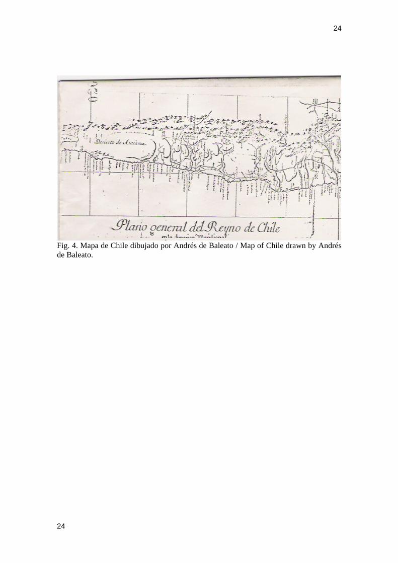
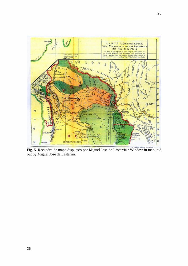
to Mr Andrés de Baleato, a lieutenant graduated from the Lima Nautical Academy. He, for a complete fulfilment of the task, performed his study supported on the most modern maps in existence. The “General Plan of the Kingdom of Chile”… which covers from 21 ½ (Río Loa) to 47 degrees latitude south… was completed in the year 1793. The toponym “Atacama Desert” is written from the south of Río Loa to the height of “Bahía de Nuestra Señora (del Paposo). However, the map by the same author, General plan of the Kingdom of Peru…which covers from the Equinoctial to 26 ½ degrees Latitude south….” Implies the express desire by Baleato of not following the map by Juan de la Cruz y Cano de Olmedilla on this point, since from the maps of Peru and of Chile it is inferred that the Uninhabited Atacama necessarily belonged to Chile or to Peru, but under no circumstances to the Viceroyalty of Buenos Aires. This great mix up would be explained because Baleato followed the map of “South America” by Juan de la Cruz y Cano de Olmedilla almost to the letter, since this map shows the “Uninhabited Atacama” as an integrant of the jurisdiction of the Audience of Charcas, in accordance with the erroneous information coming from the map by Tomás López. Baleato cited the map “by Cruz” in his explanatory notes accompanying the map of Chile. In finishing the chronological lecture of the major maps regarding the jurisdiction which the “Uninhabited Atacama” belonged, we believe it of interest to display the map which shows on a window on the right hand edge of the illuminated planishpere called “GEOGRAPHICAL MAP OF SOUTH AMERICA, PART OF AFRICA AND ASIA….. laid out by Mr Miguel de Lastarria and Drawn by Mr Francisco Fernández” (Guillén y Tato, 1942). The most important map on the foregoing window carried the title “COROGRAPHIC CHART of the Viceroyalty of the Provinces of Río de la Plata” (Calvo, 1862). What is most important for the thesis which has been demonstrated in this research, lies in that even though this map contains almost the same elements which the map by Joaquín Alós already commented, it substantially difference from it is that it highlights with a red line the southern boundary of Peru over Río Loa. While the territories of the intendancies of Charcas are illuminated with dark green, light green and pale pink colours, the territories of the Viceroyalty of Peru and the “Uninhabited Atacama” are absolutely in white, which evidently shows that territories to the south of Río Loa belonged neither to the department of Lipes nor to the department of Potosí. Graduate Miguel José de Lastarria must have been intimately persuaded that the “Uninhabited Atacama” could not have belonged to the Audience of Charcas because no express measure from the Monarch ever existed to attribute such jurisdiction. This issue had to be very well known because of the concerns which he had to attend as secretary to the Marquis of Avilés between 1796 and 1801, during the performance by the former as Governor of Chile and then as Viceroy of Río de la Plata. THE UNINHABITED ATACAMA DURING THE REPUBLIC
16
17
In accordance with the Constitution enforced by O’Higgins in1823, considered as Chilean territory was the extension from the Atacama Desert to Cape Horn. It was President Bulnes who set degree 23 as northern boundary considering the acts of maritime vigilance against corsairs and acts of material possession undertaken by Chile in the Desert, all this in strict compliance with the obligations imposed by the Viceroys of Peru since said acts could not be undertaken from Lima. Only many years later, historian José Toribio Medina found in a dossier formed in a lawsuit followed by Francisco de Aguirre, a copy of the provision of Gasca in which Pedro de Valdivia was given the jurisdiction of the territory which began in the valley of Copiapó. Since the expression “Valley” applies both to the basin of a river and to a range between mountains, it is not strange for Chronicler López de Velasco to consider that the ‘Apachetas’ marked the beginning of Chile from the Incas times. As it may be seen, the inaccuracy was enormous. These uncertainties perfectly explain why upon commencing the Chilean exploitations of guano deposits from sea birds and then nitrate, Bolivia began showing its opposition to said exploitations. General Melgarejo, owner of agricultural and mining land in Antofagasta de la Sierra must have known that the boundaries of the Bolivian jurisdiction were remitted to the space lying within one hundred leagues with its base on the city of La Plata, less the coastline valleys which Philip II subtracted from it due to the effect of the Royal Decree of 1563 which passed on to the Compendium as Law V, since it left the entire coastline up to the ports of Chile under the sole jurisdiction of Lima. In exchange for this situation, Philip II added to it the territories of Tucumán, Juríes and Diaguitas. For this reason Melgarejo accepted the good transaction of 1866 proposed by his Minister Donato Muñoz, each time that he knew perfectly well that the territory of Tucumán never extended to the valleys of the coastline and therefore it was a highly advantageous acquisition to them to legally put right an exit to the Pacific between degree 24 and the mouth of Río Loa. In 1869, in common agreement, the Pissis-Mujía Commission was formed to recognise in the field latitudes 23, 24 and 25 and to fix in the east the anticline line of the Andes. These representatives were in agreement in that this latter section went from Licancabur and Tonar volcanoes, 23º, passing along Apagado-Pulgar volcano, 24º, till Llullaillaco volcano on 25º. Melgarejo was overthrown in 1871 and Bolivia declared null all decrees signed by him and especially the treaty of 1866, not being aware that this implied disavowing international juridical responsibilities stemmed under the protection of a freely convened agreement of boundaries. Later, the Treaty of 1874 was signed. This latter once again fixed the boundary between the Republics of Chile and Bolivia “latitude degree 24 from the sea to the Cordillera de los Andes in the divortia aquarum”, also establishing in article IV that the exploitation rights imposed on minerals exported in the territory between latitudes 23 and 25 south “did not exceed the quota of what is currently charged, and the Chilean persons, industries and capitals would not remain subject to more rates of any type whatever than those currently in existence. The stipulation contained in this article will last for a twenty five year term” (sic).
17
18
A few years later, Bolivia established a new tax protected in a secret treaty of mutual defence signed with Peru. Through the effect of the breach of the treaties, a war was declared at the end of which Chile acquired as a war indemnity the provinces of Tarapacá and Antofagasta. From this research it is inferred that even though Chile acknowledged to Bolivia a jurisdiction to the north of degree 23, Chile did so due to an absolute ignorance of the corresponding historic background. Among that lack of knowledge is the authentic application of the Royal Decree of 1563 through which Philip II removed from the Audience of Charcas every possibility of access to the Pacific. Recall that in exchange for removing from it said jurisdiction over the coastline, he gave it numerous territories located to the east of the Andes. For this reason, Charcas had no other jurisdictional district than that fixed in said law, that is, without access to the Pacific and increasing its territory to the east of the western Cordillera de los Andes. A Royal Decree which declared successor of the Almagro’s New Toledo never existed, an error which Santa Cruz passed on to López de Velasco, to Herrera and of which León Pinelo fraudulently took advantage. From the foregoing, as evidence it is inferred that the Royal Decree which gave the Viceroyalty of Lima the exclusive jurisdiction of all ports located between Paita and Copiapó was always fully in effect since its enacting. Under no circumstances could it be sustained that the acting by Charcas in Cobija could have generated some right born from USE and CUSTOM, each time Law I, Title I, Book V of the Compendium showed that such situations should be protected in the most authentic LEGITIMACY. Smuggling was never legitimate. To conclude, it would be worth while placing in relevance that Bolivia never cited any legal title whatever to sustain its aspirations to the coastal area provinces than its hypothetical consideration to feel the continuer of Almagro’s legislation over New Toledo, which Bolivia well knew that it did not correspond to any correct juridical interpretation. This was a historic reality that was totally contradictory with the obligations imposed on Chile by the Viceroys of Peru, by virtue of Law V of 1563, so many times cited, so that it permanently watched over the entire coastline of the Uninhabited Atacama and with the inferred authorisation to take possession of all ravines where water formed by the ‘camanchaca’ could be born, which is highly habitual on the coastal area and which could be used by corsairs and smugglers. The possession acts undertaken by Chile by virtue of administrative measures by the Crown and free from all vice of force, clandestinity or precarious were from those situations which gave rise to the international agreement called “Uti Possidetis of 1810” at the Congress of Panama, cited by Bolívar in 1829. These principles were once again set forth by Chile at the Congress held in Lima in 1865, but these did not obtain a general sanction because the Argentinean delegate Domingo Faustino Sarmiento did not feel especially authorised by his government for it. Thus, the Treaties of 1866 and 1874 signed between Chile and Bolivia would have been enormously profitable to its interests, but its unwarranted abrogation meant taking charge of the consequent war indemnities stemmed from the breach of a validly celebrated international treaty.
18
19
Three years after the war ended, in 1884 a Pact of Truce with Bolivia was signed. This treaty gave Chile the administration of the territories located to the south of latitude 23 and to the east of Zapaleri volcano. This study it may not be concluded without stating that Argentinean ex Foreign Relations Minister Estanislao Zeballos published in 1894 a large map of South America to show that some territories in the region of Misiones which belonged to Argentina were in the hands of Brazilian authorities. This map shows a thick blue line separating the boundaries of Chile with its north-eastern neighbours, leaving the entire coastline of Tarapacá and Atacama under the unquestioned jurisdiction of Chile. This would explain why Argentina, in the Puna de Atacama proceedings never made their the claims set forth by all Bolivian ministers who believed having some right to the desert located to the west of the Cordillera de los Andes. The fact that León Pinelo has fraudulently forged Law IX so many times cited, makes the map by Tomás López equally illegitimate with regard to the coastal area provinces of Tarapacá and Antofagasta and it also leaves without value all later commentators and geographers who did not become aware of his snare. Although it is a generally accepted juridical principle that the common error constitutes a Law, this is absolutely inapplicable to situations created through FRAUD since this constitutes the antithesis of good faith, soul of Law. The ancient Roman wisdom based the essence of Law on the very ancient aphorism “DO UT DES; DO UT FACIAS; FACIO UT DES; FACIO UT FACIAS”. “I give so that you give; I give so that you do; I do so that you give; I do so that you do”. As a consequence of Pinelo’s fraudulent action, the measures of Law IX which granted apparent rights to Charcas to exit to the Pacific, turned out to be absolutely inexistent and simply it must be considered unwritten since it contradicted the most clear will by Philip II in this regard, which was never expressly repealed by later Monarchs. Had Charles III desired to modify Philip II’s will by finding satisfactory the work done by later cartographers, he should have expressly said so without hesitation. The jurisdiction of sovereignty could only be distributed by the Sovereign, never the bad faith let alone when an inventory was taken of the measures. The cartographers never had attributions to modify the royal will. The juridical inexistence, by being such, is essential. Other Works by the Author on Cartographic History: - “Columbus on the route of the Phoenicians and Carthaginians” book published under the sponsorship of Sociedad Chilena de Historia y Geografía. Un inedited English edition exists. - “The Cartography of Ancient Times should have been drawn through a marine quadrant and a pair of compasses, because the magnetic needle does not give distances”, work published in “Revista de Historia de América”, number 129, July-December 2001, by Instituto Panamericano de Geografía e Historia. - Web Page www.protohistoriageografica.cl, year 2005, “Homer travelled to the Arctic Circle on board of a Phoenician ship”. References to “Ancient Map” known by Eratosthenes and very ill attributed to Ptolemy.
19
20
I would like to take the opportunity of the universal extension of eventual readers to set forth two doubts in a POST SCRIPTUM, that I have with regard to the manner in which man could capture in such a remote era that the Earth rotated around the sun and not the other way round, which allowed the Chinese astronomer Yu the Great to construct the first geographic maps allowing him to build the Great 5,000 Km long Chinese Wall. I deem that for this, Yu could observe that the carpenter’s plumb moved a minimum even when there was no wind and this was possible only by accepting that it was the Earth that moved. Hence that he had invented a top to show that the Earth not only rotated on itself but also that it transferred around a far more ample point, there is but one single step. If not so, how could the map of the known world which Eratosthenes called the “Ancient Map” be constructed since in his time already nobody knew what its origin and neither its age had been? Many of these statements are included in my web page cited at the end of my work in order to give the reader a better orientation. I wish to set forth these questions just in case somebody would be so kind as to help me with this research. BIBLIOGRAPHY - Calvo, Carlos, in “Complete collection of the treaties and other diplomatic acts of all Latin American States”, Oaris, A. Durand’s Bookshop, 1862,Tome IV, states that in the Paris Imperial library is the “Memoir on the dividing line of His Catholic Majesty and of the King of Portugal in South America”, work by Lastarria, forming part of several explanatory papers and maps on Río de la Plata, bound in two volumes in folio and numbered 4486, 4486, 2nd Supplement, in accordance with Florencio Varela. - Eyzaguirre, Jaime. “Chile and Bolivia. Scheme of a diplomatic process”, page 15, Santiago, Chile, 1963. - Guillén y Tato, Julio F., Frigate Captain, “MONUMENTA CHARTOGRAPHICA INDIANA”, publication of the Cultural Relations Section of the Ministry of Foreign Affairs, Madrid, 1942. Map reproduced in black and white and in reduced size in “MONUMENTA CHARTOGRAPHICA INDIANA”, under Nº 44, Ms. Nº 1326. - Levillier, Roberto, “Audience of Charcas. Correspondence by Presidents and Judges.. Documents from Archive of Indies”, Tome I, p. 588, Collection of Historic Publications of the Congress Library of Argentina, Madrid, 1918. - León Pinelo, Antonio de, “The Great Chancellor of Indies”, edited by himself in 1624 and made known recently by the great Peruvian researcher Guillermo Lohmann Villena, Seville, 1953, p. 118 and 119. FIGURAS / FIGURES
20
21
Fig. 1. Mapa “Los Charcas. El Obispado de N. Sra. De la Paz y el de Sta. Cruz de la Sierra” dibujado por Tomás López, 1758 /Map “Los Charcas, The Bishopric of Our Lady of the Peace and of Santa Cruz de la Sierra”, drawn by Tomás López, 1758.
21
22
Fig. 2. Detalle de las costas de la Audiencia de Charcas en Mapa 12 dibujado por Alonso de Santa Cruz y publicado por Antonio de Herrera en 1602 /Detail of the coasts of the Audience of Charcas in Map 12 drawn by Alonso de Santa Cruz and published by Antonio de Herrera in 1602.
22

23
Fig. 3. Desierto de Atacama en detalle del mapa de “América Meridional”, dibujado por Juan de la Cruz y Cano de Olmedilla, siguiendo a Tomás López / “Atacama Desert” in detail of the “South America Map”, drawn by Juan de la Cruz y Cano de Olmedilla, following to Tomás López.
23
24
Fig. 4. Mapa de Chile dibujado por Andrés de Baleato / Map of Chile drawn by Andrés de Baleato.
24
25
Fig. 5. Recuadro de mapa dispuesto por Miguel José de Lastarria / Window in map laid out by Miguel José de Lastarria.
25
26
26
Fig. 6. Detalle del mapa de Estanislao S. Zeballos, 1894 / Detail of the map by Estanislao S. Zeballos, 1894.