Estrategias sociales de prevención y adaptación Social Strategies ...
152
Estrategias sociales de prevención y adaptación Social Strategies for Prevenon and Adaptaon Virginia García Acosta, Joel Francis Audefroy & Fernando Briones Coordinadores/Coordinators
Transcript of Estrategias sociales de prevención y adaptación Social Strategies ...
Estrategias socialesde prevención y adaptación
Social Strategiesfor Prevention and Adaptation
Virginia García Acosta, Joel Francis Audefroy & Fernando Briones
Coordinadores/Coordinators


Estrategias socialesde prevención y adaptación
Social Strategiesfor Prevention and Adaptation
Virginia García Acosta,Joel Francis Audefroy& Fernando Briones
Coordinadores/Coordinators
Este documento se ha realizado con la ayuda financiera de la Comunidad Eu-
ropea y los Estados Unidos Mexicanos. El contenido de este documento es res-
ponsabilidad exclusiva de las instituciones participantes y en modo alguno debe
considerarse que refleja la posición de la Comisión Europea ni del Conacyt.
Primera edición: 2012
D.R. © Centro de Investigaciones y Estudios Superiores en Antropología Social
(ciesas)
Juárez, 87, Col. Tlalpan, C.P. 14000, México D.F.
Red sobre riesgo y vulnerabilidad
<http://redriesgoresiliencia.ciesas.edu.mx/>
ISBN: 978-607-486-172-3
Impreso y hecho en México
363.34E582e Estrategias sociales de prevención y adaptación = Social Strategies for Prevention and Adaptation / Virginia García Acosta, Joel Francis Audefroy y Fernando Briones, coords.--México : Centro de Investigaciones y Estudios Superiores en Antropología Social, 2012 151 p. : il. maps. tabs. gráfs. ; 28 cm.
Resumen e introducción en español e inglés. Incluye bibliografía.
ISBN: 978-607-486-172-3
1. Desastres y amenazas naturales – Investigación. 2. Vulnerabilidad social. 3. Educación en desastres. 4. Desastres – Prevención. 5. Cambios climáticos. 6. Administración de emergencias. 7. Hidrometeorología. I. García Acosta, Virginia, coord. II. Audefroy, Joel Francis, coord. III. Briones, Fernando, coord. IV. Social Strategies for Prevention and Adaptation.
5
Miembros y colaboradores / Members and Collaborators
Red sobre riesgo y vulnerabilidad /Risk and Vulnerability Network
Miembros socios / Participating Members
• Centro de Investigaciones y Estudios Superiores en Antropología Social (ciesas, México)
Coordinación general / General Coordination Virginia García Acosta & Fernando Briones
• Instituto Politécnico Nacional (esia-tec, México)
Joel Francis Audefroy
• Politecnico di Milano (Italia)
Scira Menoni
• University of Helsinki (Finland)
Jussi Pakkasvirta & Florencia Quesada
Colaboradores / Collaborators
• Wageningen University (Netherlands)
Thea Hilhorst & Jeroen Warner
• Development Workshop France (dwf, France)
John Norton
• El Colegio de la Frontera Sur (ecosur, México)
Dora Ramos

7
Red sobre riesgo y vulnerabilidad: estrategias sociales de prevención y adaptación
Objetivo generalRecuperar el conocimiento ancestral, culturalmente construido y asociado a la prevención de riesgos ante amenazas hidrometeorológicas recurrentes en México y Europa.
Las sociedades han imaginado, creado, construido, rechazado y vuelto a imaginar, crear y construir estrategias diversas que les permitan hacer frente y, sobre todo, prevenir los efec-tos relacionados con la inminente presencia de una amenaza natural.
Estos procesos están indefectiblemente asociados y son el resultado del entorno en el cual se desenvuelve una determinada sociedad, es decir son producto de una determinada cultura.
Risk and Vulnerability Network: Social Strategies of Prevention and Adaptation
General Objective Recuperate ancestral and vernacular knowledge culturally developed and associated with risk prevention in face of recurrent hydro-meteorological hazards, both in Mexico and Europe.
Societies have imagined, created, constructed, rejected and returned to imagine, create and construct diverse strategies that allow them to face and, above all, to prevent the effects related to the imminent presence of a natural hazard.
These processes are unfailingly associated and are the result of the conditions in which a certain society develops, that is to say, they are product of a certain culture.

8
Agradecimientos
Este trabajo es uno de los productos del proyecto internacional Red sobre riesgo y vulnerabili�dad: estrategias sociales de prevención y adaptación (redriesgoresiliencia: http://redriesgoresi-liencia.ciesas.edu.mx/) que se llevó a cabo de junio 2010 a junio 2011 con sede en el ciesas. Este proyecto fue financiado en el marco de la Cooperación México-Unión Euro-pea por el Foncicyt, Fondo de Cooperación Internacional en Ciencia y Tecnología que acor-daron en 2007 México y la Unión Europea.
Agradecemos a las personas e instituciones que han permitido que este trabajo se llevara a cabo:
Enrique Villa Rivera, Director General del Conacyt.Leonardo Ríos Guerrero, Director Nacional del Foncicyt.Marie-Anne Coninsx, Embajadora-Jefa de la Delegación de la Unión Europea en México.Igualmente el apoyo para su desarrollo de: Israel Sanabria Pizarro, Claudia Villegas, Myriam de la Parra, Pablo Acosta y Magdalena Hernández.
Acknowledgments
This work is a product of the international project Risk and vulnerability network: social strate�gies for prevention and adaptation (redriesgoresiliencia: http://redriesgoresiliencia.ciesas.edu.mx/) that was held from June 2010 to June 2011, based on ciesas. This project was funded under the EU-Mexico cooperation by Foncicyt, Fund for International Cooperation in Science and Technology agreed in 2007 between Mexico and the European Union.
We thank the people and institutions that have enabled this work to be carried out:
Enrique Villa Rivera, General Director Conacyt.Leonardo Ríos Guerrero, National Director Foncicyt.Marie-Anne Coninsx, Ambassador-Head of the Delegation of the European Union in Mexico.Also the support for its development to: Israel Sanabria Pizarro, Claudia Villegas, Myriam de la Parra, Pablo Acosta and Magdalena Hernández.

9
Índice / Contents
Introducción/ Introduction Virginia García Acosta, México ............................................................................... 11
Casos europeos / European Cases
1. The Shadow of the Past in Dutch Flood Management: The Rediscovery and Politicisation of “Best Practices” ........................................ 25 Jeroen Warner, Netherlands.
2. Measuring the Vulnerability and Resilience to Hydrogeological Risks: results and applications of the ensure EU funded project ………………… ............ 47 Scira Menoni, Italia.
3. Impacts of Climate Change on Hydrology in Finland, Adaptation Possibilities by lake regulation .............................................................................. ................. 57 Juho Jakkila, Noora Veijalainen, Bertel Vehviläinen & Teemu Nurmi, Finland.
4. La Faute-sur-Mer disaster ……………………………………………… ................... 63 Patrick Pigeon, France.
Casos asiáticos / Asian Cases
5. More to Lose: Reducing Family Vulnerability to Flood and Storm Damage in central Vietnam, 1989-2010 ……………………………………….. ..................... 71 John Norton & Guillaume Chantry, France.
6. Sustainability and Feasibility of Insurance Tools for Compensating Losses due to Natural Hazards in Vietnam ………………………………… ........... 75 Huong Tra Nguyen & Scira Menoni, Italia.
7. Reducing the Risk of Disaster Through Participatory Mapping in Irosin, Philippines ……………………………………………. .............. 81 Jake Rom D. Cadag, France. J.C. Gaillard, New Zealand. Arturo Francisco & Arze Glipo, Philippines.
10
Casos latinoamericanos / Latin American Cases
8. Floods in Matina, Caribbean Coast of Costa Rica: Social Strategies for Prevention and Adaptation ............................................................................ 91 Florencia Quesada, Finland.
9. Adaptación de la vivienda vernácula a los climas en México …………… .............. 95 Joel F. Audefroy, México.
10. Saberes climáticos en la agricultura de los ch’oles de Chiapas ………….. .............. 107 Fernando Briones, México.
11. Las sequías en el área maya: estrategias tecnológicas y adaptativas …… ................ 113 Joel F. Audefroy & Bertha Nelly Cabrera Sánchez, México.
12. Cuando el agua corre... Estrategias y prácticas espaciales para convivir con fenómenos hidrometeorológicos. El caso de la ciudad de Campeche, México.. 123 Jimena Cuevas Portilla, México.
Casos de África del Oeste / West African Cases
13. Reducing the Growth of the Deserts: Developing Local Skills to Reduce the Overconsumption of Timber in Construction ................................................ 135 John Norton, France.
Sobre los autores / Biodatas ................................................................................ 139

11
Introducción
Virginia García Acosta, ciesas, México
Las redes sociales, como afirma el sociólogo Manuel Castells, son tan antiguas como la humanidad misma, pero en la actualidad han cobrado nuevas formas; constituyen la estructura organizativa de nuestro tiempo.1 Una red es un conjunto de nodos interco-
nectados; no tiene un centro, sólo nodos, a través de los cuales se distribuye el conocimiento y se toman decisiones. La flexibilidad y la adaptabilidad inherentes a las redes modernas les dan gran ventaja sobre otros tipos de organizaciones anteriores de carácter racional y jerár-quico, nos dice Anthony Giddens.2 Los avances en las tecnologías de la información y de la comunicación han influido de manera definitiva en ello, al permitir disminuir y hasta elimi-nar las barreras que constituyen el espacio y el tiempo.
El despliegue precisamente de una red, la “Red sobre riesgo y vulnerabilidad: estrategias sociales de prevención y adaptación”, constituye el resultado más relevante de uno de los exi-tosos proyectos Foncicyt que, habiéndose concebido hace ya cerca de cuatro años, culmina su fase final con esta publicación que ofrecemos a los especialistas interesados en el tema.
La convocatoria del Fondo de Cooperación Internacional en Ciencia y Tecnología entre México y la Unión Europea (Foncicyt), sustentado en el convenio firmado entre el Conacyt de México y la Comunidad Europea, fue publicada en 2008. Tenía tres objetivos su lanza-miento: fortalecer las capacidades científicas de todos los participantes; contribuir a com-prender y por lo tanto posibilitar la generación de propuestas de solución a problemas comunes a toda la comunidad internacional en temas medioambientales y socioeconómi-cos; y fomentar la cooperación entre México y la Unión Europea a partir del enriquecimien-to con enfoques locales y regionales. Su instrumentación se llevó a cabo a través del apoyo financiero para conformar redes internacionales o bien para desarrollar proyectos de investi-gación compartidos en los países involucrados.
Un grupo de investigadores sociales mexicanos encontró en esta convocatoria una opor-tunidad valiosa para lanzar una propuesta ambiciosa: la conformación de una red mexica-no-europea de especialistas en riesgo y desastres, enfocados particularmente hacia la búsqueda de las claves para incrementar las posibilidades de prevención de los desastres. Una de las ideas medulares fue la de recuperar las lecciones existentes sobre prácticas que han incrementado las posibilidades de sobrevivencia de grupos expuestos a condiciones de riesgo. Pocas de ellas se han convertido realmente en lecciones aprendidas, la mayoría al-canza a ser apenas identificada alrededor de la denominada gestión integral del riesgo.
1 Manuel Castells (2000), La sociedad red, Madrid, Alianza Editorial.2 Anthony Giddens (2009), Sociología, Madrid, Alianza Editorial.

12
Este grupo, al que podemos denominar la red original, estuvo conformado por tres in-vestigadores con trayectorias profesionales y edades heterogéneas, pero con elementos muy valiosos en común que convenía potenciar al trabajar conjuntamente: ser parte de redes te-máticas; tener contactos de diversa índole con investigadores europeos especialistas en estos temas y, sobre todo, compartir hipótesis y concepciones comunes en temas vinculados con los desastres. Entre estas últimas podemos mencionar las siguientes:
a) Las sociedades no son y nunca han sido entes pasivos ante la presencia de amenazas naturales.
b) Históricamente, las comunidades han formulado caminos sociales y culturales para en-frentarse a riesgos y desastres potenciales.
c) Las sociedades han desarrollado, a lo largo de la historia, estrategias sociales de preven-ción y adaptación en su interacción con el medio natural.
Con estas hipótesis como eje, consideramos que resulta urgente identificar, recuperar, reforzar y actualizar esas estrategias, esas construcciones culturales identificadas como “me-jores prácticas” o “prácticas efectivas”, que refuercen las posibilidades de desplegar accio-nes para aprovechar las posibilidades de resiliencia del grupo social. Dicho rescate debe hacerse privilegiando la escala local y regional, y de manera comparativa en distintas latitu-des y culturas.
Decidimos presentar a la convocatoria del Foncicyt una propuesta para conformar y desplegar una Red y no desarrollar un Proyecto de investigación, a partir de considerar que la temática sobre riesgo y desastres, particularmente desde la perspectiva de las ciencias so-ciales, si bien no fue atendida por décadas, ha logrado avances muy importantes en los últi-mos 20 años. La investigación de vanguardia se ha dirigido precisamente a la identificación de los factores que incrementan la vulnerabilidad; de los elementos que inciden en la cons-trucción de riesgos y en los agentes que provocan que los desastres sean cada vez más des-tructivos. Los intereses centrados en la deconstrucción de riesgos, en la resiliencia, en las culturas del riesgo o del desastre, en las estrategias de sobrevivencia o estrategias adaptati-vas, están todavía dispersos. No se ha logrado articular y sistematizar el conocimiento rela-cionado con estos asuntos, de manera que permita aprovechar los avances que se han alcanzado a partir de los estudios llevados a cabo en los diversos centros de investigación y universidades de países en ambos continentes. Había entonces, antes de iniciar proyectos de investigación conjuntos, que integrar a los investigadores para recuperar el acervo de esfuer-zos individuales en la temática y compenetrarse con los temas y las corrientes que se han desarrollado a lo largo del tiempo como esfuerzos de investigación individuales y aislados.
A partir de la integración de la Red ha sido factible identificar las capacidades científi-cas y tecnológicas complementarias de sus integrantes, para con ello ya iniciar esfuerzos de investigación conjunta con bases firmes y horizontes bien delineados, aprovechando tam-bién las alianzas que estos participantes han desarrollado en diferentes latitudes.
Esta nueva forma de abordar la investigación, de enriquecer la generación de conoci-miento a partir de “redes de redes” sobre temas específicos de preocupación universal para
13
las sociedades humanas modernas, permitirá una potencia de búsqueda y exploración tal que será factible encontrar soluciones con mayor cimentación que las que se pueden alcan-zar a partir de esfuerzos de investigación individual y desarticulados. Las redes en esencia permiten articular el conocimiento a través de enfoques transdisciplinarios y en este caso multigeográficos y multirregionales, para tener la posibilidad de observar y conocer los fe-nómenos con una perspectiva integral.
Las redes se alimentan de capital social, tal como lo enunciara Pierre Bourdieu, el pri-mer estudioso en articular una definición de ese concepto.3 A su vez las redes, creadas y arti-culadas adecuadamente, son generadoras de capital social, entendido éste como el conjunto de recursos reales o potenciales a disposición de los integrantes de una red durable de rela-ciones más o menos institucionalizadas. Red y capital social resultan dos elementos indiso-lubles, tanto en la conceptualización de Bourdieu, como en la que le dieran más tarde James Coleman o Robert Putnam.4 La generación de capital social o el aprovechamiento del capital social inmerso en un grupo es pues el cemento para el despliegue de las redes.
La Red que ahora denominamos Red Riesgo Resiliencia (rrr) y que hemos ido confor-mando en estos años, se ha reforzado a partir del desarrollo de talleres y de un “evento para-lelo”, celebrados con apoyo de la Universidad de Helsinki (Helsinki, mayo-junio, 2010), de la Universidad de Luxemburgo y el Consorcio risc (Luxemburgo, noviembre, 2010) y del ciesas en su Unidad Peninsular (Mérida, México, febrero, 2011). Con estas actividades se han logrado construir puentes y se han desplegado vinculaciones que fructificarán en el fu-turo trabajo de investigación conjunto.
El punto culminante para la articulación de esta Red fue el Seminario Internacional que organizamos en la ciudad de México, y que se llevó a cabo en febrero de 2011 en la sede Distrito Federal del ciesas, que ha sido la sede de este Proyecto-Red Foncicyt. En este Se-minario se contó con la participación de especialistas en las temáticas de la rrr provenien-tes de cuatro países americanos y seis europeos, presentando una docena de ejemplos europeos, asiáticos y latinoamericanos.
La construcción de una red sobre estrategias adaptativas frente a desastres ha significa-do, de hecho, la cimentación de una “red de redes”, al haber fortalecido de manera signifi-cativa redes diversas y dispersas sobre riesgo, desastres y temáticas asociadas a ellos, previamente existentes en diferentes regiones y países. Entre ellas podemos mencionar la Red de Estudios Sociales en Prevención de Desastres en América Latina (la red), la red Hábitat en Riesgo del Programa Iberoamericano de Ciencia y Tecnología para el Desarrollo (cyted xiv-g), entre otras. En Europa existen redes informales de investigadores y redes de organizaciones no gubernamentales (ong), que trabajan en cuestiones de riesgo y desas-
3 Pierre Bourdieu (1986), “The forms of capital”, en Handbook of Theory and Research of the So�ok of Theory and Research of the So�ciology of Education, John Richardson (comp.), Nueva York, Greenwood Press.
4 Virginia García Acosta (2009), “Prevención de desastres, estrategias adaptativas y capital so-cial”, en Social Cohesion in Europe and the Americas: Power, Time and Space, Harlan Koff (ed.), Peter Lang-Editions Scientifiques Internationales/Regional Integration and Social Cohesion Series, vol. 3, pp. 115-130.
14
tres, con particular énfasis en aquéllos asociados con amenazas hidrometeorológicas. Éstas se han vuelto el centro de las preocupaciones de los investigadores, especialmente a partir de los resultados del Panel Intergubernamental sobre Cambio Climático (ipcc por sus siglas en inglés) y, en Europa en particular, después de publicado el controvertido reporte de Nicho-las Stern quien, basado particularmente en los impactos económicos del cambio climático, afirmó que la evidencia científica daba cuenta de la existencia de riesgos globales que de-mandaban atención y respuestas urgentes.5 Este reporte insiste en los complejos desafíos en materia de política pública a escala local, particularmente los relacionados con asegurar que las sociedades puedan adaptarse a los efectos e impactos diversos del cambio climático.
Como mencioné antes, durante los últimos años que para algunos corresponden a déca-das, quienes ahora conformamos la rrr nos hemos dedicado a estudiar y analizar la cons-trucción social de riesgos, es decir a identificar y entender los elementos que han provocado que la acumulación histórica de riesgos y vulnerabilidades den lugar a desastres con resulta-dos cada vez más dramáticos. Toda esa experiencia de investigación, y en algunos casos de investigación-acción, nos ha llevado a enfocar nuestras preguntas, nuestras búsquedas hacia otro derrotero que puede sintetizarse en la siguiente pregunta-eje: ¿qué han hecho las socie-dades históricamente para enfrentar las amenazas naturales, particularmente aquéllas que son recurrentes? Resulta fundamental recuperar, reconstruir y documentar ésas que llama-mos “culturas de prevención” a escala global, pero con una mirada centrada en las solucio-nes exitosas a nivel local y regional.
En el proyecto para integrar esta Red, los talleres que se organizaron, el Seminario In-ternacional llevado a cabo en el ciesas y, en suma, el producto final que es la Red Riesgo Resiliencia (rrr) abonará a estas preocupaciones tanto en su aspecto científico como en su traducción para el diseño y definición de políticas públicas orientadas a la prevención.
Hemos avanzado poco a poco, y habrá que seguirlo haciendo en el futuro cercano, con los objetivos planteados por este Proyecto-Red Foncicyt, particularmente en lo que se refiere a:
a) Recuperar el conocimiento ancestral y culturalmente construido asociado a la preven-ción de riesgos ante amenazas naturales.
b) Reconstruir las “culturas de prevención” a escala global, con una mirada local y regio-nal.
c) Identificar y tipificar las estrategias de prevención y adaptación (la “adaptación resiliente”).6
d) Introducir en el debate internacional, así como en las políticas públicas a escala local y regional, la dimensión cultural de los grupos vulnerables sometidos a determinadas amenazas naturales.
5 Nicholas Stern (2007), The economics of Climate Change, Cambridge, Cambridge University Press. 6 Michael H. Glantz (2010), Resilient Adaptation: Coping with an uncertain future, conferencia, Seminario Clima y
Sociedad, 7 de abril, ciesas, ciudad de México.
15
En esta publicación damos a conocer una serie de estudios de caso que, como producto de investigación directa, han resultado del trabajo empírico desarrollado por los miembros originales, así como de aquéllos que se han ido sumando a la rrr. Todos ellos dan cuenta de una “red de redes” que se ha ido conformando a lo largo de estos pocos años de desarrollo de la rrr, y muestra las posibilidades futuras que ello tiene en un trabajo científico, com-partido y comparativo entre México y Europa, entre Latinoamérica y Europa, entre diferen-tes regiones de todo el planeta. En cada una de ellas las sociedades enfrentadas a la presencia de amenazas recurrentes de origen natural, han desarrollado estrategias sociales y culturales que debemos recuperar, adaptar y adoptar, transformándolas en políticas públicas aplicables a nuestras específicas realidades locales.
En resumen, este Proyecto-Red Foncicyt estuvo dirigido a conformar redes temáticas en un diálogo norte-sur, comparando realidades diversas e identificando metodologías comu-nes, con el objetivo de articular proyectos de investigación robustos a través de aprovechar las experiencias y las capacidades en diversidad de geografías, así como a través del trabajo transdisciplinario, comparativo y creativo.
Los proyectos que se vinculan a desastres tienen cada vez más atención internacional, dados los efectos devastadores que ocasionan en términos de vidas humanas y pérdidas ma-teriales de grupos altamente vulnerables. Es indispensable que los científicos unamos esfuer-zos para responder con eficiencia a esta demanda universal. Las ciencias sociales en este campo tienen la oportunidad de demostrar que son indispensables para resolver los grandes problemas que aquejan a los grupos humanos que se encuentran en condiciones vulnerables y ante riesgo de desastre.
Contacto Virginia García Acosta, ciesas, México, <[email protected]>.


17
Introduction
Virginia García Acosta, ciesas, Mexico
Social networks, as Sociologist Manuel Castells has pointed out, are as old as humanity itself; they have recently, however, adopted new forms; they constitute the organiza-tional structure of our time.1 A network is a set of interconnected nodes; there is no
center to it, only nodes through which knowledge is distributed and decisions are made. The flexibility and adaptability that are inherent to modern networks give them a great advantage over other, older types of organization of a rational and hierarchical nature, Anthony Gid-dens points out.2 The advances in information and communication technologies have had a decisive influence on this, minimizing and even eliminating space and time barriers.
It is precisely the deployment of a network, the “Network on risk and vulnerability: so-cial strategies for prevention and adaptation”, which constitutes the most relevant result of one of Foncicyt’s successful projects which, having been conceived some four years ago, reaches its final phase with this publication which we are now putting at the disposal of spe-cialists interested in the topic.
The invitation made by the Science and Technology International Cooperation Fund (Foncicyt, by its Spanish initials), based on the Agreement signed by Mexico’s Conacyt and the European Union, was published in 2008. It was launched in pursuit of three goals: to strengthen the scientific capabilities of all participants; to contribute to understanding and therefore enable the generation of proposals aiming to solve problems that are common to all the international community in connection with environmental and socio-economic matters; and to promote cooperation between Mexico and the European Union based on contributions with a local and regional focus. It was implemented through financial support earmarked for the creation of international networks or for the development of research projects between participating countries.
A group of Mexican social researchers found this invitation to be a valuable opportuni-ty for launching an ambitious proposal: the constitution of a Mexican-European network of specialists on risk and disasters, with the specific aim of finding key factors that would in-crease the possibility of preventing disasters. One of the central ideas of the project was to make use of existing lessons deriving from those practices that have increased the chances for survival of groups exposed to risk. Few of these have become learned lessons; most of them have barely been identified within so-called comprehensive risk management.
This group, whom we may refer to as the original network, was made up of three re-searchers with heterogeneous professional histories and ages, but who had valuable elements
1 Manuel Castells (2000), La sociedad red, Madrid, published by Alianza Editorial.2 Anthony Giddens (2009), Sociología, Madrid, published by Alianza Editorial.

18
in common the leverage of which, through collaboration, was deemed convenient. This le-veraging contemplated integrating them to topical networks; enabling them to have different kinds of contacts with European researchers specializing on these topics; and, above all, to share common hypotheses and ideas connected with disasters. Among the latter, the follow-ing are worth mentioning:
a) Societies are not and have never been passive entities in the face of natural hazards.b) Historically, communities have formulated social and cultural ways to deal with poten-
tial risks and disasters.c) Throughout history, societies have developed social strategies for prevention and adap-
tation in their interaction with the natural world.
Using these hypotheses as an axis, we believe it is urgent to identify, recover, reinforce and update those strategies, those cultural constructs that have been identified as “best prac-tices or effective practices” which reinforce the possibility of deploying actions that make use of the resiliency characteristics of the social group. This recovery must be made with a strong focus on local and regional scales, while working comparatively in different latitudes and cultural contexts.
We decided to respond to the invitation by Foncicyt with a proposal to constitute a Net-work, rather than with a Research Project, based on the consideration that the topic of risk and disasters, especially from the perspective of social sciences, while neglected for decades, has attained important advances in the last 20 years. Cutting-edge research has precisely ad-dressed the identification of factors that increase vulnerability, of elements with an inci-dence in the increase of risks and of those agents that contribute to making disasters increasingly destructive. Interests revolving on de-constructing risks, on resilience, on the cultures of risk or disaster, on the strategies for survival or on adaptive strategies, remain dispersed. The articulation and systematization of knowledge concerning these topics that would allow leveraging the advances deriving from studies carried out in several research centers and universities in countries of both continents remain to be achieved. Before begin-ning work on joint research projects, it was necessary to bring researchers together, in order to recover the wealth of individual efforts on the topic and to become familiar with the ideas and trends that have been developing over time, deriving from individual and isolated re-search efforts.
Ever since the Network was shaped, it has become feasible to identify the supplementa-ry scientific and technological capacities of its members, so as to be able to launch joint re-search efforts on a firm basis and with very clear objectives, taking further advantage of the alliances these participants have developed in different latitudes.
This new way of approaching research, of enriching the generation of knowledge by starting out from within a “network of networks” on specific topics of universal concern for modern human societies, will allow such leveraging of search and exploration that it will be feasible to find solutions with a more solid basis than those attainable only through individu-al, unarticulated research efforts. In essence, networks permit the articulation of knowledge
19
through trans-disciplinary approaches and, in this case, multi-geographic and multi-regional ones too, so as to be able to observe and know phenomena from a comprehensive viewpoint.
Networks feed on social capital, as maintained by Pierre Bourdieu, the first to articulate a definition of this concept.3 In turn, adequately created and articulated networks generate social capital, defining it as the sum of real or potential resources available to the members of a durable network of more or less institutionalized relations. Both network and social capital are indissoluble elements, both from Bourdieu’s perspective and from the perspective later shaped by James Coleman or Robert Putnam.4 The generation of social capital or the lever-aging of social capital inside a group is, therefore, the cement needed for deploying networks.
The Network we now call the Resiliency Risk Network (Red Riesgo Resiliencia or rrr by its Spanish initials), which we have been building these years, has been reinforced by the organization of workshops and of parallel events, implemented through the support of the University of Helsinki (Helsinki, May-June 2010), the University of Luxembourg and the risc Consortium (Luxembourg, November 2010) and of the Peninsular Unit of ciesas (Mérida, Mexico, February 2011). Through these activities, bridges have been built and links deployed which will bear fruit in the future work of joint research.
The high point in articulating this Network was the International Seminary we organized in Mexico City in February 2011, at the seat of ciesas headquarters in Mexico City, which has also been the seat of the Foncicyt Network Project. Specialists in the topics of rrr from four countries in the Americas and six European countries took part in this Seminary; a doz-en cases deriving from European, Asian and Latin American examples were presented.
Building a network on adaptive strategies in connection with disasters has resulted in the construction of a network of networks, through the significant strengthening of several, dis-persed networks that addressed risk, disasters and related topics, and which had previously existed in different regions and countries. Among the former, we can mention the Network of Social Studies for the Prevention of Disasters in Latin America (la red), the Habitat in Risk network connected with the Ibero American Program for Science and Technology for Development (cyted xiv-g), inter alia. In Europe, there are informal networks of research-ers and networks of non-governmental organizations (ngo) working on questions of risk and disasters, with a special emphasis on hydro-meteorological hazards. These have become the main concern of researchers, in particular after the results of the Inter-Governmental Panel on Climate Change (ipcc); this has been especially the case in Europe after the publi-cation of Nicholas Stern’s controversial report which, based specifically on the economic im-pacts of climate change, stated that scientific evidence pointed to the existence of global risks
3 Pierre Bourdieu (1986), “The Forms of Capital”, in Handbook of Theory and Research of the Soci�ology of Education, John Richardson (comp.), Nueva York, Greenwood Press.
4 Virginia García Acosta (2009), “Prevención de desastres, estrategias adaptativas y capital so-cial”, in Social Cohesion in Europe and the Americas: Power, Time and Space, Harlan Koff (ed.), Peter Lang-Editions Scientifiques Internationales/Regional Integration and Social Cohesion Series, vol. 3, pp. 115-130.
20
that demand urgent attention and answers.5 This report emphasizes the complex public policy challenges on a local scale, especially those addressing the need to ensure that societ-ies will be able to adapt to the many different effects and impacts of climate change.
As mentioned before, in the last few years, which in some cases translate to decades, those of us who are now a part of the rrr have worked in studying and analyzing the social construction of risks; that is, we have worked on identifying and understanding the elements that have led to the historical accumulation of risks and vulnerabilities that result in ever more dramatic disasters. All this research experience and, in some cases, research-action ex-perience, has led us to point our questions and searches in another direction, which may be synthesized in the following axis-question: what have societies done historically in order to face natural hazards, especially those that are recurrent in nature? It is essential to recover, rebuild and document so-called “prevention cultures” on a global scale, always with a view to finding successful solutions at a local and regional level.
The project leading to the constitution of this Network, the Workshops organized, the International Seminar that took place at ciesas and, to summarize, the final product which is the Risk Resilience Network (Red Riesgo Resiliencia: rrr) will all contribute to finding a solution to these concerns, both in their scientific aspect and in their translation to designing and defining prevention-oriented public policies.
We have advanced gradually and we shall continue to do so in the near future, in connec-tion with the goals identified for this Foncicyt Network-Project, especially in connection with:
a) Recovery of ancestral and culturally built knowledge relating to the prevention of risks in the face of natural hazards.
b) Rebuilding of “cultures of prevention” at a global scale, with a local and regional out-look.
c) Identification and typification of prevention and adaptation strategies (“resilient adaptation”).6
d) Introduction of the cultural dimension of vulnerable groups subjected to certain natural hazards in international debate, as well as in local and regional public policies.
Through this publication, we issue a number of study cases which, as a product of di-rect research, have derived from the empirical work carried out by the original members, as well as by those who have become members of the rrr. All of them reflect the impact of a network of networks that has been taking shape throughout these few years of developing the rrr and show the future possibilities this may have in connection with scientific work, shared and compared between Mexico and Europe, between Latin America and Europe, between different regions all over the planet. In each of them, societies facing the presence of recurring natural hazards have developed social and cultural strategies that we must re-
5 Nicholas Stern (2007), The Economics of Climate Change, Cambridge, Cambridge University Press. 6 Michael H. Glantz (2010), Resilient Adaptation: Coping with an Uncertain Future, conference, Climate and Socie-
ty Seminar, April 7, ciesas, Mexico City.

21
cover, adapt and adopt, translating them into public policies applicable to our specific local realities.
Summarizing, this Foncicyt Network Project has addressed the constitution of topical networks within a North-South dialogue, by comparing different realities and identifying common methodologies for the purpose of assembling strong research projects that leverage experiences and capacities in a large variety of geographic locations, as well as through trans-disciplinary, comparative, creative work.
Projects linked to disasters receive increasing international attention, given the devastat-ing effects the latter have in terms of human lives and material losses among highly vulnera-ble groups. It is essential for us scientists to join forces for the purpose of responding efficiently to this universal demand. Social sciences in this field have the opportunity to demonstrate they are indispensable for the purpose of solving the great problems that afflict those human groups in vulnerable condition and at risk.
Contact Virginia García Acosta, ciesas, Mexico, <[email protected]>.

23
CASOS EUROPEOS
EUROPEAN CASES

25
1 The Shadow of the Past in Dutch Flood Management: The Rediscovery
and Politicisation of “Best Practices”
Jeroen Warner, Wageningen University, Netherlands
ResumenLa gestión holandesa del agua ha llevado un curso errático entre la ambivalencia de “más diques” y “más espacio” para el río. Mientras que por una parte los diques son considerados como “tradicionales”, por la otra “más espacio” últimamente significa la reinvención de las dos prácticas locales establecidas que serían mejores candidatos para competir por la etique-ta de “tradicional”: construir sobre montículos así como la identificación de tierra ganada al mar con miras a la inundación controlada. No es el conocimiento local sino la contra-expe-riencia estratégica la que se ha organizado para contraponerse a las suposiciones de los ini-ciadores del proyecto Espacio para el Río.
AbstractDutch water management has steered an uneasy course between “more dikes” and “more space for the river”. On the one hand, dikes are now regarded as “traditional”. On the other, “more space” has meant the reinvention of two established local practices that would be even better candidates for the “traditional” label: building on mounds, and the identification of calamity polders for controlled flooding. It is not local knowledge but rather strategic counter-expertise that has been strategically mounted to counter the assumptions of Space for the River project initiators.
Introduction: Reviving “Traditional” Practices?Nobody in their right mind would have planned the Netherlands where it is today - in inhos-pitable marshland, a third of its current territory currently below sea level, about half flood prone, and the majority of its people and economic assets happen to be in that half.
Perhaps not unrelated to the rise of nationalist, anti-modernist political parties, the Netherlands has in the past decade seen the revival of an interest in Dutch history. Local and national governments together set up a programme to restore historic fortresses, hy-draulic artefacts, revived as cultural heritage by the Dutch Agricultural department at na-tional level. A romantic drive for “renaturation” of rivers such as the Maas explicitly harks back to a romantic ideal of the “untouched” river, such as the French river Allier today. Controlled flooding revives a long-standing practice. Recent years have seen a revival of Holland’s most famous water export, dikes.
These ideas resonate internationally because it was the Dutch who converted the world to land reclamation: for example, they reclaimed land in East Anglia in the 1630s, helped Japan control its floods, and after Hurricane Katrina in Summer 2005, the Dutch were first to be called on, like mercenary water fighters to calculate dikes, Water boards are promoted
26
in the world as the “Dutch model”. At home however the Dutch have faced up to the limita-tion of raising dikes (Wesselink, 2007). Various authors have noted that the past ten years or so have seen a trend from “flood resistance” to “flood resilience”. The “horizontalisation” of both spatial flood defence is accompanied by a horizontalisation of its governance in the sense that the paternalism of water manager has given way to the hard bargaining associat-ed with spatial planning (e.g. Roth, Warner and Winnubst 2006; Warner, 2008).
When Dutch literature discusses the “traditional approach” (example Van Der Brugge and Rotmans 2007 but also the present author in Roth and Warner 2007) to Dutch water management, it really refers to established top-down (vertical), infrastructure based, moder-nist water management, as opposed to recent, more environmentally sound, integrated, postmodern, space-making and networked (horizontal) forms of governance (Warner, Roth and Winnubst, 2008). However, the “traditions” referred to here are neither all that old, nor all that unequivocal. Traditions can be (re)imagined and (re)constructed – something that seem to have been around forever may prove out to be quite recent, or mutated beyond re-cognition from its first incarnation (e.g. Berger and Luckmann, 1966). Belying the consen-sual Dutch self-image, for example, “lords” and private-sector investors rather than the state instigated many water projects that redistributed security and have repeatedly called forth fierce resistance. Likewise, “new” practices may turn out to be a reinvention of time-honou-red, but temporarily forgotten practices.
In the present article, I will first follow on from Thomas Hartmann (2010) who shows how the “flood culture” alternates between Douglas and Wildawsky’s (1982) four grid/group solidarity types (in turn adapting Holling’s (1978) grid to risk) according to the phase in the flood disaster cycle. It notes that Dutch water management culture is not isolated, but interacts with the outside world. While in terms of governance trends, the Netherlands can be said to be a follower, if early adopter, of international governance trends (e.g. liberalism) but the country is also an influential leader in water solutions.
Section 3 lists some revived practices and their tumultuous historical trajectory. I take some license in fitting square pegs (practices) into round holes (ct categories) to see how far the thought experiment gets me. Current water management projects reviving older practi-ces likewise frequently have come to be resisted by local community stakeholders. With the help of current examples, the article seeks to understand why some projects are resisted, but others less so. It does so by especially zooming in on cases of controlled flooding and buil-ding mounds.
Section 4, then, tries to get a grip on protests to current Dutch flood management inter-ventions. The paper ends in a conclusion.
More than Dikes and ReclamationThe Dutch are proud of their ability to lift themselves up by their bootstraps, a magic that created the saying: God created the Earth, the Dutch created the Netherlands. It is the eter-nal struggle against the water that took hundreds of thousands of lives, created the water boards, the culture of inclusive consensus-seeking (poldering), and shaped the cultural land-scape with its thousands of dikes and the world-famous Delta Sea Defence Works.
27
Yet there is also another story. While fomenting self-confidence and a deep trust in delta technology, the Dutch doggedness has also eroded everyday awareness of flood risk. For a few decades, the Dutch thought they were basically safe, give or take a few minor local inundations. Protests led to lower flood protection standards and slack zoning enfor-cement (greater risk acceptance), and plans to make space for the river. As we shall see, land reclamation projects have likewise run up against protests for their economic or envi-ronmental costs.
These examples pointing at competing claims in Dutch flood management history that suggests multiple forces are at play. This is in contrast with a familiar trope: much literature in this domain is in the modernist frame of ever greater progress, sketching a development from a primitive mono-sectoral focus to an enlightened, integrated focus as end point [add some examples here].
The upward arrow of progress, then, may not be the only or even the most apposite des-criptive metaphor. A pendulum swing between security-first (after a flood) and multiple con-cerns (as the memory of calamity fades) may prove to do the job equally well. Flood safety, it seems, always had to compete with other goals – land reclamation, shipping, salinisation and normalising rivers, fishing (Rooijendijk, 2009). As the memory of flood faded, these other goals became prevalent.
A third metaphor is an ever recurring cycle. A helpful framework in this context, sup-porting this metaphor, may be Thomas Hartmann’s take on Douglas and Wildawsky’s (1982) Cultural Theory. The Cultural Theory of risk is based on the fundamental heuristic that four (or five, see Thompson, 1990) distinctive rationalities seem to exist with respect to the environment, informed by social organisation: an individualistic, an egalitarian, a hie-rarchical, and a fatalistic rationality towards nature. Thompson (2006) and Verweij (2006) have advocated the incorporation of these multiple rationalities, these contradictory certain-ties, into “holistic” projects and organizations.
Rather than integrating the four, Hartmann (2010) sees a sequence over time with dis-tinct, if overlapping, cultural rationalities. My take on this is not just to apply this idea to the Netherlands, but to relate the cyclicality of cultural responses to the equally predictable re-surgence of “best practices”. As there is no linear progress, there can also be space for pre- and postmodern elements in what is presented as “innovation”.
Coming Full Circle - Once Again With Feeling… By way of illustration, let’s start from the right-hand corner (Fig. 1.1) in a flood event.
Major floods have been formative experiences in Dutch history. Anthropologists point out that group identity is usually rooted in war, and the Dutch “fight against the water” projects a cherished image of pulling together again and again against a common enemy. In a flood the rationality is egalitarian; “we”re all in this together”. The Dutch experienced one of these life-changing events in 1953, to such an extent that the February storm surge ranks only second to the German occupation of 1940-1945 as an historic benchmark.

28
After a flood, charitable donations support reconstruction, and there is a view of insta-bility and fragility of living on floodplains or coastal zones.1 Once order has been restored, however, a hierarchical even authoritarian approach becomes acceptable. After the 1953 coastal storm surge disaster, the Dutch decided to shorten the coast with a set of closure dams.2 When the 1980s saw considerable coastal erosion on the coast´s sandy parts, the principle of a straight coastline as a basis for coastal defence was even laid down in a natio-nal law in 1990 and makes the State responsible for it. This First Coastal Memorandum fi-xed the coastline through sand suppletion and “dynamic maintenance” of 250 km of coastline, with an ecological flourish instead of managed retreat or seaward construction.
1 An interesting related example is the city of Cologne, Germany, where the army collaborated with a citizen
anti-military organisation to deal with the Rhine flood of 2002 (interview Cologne Flood Platform 2008).2 A little known remarkable fact is that, seemingly similar to disaster sociology being given an impetus by worries
over the social impact of a nuclear attack, social-science research was also invited by the Delta Committee. The
first Delta Commission consisted of twelve civil engineers, an agronomist and a Nobel laureate economist.
High Grid
Low Grid
Low Group High Group
individuals’ choices are highly circumscribed by their positions in society
individuals’ choices are un-circumscribed by their positions in society
little solidarityamong members
f the society
high solidarityamong members
f the society
Fig. 1.1. Cultural Theory and views of environmental risk.

29
Historical and anthropological research reveals that people are quite aware of the risk they live with unless that risk only very rarely translates into a disaster. A flood is forgotten after only a few years and when no fresh flood occurs, a fatalistic mindset sets in, other wo-rries take over and people care less about what happens to their river (Hartmann, 2010). This can lead to defeatism – whatever may flood, floods. This indifference is civil why engi-neers, who tend to be hierarchical in mindset in their own folklore immortalised in the Dutch Royal Institute for Civil Engineering, pray to God for the return of a flood: “Lord, give us our daily bread, and a decent flood every decade.”
Their own success however has prevented the engineer’s prayer being answered. Indeed in the Netherlands, the national grid of sea and river dikes have been so successful in kee-ping out river and sea peaks that people have lost their awareness of the residual risk. Flood risk is rarely communicated to citizens, second-home owners and tourists. As a consequen-ce, the false sense of security is reinforced. A “control paradox” (Immink, 2008) has encou-raged building behind the dikes, so that wealth and people amassed. Local governments have been very slack in controlling settlement in the river floodplain.
A period of protest and slack action started in the 1980s. The already apparent limita-tions to building and heightening dikes and of poldering, notably subsidence (Noordoost-polder) became visible.
In the mid 90s, the cultural cycle however came full circle. In late 1993 and early 1995 Nature´s crude wake-up call reminded the Dutch of living in a state of “residual risk”. In 1995 over 200,000 people were preventively evacuated as dikes were close to bursting on the Dutch rivers Rhine, Maas and Ijssel.
The two high-water events, though minor, shocked the Dutch out of a prevailing mood of complacency. “Never again” became a state concern (securitization). Hot on the heels of those events, it was decided to re-naturalise the river and give more space to water rather than draining it go the sea. While there are many enthusiastic accounts of this “paradigm shift”, there are also those who doubt that the philosophy has changed all that much (Wie-ring and Arts, 2007; van Hemert, 1999). For the main rivers, the 1995 River Defence Act set standards for and reviews their compliance every five years. A dispute over maintenance between Limburg and the national authorities sled to the extension of these standards to the undiked river Maas, which de facto made the state responsible for those too (Warner, 2008). The 1995 high-water event elicited another hierarchist response. A second Boertien Com-mission was instated after a high-water event, changing the mood considerably. Its advice led to the 1995 Flood Defence Act (Wet op de Waterkering) replaced the existing Delta Law and enshrined dynamic coastal management. It instates fast-tracked flood protection infras-tructure and a ban on building in floodplains.
A first tell-tale sign of a break in the hierarchical mindset emerged in 1998 when the then Social Democratic Minister of Spatial Planning, Pronk, in a strongly hierarchical fra-me of mind proposed financial incentives to move companies and residents of the lower, western provinces to a more sensible upland habitat. Nothing came of it and the notion of centralised spatial planning was abandoned ever since.
30
Much to the chagrin of HIDs (Chief Regional Engineers, national public officials over-seeing regional water management), the ban imposed after the 1995 event until its gradual lifting in 2005, was never very strictly upheld, either (quote De Haan in Warner, 2008). One practice that is now sold as an innovation is to permit building in floodplains again, if with due compensation for the obstruction to the river, and encouraging techniques like building on stilts and floating houses. Building in floodplains is attractive, and Netherlands riverside local authorities have generally been highly permissive about building in the floodplain and in deep polders. Despite grumbles from the Dutch Spatial planners” organisation, the Dutch government has followed the Veerman State Advisory Committee of 2008 that the Dutch should be allowed to build wherever they like. This led to permission for a housing project in Westergouwe, 7m below sea level, being granted. The water board agreed to pump the water out indefinitely.
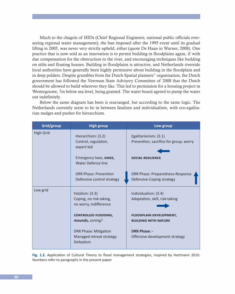
Below the same diagram has been is rearranged, but according to the same logic. The Netherlands currently seem to be in between fatalism and individualism, with eco-egalita-rian nudges and pushes for hierarchism.
Grid/group High group Low group
High GridHierarchism: (3.2)Control, regulation,expert-led
Emergency laws, dikes,Water Defence line
DRR Phase: Prevention Defensive control strategy
Egalitarianism: (3.1)Prevention, sacrifice for group, worry
social resilience
DRR Phase: Preparedness-ResponseDefensive-Coping strategy
Low gridFatalism: (3.3)Coping, no risk taking,no worry, indifference
controlled flooding, mounds, zoning?
DRR Phase: Mitigation Managed retreat strategyDefeatism
Individualism: (3.4)Adaptation, skill, risk-taking
floodplain development,building with nature
DRR Phase: - Offensive development strategy
Fig. 1.2. Application of Cultural Theory to flood management strategies, inspired by Hartmann 2010. Numbers refer to paragraphs in the present paper.
31
If no floods have occurred for a very long time, the floodplain as attractor becomes ever more alluring. Floodplains, which are prime locations for residential and commercial deve-lopments and reduce transport costs, are rediscovered as profitable investment sites for hou-sing and other human land uses, an individualist rationality.
The 2008 Delta Plan, a follow up to the 1953 plan to prepare for a climate–proof future, again had nothing to say about spatial planning: the sea may rise by up to 1.35m in the next two sentences, but Dutchmen can build wherever they want as long as the dikes and dunes keep them safe. flying in the face of apparent reason, the Dutch planned a new housing devel-opment project was planned at one of the country’s lowest spots, well below sea level in the quaint town of Gouda, just because they can. Since the lifting of the ban on building in flood-plains, zoning has become a no-no.
Should a new flood catch the Netherlands unawares, however, a new cycle is likely to start, with new incarnations of predictable social, economic and technical responses. The below gives a rundown of the latest set of what are now promoted as “best practices”.
Reviving and Surviving Best Practices
Egalitarianism: Back to Social Resilience. Cross-cutting the technological and managerial practices are the overall pattern of water governance.
In current policy folklore, we are currently moving from “government to governance”. Likewise in the Netherlands water management is held to be “traditionally” top-down. So-cial resilience and spatial adaptivity can be expected to be low in the Netherlands due to the infrastructural investment fixing rather than moving with the water.
However, a closer look at history reveals that farmers, monks and businesses have taken the lead long before the state took over a big chunk, and that public dominance in this has only recently peaked, from the 1953 flood until the early 1990s, a time when decentralisa-tion and liberalisation took hold of the Netherlands.
In addition to local and regional water managers, civil charity continued to play a pro-minent role in flood management in the period leading up to the French occupation (1798-1806). “A blend of emergency and reconstruction aid in which civil charity, central state involvement and the contribution of the Dutch kings mobilised a whole nation in times of calamitous flood disasters.” Flood relief only gradually came to be nationalised in the Netherlands between 1740 and 1861, the latter half coinciding with what Lintsen (2002). Calls the “authoritarian period” in Dutch flood management.
Since the Delta works, finalised the 1980s, the Dutch have depended on the government and technology to take care of their security. Until 1994 however, Dutch regions did not even have evacuation plans, believing floods would never happen again. After the 1995 high-water event, the Delta Law temporarily gave the public sector extra powers. In 2003 the cen-tre-right Dutch government however decided it would not be 100% responsible for floods. In 2006, and again in 2009, it called for self-reliance (zelfredzaamheid). The government would now facilitate social self-help in disaster events. Awareness campaigns remain ambig-uous and exclusively focussed on households. So-called safety regions however are re-estab-lishing contact with civil society.

32
As Virginia García Acosta (in Hoffmann and Oliver-Smith, 2002) notes, a host of natu-ral hazards like earthquakes, droughts, fires, frosts and floods can be normal events (the norm) without necessarily being disasters. She notes social, cultural, ideological, political and economic aspects are decisive as to the extent people can handle the challenge and strongly influence the ease of recovery. Likewise Graciela Peters (2010) has researched the “manageability” of disasters in the Philippines, to complement GIS expert maps which only indicate where a flood might happen. The ratio: if you want to know if and how people cope, ask them.
While civic initiative is currently rare, it is celebrated in the tale of Hans Brinkers, the little boy who stuck his finger in a dike to prevent it breaching. (Interestingly this tale is not so well known in the Netherlands itself). There are celebrated stories of ships driven into dike breaches to keep the defence from bursting. When rough weather suggested danger to the dikes, groups of trained volunteers would patrol the defences to check their security. This so-called “dike armies” spring from a sense of social obligation to contribute to collec-tive flood safety. In the past decades, along with the dissolution of the Civil Defence, dike armies also fell out of fashion. Some however survive. In the “closed season”, 1 April to 1 October, these volunteers receive training and practice sessions such as sandbagging areas. In Kampen, which sees flood risk both from the Lake and from the River Ijssel, has civic dike teams putting in small flood defences to protect riverside houses and historic buildings? It is however clear that these volunteers are only involved in an operational capacity, and not involved in decision.
Social Resilience, Local Knowledge and Religion. In the rural town of Kampen, the fis-hing community of Urk and elsewhere, orthodox Christians refuse to have a rescue package in their house, to be insured, to be inoculated against sickness, relying instead on their social and religious solidarity. This “premodern” social identity gives the lie to national prepared-ness campaigns.
Religion, historically a dominant aspect of culture in the Netherlands, has inspired both proponents and opponents of water projects. This goes back a long way. After the downfall of the Roman Empire, a Frankic influx from the east to the west of the area also brought the Christianisation of the Netherlands. They beat the Frisian kingdom, and King Radbo(u)d fled with his fleet to Denmark around 718. The Frankic occupation and Christianisation however was undone by the Vikings, who set up a protection racket as defenders of the coast around 850-880 (Evert Kramer). According to Rooijendijk (2009), when 2500 people died in the storm of 838, Frankic bishops interpreted the floods as the scourge of God. The Frisians were finally converted to Christianity.
The link between religion and disasters is a tight one. Ever since the biblical deluge, many disasters are still remembered by the name of the Christian festivity or saint’s day, from St. Elisabeth’s floods of the 15th century and the 1651 St Peter’s flood to the UK Easter floods of 1998 and the 2004 Christmas tsunami. In 1570 on All Saint’s Day, a horrendous flood struck the Dutch coast two year after the Calvinists crushed Roman Catholic icons and pul-pits in 1568 in protest to Spanish rule in the Netherlands. The flood left 20,000 dead.
33
Calvinism was a force for land reclamation in the Netherlands. Unlike Luther, Calvin was in favour of merchants, urging them not to hoard but reinvest their profits. Interestingly, the river Purmer was laid dry in 1622 backed by counter reformist investors.
Religious opposition to water policies remains today. The recent “horizontalisation”, that is, the drive for democratisation and naturalisation of water management therefore was not necessarily applauded by farmers, especially when the EU turned farmers into nature stewards. Orthodox Calvinists however frequently resisted this felt they were there to make the Earth productive. For orthodox Christians confronted by “Making Space for the River” projects such as the interventions on the river Waal at Druten, stewardship of the land means tilling it, not leaving it to nature (interview, van Vuuren, 2008).
What about the role of non-religious local knowledge and beliefs? Several older citizens in riverside areas still go by the signs of nature and the memory of earlier floods, and have repeatedly beaten the “experts” on detail. “I never heard the dikes groan but now I do”, a lady from Druten said (van Meurs, 1995). The people are not always right though: the exam-ples from interviews conducted after the 1995 high-water event by van Meurs, a critical jour-nalist, show that people’s local knowledge can be rather hit and miss.
One would expect local knowledge to be deployed to counter expert knowledge in resis-ting spatial interventions, but in cases we researched, it proved more effective and expedient not to. An interesting finding from different projects however (Warner, Roth and Winnubst, 2006; Warner, 2010) is that communities also gain access to expert knowledge to make their point. In the context of the European-funded Freude am Fluss project, the local platforms I came across in the Netherlands, Germany and France were almost invariably led by (semi-)retired professionals with a lot of time on their hands and a very good social network, through which they find counter-expertise, shooting holes in official models and reports, or fighting the numbers with other numbers (e.g. Zutphen, Ooij, Cologne, Brehemont).
Farmers meanwhile find ways of liaising with farmers elsewhere to exchange professio-nal reports and strategies.
Resuscitating Established Institution: Water Boards. Monasteries and farmers developed technologies for reclaiming3 more and more land at the end of the first Millennium A.D. Landowners gave floodable land to monks. Monks at that time were the only social group with enough time and education to study technology. This laid the foundation for the thou-sands of famed water management boards developing around the 12th and 13th century. The water boards bring together farmers to arrange for flood defence and regulate drainage. Dependence on the cooperation of everyone is believed to have fostered a fondness for con-sensus-building and tolerance of minorities. Reclamation increased the number of water boards from 2000 to 2500 between 1900 and 1950. Sometimes a single herder would build a sluice and be the director and technical service of a water board (IJff, 1993). While often presented abroad as a venerable model of democracy, the water boards were far from egali-
3 “Reclaiming” itself of course is a modernist term suggesting something needs to be claimed back from the sea
that was yours all the while.
34
tarian, as land ownership and religious affiliation were important power resources. Some are more equal than others, and farmers dominated water boards, mocked as “farmers´ re-publics” (Westerman, 2001; van Meurs, 1995). Water boards competed with each other by raising their dikes more than their neighbours, so that the latter would be flooded rather than them. The row of windmills at Kinderdijk still stand testimony to the lengths adjacent water boards would go to outdo their neighbours.
The Dutch were late to stage their industrial revolution – it did not unfurl until the 1920’s. The agrarian sector kept dominating the Dutch economic landscape until well into the 20th century.
Especially after the Second World War, farming was prioritised to achieve food security, to avert famine. Water management privileged farming, monosectorial flood and drainage policy was dominated by water boards. The post-war reconstruction was industry-based – rivers were not much more than sewers and drains. The built environment also demanded more influence in the water board.
The still valid adage for water board governance, Interest-Pay-Say (your influence is re-lated to how much you contribute, which in turn is dependent on the interest you have in dry feet) reveals the wealth-based rather than rights-based character of community-based water management in the Netherlands, although historically in-kind payment has also been acceptable. A multi-stakeholder set-up allocates specific seats to specific interests.
Farmer-dominated “water boards” still constitute a force to be reckoned with as a coun-terpoint to the central level. The Dutch water boards are often presented as “prime exam-ples of a form of community based common pool resource management” (Toonen, et al., 2004). Water boards uniquely have a constitutionally enacted role in protection of the land. They have their own powers of taxation, bypassing the political vicissitudes of national budget cycles.
Yet water boards have recently been going through a difficult patch. The attempted de-mocratisation, introducing political parties in the water board elections (November, 2008) failed spectacularly: less than 10% of the population showed up.
In the austerity frenzy currently taking hold of the Netherlands in response to economic crisis, all political parties have in their recent 2010 election platforms targeted the dissolu-tion of water boards as a way of reducing costs and administrative complexity. Toonen et al however wonder if the upscaling of the thousands of smaller water boards to 27 larger ones over the past decades did not already threaten the community base and, as a result, popular legitimacy of water boards. The technocratic rather than participatory focus, privileging new infrastructural initiatives, has not been remedied by democratising the water board elec-tion system.
Hierarchism: Dutch Defence Line (water as an ally). In the Netherlands, saying “dikes” is saying security (Buzan et al., 1998). The vulnerability to flooding has made river regulation a national security issue. The creation of the Dutch republic helped coordinate this. Dutch “water defence lines” served military purposes. A military controlled flooding defence line was used against foreign invasions, for example in 1672, when four foreign powers conspi-
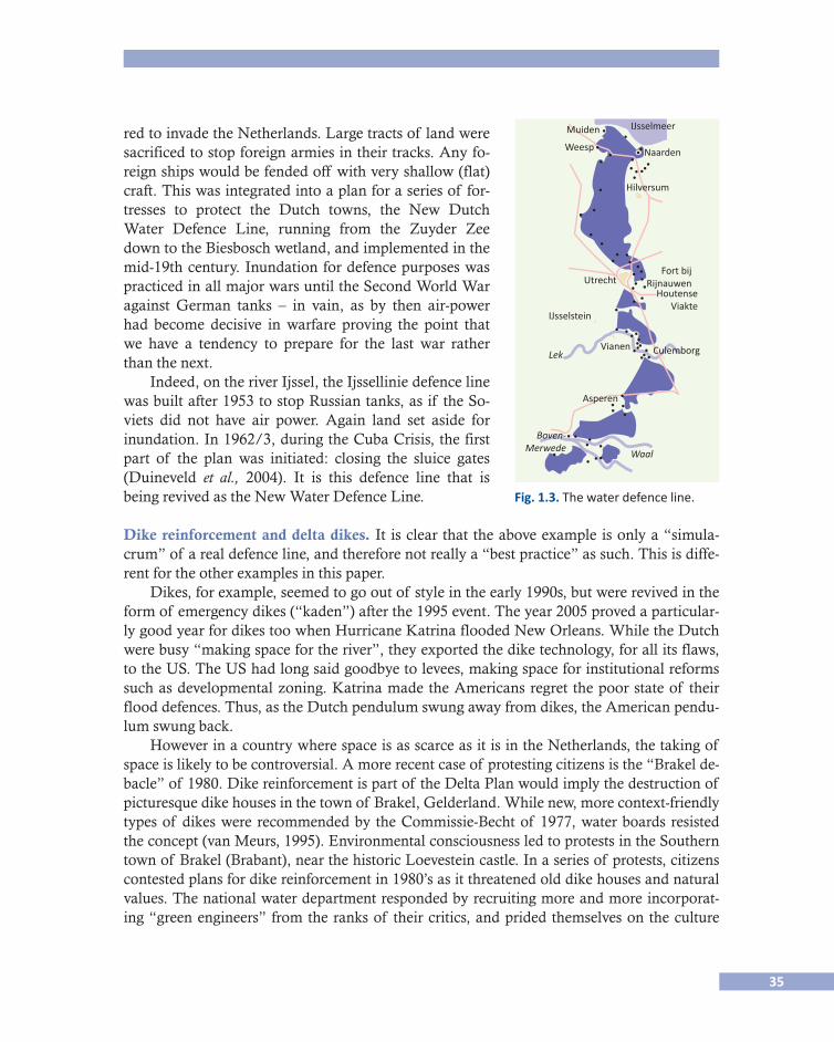
35
red to invade the Netherlands. Large tracts of land were sacrificed to stop foreign armies in their tracks. Any fo-reign ships would be fended off with very shallow (flat) craft. This was integrated into a plan for a series of for-tresses to protect the Dutch towns, the New Dutch Water Defence Line, running from the Zuyder Zee down to the Biesbosch wetland, and implemented in the mid-19th century. Inundation for defence purposes was practiced in all major wars until the Second World War against German tanks – in vain, as by then air-power had become decisive in warfare proving the point that we have a tendency to prepare for the last war rather than the next.
Indeed, on the river Ijssel, the Ijssellinie defence line was built after 1953 to stop Russian tanks, as if the So-viets did not have air power. Again land set aside for inundation. In 1962/3, during the Cuba Crisis, the first part of the plan was initiated: closing the sluice gates (Duineveld et al., 2004). It is this defence line that is being revived as the New Water Defence Line. Fig. 1.3. The water defence line.
Dike reinforcement and delta dikes. It is clear that the above example is only a “simula-crum” of a real defence line, and therefore not really a “best practice” as such. This is diffe-rent for the other examples in this paper.
Dikes, for example, seemed to go out of style in the early 1990s, but were revived in the form of emergency dikes (“kaden”) after the 1995 event. The year 2005 proved a particular-ly good year for dikes too when Hurricane Katrina flooded New Orleans. While the Dutch were busy “making space for the river”, they exported the dike technology, for all its flaws, to the US. The US had long said goodbye to levees, making space for institutional reforms such as developmental zoning. Katrina made the Americans regret the poor state of their flood defences. Thus, as the Dutch pendulum swung away from dikes, the American pendu-lum swung back.
However in a country where space is as scarce as it is in the Netherlands, the taking of space is likely to be controversial. A more recent case of protesting citizens is the “Brakel de-bacle” of 1980. Dike reinforcement is part of the Delta Plan would imply the destruction of picturesque dike houses in the town of Brakel, Gelderland. While new, more context-friendly types of dikes were recommended by the Commissie-Becht of 1977, water boards resisted the concept (van Meurs, 1995). Environmental consciousness led to protests in the Southern town of Brakel (Brabant), near the historic Loevestein castle. In a series of protests, citizens contested plans for dike reinforcement in 1980’s as it threatened old dike houses and natural values. The national water department responded by recruiting more and more incorporat-ing “green engineers” from the ranks of their critics, and prided themselves on the culture
Muiden
Weesp Naarden
Hilversum
IJsselmeer
IJsselstein
Vianen Culemborg
Asperen
Lek
Waal
Boven-Merwede
UtrechtFort bij
RijnauwenHoutense
Viakte
36
change. Thus the next state advisory commission, Boertien I, was responsive to a group of concerned ladies protesting the cutting down of trees on dikes in the river Ijssel.
The Second Delta Commission report, written and presented as if a catastrophe was im-minent, advocates multipurpose delta-dikes, which would however combine flood defence with offensive land development. In the Netherlands, modelled on the Japanese J-cans. These 300m wide unbreakable dikes might also house non-security concerns such as natural and/or agricultural spaces, high-speed trains and industrial sites. In that case, they may be more properly grouped under offensive land reclamation projects.
Fatalism: Reviving Calamity Polders - Politicised Risk While the high-water events of 1993 and 1995 led to a programme of emergency defences, they also opened a window of opportunity for “making space”. This was facilitated by the seeming sudden availability of additional space. The European Union´s Common Agriculture Policy reforms of the early 90’s stipulated agricultural land being taken out of production, which was very helpful in the greening of river management. The mountains of butter and lakes of milk had given subsidised farming a bad name. Rather than production, reduction through fallow was now to be promoted. Natural and cultural values were prioritised over far-ming, farmers (a profession dominated by over-55’s) were expected to retire and sell their land.
Draining flood water as soon as possible no longer was the preferred flood management philosophy. Rather, retaining water as long as possible before releasing it and diverting it to where it can do less harm. Space was freed up for detention basins and “living with water” solutions, from a “if you can’t beat it, join it” philosophy. For this, farmers needed to be coaxed or bought out. In the province of Zeeland, reclaimed land is returned to the water for ecological reasons. This practice of so called “depoldering” has created huge controversy in an area that suffered major human and economic losses as recent as 1953.
The more radical version of the practice is setting aside inhabited areas, however sparse, to cushion exceptional flood peaks. In 1994, the Nijmegen Mayor D’Hondt and water board chairman Kok developed an evacuation plan which would be triggered at a certain water le-vel. This however was apparently not communicated to the national water department, who disagreed with the level, but could not veto evacuation as the first residents were already fleeing the region (van Meurs, 1995). Van Meurs interviewed local residents who pointed out that the weak spot in the dike at the village of Ochten, which received much TV covera-ge, was 70 year old and had never caused problems.
In 1995, the water manager was close to springing a dike to save a more densely popula-ted area. In 1998 a northern polder (Tussenklappenpolder) was inundated to save the city of Groningen from, a storm water flood. To prevent spur-of-the-moment decision, it was deci-ded to structurally assign inhabited areas to controlled flooding.
For the Ooij citizens, however, controlled flooding begged the question: Doesn’t floo-ding one’s own citizens fly in the face of the social contract? After a slow start, citizens star-ted to resist controlled flooding of their polder with gusto from 2002 (interview with Sanders, 2005).
37
Yet controlled flooding was a time-honoured practice in the Netherlands to deal with excess water influx. “Calamity polders” were assigned in there sparsely populated eastern regions. Inhabitants were aware that they lived in “calamity polders” and would be compen-sated for their loss (Klijn and Van Der Most 200x). The plan revived ancient history in that very region – until deep into the 20th century two sluices were built which were customarily opened each year on 11 November to inundate the polder Inundation served the purpose of counter pressure against dikes to prevent dike breaches, and fertilisation through sedimenta-tion left behind by the water (Warner, Roth, Winnubst, 2006).
Ice floes would damage dikes and dike breaches occurring each year forcing people to live higher up or flee to artificial mounds.
The river changed course all the time, and upstream and downstream water boards qua-rrelled all the time (Roth et al., 2006). Engineering works reduced the size of the river and stabilised its course. In 1926 the practice of inundation stopped.
But for the Ooij citizens, the threat were also administrative – the nearby city of Nijme-gen, one of the oldest towns in the Netherlands, had set its sights on the polder as early as 1900. Repeated attempts were resisted. Nijmegen wanted to increase the bend in the river Waal to enable bigger ships to navigate the river – the Waal branch of the Rhine is the most busily transportation route in Europe. In 1995 and 1998 dike reinforcement led to protests and in 2000 the polder was designated “calamity polder statuses after a study by Haskoning exploring potential for the area as a retention area (ibid.).
Resistance took place at five levels (Warner, 2008). After the provincial authorities and Chamber of Commerce took an early lead (1), the mayor of Beek and Ubbergen carried the flame (2), a local civic platform emerged (3) in 2002 instigated by the local rabo Bank’s branch office, which lobbied national politicians (4). These four groups however would not have been co successful without the tacit support from a “fifth column” within the state apparatus, who our interviewees suggest leaked a critical report to the local platform (Froth et al., 2006). This and other reports undermined the assumptions and calculations made to underpin the rationale for the selection and designation of the polder for controlled floo-ding. The water vice minister was forced to backtrack in 2005, although it should be obser-ved that the plan was shelved, not abandoned.
As an intermediate solution, the Ooij platform accepted the compartmentalisation of the area, more in line with Van Ellen’s idea for Bangladesh in the 1990s as part of that country’s Flood Action Plan. Monsoon flood water was to be drained in a finely grained network of sluices, whose doors would be democratically opened and closed (Warner, 2010). Prof van Ellen, opposed to control flooding in his backyard, was one of the Panel of Experts. This carried an interesting irony as the Querdamm built between Ooij and Düffel in the 20th century made sure an event would only flood the Ooij - not the Düffel.
Building on Mounds. Another way of accepting floods is to build mounds while leaving the area exposed to regular flooding. This is now practiced in some “Space for the River” pilot projects. Building on mounds is in fact
38
The rivers Rhine and Meuse are thought to have crisscrossed what is now the Nether-lands for two million years (Rooijendijk, 2009). Between 3800 and 2000 B.C. the ice caps over the Netherlands melted. The first settlements were on the sandy grounds in what are now the North, East and Southeast Netherlands. Their livelihood was wheat production, cattle rising. Settlers colonised so-called mounds - little elevations in the marshes on which Germanic tribes survived, and which they gradually increased with manure, trash and a mix of clay and grass. Human occupation caused and continues to cause land loss through peat excavation for fuel and building material, causing subsidence. In so doing, the Dutch precipitated their own floods - causing lakes that eroded the land even more (so-called “wa-ter wolves”).
A celebrated experiment in the Netherlands as progressive is the Overdiepse polder, a relatively small reclaimed area in the South of the country. Farmers facing increased flood risk due to upstream interventions, were not just given the option of a buy-out enabling them to move horizontally, e.g. emigration, or vertically, elevating their farmstead on mounds, while meadows are left to be flooded on a 1 in 25 basis.
Reviving the MoundsIn the late 20th century mounds were revived in response to unanticipated high-water events of 1993 and 1995, as well as dire climate change predictions.
Recent historical policy changes have been propelled by depoliticised State Advisory Commissions. While two of these commissions were convocated after a flood event, three were instated absent a flood. The furor over climate change changed the frame engendering climate “securitisation”. (Van Buuren en Warner, 2010) and led to the instatement of yet another commission the Second Delta Commission led by ex-Agricultural Minister Veer- Veer-man in 2006.
Douglas and Wildawsky (1982) have shown that risk can suddenly become political when the stability of a system is successfully presented as being under threat from the out-side —and somewhere or something can be “blamed”. This can also happen at national lev-el— climate change has been successfully framed a threat to our survival and Dutch identity.
Arguably due to a complex operation of the evolving climate, isostatic forces and man-made subsidence the North Sea level has seen a rise of 5 to 10 cm per century since 1750 but not seen as the cause of the problems. There is as yet no evidence that sea level on the Dutch coast has been rising faster than before.
The “vertical” technique of dike building is now joined by two other time honoured “horizontal” techniques resurfacing after the 1995 floods - controlled flooding and building on mounds (“terps”) and the controlled flooding of “calamity polders”. Combinations of these practices are found in recent “Making Space for the River” interventions currently in train in the Netherlands. We will take closer look at these technologies and the controversies surrounding them in Section 3.
Jeroen Aarts of the Free University, Amsterdam has proposed to upscale this practice to national level by lifting whole regions by 5 meters. This idea made the national news, but implementation has not been very seriously considered so far.
39
Smaller initiatives for building on mounds however has proved more successful. In the polder of Overdiep, a plan was hatched, spurred by famers supposed to make space, to raise their farmsteads on mounds as an alternative (Roth and Winnubst, 2009).
NB. Another adaptive, “living with the river” technology is exemplified by DuraVer-meer’s (a building consultancy) floating houses, inspired by Asian traditions, were built at Maasbommel on the river Maas and attracted much international interest. Yet when I visit-ed them in 2007 they were pretty unsaleable and a followup seemed unlikely.
Combined Retention and Mounds: The North and South Meene Project Another example of mounds as a solution for flood risk in the East Netherlands is that of the Meene) (from Warner, et al., 2010). In 1998, heavy rainfall threatened four villages along the river Ijssel. Regional authorities prepared the area for evacuation and for cutting the dikes for controlled flooding. The cuts were only cancelled at the last minute, while evacua-tion was already in place. When the regional Farmers’ Union called a public meeting, angry residents demanded that dike cuts and evacuation would never be on the agenda again. The water authority duly promised this and decided that the Meene area was to be a retention area for regional flood safety purposes. Local residents would be protected by dikes in case the detention area was to be used in a flood. Local residents however opined the proposed dikes” locations had been planned too close to their houses, while farmers believed their in-terests had been sacrificed for the safety of downstreamers, and that they had been presen-ted with a fait accompli. The Water Board devised an alternative: Instead of diking up resi-dential areas in the retention area, buildings and roads were to be placed on small elevations (mounds) to ensure dry feet. Some residents decided to lobby the local authority who dra-gged their feet on changing the local town and country planning. To meet the European deadline, implementation would have to start without the formal planning procedure being finalised. Inhabitants drove the price up for compensation.
While this incentive helped persuade one farmer opponent to terminate his operation and offered up land, a small group was still prepared to block everything, which would not only imperil the project but in so doing also residents and land owners . The Farmers’ Union decided to reach out to the other resident stakeholders more, and came to act as a go-bet-ween (broker) between residents and the authorities. In this role they reached an agreement with the Water Board.
Why are these plans resisted? A clue is that they the new plans are externally imposed and not rooted in community experience any more. Another blue seems to be that returning land to water is more counterintuitive than building mounds. We will delve into those in the section below.
Land Reclamation and Building with Nature Currently the dumping a large amount of sand into the sea to foster land accretion due to largely predictable morphological processes. It is now also proposed as a solution for Ban-gladesh where land scarcity is chronic. This form of land reclamation, sold as “best practi-ce” may not be so new either.
40
History shows that together with dikes as defensive structures to contain flood risk, the Dutch have also taken great pains to realise offensive, expansive strategies, “reclaiming” land from the sea. In 1825, for example, a flood following a 3-day northwesterly storm with spring tide gave rise to enormous program of diking for protection and land reclamation. The islands like Urk and Schokland were minimized both through maritime action and hu-man intervention. The 19th century also saw the reclamation and damming of the Zuyder-zee, a crossroads of waterways. What are now river towns with hanseatic roots were once sea harbors, from Kampen up to Zutphen. Poldering and other forms of land reclamation earned the Netherlands a reputation for technical daring.
It is not only the “new” ideas in water management that are revived, but also the stru-ggles surrounding them. Indeed, land reclamation schemes were often protested – after all they are invasive, risky, expensive and in the first decades, completely uneconomic. For example, Dutch merchants reinvested colonial profits in risky land reclamation projects. Starting with Lake Beemster. When the protests of fisher folk, coopers, shipbuilders, naviga-tors and even soldiers were overruled, angry opponents repeatedly cut the ring dike protec-ting the project (p. 128). This set the standard for public opposition. While water works at the time were still crazy private plans, water management became a national concern with the French occupation, and public anger focused on the state. More recent societal protests against poldering concern the Markermeer in 1977, the latter inspiring among others a mu-sical anti-reclamation composition Rhapsodiques and a massive display of fishing boats from the entire region (“vlootschouw”).4
Landscape architect Adriaan Geuze (in Hulten 2005) typifies land reclamation as “an accumulation of ’ dubious engineering, louche merchants, exploitation and speculation. En-trepreneurs who saw proft in reclaiming land. But didn’t necessarily turn out to have the right technical tool box to really pump those polders dry.”
The current shift from dikes to side channels and regional development, while promp-ted by social opposition, has not silenced the protests. The switch to “Making Space for the River” however did not appease citizens. Some of those surprises are not so surpri-sing, either, as they are rooted in history and social practice overlooked by ideals of the modernist engineering and recent, maybe not so postmodern developments in Dutch water management.
Interesting in this context, Mitchell (1995) shows how modernist development narrati-ves depict an area, such as a floodplain, as failed, or otherwise uninteresting or backward, and to be badly in need of “sexing up”. In the Netherlands, rivers have long been used as drains serving economic objectives, but been rediscovered as beauty and enjoyment spots. Houses facing the river can expect to fetch much higher rents and property prices, while re-creational facilities by the water promise ready uptake. In “Space for the River”, floodplains can thus be presented as underexploited economic as well as ecological opportunities. This
4 “Vlootschouw was 25 jaar terug indrukwekkende demonstratie tegen inpoldering Markerwaard”. Edam/Vo-
lendam website: <http://edam.volendam.nl/?p=6003)>, 12 September 2004. Last consulted 2 October 2011.
41
joint development discourse5 is expressed in the concept of “spatial quality”. Areas held to be “neglected” (e.g. http://www.waalweelde.nl/?page_id=217) need a quality boost. But lo-cal people are unlikely to view their backyards are “underdeveloped and neglected”.
Resisting the Constant Gardiners - Understanding Local Politicisationof “Best Practices”According to Bruno Latour (1992) “we have never been modern” anyway. Rather than rein-vented tradition, it may makes more sense to identify a hybridization of pre-modern, mo-dern and postmodern strands in water management, as the Dutch anthropologist Van Der Werff (2004) does. Van Der Werff identifies the current (re)naturalization trend and the ideas it has triggered such as “the creation of so-called Green Rivers as retention basins and bypasses” as a postmodern trend. These ideas “both benefit from and contribute to modern state arrangements, technological innovations and economic growth, and suffer from tech-nological drawbacks, social alienation and a reductionist worldview” (Van Der Werff, 2004) In communication terms, Trude van Heems and Boukje Kothuis (2008) make similar com-ments on the very ambiguous “Nederland left met water” campaign, which suggests “living with water” is compatible with full control. This ambiguity may explain some of the pro-tests over present-day river engineering projects.
But then, the same may go for their opponents. “Premodern” community involvement now manifests itself as a mix of cooperation and conflict, with a view of reaping the bene-fits but sharply delimiting their limits. Thus, the Doorbraak, a new brook in the East Nether-lands integrating urban, rural and environmental values, was seen by rural stakeholders as facilitating urban encroachment (“urban development”) on the countryside. Rural oppo-nents successfully resisted this, and managed to convince the project initiator, the water board, to demarcate the river flow as a boundary beyond which no new development would be allowed (Warner, Lulofs and Bressers, 2010).
Van Der Werff (2004) goes some way towards explaining this phenomenon when he observes that while residents may appreciate the “postmodern” rediscovery of environmen-tal, cultural and landscape values in current modalities of river planning, they regret the loss of their pre-modern sense of social cohesion. Several interventions threaten to cut commu-nities in two, or lop off part of a community. This causes residents to emphasise, perhaps rediscover or even reinvent their community identity. Local authorities have frequently sided with their constituency, presenting the locality as victim to external meddling and a threat to the specific local landscape and culture.
The past few years have indeed seen many local responses, many obstructive, some more constructive in nature, presenting alternatives to planned Dutch river interventions crossing their backyards. In the case of the Ooij polder expounded below, for example, there was a sea-mless transition from anti-dike reinforcement protests to anti-inundation protests, with cam-paign funds being transferred from the former to the latter (interviews 2005/6, in Roth et al.).
5 A discourse is away of thinking, speaking, writing and acting reproduced in social interaction and is regulated
by a plethora of social, institutional processes, procedures, powers and forces

42
As Van Der Werff notes, the so-termed postmodern natural values are not divorced from technological and economic values. Water projects now come as a package deal accommo-dating a plurality of interests: flood safety, natural value enhancement, structural reform of agricultural development, urban regeneration, tourism, resolving traffic nodes, realising new housing. Housing development (“red”) values are needed to pay for all the “green and blue” gardening, but the housing developments do not cater to long-established residents. The houses obviously tend to be upmarket, intended to attract prosperous homebuyers to the re-gion.
Our own work (Roth, Warner and Winnubst 2006; Warner, 2008) reveals some nuances to Van Der Werff ’s trichotomy.
• First, true postmodernity as Van Der Werff identifies, would accept the uncontrollable and chaotic. Dutch river planners have read this as bringing in elements of “wild nature” —introducing Polish Konik horses and Scottish cattle, which are natural lawnmowers for a teeming natural greenness. This wilderness however is highly managed and rarely uni-versally appreciated. But we don´t want to compromise much on vital economic func-tions such as shipping, and we do not wild animals that actually bite children and die in the winter time. Dutch people appear to like their nature tidy – a safe, manicured cultural landscape, with docile cows that will not bite little kids. River planners, too, do not toler-ate all that much chaos— their vision of a “natural” river involves constant gardening (see also “cyclical rejuvenation”). Working with so little space, a bare minimum of natu-ral values and a plethora of contradictory goals, can only mean continuous tweaking.
All this tweaking seems to fly in the face of the dominant philosophy of adaptive “liv-ing with nature”. As Termeer and Meijerink (2008) note, the “from government to gov-ernance” narrative in public management suggests an abandonment of the illusion of engineerability. This modesty is however not so easy to practice for either public manag-ers or civil engineers. Governance theory such as Kooiman’s sees “governance” as mak-ing room for surprise and nonlinearity, public resistance is one of the surprises in practice water projects are indeed faced with, unanticipated by their initiators.
• Second,afocusoncommunitycohesionportraysaunitedfrontobscuringmultiplesub-identities. Most obviously, there are tensions between established and new residents. The “communities” may consist of generations of residents as well as newcomers look-ing for a quieter place to live. The tendency to combine “Making space for the river” with upmarket housing developments, which will help pay for the intervention, does not sit well with these established stakeholders. Neither the old nor the new members in the community feel very welcoming to these prospective new arrivals: “The last ones in will close the door behind them” (pers. comm., Zutphen campaigner, 2008). In Zutphen, the Ooijpolder and elsewhere, newcomers therefore seem the most active against “space for the river” interventions.
• Theabovemaysuggestthat“indigenous”,locallyrootedideasaremorelikelytosuc-ceed than those dreamt up elsewhere and “sold” to the locals. A hidden success factor in mounds vs. controlled flooding project may be that uncustomary funds and administra-
43
tive energies are available to make the Overdiepse Polder project a success – reputations are at stake. These cannot be expected to see much repetition. Another reason for suc-cess is the engagement and involvement of local stakeholders which was sadly lacking in the Ooijpolder case (Roth and Winnubst, 2009; Warner, Roth and Winnubst, 2006).
Not all water projects ignore local culture and structure. A more successful approach to realising a project to make water resurface to create extra space for stormwater was practiced in Ubbergen and Beek, a town of 10,000 souls that is part of the aforemen-tioned Ooij polder. The project Water werkt in Ubbergen. A success factor was to enlist older, well-known respected citizens as ambassadors. As the consultant related to me, a local curmudgeon-celebrity called Black Stef was won over by building on his local ce-lebrity status. (Haskoning consultant Marnis de Vriend quoted in Warner, Smits, But-terworth, Winnubst, 2006).
Provisional ConclusionsThe present article has shown traditions that are not so traditional, and current “best practi-ces” that are neither new nor necessarily “best”. The stream of innovations seems to form a pattern that quite neatly follows the cycle identified in Hartmann (2010). It has also been no-ted that an insular national approach is ill-advised, as the Netherlands are closely coupled with the international water community, both as leaders and followers in international trends.
Just like the revival of best practices is predictable, so should local opposition to the re-sulting policies or interventions be. However their enthusiasm for “new” approaches tends to make project initiators deaf and blind to foreseeable criticism, bringing needless conflict escalation and politicisation such as the Ooij project case. Opposition tends to be unantici-pated or, when it is, feared rather than welcomed in the Netherlands. Some things do chan-ge: opponents are no longer in fear of being drowned as punishment as they were in 1573, when the Spaniards tied the apostate residents of Zutphen with their backs to each other and drowned them in the river Ijssel.6 That surely is progress.
References
Berger, Peter L. and Thomas Luckmann 1991 [1966] The Social Construction of Reality. A Treatise of the Sociology of Knowledge. London etc.:
Penguin.Douglas, M. and A. Wildavsky 1982 Risk and Culture: An Essay on the Selection of Technological and Environmental Dangers,
Berkeley, University of California Press.
6 It is also noteworthy that the 80 year war between the Spaniards and the renegade Northern Netherlands en-It is also noteworthy that the 80 year war between the Spaniards and the renegade Northern Netherlands en-
joyed a 12 year intermission (ceasefire) used by Protestant factions to kill each other over predestination.
44
Duineveld, M., M. Koedoot and J. Langkeek, 2004 Constructies van beton & iemand die tegen zijn hond zegt: “vlieg”. Zes beschouwingen over de om�
gang met en de betekenis van “erfgoed” in de context van maatschappelijke processen, landschap & ruimtelijke ordening. Wageningen Unversity, Chairgroup Spatial Analysis, 101 pp. Online: <http://edepot.wur.nl/40347> (last consulted 2 October 2011).
García Acosta, Virginia [2002] “Historical Disaster Research”. In Hoffman, Susanna M.,Oliver-Smith, Anthony, Eds.
Catastrophe and Culture. The Anthropology of Disaster, School of American Research Press, Santa Fe, pp. 49-66.
Hartmann, T.H. 2010 Reframing Polyrational Floodplains - Land Policy for Large Areas for Temporary
Emergency Retention. Nature & Culture 5(1). 15-30.Heems Van, T. and B. Kothuis 2008 Discoursen en waterveiligheid: Waarom leiden publiekscampagnes niet tot waterbe-
wustzijn en waterbewust gedrag? Beleid en Maatschappij, vol. 35, núm. 3, pp. 190-207.Hemert, M. Van 1999 “Ruimte voor de ingenieur. Rivierbeheer in Nederland eind jaren negentig”, K&M, Ti�
jdschrift voor empirische filosofie, vol. 23, núm. 4, pp. 361-387.Holling, C.S. 1978 Adaptive environmental assessment and management. New York, John Wiley & Sons.Immink, I. 2008 “Established and recent policy arrangements for river management in The Nether-
lands: an analysis of discourses”. In: Tress, B.; Tres, G.; Fry, G.; Opdam, P. (Eds.) From Landscape Research to Landscape Planning, Springer. Ch. 28, 387-404. On line: <http://library.wur.nl/ojs/index.php/frontis/article/viewFile/1134/705>, (consult-ed 2 October 2011).
Ijff, J., 1993 “Omwentelingen in het waterschapsbestel 1968-1993”. In T. Toonen (ed.), Waterschap�
pen in Nederland: een bestuurskundige verkenning van de institutionele benadering. ontwikkel�ing. Hilversum, NL: Verlorem pp. 13-23.
Kooiman, J. 2003 Governing as Governance, London, Sage.Lintsen, H. 2002 “Two centuries of central water management in the Netherlands”. In Technology and
Culture, 43 (3) 549-568.Rooijendijk, C. 2009 Waterwolven. Een geschiedenis van stormvloeden, dijkenbouwers en droogmakers.Roth, D. and J. Warner, 2007 “Flood risk, uncertainty and changing river protection on the Netherlands: the Case of
Calamity Polders”. Tijdschrift voor Sociale en Economische Geografie, vol. 98, núm. 4, pp. 519-525.
45
Roth, D., J. Warner and M. Winnubst 2006 Een noodverband tegen hoogwater. Waterkennis, beleid en politiek rond noodoverloopgebieden,
Boundaries of Space Series, Wageningen: Wageningen University.Termeer, K. and S. Meijerink 2008 Klimaatbestendig of klimaatneutraal bestuur? Een essay overhet adaptief vermogen
van instituties, Den Haag: Raad voor Verkeer en Waterstaat.Toonen, T.A.J., G.S.A. Dijkstra and F. Van Der Meer 2004 The intergovernmental dimension of multi-commons management Modernisation
and Reform of Dutch Waterboards: Resilience or Change? Paper prepared for WOW3: The Third Pentannual Workshop “Building Social Capital and Self-Governing Capa-bilities in Diverse Societies”, Conference, Workshop in Political Theory and Poli-cy Analysis, Indiana University, Bloomington, June 2-6, <http://www.indiana.edu/~wow3/papers/wow3_toonen.pdf>.
Van Der Brugge, R. and J. Rotmans 2007 “Towards Transition Management of European Water Resources”, en Journal Water
Resource Management, Special issue: Advances in Global Change Research, <http://publishing.eur.nl/ir/darenet/asset/8047/DRIFT-2006-008.pdf>.
Van Der Werff, P.E. 2004 Stakeholder responses to future flood management ideas in the Rhine River Basin: na-
ture or neighbour in Hell’s Angle. Reg Environ Change 4:145-158.Van Meurs, R. 1995 Hoog water: de macht van de boerenrepublieken in het rivierengebied, Uitgeverij Contact.Verweij, M. and M. Thompson 2006 Clumsy solutions for a complex world � governance, politics and plural perceptions. Hampshire
and New York: Palgrave Macmillan.Warner, J. 2008 “Emergency flood storage in the Ooij Polder - a bridge too far? forms of participation
in flood preparedness policy”. International Journal of Water Resources Development, Spe-cial Issue on Water Governance. 24(4): 567-582.
Warner, J., M. Winnubst and D. Roth 2006 “Plus d’espace pour le fleuve, plus de place pour la participation citoyenne?” in Deshi�
ma Journal of Netherlands Studies, núm. 2, pp. 61-76.Warner, J., S. Smits, M. Winnubst and J. Butterworth 2006 “Local governance in Integrated Water Resources Management in the Netherlands”,
Delft, the Netherlands, LoGo Water project, Working Paper. Url <http://www.iclei-europe.org/index.php?id=1547>.
Wesselink, A.J. 2007 Flood safety in the Netherlands: The Dutch response to Hurricane Katrina. Technology
in Society 29 (2), pp. 239-247.Westerman, F. 2001 De graanrepubliek. Atlas.
46
Wiering, M. and B. Arts 2007 Discursive shifts in Dutch river management: deep institutional change or adaptation
strategy? In R. Leuven, A. Ragas, A. Smits & G. Velde (Eds.), Living Rivers: Trends and Challenges in Science and Management (Vol. 187, pp. 327-338): Springer Netherlands.
Contact Jeroen Warner, Wageningen University, Netherlands: <[email protected]>.
47
2 Measuring the Vulnerability and Resilience to Hydrogeological Risks: Results and Applications
of the Ensure EU Funded Project.
Scira Menoni, Politecnico di Milano, Italy
ResumenEl proyecto Ensure financiado dentro del 7º Programa Marco tiene dos objetivos principa-les: mientras que por una parte busca y explora el estado del arte en términos de vulnerabili-dad y resiliencia, por otra desarrolla un marco conceptual integrado para evaluar la vulnerabilidad y la resiliencia en determinado contexto. El estado del arte se ha aplicado y desarrollado dentro del marco conceptual en términos de indicadores y parámetros tanto cuantitativos como cualitativos con la finalidad de proporcionar una herramienta pública a los administradores, consultores y comunidades con deseos de evaluar la respuesta, resisten-cia y capacidad de reajuste de una determinada área, ciudad, población. En particular, un grupo de cuatro matrices, dirigidas hacia las diferentes escalas de tiempo de la mitigación antes del impacto, la emergencia y la recuperación para amenazas hidrogeológicas, inunda-ciones y deslaves. Como logro final del proyecto, se ha aplicado metodología y matrices a casos de estudio en particular.
AbstractThe Ensure project funded within the VII FP had two main objectives: on the one hand to search and explore the state of the art in terms of vulnerability and resilience, on the other to develop an integrated framework for assessing vulnerability and resilience in a given con-text. Within the framework the state of the art in terms of indicators and parameters both quantitative and qualitative has been applied and further developed to provide a tool for public administrators, consultants and communities wishing to assess the response, resis-tance and coping capacity of a given area, a given city, a given settlement to a variety of stresses. In particular a set of four matrices, addressing the different time scales of mitiga-tion before the impact, impact, emergency and recovery have been developed for hydrogeo-logical threats, floods and landslides. As a final accomplishment of the project, the methodology and the matrices have been applied to specific case studies.
Hypothesis/ObjectiveEnsure (Enhancing resilience of communities and territories facing natural and na-tech haz-ards, CN. 212045) is a project funded byt the EU Commission under the VII FP. It was aimed at creating an integrated framework for assessing vulnerability to multiple risks. The main idea behind the project was that while theoretical clarification of the vulnerability con-cept is important, as well as clarify differences and similarities with other terms like coping capacity, adaptation, resilience, there is a strong need for tools that may be used in mitiga-tion projects. In other words, understanding the relationships among aspects and elements,
48
improve the conceptualization of the risk equation is not enough: the fundamental question of how such scientific enhancement can help in reducing and preventing the potential dam-ages provoked by natural hazards must be answered as well.
Context and ProblemClearly whenever a risk assessment or as in this case a vulnerability and resilience assess-ment tool is proposed it offers the flank to criticism, as what is actually known about the re-sponse of systems and communities must be made explicit and sometimes the paucity is really striking, especially if it is compared to the relatively sophisticated modeling and moni-toring systems that are available for analyzing the hazard component of the risk equation. Yet, there is an increasing understanding also within the scientific community that has a long tradition with hazard analysis, that without a much stronger intervention on the vul-nerability of exposed regions and systems, both the human and the economic losses will not be reduced. Actually what is experienced is a still very large death toll in developing coun-tries due to a variety of threats, and a significantly increasing economic damage in both de-veloping and developed countries.
From a methodological point of view, the project is divided in two parts: first the “state of the art” in understanding vulnerability has been searched, then the proposal part has been developed. With respect to the first step, perhaps the most interesting achievements derived from the second work package, devoted to explore the relationships among differ-ent types of vulnerability. In general terms, within the Ensure project, vulnerability is de-fined broadly as the propensity to damage, while damage is the expected result of the combination of a given hazard’s severity and the vulnerability of exposed systems (includ-ing the social one). It is very limiting though to consider such fragility only in physical terms. Other forms of vulnerabilities have been elicited by research in the past years, refer-ring to economic and social features that make a given society stronger or weaker in cop-ing with the threat and with its potential impact, as well as to the so called “systemic” vulnerability, referring to the resources that do or do not exist to face not just the impact as the consequences it produces across multiple systems. With the increasing complexity of human settlements, the systemic vulnerability component has gained a prominent role in defining the final level of damage and disruption a disaster may cause. More than the physical damage, the loss of functionality of basic utilities, such as lifelines, the incapacity to guarantee service of hospitals, post offices, banks, hampers both relief and rehabilita-tion efforts, not to mention the constraints to the productive sector. Vulnerability to losses has to be considered today as relevant as vulnerability to the stress itself: the latter deter-mines the extent of physical damage, while the first is responsible for induced, indirect and secondary damage.
Until now, those types of vulnerabilities have been addressed separately, by different disciplines: within the second work package the links among them have been explored using a variety of case studies as an illustration of the several connections, from the more to the least obvious that have to be better understood should the goal of reducing vulnerability in modern society be achieved. It is not enough to strengthen structures and infrastructures to
49
achieve a more resistant community: many times the indirect damage and loss of function can be provoked by a relatively small physical damage but propagate in an unexpected man-ner due to ripple effects across systems. How different types of vulnerability are connected is as important as addressing them separately: for example, physical vulnerability of buildings has its explanation in weak institutions, unable to enforce building codes and regulations even in countries where the latter exist.
What Has Been Done?Following the temporal development of the project research, the third work package ex-plored the temporal and spatial dimensions of vulnerability. As for the spatial one, scales have been identified as a key aspect, distinguishing between the hazard and the vulnerability scale, that may not necessarily coincide, In fact, the sometimes divorcing scales of the two are responsible for the weak integration between the “hard” sciences studying the intensity and severity of hazards on the one hand and social sciences looking for the dynamics that make a given community prone to suffer damage from the same hazard. As for the temporal dimension, it has been clearly recognized that as it is limiting to consider only the physical vulnerability, similarly the latter cannot be evaluated having as a time reference only the im-pact of an extreme event. Vulnerabilities develop before the latter, they are entrenched in the history of a place and of a society; they may transform into vulnerability to losses as a con-sequence of ripple effects; they may be reinforced instead of reduced in the time of recovery and reconstruction. When spatial and temporal scales come into play, the vulnerability con-cept shows its own limits: it is hard to use such concept to address the long term dynamics leading to social, economic, and territorial features that prove to be well or poorly adapted to an hazardous environment.
In this respect, according to a wide literature developing in a significant way in the last decade, resilience seems to best capture the capacity of communities and territories to re-cover successfully from a disaster, learning from the mistakes that proved to be fatal and leading to a variety of losses, reconstructing in a way that improves the prior conditions, in terms of better quality of life and reduced vulnerabilities. In the meantime, the time before an impact occurs, resilience can be understood as the capacity to mitigate, to prevent, recog-nizing first and second attempting to reduce identified weaknesses.
The second part of the Ensure project, proposes a framework to assess vulnerability and resilience across different temporal and spatial scales, acknowledging the different domains where the latter may manifest, and in particular in the natural and the built environment, al-locating a large importance to the so called “critical infrastructures”, in social and economic systems. A set of four matrices has been developed to identify what aspects should be looked at before the impact, that is to say what shows the potential ability or inability to cope with an extreme; at the impact, addressing in particular the capacity (or incapacity) to sustain various types of stresses (in the form of acceleration, pressure, heat…); in the time immedi-ately after the impact, as the ability (or inability) to suffer losses and still continue function-ing; and in the longer term of recovery, as the capacity to find a new state of equilibrium in which the fragilities manifested during and after the impact are addressed.
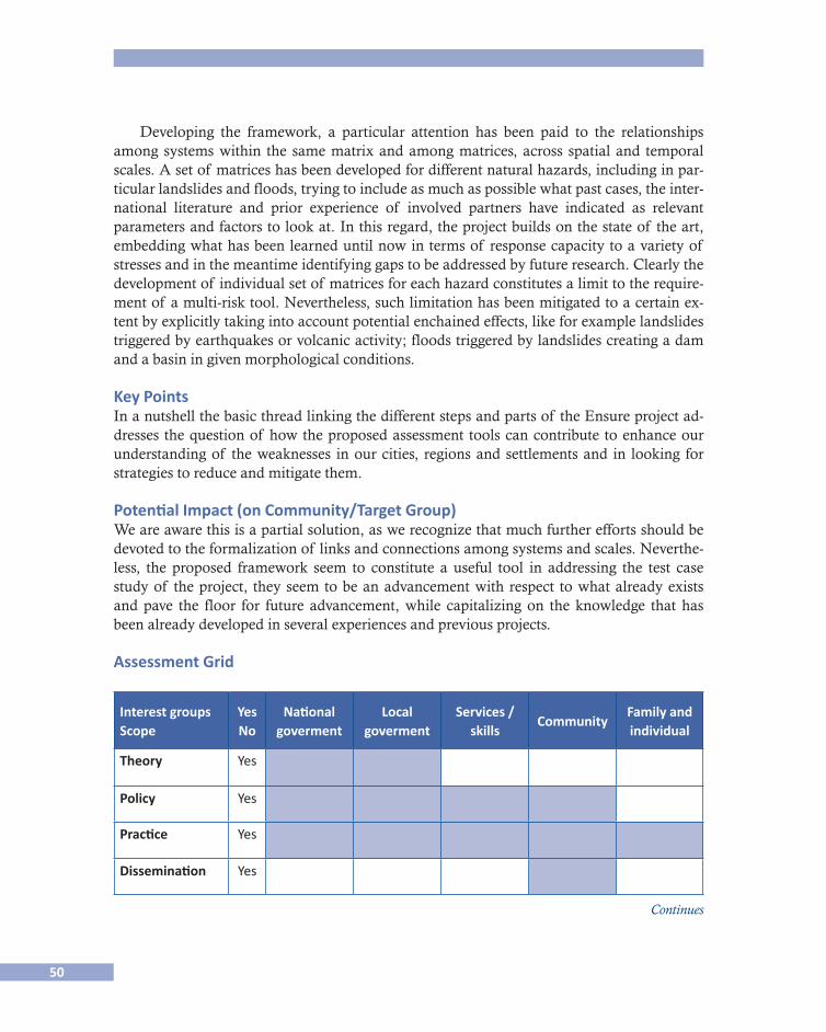
50
Developing the framework, a particular attention has been paid to the relationships among systems within the same matrix and among matrices, across spatial and temporal scales. A set of matrices has been developed for different natural hazards, including in par-ticular landslides and floods, trying to include as much as possible what past cases, the inter-national literature and prior experience of involved partners have indicated as relevant parameters and factors to look at. In this regard, the project builds on the state of the art, embedding what has been learned until now in terms of response capacity to a variety of stresses and in the meantime identifying gaps to be addressed by future research. Clearly the development of individual set of matrices for each hazard constitutes a limit to the require-ment of a multi-risk tool. Nevertheless, such limitation has been mitigated to a certain ex-tent by explicitly taking into account potential enchained effects, like for example landslides triggered by earthquakes or volcanic activity; floods triggered by landslides creating a dam and a basin in given morphological conditions.
Key PointsIn a nutshell the basic thread linking the different steps and parts of the Ensure project ad-dresses the question of how the proposed assessment tools can contribute to enhance our understanding of the weaknesses in our cities, regions and settlements and in looking for strategies to reduce and mitigate them.
Potential Impact (on Community/Target Group)We are aware this is a partial solution, as we recognize that much further efforts should be devoted to the formalization of links and connections among systems and scales. Neverthe-less, the proposed framework seem to constitute a useful tool in addressing the test case study of the project, they seem to be an advancement with respect to what already exists and pave the floor for future advancement, while capitalizing on the knowledge that has been already developed in several experiences and previous projects.
Assessment Grid
Interest groupsScope
YesNo
Nationalgoverment
Localgoverment
Services /skills
CommunityFamily andindividual
Theory Yes
Policy Yes
Practice Yes
Dissemination Yes
Continues

51
Interest groupsScope
YesNo
Nationalgoverment
Localgoverment
Services /skills
CommunityFamily andindividual
1. Shared responsability (governance)
Yes
2. Knowledge
3. Information exchange
Continue
Fig. 2.1. Framework developed within the Ensure project.
Mitigationcapacity
reconstructionemergency recoveryimpact
Time
Scale (at which vulnerabilities are considered)
Scale (of hazards)
Regional
Multi-site
Local
Macro (regional, national, global)
Meso
MicroPhysical
vulnerability:vulnerability
to stress
Sistemicvulnerability:vulnerability
to losses
Resilience:Capacity
to transformlosses into
opportunities
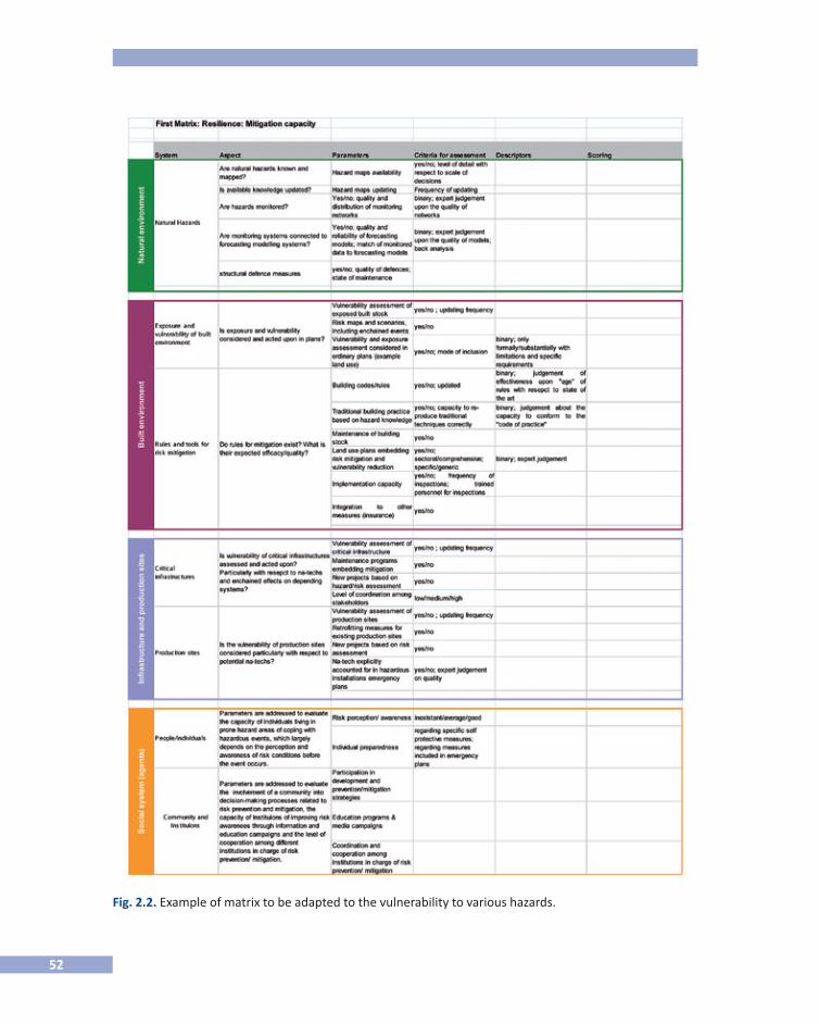
52
Fig. 2.2. Example of matrix to be adapted to the vulnerability to various hazards.

53
References
Adger, N., et al. 2004 New indicators of vulnerability and adaptive capacity, Tyndall Centre for Climate Change Re-
search, Technical Paper, no. 7.Al-Kuwaiti M., N. Kyriakopoulos and S. Hussein 2006 “Network dependability, fault-tolerance, reliability, survivability: a framework for
comprative analysis”, in Proc. The 2006 International Conference on Computer Engineering and Systems (ICCES’86), November, Cairo, Egypt, pp. 5-7.
Bell S. and S. Morse 2008 Sustainability Indicators: Measuring the Immeasurable?, Earthscan.Bruneau, M., et al. 2003 “A framework to quantitatively assess and enhance the seismic resilience of communi-2003 “A framework to quantitatively assess and enhance the seismic resilience of communi- “A framework to quantitatively assess and enhance the seismic resilience of communi-“A framework to quantitatively assess and enhance the seismic resilience of communi-
ties”, in Earthquake Spectra, vol. 19, núm. 4, pp.733-752.
Fig. 2.3. Relations among indicators across the set of matrice.
Vulnerabilityof social systems/
agents
Vulnerabilitycriticalfacilities
Vulnerabilityof the built
environment
Naturalenvironmentvulnerability
Vulnerabilityof social systems/
agents
Vulnerabilitycriticalfacilities
Vulnerabilityof the built
environment
Naturalenvironmentvulnerability
Vulnerabilityof social systems/
agents
Vulnerabilitycriticalfacilities
Vulnerabilityof the built
environment
Naturalenvironmentvulnerability
Vulnerabilityof social systems/
agents
Vulnerabilitycriticalfacilities
Vulnerabilityof the built
environment
Naturalenvironmentvulnerability
Mitigationcapacity
Physicalvulnerability
Systemicvulnerability
Resilience
54
Cutter S. J. Mitchell and M. Scott 2000 “Revealing the vulnerability of people and places: a case study of Georgetown County,
South Carolina”, in Annals of the Amercian Geographers, vol. 90, núm. 4.Cutter, S., et al. 2008 “A place-based model for understanding community resilience to natural disasters”, in
Global Environmental Change, vol. 18, pp. 598-606. Eriksen S. and P. Kelly 2007 “Developing credible vulnerability indicators for climate adaptation policy assess-
ment”, in Mitigation and Adaptation Strategies for Global Change, vol. 12, pp. 495-524.Jasanoff, S. 1990 The Fifth Branch: Science Advisers as Policymaker, Cambridge, Mass., Harvard University Press.Handmer J. and S. Dovers 1996 “A typology of resilience: rethinking institutions for sustainable development”, in In�
dustrial and Environmental Crisis Quarterly, vol. 9, núm. 4, pp. 482-511.Handmer, J. 2003 “We are all vulnerable”, in Australian Journal of Emergency Management, vol. 18, núm.
3, August.Hills, A. 2005 “Insidious environments: creeping dependencies and urban vulnerabilities”, in Journal
of Contingencies and Crisis Management, vol. 13, núm. 1.Klein, R., R. Nicholls and F. Thomalla 2005 Resilience to natural hazards: how useful is this concept?, in “Environemntal Hazards”, vol.
5, pp. 35-45.Lewis, J. 1999 Development in disaster�prone places, studies of vulnerability, uk, Intermediate Technology
Publications.Maclaren, V. 1996 “Urban sustainability reporting”, in Journal of the American Planning Association, Spring,
pp. 184-202.Menoni, S. and C. Margottini, (eds.) 1996 Forthcoming inside risk: a strategy for sustainable risk mitigation, Springer.Norris, F., et al. 2008 “Community resilience as a metaphor, theory, set of capacities, and strategy for disas-
ter readiness”, in Americal Journal of Community Psychology, vol. 41.Polsky C., R. Neff and B. Yarnal 2007 “Building comparable global change vulnerability assessments: the vulnerability scop-
ing diagram”, in Global Environmetnal Change, vol. 17, pp. 472-485.Rose A. 2004 “Defining and measuring economic resilience to disasters”, in Disaster Prevention and
Management, vol. 13, núm. 4, pp. 307-314.
55
Salter, L., et al. 1988 “Mandated science. science and scientists in the making of standars”, Dordrecht-Boston-Lon-
don, Kluwer Academic Publishers.Schuëller G., M. Shinozouka and J.T. Yao 1993 “Structural safety and reliability”, in Proc. Of Icossar”93� the 6th International Conference
on Structural Safety and Reliability, August, Inssbruck, Austria, pp. 9-13.Turner B.L., et al. 2003 “A framework for vulnerability analysis in sustainability science,” in PNAS, vol. 100,
núm. 14, pp. 8074-8079. See <www.pnas.org>.Weichelsgartner J. and M. Obersteiner 2002 “Knowing sufficient and applying more: challenges in hazard management”, Environ�
mental Hazards, vol. 4, pp. 73-77.Winograd, M. 2007 “Sustainability and vunerability indicators for decision making: lessons learned from
Honduras”, in Sustainable Development, vol. 10, no. 1/2.Winograd M. and A. Farrow n. d. “Sustainable development indicators for decision making: concepts, methods, defini-
tion and use”, in Encyclopedia of Life Supporting Systems (EOLSS), n.d., available at <http://www.eolss.net/ebooks/Sample%20Chapters/C13/E1-46B-02.pdf>.
Contact Scira Menoni , DIAP- Politecnico di Milano, Italy: <[email protected]>.

57
3 Impacts of Climate Change on Hydrology in Finland, Adaptation Possibilities
by Lake Regulation
Juho Jakkila, Noora Veijalainen, Bertel Vehviläinen & Teemu Nurmi, Finnish Environment Institute, Finland
ResumenSe espera que el cambio climático incremente las temperaturas medias anuales entre 3 y 7º C y las tasas de precipitación entre 13 y 26% para fines del siglo xxi. Esto cambiará la esta-cionalidad, la magnitud de las inundaciones así como la escorrentía a los lagos y rutas de los ríos. En el presente estudio, las posibilidades para adaptarse a estos cambios por medio del ajuste en las prácticas de reglamentación en los lagos regulados se analizan tomando en consideración la protección contra inundaciones y el uso recreativo de los lagos.
El presente estudio se enfoca en las posibilidades de adaptación en los lagos regulados en los que se espera que el nivel del agua por encima de lo normal o el desfogue de ríos aba-jo incrementen en las amenazas de riesgo a la inundación. Este estudio presenta tres lugares distintos con posibilidades variables de adaptación. En algunos casos, el alto riesgo a ame-nazas de inundación se puede disminuir por medio de la reforma de las prácticas de regula-ción. En el río Oulujoki, ubicado al centro de Finlandia, el incremento esperado en la magnitud de 100 años de inundaciones para mitad del siglo xxi puede disminuir entre 5 a 35% y 0 a 10% por medio de la reforma a la regulación. En la ciudad de Pori, la ciudad más vulnerable a amenazas de inundación en Finlandia, el alto riesgo puede disminuir hasta cierto grado, pero la prevención de inundaciones extremas de invierno será más desafiante en el futuro en comparación con las condiciones climáticas actuales. En el lago Saimaa, el lago más grande en Finlandia, se espera que las inundaciones de invierno aumenten nota-blemente cuando las posibilidades de adaptación son limitadas. Se espera que el riesgo cal-culado de inundación en el lago Saimaa llegue a ser dos veces más alto por un periodo de cada 30 años durante el siglo xxi.
AbstractClimate change is estimated to increase the annual mean temperatures by 3-7 ºC and precipi-tation rates by 13-26 % in Finland by the end of the 21st century. This will change the season-ality and the magnitude of floods and runoff to the lakes and river routes. In present study the possibilities to adapt to these changes by adjusting current regulation practices in regulated lakes are estimated by taking into account the flood protection and the lake recreational use.
The present study focuses on the adaptation possibilities in the regulated lakes in which the increased lake water level and/or the discharge in downstream rivers are predicted to in-crease the risk of flood hazards. The study presents three different sites with variable adapta-tion possibilities. In some cases the increased risk to the flood hazards can be decreased by altering the regulation practices. In River Oulujoki, located in Central Finland, the estimated
58
increase in the magnitude of 100-year floods by the middle of 21st century can be decreased from 5-35 % to 0-10 % by altering the lake regulation. In city of Pori, which is the most vulner-able city in Finland to flood hazards, the increased risk can be decreased to some extent, but prevention of the extreme winter floods will be more challenging in the future than in the cur-rent climate conditions. In Lake Saimaa, the largest lake in Finland, the winter floods are esti-mated to increase remarkably and the adaptation possibilities are limited. The estimated flood risk in Lake Saimaa is predicted to become double times higher in every 30 year period during the 21st century.
BackgroundAccording to climate scenarios the projected annual mean temperature is predicted to in-crease 3-7 ºC and precipitation 13-26 % in Finland by the end of the 21st century. This will change the seasonality and the magnitude of floods and runoff. In present study the possi-bilities to adapt to these changes by adjusting current regulation practices in regulated lakes are estimated by taking into account the hydropower productivity, flood protection and lake recreational use.
The changes in the magnitude of floods depend on the climate and hydrological condi-tions of the studied catchment areas. The recent studies (e.g. Veijalainen et al., 2010a) show that the magnitude of the snowmelt floods, especially in Southern and Central part of Fin-land, are predicted to decrease due to shortening snow season and decreased snow accumu-lation in winter. As a result the largest floods are predicted to decrease in spring flood dominated areas. On contrary the areas, where the largest floods in present climate occur in autumn and winter, are most likely to experience larger floods in the future. These areas in-clude particularly the large central lakes in the watersheds with high lake percentage and some of the small rivers in the coastal areas.
Study SitesThe adaptation possibilities are evaluated in three sites, in which the climate change is pre-dicted to increase the risk of flood hazards. In current climate conditions the major flood risks in River Oulujoki and River Kokemäenjoki are met in winter due to possible frazil ice dam formation. In Lake Saimaa the typical pattern of annual water level variation is pre-dicted to change. In the future the volume floods will occur mainly in winter, whereas the summer floods were more common in 20th century (Veijalainen et al., 2010b).
The City of Oulu is located on the shore of Bothnian Bay in the mouth of River Oulu-joki. The catchment area of the watershed is 22 840 km2 and lake percentage 11.50 %. The runoff is dominated by snowmelt in spring, but the largest discharges in River Oulujoki are observed in autumn because of the regulation of the upstream lakes.
The City of Pori is one of the most vulnerable cities for flood hazards in Finland. It is located in the mouth of River Kokemäenjoki on the shore of Baltic Sea. The largest flood in reference period (1971-2000) happened in winter 1974-75, when the frazil ice dam raised the water level and caused damages in the city center.
59
The Lake Saimaa is the largest lake in Finland with catchment area of 68 500 km2. As of the previous sites, the catchment is characterized by high lake percentage, 19.80 %. The lake is used mainly in recreational purposes with 25 000 real estates by the shores of the lake. The downstream river of Lake Saimaa flows over Russian border to the Lake Ladoga.
MethodsThe hydrological simulations are performed with the Watershed Simulation and Forecast-ing System (wsfs), which is based on a conceptual hydrological model and is used for wa-tershed forecasting and research purposes in Finland (Vehviläinen et al., 2005). The observed temperature and precipitation are used as input variables of the model in the reference peri-od. In the future hydrological scenarios the monthly mean changes calculated from global and regional climate scenarios are added to the observed inputs.
In the reference period simulations (1971-2000), the current regulation rules and practices are followed as well as possible. In the future simulations (2010-39, 2040-2069 and 2070-99) the regulation tables of the hydrological model are adjusted to diminish the negative conse-quences of the changed hydrological conditions. The proposed adaptive regulation scenarios are optimized to decrease the increasing flood risks by taking into account the consequences to hydropower productivity and lake recreational use.
Adaptation PossibilitiesIn River Oulujoki and River Kokemäenjoki the winter flood risks with possible frazil ice dam formation will increase in the future due to increased autumn and winter precipitation and later onset of winter. The adaptation possibilities in River Oulujoki are promising due to high storage capacity in the upstream Lake Oulujärvi. The estimated increase of the flood discharges can be reduced from 5 - 35 % to 0 - 10 % by altering the regulation of Lake Oulu-järvi. In River Kokemäenjoki the increased flood risk can be reduced to some extent by short-term lake regulation, but the largest floods will still cause problems in the city of Pori. The other adaption possibilities, e.g. construction planning, building higher terraces and use of the ice booms for the prevention of the frazil ice dam formation are required.
In Lake Saimaa the adaptation possibilities by lake regulation are limited. According to agreement with Russian authorities the discharge of the lake is required to follow the natu-ral rating curve, if the water level is within ±50 cm from the long-term daily average level. If the water level exceeds this limit, the outflow is allowed to increase in order to avoid possi-ble damages. However, also the increased discharges may cause damages in Russian site of the downstream River Vuoksi and therefore the possibilities to decrease the highest water levels are limited (Veijalainen et al., 2010b). The other adaptation possibilities are the con-struction planning and innovative building solutions by taking into account the predicted increase in the highest water levels induced by the climate change.
Negative and Positive Effects of Climate ChangeThe most important impacts of climate change and the adaptation possibilities are summa-rized in the tables below. In the study sites the flood risks will increase especially in winter and
60
the possible formation of the frazil ice dams may increase the flood risks in River Oulujoki and River Kokemäenjoki. The main adaptation possibilities to the winter flood hazards are the short-term lake regulation, construction planning by taking into account the increased flood risks caused by climate change, building higher terraces on the river banks and differ-ent ways for preventing the frazil ice dam formation. In Lake Saimaa the adaptation possi-bilities are limited and the predicted increase in the highest water levels should be taken into account in the construction planning. In addition to increased risk of flood hazards, the lowest water levels in summer may decrease in some lakes of the study areas, which may re-strict the recreational use of the lakes.
The estimated increase in precipitation and runoff will be mainly beneficial for hydro-power productivity, but may also increase the spillages in hydropower plants. The losses in production can be diminished by new investments in the hydropower stations.
One of the most important negative impacts of the climate change in Finland is the de-teriorating viability of Saimaa ringed seal, the most famous endangered species in Finland. The ringed seals build their nests in the snow cover on the lake ice. Due to shortening ice season the seals will have difficulties to find places for nests in the future. The possible solu-tions could be man-made nests or collecting snow to certain points on the ice to help seals to find places for nesting. Also increased water level variation during the nesting period may cause more damages in the nests in the future.
The possible solutions could be man-made nests or collecting snow to certain points on the ice to help seals to find places for nesting. Also increased water level variation during the nesting period may cause more damages in the nests in the future.
The positive impacts of climate change in the study sites includes more convenient water levels for summertime recreational purposes, which may increase the use of the lakes; swim-ming, fishing, sailing, boating, kayaking, etc. Also due to increased runoff in winter, the neces-sity to drawdown the water levels in regulated lakes will decrease. This may improve the state of the littoral zone of the lake and breeding possibilities of autumn spawning fishes.
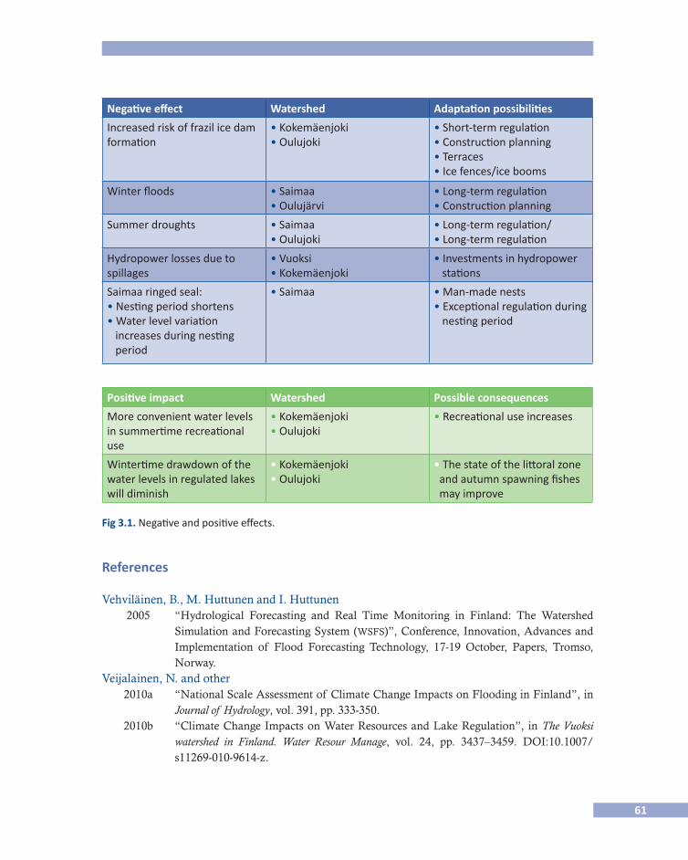
61
Negative effect Watershed Adaptation possibilities
Increased risk of frazil ice dam formation
• Kokemäenjoki• Oulujoki
• Short-term regulation • Construction planning • Terraces • Ice fences/ice booms
Winter floods • Saimaa• Oulujärvi
• Long-term regulation • Construction planning
Summer droughts • Saimaa• Oulujoki
• Long-term regulation/• Long-term regulation
Hydropower losses due to spillages
• Vuoksi• Kokemäenjoki
• Investments in hydropower stations
Saimaa ringed seal: • Nesting period shortens • Water level variation increases during nesting period
• Saimaa • Man-made nests • Exceptional regulation during nesting period
Positive impact Watershed Possible consequences
More convenient water levels in summertime recreational use
• Kokemäenjoki• Oulujoki
• Recreational use increases
Wintertime drawdown of the water levels in regulated lakes will diminish
• Kokemäenjoki • Oulujoki
• The state of the littoral zone and autumn spawning fishes may improve
References
Vehviläinen, B., M. Huttunen and I. Huttunen 2005 “Hydrological Forecasting and Real Time Monitoring in Finland: The Watershed
Simulation and Forecasting System (wsfs)”, Conference, Innovation, Advances and Implementation of Flood Forecasting Technology, 17-19 October, Papers, Tromso, Norway.
Veijalainen, N. and other 2010a “National Scale Assessment of Climate Change Impacts on Flooding in Finland”, in
Journal of Hydrology, vol. 391, pp. 333-350. 2010b “Climate Change Impacts on Water Resources and Lake Regulation”, in The Vuoksi
watershed in Finland. Water Resour Manage, vol. 24, pp. 3437–3459. DOI:10.1007/s11269-010-9614-z.
Fig 3.1. Negative and positive effects.
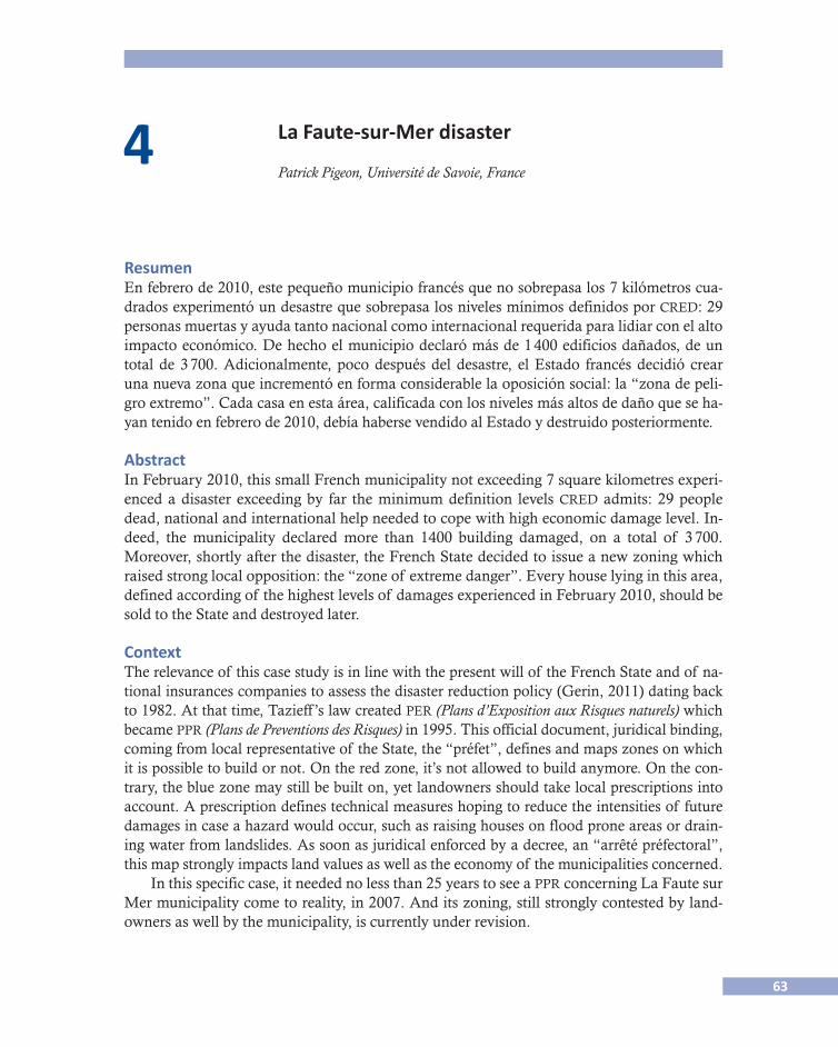
63
4 La Faute-sur-Mer disaster
Patrick Pigeon, Université de Savoie, France
ResumenEn febrero de 2010, este pequeño municipio francés que no sobrepasa los 7 kilómetros cua-drados experimentó un desastre que sobrepasa los niveles mínimos definidos por cred: 29 personas muertas y ayuda tanto nacional como internacional requerida para lidiar con el alto impacto económico. De hecho el municipio declaró más de 1 400 edificios dañados, de un total de 3 700. Adicionalmente, poco después del desastre, el Estado francés decidió crear una nueva zona que incrementó en forma considerable la oposición social: la “zona de peli-gro extremo”. Cada casa en esta área, calificada con los niveles más altos de daño que se ha-yan tenido en febrero de 2010, debía haberse vendido al Estado y destruido posteriormente.
AbstractIn February 2010, this small French municipality not exceeding 7 square kilometres experi-enced a disaster exceeding by far the minimum definition levels cred admits: 29 people dead, national and international help needed to cope with high economic damage level. In-deed, the municipality declared more than 1400 building damaged, on a total of 3 700. Moreover, shortly after the disaster, the French State decided to issue a new zoning which raised strong local opposition: the “zone of extreme danger”. Every house lying in this area, defined according of the highest levels of damages experienced in February 2010, should be sold to the State and destroyed later.
ContextThe relevance of this case study is in line with the present will of the French State and of na-tional insurances companies to assess the disaster reduction policy (Gerin, 2011) dating back to 1982. At that time, Tazieff ’s law created per (Plans d’Exposition aux Risques naturels) which became ppr (Plans de Preventions des Risques) in 1995. This official document, juridical binding, coming from local representative of the State, the “préfet”, defines and maps zones on which it is possible to build or not. On the red zone, it’s not allowed to build anymore. On the con-trary, the blue zone may still be built on, yet landowners should take local prescriptions into account. A prescription defines technical measures hoping to reduce the intensities of future damages in case a hazard would occur, such as raising houses on flood prone areas or drain-ing water from landslides. As soon as juridical enforced by a decree, an “arrêté préfectoral”, this map strongly impacts land values as well as the economy of the municipalities concerned.
In this specific case, it needed no less than 25 years to see a ppr concerning La Faute sur Mer municipality come to reality, in 2007. And its zoning, still strongly contested by land-owners as well by the municipality, is currently under revision.

64
The figure below (Fig. 4.1) may help to understand why this ppr raised such a strong opposition coming from the landowners as well as from the municipality. Indeed, let’s consi-der that the red zone reduces the already poor building capacities of this communal terri-tory. It belongs to one of the smallest of the more than 36 600 French municipalities. In that case, the area does not exceed 7 square-kilometers, including beaches as well as coastal fo-rests devoted to defence against the sea. Even more, let’s mention the existing red zone strip which borders the dike and which displays its possible unwanted effects. In case of a future possible breaching of the dike, the event would increase even more the intensity of the mor-tality and economic damages in its vicinity. But the red zone strip includes existing buil-dings, and it fuels even more the opposition of their owners to existing ppr zonings.
27 years needed for a risk prevention plan by the french state, 2010.
Atlantic ocean
LayL’ Aiguillon
LayRiver
La Faute
2002Original scale: 1/10 000
Fig. 4.1. Risk prevention plan, 2002. Map juridically enforced by prefectoral decision, 8 June 2007.
Yet, such a situation cannot be considered interesting enough on this basis only, because we may find other French municipalities fighting against PPR zonings, such as Pont-de-Claix for example, which lies in the southern part of Grenoble urban area. This situation is nothing new (Pigeon, 1994). But in that case, shortly after the event, the French State decided to issue a new zoning type. This new map has been intended to identify the areas which experienced the highest levels of damages during the floods. The new zone name has evolved with time, “zone of extreme danger” but also “black zone” or “zone of national solidarity”. The idea behind would be to call for national solidarity. The French state would buy the houses lying

65
in this black zone, and destroy them shortly later, admitting these areas shouldn’t have been built on because of the existing flood risk. This process is today in the making.
Let’s stress on the fact that the “tribunal administratif de Nantes” judged this tool as not juridical relevant. This judgement proves that we experience a tool which is totally new in-deed. It came as an outcome of La Faute-sur-Mer disaster. Shortly written, the present French disaster reduction policy has been found not sufficient enough, calling for adapta-tions and evolutions, if not strong transformations. It should also be possible to justify dis-tinguishing between a disaster, which relies on statistical like approach, the intensity of the damage experienced after an event, and a catastrophe, which implies a transformation of a system basic structures (Bak, 1999).
We reported on Fig. 4.2 the extension of this “black zone”. The map itself helps to un-derstand the local opposition of landowners not allowing to see their homes destroyed by a State decision, even though the majority of these buildings are second homes. Fig. 4.3 re-veals the local intensity of the opposition, on the southern tip of the black zone.
Fig. 4.2. Trends of urbanization and urbanization phases in the “black zone”.
Recreational infraestructure
on the floodplain of the Lay
Dykes
Road on dykes
1963 Virly port
1966 Campground
Geology
Coastal dune
Historical and current minor
bed of Lay and mudflat
Position of the tip of Arçay
ca 1750
Phases of urbanization
in the “zone of extreme danger”
Partial ocupation before 1963
1963-1977
1977-1984
1984-2006
After 2006
66
Issues Related with FP7 Programme Could be as FollowsLa Faute sur Mer disaster field study would help us identifying the discrepancy between what the French State targeted (disaster prevention using ppr tool) and what we found in this specific case (one of the biggest disaster France experienced, be it in terms of mortality levels only). Of course, the problem is strongly related with the necessity to identify and un-derstand why we have such a poor acceptance of regulations coming from the State. It would be a contribution to a wide range of studies concerning this issue, be they in disaster risk reduction policy field or in climate change adaptation field research (Quenault et al., 2011). At the French national level, stakes are ranked high indeed; insurance companies are heavily imbedded in the French risk management system. They try to curb the existing trend towards more disaster frequencies, which constrains even more the present system, and may reduce their benefits with time. Sarah Gérin PhD (2011), which implied a strong partnership with “Mission des risques naturels”, a lobby like institution pushing forward the insurance companies positions in front of the French State if not of the European commission, reveals the assets related with the poor political and local acceptance of ppr maps.
It would need to find back urbanization phases, crisscrossing them with areas conside-red officially flood-prone: in this case, crisscrossing ppr zones and/or the zone of extreme danger with urbanization that took place on these areas. It implies working on ancient ca-dastres, and on municipal as well as departmental archives, in order to gain more precise in-formation on the trend that favoured the 2010 disaster.
It would also need to find back local political choices concerning municipal building re-gulations. Why do we find the paradoxical choice of a low-rise urbanization for a municipa-lity no exceeding 7 square-kilometres, and already living with various building constraints in relation with the sea-shore? Indeed, we already know that the municipal council agreed on the necessity not to allow building heights exceeding 9 metres on the more urbanized parts of the municipality. This information has been officially displayed on the “plan local d”urbanisme”, a French local map which defines juridical rules allowing construction. But why such a strong and effectively enforced regulation has been maintained with time, wha-tever the municipality, is still to be investigated in depth.
This would help to understand the mortality characteristics experienced: more of two-third of people dead exceeded 60 years. Tracing back socio-economic peculiarities of the municipality may be considered a crucial task to be performed here.
On a more theoretical basis, it would help to question resilience and/or adaptation defi-nitions: what may be resilience and for which group of political actors? Adaptation as such is poorly significant. As for any risk type, we should find back a range of risks, and sort out which ones were considered relevant according to the municipality and the political actors supporting it, such as landowners.
One of the hypotheses that would be tested during the study: the municipal community succeeded in discarding every try of the French State to transform local policy choices and to prevent a flood-related disaster (until February 2010). In this case, we could see PPR map refusal (among other type of political oppositions) as a means to maintain local settlement structures, contributing, therefore, to prepare the February 2010 disaster. As time goes on,
67
the choice to build low-rise pushes new constructions towards more flood prone areas. This is exactly what we found back during preliminary investigations (Fig. 4.2). Indeed, ppr red zones cannot allow anymore low-rise building, because they reduce even more the areas on which it would be possible to build. If we admit that resilience may define the capacity of a system to maintain its basic structure while reducing the impacts of events, according to Walker and Salt (2006) definition, this municipality succeeded to be resilient. Therefore, while being resilient in that sense, it contributed to prepare a disaster (mortality level), but also a catastrophe (transformation of the basic structure of the local settlement system).
Shortly written, in the eyes of La Faute sur Mer municipality, the disaster was not so much a future flood, but the potentially ca-tastrophic ppr zonings the French State tried to enforce while hoping to prevent a future flood disaster. The existing black zone can-not give the municipality any other solution but to change the basic structure of the local settlement, and this may be related with a ca-tastrophe, in line with what Bak (1999) wrote on catastrophe theory.
Under these circumstances, La Faute-sur-Mer case study would help us testing the relevance and the limits of preventing disas-ters while relying on the local capacities of a
Fig. 4.3. La Faute sur Mer: inhabitants claims.
community. In that case, enhancing local resilience contributed to favour the disaster which has been experienced in 2010. On the contrary, the French State tried to prevent the 2010 disaster but did not succeed in doing so until recently, in the aftermath of the disaster which also brought the catastrophic black zone with it. Now, La Faute sur Mer municipality has to resign its political previous choices concerning low-rise buildings.
Under these conditions, issues related with political acceptance of regulations, and of existing knowledge, may be concerned by this case study as well. The key point is strongly related with the acceptance levels of decision coming, in that case, from the French State. Creating a new tool identifying conflicts and rationale behind would greatly help identifying trends towards disasters, and also when the potential constructive part of resilience (as pre-venting disaster) may turn to favour disaster, when the local settlement system loses flexibili-ty and in learning capacity.
68
References
Bak P. 1999 Quand la nature s’organise, Paris, Flammarion, 283 p.Dauphine, A. 2003 Les théories de la complexité chez les géographes, Economica-Anthropos, Paris, p. 248.Gerin, S. 2011 “Une démarche évaluative des Plans de Prévention des Risques dans le contexte de l”
assurance des catastrophes naturelles: contribution au changement de l”action pub-liquedeprévention˝.ThèseUniv.ParisVII,p.256.
Pigeon, P. 2010 ˝Catastrophesditesnaturelles,risquesetdéveloppementdurable:Utilisationsgéogra-
phiques de la courbe de Farmer˝, VertigO � la revue électronique en sciences de l”environnement [En ligne], vol. 10, num. 1, avril, [En ligne] mis en ligne le 26 avril 2010. URL: (http://vertigo.revues.org/9491) Consulté le 11 janvier 2011.
Quenault, B., P. Pigeon, F. Bertrand and N. Blond 2011 Vulnérabilité et résilience au changement climatique en milieu urbain: vers de nouvelles
stratégies de développement urbain durable? Rapport programme pirve, Axe 3. Les fu-turs de la ville entre vulnérabilité et durabilité: 203 p.
Walker, B. and D. Salt 2006 Resilience Thinking. Sustaining Ecosystems and People in a Changing World, Washington, Is-
land Press, 174 p.Weichselgartner, J and J. Sendzimir 2004 Resolving the paradox. food for thought on the wider dimension of natural hazards.
mountain research and development, vol. 24, num. 1, pp. 4-9.White, G.F., R.W. Kates and I. Burton 2001 “Knowing better and losing even more: the use of knowledge in hazard management”,
Global environmental change, environmental hazards, vol. 3, num. 3-4, pp. 81-92.
Contact Patrick Pigeon, Université de Savoie, France, <[email protected]>.
69
CASOS ASIÁTICOS
ASIAN CASES

71
5 More to Lose: Reducing Family Vulnerability to Flood and Storm Damage in Central Vietnam,
1989 - 2010
John Norton & Guillaume Chantry, Development Workshop France, France
ResumenLa estrategia de reducción de riesgo de desastre en Vietnam no presta la suficiente atención a la capacidad de las familias y de las comunidades locales de jugar un papel fundamental en reducir su propia vulnerabilidad a inundaciones y tifones. Los acercamientos descendentes necesitan combinarse con el potencial de reducción de riesgo de desastre con base en la co-munidad. El Programa de Development Workshop France (dwf) demuestra de forma eficiente que las comunidades pueden ser una fuerza dinámica en reducir riesgos relacionados direc-tamente con los contextos locales, y que su potencial puede movilizarse por medio de pla-neación de reducción de riesgo de desastre a nivel comunitario, capacitación y alcance, así como por medio del fortalecimiento preventivo de la vivienda y los edificios públicos, donde la pérdida de viviendas es en particular un gran retraso familiar con repercusiones en todos los demás aspectos de la vida familiar y el desarrollo. El Programa es práctico, eficiente y rentable. Las familias y las comunidades están convencidas, por medio del ejemplo y el mensaje, de la acción preventiva e invierten su dinero en hacer casas más seguras con resul-tados tangibles y concretos al momento en que los desastres ocurren.
Abstract Vietnam’s disaster risk reduction strategy pays insufficient attention to the capacity of fami-lies and local communities to play a key role in reducing their own vulnerability to floods and typhoons. Top-down approaches need to mesh with community-based disaster risk re-duction potential. A Development Workshop France (dwf) programme efficiently demon-strates that communities can be a dynamic force in reducing risks directly related to local contexts, and that their potential can be mobilized through participatory commune level di-saster risk reduction planning, training and outreach and preventive strengthening of housing and public buildings. The dwf Programme helps reduce the impact of typhoons and floods on housing and public buildings, loss of housing being specifically a major family setback with repercussions on all other aspects of family life and development. The Programme is practical, efficient and cost effective. Families and communities are convinced by the exam-ple and the message for preventive action and put their money into making their homes safer after seeing the concrete and tangible results this produced when disasters strike.
ThesisThose poor families in Central Vietnam will invest in making their home safe against the im-pact of floods and storms, recognizing that this investment protects their ability to develop and improve family conditions and income.
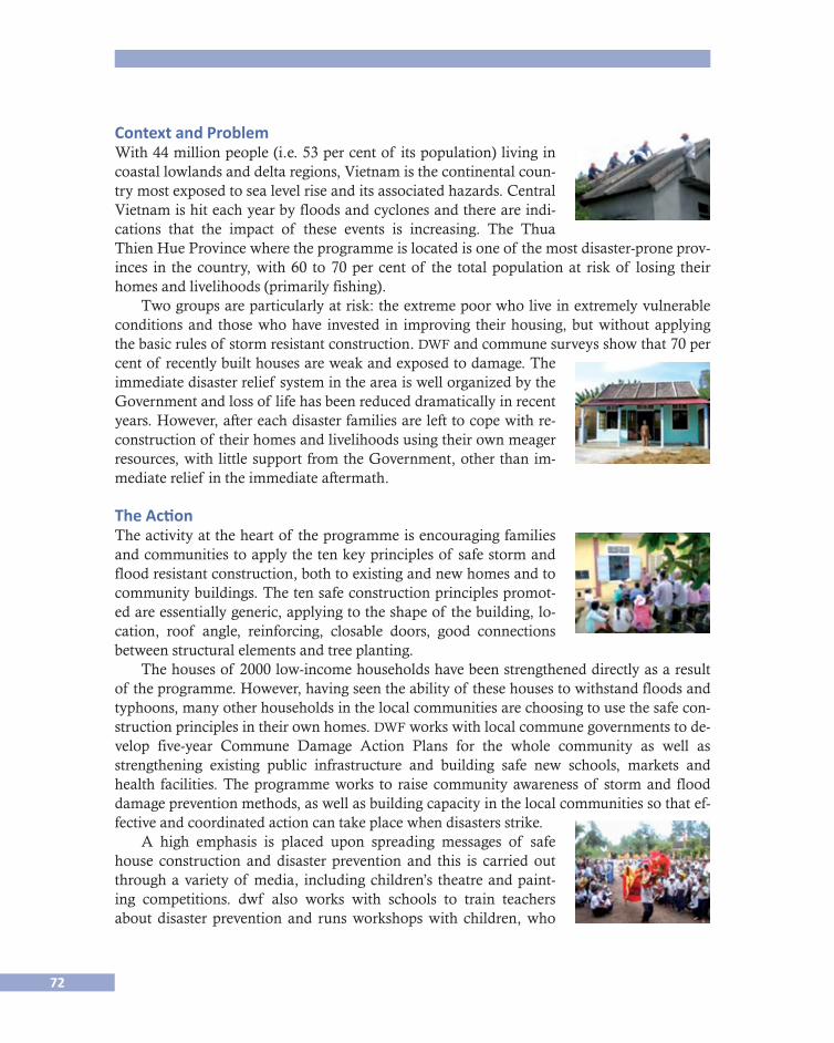
72
Context and ProblemWith 44 million people (i.e. 53 per cent of its population) living in coastal lowlands and delta regions, Vietnam is the continental coun-try most exposed to sea level rise and its associated hazards. Central Vietnam is hit each year by floods and cyclones and there are indi-cations that the impact of these events is increasing. The Thua Thien Hue Province where the programme is located is one of the most disaster-prone prov-inces in the country, with 60 to 70 per cent of the total population at risk of losing their homes and livelihoods (primarily fishing).
Two groups are particularly at risk: the extreme poor who live in extremely vulnerable conditions and those who have invested in improving their housing, but without applying the basic rules of storm resistant construction. dwf and commune surveys show that 70 per cent of recently built houses are weak and exposed to damage. The immediate disaster relief system in the area is well organized by the Government and loss of life has been reduced dramatically in recent years. However, after each disaster families are left to cope with re-construction of their homes and livelihoods using their own meager resources, with little support from the Government, other than im-mediate relief in the immediate aftermath.
The ActionThe activity at the heart of the programme is encouraging families and communities to apply the ten key principles of safe storm and flood resistant construction, both to existing and new homes and to community buildings. The ten safe construction principles promot-ed are essentially generic, applying to the shape of the building, lo-cation, roof angle, reinforcing, closable doors, good connections between structural elements and tree planting.
The houses of 2000 low-income households have been strengthened directly as a result of the programme. However, having seen the ability of these houses to withstand floods and typhoons, many other households in the local communities are choosing to use the safe con-struction principles in their own homes. dwf works with local commune governments to de-velop five-year Commune Damage Action Plans for the whole community as well as strengthening existing public infrastructure and building safe new schools, markets and health facilities. The programme works to raise community awareness of storm and flood damage prevention methods, as well as building capacity in the local communities so that ef-fective and coordinated action can take place when disasters strike.
A high emphasis is placed upon spreading messages of safe house construction and disaster prevention and this is carried out through a variety of media, including children’s theatre and paint-ing competitions. dwf also works with schools to train teachers about disaster prevention and runs workshops with children, who
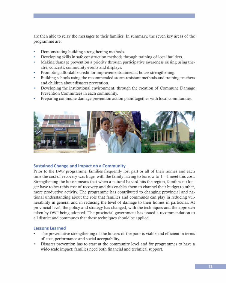
73
are then able to relay the messages to their families. In summary, the seven key areas of the programme are:
• Demonstrating building strengthening methods.• Developing skills in safe construction methods through training of local builders. • Making damage prevention a priority through participative awareness raising using the-
atre, concerts, community events and displays. • Promoting affordable credit for improvements aimed at house strengthening. • Building schools using the recommended storm-resistant methods and training teachers
and children about disaster prevention. • Developing the institutional environment, through the creation of Commune Damage
Prevention Committees in each community. • Preparing commune damage prevention action plans together with local communities.
Sustained Change and Impact on a CommunityPrior to the dwf programme, families frequently lost part or all of their homes and each time the cost of recovery was huge, with the family having to borrow to 1 ‘--I meet this cost. Strengthening the house means that when a natural hazard hits the region, families no lon-ger have to bear this cost of recovery and this enables them to channel their budget to other, more productive activity. The programme has contributed to changing provincial and na-tional understanding about the role that families and communes can play in reducing vul-nerability in general and in reducing the level of damage to their homes in particular. At provincial level, the policy and strategy has changed, with the techniques and the approach taken by dwf being adopted. The provincial government has issued a recommendation to all district and communes that these techniques should be applied.
Lessons Learned• Thepreventativestrengtheningof thehousesof thepoorisviableandefficientinterms
of cost, performance and social acceptability. • Disasterpreventionhastostartatthecommunitylevelandforprogrammestohavea
wide-scale impact; families need both financial and technical support.
74
• Whilstfamiliesmayhaveotherprioritiesintheirlives(education,health,andincomegeneration) they recognise that the house is a key component in achieving these priori-ties and are prepared to invest.
• Thevisiblesolutions,e.g.ribsontheroof,havenotalwaysmatchedimportantlocalval-ues of perceived beauty, so that the buildings of the poor call for architectural care and quality as much as technical and built quality. Safety is important, but so is beauty.
• Eachbuildinghas itsownneeds, strengthsandweaknessesand it is important to re-spond to these micro-architectural requirements.
• Introducinginnovationtakestimeforbothbeneficiariesandcommunityleaders.
References
adrc
2007 Good practices supplement “More to lose - reducing family vulnerability to floods and storms”, Development Workshop project in Central Vietnam.
isdr
2007 Building Disaster Resilient Communities, Flood and Typhoon resilient homes through cost effective retrofitting, p. 52.
Norton J. and G. Chantry 2008 “Vaccinate your Home Against the Storm - Reducing Vulnerability in Vietnam”, Open
House International, vol. 33, no. 2, June, . 2008 “More to Lose - the case for prevention, loans for strengthening and safe housing in-
surance - the case if central Vietnam”, in Hazards and the built environment - attain-ing built in resilience, Ed. Lee Bosher/Routledge/Taylor & Francis.
n. d. “Flood and Typhoon-Resilient Homes through Cost-Effective Retrofitting —“Vacci-nate Your Home” - Preventive Action to Reduce Damage Caused by Floods and Ty-phoons in Vietnam, unesco, Paris.
unesco
2005 Disaster reduction and Human Security Case studies and Best practices Kobe, En-hancing Community Capacity to reduce vulnerability to economic loss caused by storm damage to houses in Central Vietnam.
Contact John Norton, Development Workshop France (dwf): <[email protected]>.
75
6 Sustainability and Feasibility of Insurance Tools for Compensating Losses due to Natural Hazards
in Vietnam
Huong Tra Nguyen & Scira Menoni, Politecnico di Milano, Italy
ResumenEn los últimos años, tanto los desastres naturales como los creados por el hombre han afec-tado a un número creciente de personas en todo el mundo. Los presupuestos de emergencia y la ayuda humanitaria se han disparado (Matthew E. Kahn, 2003). Por tanto, hay una alta demanda ante la necesidad de contar con herramientas efectivas para mitigar los daños de desastres naturales. De entre los instrumentos para sobrellevar las secuelas de las amenazas naturales, los seguros han probado su efectividad al proteger a los contratantes contra pérdi-das económicas causadas por los peligros naturales. Por medio del pago de una prima men-sual o anual, el contratante recibirá una indemnización por parte de la aseguradora en caso de que ocurra un siniestro o desastre de los que se mencionan en el contrato. Este mecanis-mo existe, así como aquellos que son de cobertura básica.
AbstractIn recent years, natural and man-made disasters have affected increasing numbers of people throughout the world. Budgets for emergency and humanitarian aid have skyrocketed (Mat-thew E. Kahn, 2003). Therefore, the necessity of establishing effective tools to mitigate the damages of natural disasters is in high demand. Among instruments for coping with the af-termaths of natural hazards, insurance proves to be effective in protecting buyers against economic losses caused by natural perils. With a premium paid monthly or yearly, the buyer will receive a repayment from insurer in case a disaster which listed in the contract occurs. This mechanism is likely as those of basic insurance notion.
Hypothesis/ObjectiveIn the thesis titled “Damage Assessment and Financial Risk Mitigation Tool against Storms in the Middle of Vietnam” developed by Huong Tra Nguyen and supervised by Scira Me-noni, the issue of sustainability and feasibility of insurance tools in countries like Vietnam has been investigated. In order to propose an application of the first findings, an insurance package for agriculture suitable the condition of Vietnam has been suggested. Such a tool has been designed in a ways it may help Vietnamese Government and Farmers coping with the destruction provoked by storms to the agriculture sector.
Context and ProblemIn recent years, natural and man-made disasters have affected increasing numbers of people throughout the world. Budgets for emergency and humanitarian aid have skyrocketed (Mat-thew E. Kahn, 2003). Therefore, the necessity of establishing effective tools to mitigate the
76
damages of natural disasters is in high demand. Among instruments for coping with the af-termaths of natural hazards, insurance proves to be effective in protecting buyers against economic losses caused by natural perils. With a premium paid monthly or yearly, the buyer will receive a repayment from insurer in case a disaster which listed in the contract occurs. This mechanism is likely as those of basic insurance notion.
In rich country, insurance against natural disaster is well developed because vital condi-tions for implementation are satisfied. Firstly, experts and information accesses are readily available in developed countries. This is important for being able to evaluate what insurance product is feasible in a given area subject to certain hazards. Besides, data and experts are needed for damage assessment in disasters” aftermath so that the insurer can define an ade-quate repayment to buyer. Depending on the hazards and the aims of insurance products, data needed could be geological and meteorological parameters, market information, his-torical damage records, etc.
Secondly, the premium required is acceptable for potential buyers in rich countries while it’s relatively high for the majority of people in poor countries.
Thirdly, high-income countries address problems which hinder the success of disaster insurance: poor preparedness and preventive measures against natural disasters. With a bet-ter measures, for example good urban planning, higher construction standards, effective nat-ural disaster warning systems, etc, rich countries can equip themselves a good shield against natural destructions. It helps to reduce the risk of losses for properties and death tolls, con-sequently descending the number and value of claims to insurance company. Therefore in-surer can avoid the situation of insolvency which is their highest concern.
Therefore the question posed in the thesis is whether or not this instrument is suitable for developing countries even though they hardly satisfy the three conditions discussed above and are in the meantime frequently stricken by natural disaster.
What has been done?Because of geographical position, contiguous to the East Sea, Vietnam has a high exposure to storm hazards. Annual damage is up to 0.5% of total Gross Domestic Product. Based on statistical data, we found out that agriculture is among the mostly damaged sectors due to storms and thus it may significantly benefit from financial risk mitigation. Though, a well suited instrument that overcomes the challenges deep rooted in the market condition of Viet-nam has to be looked for. Three agriculture insurance products were tested in a virtual appli-cation: Multi Peril Crop Insurance (mpci), Crop Revenue Insurance (cri), and Weather Index Crop Insurance (wici).
In order to carry out the application, detailed data from a survey 100 households in Ky Loi and Ky Linh communes in the Middle of Vietnam were used. 59% of these households have their main occupation in agriculture, 10% are in the poverty category. Because the re-gion is on the coastline, 98% of losses due to natural hazards are actually provoked by storms. The total loss per year during the last 10 years is 14,024 eur. None of household in that region has ever purchased disaster insurance. Using the rather detailed data available
77
from a study conducted by the Poverty Environment Partnership, an informal network of development agencies (Pep, 2008), indemnity calculations adopting the three identified in-surance typologies was performed.
The mpci and the cri do not seem to be suitable for the case study because of their high administrative costs leading to high premium prices. Besides, with small size farms, non-standard management and cultivation methods (mostly based on experience), lack of disas-ter risk data, undeveloped and unstable crop market, those two insurance products have no feasible implementation perspective. The case of wici is somewhat different, because a phy-sical parameter, the Beaufort wind speed scale from 6 to 13 is used to define thresholds and limits for loss compensations. If the actual wind speed reaches scale 6, indemnity begins to release proportionally. Payout will remain max value until the wind velocity reaches or over the limit scale 13. This insurance product proves to be the best solution because of the objec-tive data collection method, low administration cost, quick payout, no moral hazards and adverse selection.
A strategy of risk transfer has been proposed as well within the thesis so as to suggest the feasibility conditions of the wici insurance type for the Vietnam, including governmen-tal subsidy to help households to pay their premium price: at the rate of 80 - 90% for poor households, 60% for non-poor households, and 50% for farming groups or enterprises. Besi-des, Agriculture Bank —a main lender of 77% farmer household in Vietnam— has to asso-ciate lending money with mandatory agriculture insurance purchase. This requirement will protect both lenders and farmers against losses due to natural disasters. At a higher level, reinsurance is a risk transfer instrument in order to diversify the risk and avoid an excess of claim.
Key PointsIn conclusion, wici is highly recommended for Vietnam agriculture in general and the case study in particular. However, to have a successfully implementation, insurance company will have to combine with other supports from government and local authorities.
Potential Impact (on Community/Target Group)There have been several attempts to introduce insurance against natural hazards in
poor/developing countries. Despite what is commonly thought, it is not a measure suitable only for rich countries. A number of advantages can be cited in general, as for example the larger stability of economic growth when huge capitals do not have to be diverted for recon-struction purposes from other budgetary chapters of the state; because it alleviate the ad-ministrative burden of compensation from governmental offices to private companies that have larger experience in damage assessment and repayment mechanisms. Last but not least the introduction of insurance may trigger a positive mitigation feedback, by introducing mitigation as a means for reducing premium.

78
Assessment Grid
Interest groups
Scope
Yes
No
Nationalgovernment
Localgovernment
Services/skills
CommunityFamily and individual
Theory Yes
Policy Yes
Practice Yes
Dissemination Yes
4. Shared responsibility (governance)
Yes
5. Knowledge
6. Information exchange
References
General Statistic Office (gso) 2008 Result of the Survey on Household Living Standards 2008, Statistical Public House.Globalagrisk 2009 Designing Agricultural Index Insurance in Developing Countries: A GlobalAgRisk Market De�
velopment Model Handbook for Policy and Decision Makers, Lexington, ky.GoV 2004 National Report on Disaster Reduction in Vietnam, For the World Conference on Disaster Re�
duction, Kobe-Hyogo, Japan, 18-22 January 2005, Hanoi, September.Linnerooth-Bayer, J., M. Mace and R. Verheyen 2003 Insurance related actions and risk assessment in the context of the United Nations Framework
Convention on Climate Change (unfccc), May, Background paper.Matthew E. Kahn 2003 The Death Toll from Natural Disasters: The Role of Income, Geography, and Institutions, Sep-
tember 3rd, Matthew E. Kahn Tufts, University and Stanford University.Margaret, Arnold 2008 The Role of Risk Transfer and Insurance in Disaster Risk Reduction and Climate Change Adap�
tion, Commission on Climate Change and Development, March, Provention Consortium.Poverty And Environment Project (pep) 2008a Climate Change Adaptation and The Poor, July.

79
Poverty And Environment Project (pep) 2008b Database of Ha Tinh Province, July.Shri R.C.A.J. 2004 Challenges in Implementing Agriculture Insurance and Re�insurance in Developing Country,
June, Ministry of Agriculture & Cooperation, Govt. of India, New Delhi.World Bank 2009 Insurance for the Poor Program. Public Intervention for Agricultural Insurance.World Bank 2010 Weathering the Storm: Options for Disaster Risk Financing in Vietnam.
Contacts Scira Menoni, diap- Politecnico di Milano, Italy: <[email protected]>. Huong Tra Nguyen: <[email protected]>.

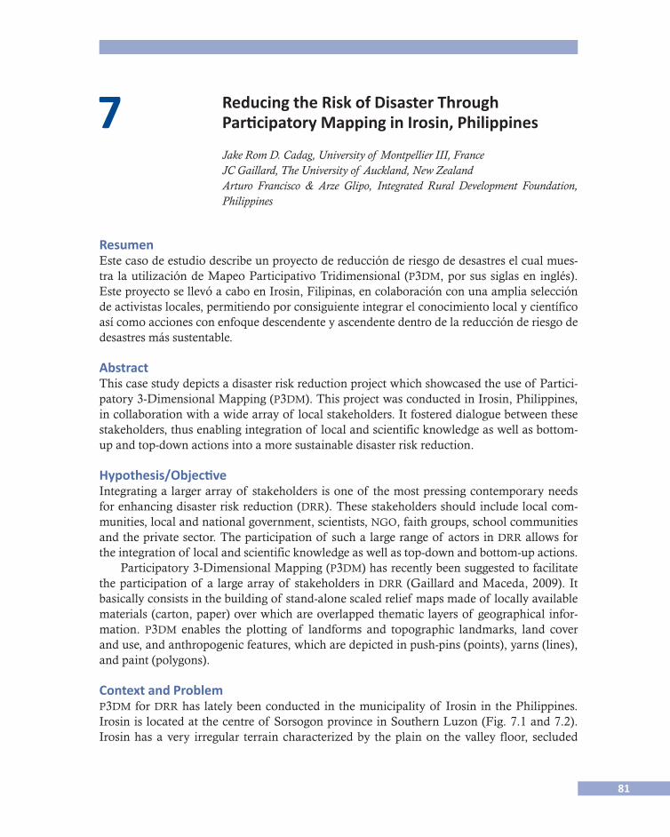
81
7 Reducing the Risk of Disaster Through Participatory Mapping in Irosin, Philippines
Jake Rom D. Cadag, University of Montpellier III, France JC Gaillard, The University of Auckland, New Zealand Arturo Francisco & Arze Glipo, Integrated Rural Development Foundation, Philippines
ResumenEste caso de estudio describe un proyecto de reducción de riesgo de desastres el cual mues-tra la utilización de Mapeo Participativo Tridimensional (p3dm, por sus siglas en inglés). Este proyecto se llevó a cabo en Irosin, Filipinas, en colaboración con una amplia selección de activistas locales, permitiendo por consiguiente integrar el conocimiento local y científico así como acciones con enfoque descendente y ascendente dentro de la reducción de riesgo de desastres más sustentable.
AbstractThis case study depicts a disaster risk reduction project which showcased the use of Partici-patory 3-Dimensional Mapping (p3dm). This project was conducted in Irosin, Philippines, in collaboration with a wide array of local stakeholders. It fostered dialogue between these stakeholders, thus enabling integration of local and scientific knowledge as well as bottom-up and top-down actions into a more sustainable disaster risk reduction.
Hypothesis/ObjectiveIntegrating a larger array of stakeholders is one of the most pressing contemporary needs for enhancing disaster risk reduction (drr). These stakeholders should include local com-munities, local and national government, scientists, ngo, faith groups, school communities and the private sector. The participation of such a large range of actors in drr allows for the integration of local and scientific knowledge as well as top-down and bottom-up actions.
Participatory 3-Dimensional Mapping (p3dm) has recently been suggested to facilitate the participation of a large array of stakeholders in drr (Gaillard and Maceda, 2009). It basically consists in the building of stand-alone scaled relief maps made of locally available materials (carton, paper) over which are overlapped thematic layers of geographical infor-mation. p3dm enables the plotting of landforms and topographic landmarks, land cover and use, and anthropogenic features, which are depicted in push-pins (points), yarns (lines), and paint (polygons).
Context and Problemp3dm for drr has lately been conducted in the municipality of Irosin in the Philippines. Irosin is located at the centre of Sorsogon province in Southern Luzon (Fig. 7.1 and 7.2). Irosin has a very irregular terrain characterized by the plain on the valley floor, secluded
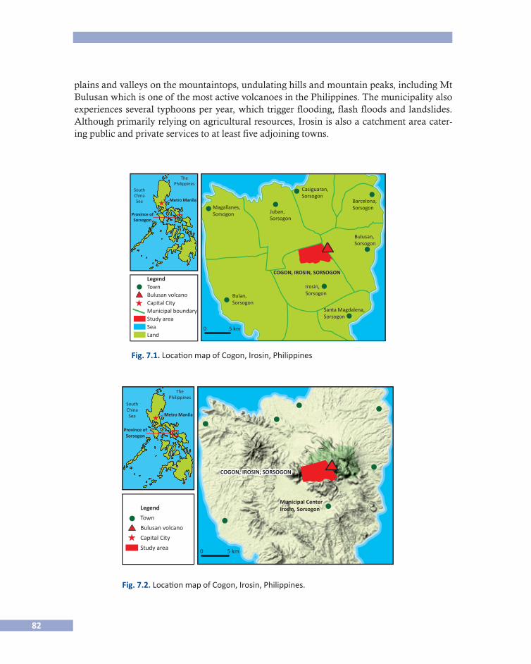
82
plains and valleys on the mountaintops, undulating hills and mountain peaks, including Mt Bulusan which is one of the most active volcanoes in the Philippines. The municipality also experiences several typhoons per year, which trigger flooding, flash floods and landslides. Although primarily relying on agricultural resources, Irosin is also a catchment area cater-ing public and private services to at least five adjoining towns.
Magallanes,Sorsogon
SouthChinaSea
LegendTownBulusan volcanoCapital CityMunicipal boundaryStudy areaSeaLand
Metro Manila
Province ofSorsogon
Juban,Sorsogon
Casiguaran,Sorsogon
Barcelona,Sorsogon
Bulusan,Sorsogon
Bulan,Sorsogon
0 5 km
Irosin,Sorsogon
Santa Magdalena,Sorsogon
COGON, IROSIN, SORSOGON
ThePhilippines
Fig. 7.1. Location map of Cogon, Irosin, Philippines
Fig. 7.2. Location map of Cogon, Irosin, Philippines.
SouthChinaSea
Legend
Town
Bulusan volcano
Capital City
Study area
Metro Manila
Province ofSorsogon
0 5 km
Municipal CenterIrosin, Sorsogon
COGON, IROSIN, SORSOGONCOGON, IROSIN, SORSOGON
ThePhilippines

83
What Has Been Done?A p3dm for drr project was conducted in the village of Cogon located on the slopes of Mt Bulusan. The village’s political territory covers more than 1700 hectares with the forest and the actual slopes of the volcano comprising more than 80 percent of the total land area. Most people live 5 kilometres south-west from the crater of volcano in a single settlement located beyond the zone permanent danger defined by the Philippine Institute of Volcanolo-gy and Seismology. The local community first and foremost relies on coconut plantations which are located on the upper slopes of Mt Bulusan, within the area of highest danger in the event of an eruption. Both the settlement and coconut plantations are threatened by la-hars which scramble down the Cogon River after each eruption.
p3dm for drr was conducted from 16 to 20 February 2010 with the help of the Comité Catholique contre la Faim et pour le Développement (ccfd) through the Integrated Rural Development Foundation (irdf). The primary objective of the project was to strengthen the ability of the local community to face the most recent eruption of Mt Bulusan which started late in 2010. A number of stakeholders participated including the local community, the vi-llage Disaster Coordinating Council, the Municipal Government of Irosin, the local ele-mentary school community, scientists and irdf. Such a project turned out to be of critical importance because a majority of the village’s officials were newly elected and not yet fami-liar with drr policy and practice.
Fig. 7.3. Small-scale participatory 3-dimensional map (1:6000) of Cogon, Irosin, Philippines. February 2011 (photograph by J.R.D. Cadag).
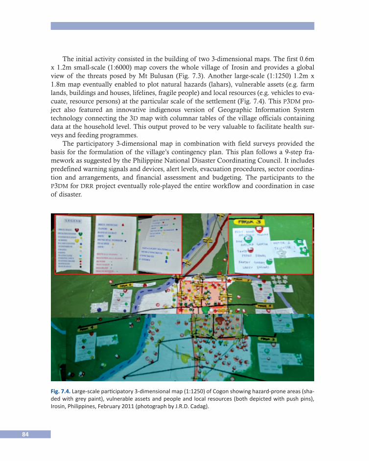
84
The initial activity consisted in the building of two 3-dimensional maps. The first 0.6m x 1.2m small-scale (1:6000) map covers the whole village of Irosin and provides a global view of the threats posed by Mt Bulusan (Fig. 7.3). Another large-scale (1:1250) 1.2m x 1.8m map eventually enabled to plot natural hazards (lahars), vulnerable assets (e.g. farm lands, buildings and houses, lifelines, fragile people) and local resources (e.g. vehicles to eva-cuate, resource persons) at the particular scale of the settlement (Fig. 7.4). This p3dm pro-ject also featured an innovative indigenous version of Geographic Information System technology connecting the 3d map with columnar tables of the village officials containing data at the household level. This output proved to be very valuable to facilitate health sur-veys and feeding programmes.
The participatory 3-dimensional map in combination with field surveys provided the basis for the formulation of the village’s contingency plan. This plan follows a 9-step fra-mework as suggested by the Philippine National Disaster Coordinating Council. It includes predefined warning signals and devices, alert levels, evacuation procedures, sector coordina-tion and arrangements, and financial assessment and budgeting. The participants to the p3dm for drr project eventually role-played the entire workflow and coordination in case of disaster.
Fig. 7.4. Large-scale participatory 3-dimensional map (1:1250) of Cogon showing hazard-prone areas (sha-ded with grey paint), vulnerable assets and people and local resources (both depicted with push pins), Irosin, Philippines, February 2011 (photograph by J.R.D. Cadag).
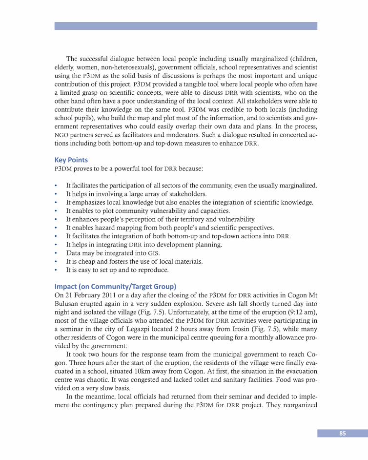
85
The successful dialogue between local people including usually marginalized (children, elderly, women, non-heterosexuals), government officials, school representatives and scientist using the p3dm as the solid basis of discussions is perhaps the most important and unique contribution of this project. p3dm provided a tangible tool where local people who often have a limited grasp on scientific concepts, were able to discuss drr with scientists, who on the other hand often have a poor understanding of the local context. All stakeholders were able to contribute their knowledge on the same tool. p3dm was credible to both locals (including school pupils), who build the map and plot most of the information, and to scientists and gov-ernment representatives who could easily overlap their own data and plans. In the process, ngo partners served as facilitators and moderators. Such a dialogue resulted in concerted ac-tions including both bottom-up and top-down measures to enhance drr.
Key Pointsp3dm proves to be a powerful tool for drr because:
• It facilitates the participation of all sectors of the community, even the usually marginalized.• It helps in involving a large array of stakeholders.• It emphasizes local knowledge but also enables the integration of scientific knowledge.• It enables to plot community vulnerability and capacities.• It enhances people’s perception of their territory and vulnerability.• It enables hazard mapping from both people’s and scientific perspectives.• It facilitates the integration of both bottom-up and top-down actions into drr.• It helps in integrating drr into development planning.• Data may be integrated into gis.• It is cheap and fosters the use of local materials.• It is easy to set up and to reproduce.
Impact (on Community/Target Group)On 21 February 2011 or a day after the closing of the p3dm for drr activities in Cogon Mt Bulusan erupted again in a very sudden explosion. Severe ash fall shortly turned day into night and isolated the village (Fig. 7.5). Unfortunately, at the time of the eruption (9:12 am), most of the village officials who attended the p3dm for drr activities were participating in a seminar in the city of Legazpi located 2 hours away from Irosin (Fig. 7.5), while many other residents of Cogon were in the municipal centre queuing for a monthly allowance pro-vided by the government.
It took two hours for the response team from the municipal government to reach Co-gon. Three hours after the start of the eruption, the residents of the village were finally eva-cuated in a school, situated 10km away from Cogon. At first, the situation in the evacuation centre was chaotic. It was congested and lacked toilet and sanitary facilities. Food was pro-vided on a very slow basis.
In the meantime, local officials had returned from their seminar and decided to imple-ment the contingency plan prepared during the p3dm for drr project. They reorganized

86
evacuees according to their neighborhood identified on the participatory 3-dimensional map, thus facilitating needs assessment and provision of relief goods by local health wor-kers and village police officials. The village police officials then implemented curfew while local health workers maintained cleanliness together with the evacuees. The provision of food became easier, faster and more efficient. Sick persons were isolated in a particular room to fasten their recovery. Local officials also gave regular updates to the evacuees regar-ding the current situation in the village in order for them not to worry. After four days in the evacuation centre, the people of Cogon were finally allowed to return to their village.
This disaster was as a serious trial for the people of Cogon. Although not implemented in the first place, the contingency plan prepared during the p3dm for drr activities proved to be of extreme importance in overcoming the crisis. The eruption of Mt Bulusan further emphasized the need for an increasing awareness of the said plan so that it can be enacted at any time by the local community. In fact, the response of the residents of Cogon to the im-plementation of the contingency plan in the evacuation centre was very positive and under-lined the capacity of such community to face natural hazards.
The local government of Irosin is hence interested in reproducing the p3dm for drr activities conducted in Cogon in other villages of the municipality with the help of local irdf staff. Such a reproduction of the methodology is easy because p3dm is cheap and fos-ters the use of local materials. Fortunately it will spread beyond the borders of Irosin and result in a significant reduction of disaster risk throughout the region.
Fig. 7.5. Cogon officials who have just arrived in their village three hours after the eruption of Mt Bulusan, Irosin, Philippines, 21 February 2011 (photograph by J.R.D. Cadag).
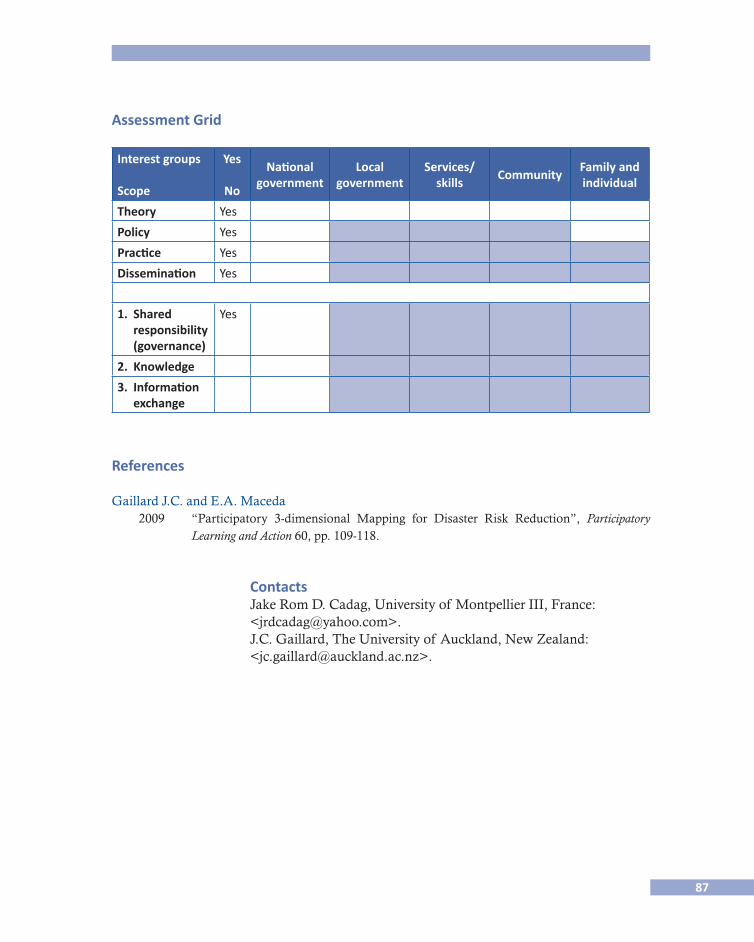
87
Assessment Grid
Interest groups
Scope
Yes
No
Nationalgovernment
Localgovernment
Services/skills
CommunityFamily and individual
Theory Yes
Policy Yes
Practice Yes
Dissemination Yes
1. Shared responsibility (governance)
Yes
2. Knowledge
3. Information exchange
References
Gaillard J.C. and E.A. Maceda 2009 “Participatory 3-dimensional Mapping for Disaster Risk Reduction”, Participatory
Learning and Action 60, pp. 109-118.
Contacts Jake Rom D. Cadag, University of Montpellier III, France: <[email protected]>. J.C. Gaillard, The University of Auckland, New Zealand: <[email protected]>.


89
CASOS LATINOAMERICANOS
LATIN AMERICAN CASES

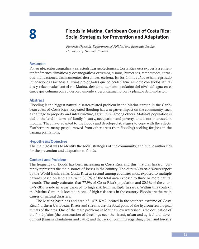
91
8 Floods in Matina, Caribbean Coast of Costa Rica: Social Strategies for Prevention and Adaptation
Florencia Quesada, Department of Political and Economic Studies, University of Helsinki, Finland
ResumenPor su ubicación geográfica y características geotectónicas, Costa Rica está expuesta a enfren-tar fenómenos climáticos y oceanográficos extremos, sismos, huracanes, tempestades, torna-dos, inundaciones, deslizamientos, derrumbes, etcétera. En los últimos años se han registrado inundaciones asociadas a lluvias prolongadas que coinciden generalmente con suelos satura-dos y relacionadas con el río Matina, debido al aumento paulatino del nivel del agua en el cauce que culmina con su desbordamiento y desplazamiento por la planicie de inundación.
AbstractFlooding is the biggest natural disaster-related problem in the Matina canton in the Carib-bean coast of Costa Rica. Repeated flooding has a negative impact on the community, such as damage to property and infrastructure, agriculture, among others. Matina’s population is tied to the land in terms of family, history, occupation and poverty, and is not interested in moving. They have adapted to the floods and developed strategies to cope with the effects. Furthermore many people moved from other areas (non-flooding) seeking for jobs in the banana plantations.
Hypothesis/ObjectiveThe main goal was to identify the social strategies of the community, and public authorities for the prevention and adaptation to floods.
Context and ProblemThe frequency of floods has been increasing in Costa Rica and this “natural hazard” cur-rently represents the main source of losses in the country. The Natural Disaster Hotspot report by the World Bank, ranks Costa Rica as second among countries most exposed to multiple hazards based on land area, with 36.8% of the total area exposed to three or more natural hazards. The study estimates that 77.9% of Costa Rica’s population and 80.1% of the coun-try’s gdp reside in areas exposed to high risk from multiple hazards. Within this context, the Matina Canton is located in one of high-risk areas in the country. Floods are the main causes of natural disasters.
The Matina basin has and area of 1475 Km2 located in the southern extreme of Costa Rica Northern Caribbean. Rivers and streams are the focal point of the hydrometeorological threats of the area. One of the main problems in Matina’s low watershed is the occupation of the flood plains (the construction of dwellings near the rivers), urban and agricultural devel-opment (banana plantations and cattle) and the lack of planning regarding urban and forestry
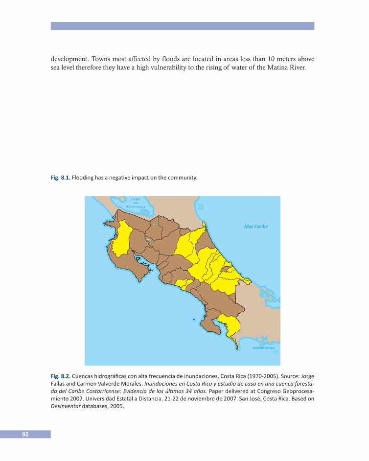
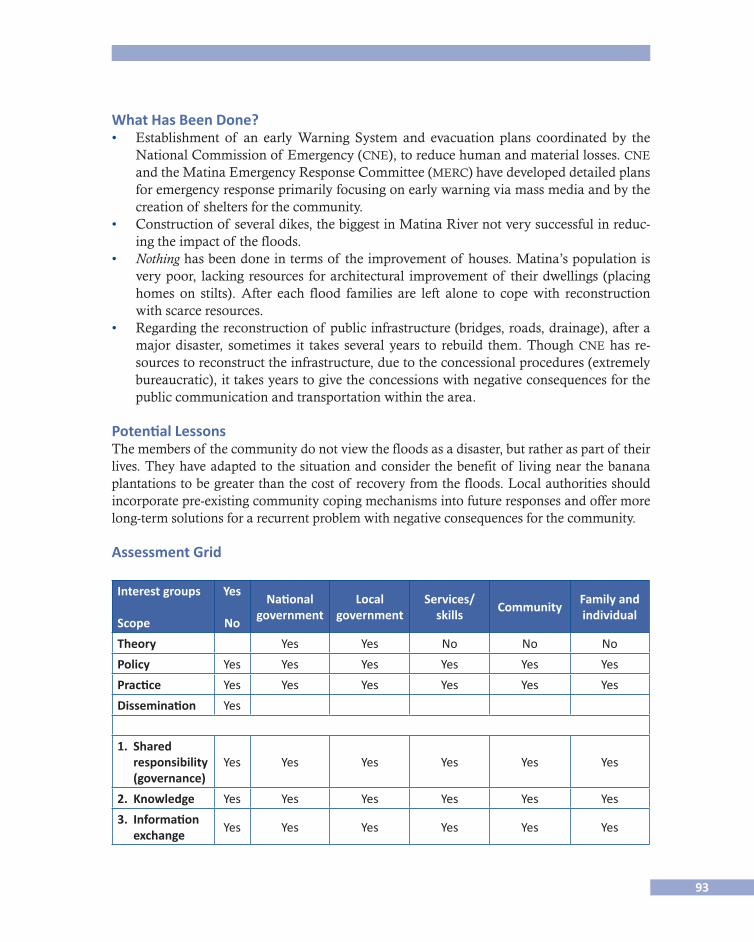
93
What Has Been Done?• Establishment of an early Warning System and evacuation plans coordinated by the
National Commission of Emergency (cne), to reduce human and material losses. cne and the Matina Emergency Response Committee (merc) have developed detailed plans for emergency response primarily focusing on early warning via mass media and by the creation of shelters for the community.
• Construction of several dikes, the biggest in Matina River not very successful in reduc-ing the impact of the floods.
• Nothing has been done in terms of the improvement of houses. Matina’s population is very poor, lacking resources for architectural improvement of their dwellings (placing homes on stilts). After each flood families are left alone to cope with reconstruction with scarce resources.
• Regarding the reconstruction of public infrastructure (bridges, roads, drainage), after a major disaster, sometimes it takes several years to rebuild them. Though cne has re-sources to reconstruct the infrastructure, due to the concessional procedures (extremely bureaucratic), it takes years to give the concessions with negative consequences for the public communication and transportation within the area.
Potential LessonsThe members of the community do not view the floods as a disaster, but rather as part of their lives. They have adapted to the situation and consider the benefit of living near the banana plantations to be greater than the cost of recovery from the floods. Local authorities should incorporate pre-existing community coping mechanisms into future responses and offer more long-term solutions for a recurrent problem with negative consequences for the community.
Assessment Grid
Interest groups
Scope
Yes
No
Nationalgovernment
Localgovernment
Services/skills
CommunityFamily and individual
Theory Yes Yes No No No
Policy Yes Yes Yes Yes Yes Yes
Practice Yes Yes Yes Yes Yes Yes
Dissemination Yes
1. Shared responsibility (governance)
Yes Yes Yes Yes Yes Yes
2. Knowledge Yes Yes Yes Yes Yes Yes
3. Information exchange
Yes Yes Yes Yes Yes Yes
94
References
Fallas, Jorge and Carmen Valverde Morales 2007 “Inundaciones en Costa Rica y estudio de caso en una cuenca forestada del Caribe
Costarricense: Evidencia de los últimos 34 años.” Paper delivered at Congreso Geoproc�esamiento 2007, november, San José, Costa Rica, Universidad Estatal a Distancia, pp. 21-22.
Gallardo, Daniel (coord.) 2008 “Costa Rica Financing disaster risk reduction, Sistema Nacional de Prevención de
Riesgos y Atención de Emergencias (snprae)”, in un/isdr, Towards National Resil�ience: Good practices of National Platforms for Disaster Risk Reduction, Geneva, Switzer-land, United Nations secretariat of the International Strategy for Disaster Reduction (un/isdr), pp. 13-19.
Gobierno de Costa Rica 2010 Plan Nacional para la Gestión del Riesgo 2010�2015. Marco estratégico para la aplicación de
la política de Gestión del Riesgo, San José, Costa Rica, Departamento de Planificación.Ibarra Turcios, Ángel María 2005 “Centro América: Una región de múltiples amenazas y alta vulnerabilidad”, en Ar-
mando Fernández (comp.), Comarcas Vulnerables: Riesgos y Desastres Naturales en Cen�troamérica y el Caribe, Buenos Aires, Editorial cries, p. 105.
Lavell, Allan 1995 “Inundaciones: La costa Atlántica de Costa Rica. Algunas reflexiones sobre la inves-
tigación social y el manejo de desastres”, en Desastres y Sociedad, no. 5, Año 3, julio-diciembre, pp. 1-5.
Tulane University School of Public Health Students 2007 “Risk Perception Assessment of Natural Hazards”, in the Compiled by the students of
the Tulane University School of Public Health and Tropical Medicine Payson Center for International Development and Information Technology Transfer as a case study for Di-saster Management in the Latin American Setting, July 26, Costa Rica, pdf document.
World Bank 2010 Disaster Risk Management in Latin America and the Caribbean Region: gfdrr Country
Notes, Costa Rica, Washington, gfdrr.
<http://www.cne.go.cr/>. <http://www.desenredando.org/>. <http://online.desinventar.org/>. <http://www.unisdr.org/eng/library/lib-index.htm>.
Contact Florencia Quesada, University of Helsinki: <[email protected]>.
95
9 Adaptación de la vivienda vernácula a los climas en México
Joel F. Audefroy, esia-tec, Instituto Politécnico Nacional, México
ResumenEste artículo intenta mostrar que la vivienda vernácula en México es el producto de diferen-tes procesos de adaptación a fenómenos hidrometeorológicos. En este breve trabajo vamos a considerar los procesos de adaptación en el campo de la arquitectura vernácula y la tecnolo-gía constructiva por sociedades llamadas “tradicionales”, es decir comunidades que han pro-ducido su hábitat a partir de tradiciones, culturas y mitos desde épocas remotas y que han sobrevivido hasta nuestros días. El clima es un factor modificante pero no es el único. Los trabajos de edificación de vivienda vernácula se realizan sin arquitectos pero con una intensa mano de obra que exige planeación, organización, conocimiento sistematizado del clima y de la tecnología y de una red de especialistas y artesanos en diferentes ramos. Estos trabajos que todavía podemos observar, implicaron invención, innovación y adaptación así como la transmisión oral de conocimientos para ubicar y orientar la vivienda, preparar el terreno, buscar y preparar los materiales de construcción, edificar y llevar a cabo los rituales de cons-trucción. Existen varias formas de adaptación, entre ellas la forma, el diseño, los materiales y la tecnología utilizada. Se revisan aquí los procesos de adaptación de la vivienda a precipita-ciones, huracanes, inundaciones, al clima seco-estepario y al manejo y control del agua.
AbstractThis article attempts to show that vernacular housing in Mexico is the product of different processes to adapt to weather phenomena. In this short paper we consider the processes of adaptation in the field of vernacular architecture and construction technology by societies called “traditional”, i.e. communities that have produced their habitat from traditions, cul-tures and myths from ancient times and that have survived until today. The climate is a modifying factor but not the only factor modifier. The housing construction work performed without architects but with a labor-intensive that requires planning, organization, systemat-ic knowledge of climate and technology and a network of specialist craftsmen in different fields. The work that we can still see, involved invention, innovation and adaptation as well as the oral transmission of knowledge to locate and guide the house, preparing the ground, find and prepare materials for construction, building and conducting rituals construction. There are several forms of adaptation, including the shape, design, materials and technolo-gy used. We review here the processes of adapting housing to rainfall, hurricanes, floods, dry-steppe climate and the management and control of water.
96
IntroducciónLas sociedades y los grupos humanos hicieron frente a los impactos de los fenómenos rela-cionados con el tiempo y el clima desde tiempos antiguos (ipcc, 2007). El mismo reporte del Grupo Intergubernamental de expertos subraya que “la capacidad adaptativa está ínti-mamente relacionada con el desarrollo social y económico, aunque se halla desigualmente distribuida tanto entre las sociedades como en el seno de éstas”. Si bien esta capacidad se relaciona con el desarrollo social y económico, existen otros factores que han permitido el desarrollo de procesos adaptativos en el seno de las sociedades tradicionales. En este breve estudio de caso vamos a considerar los procesos de adaptación en el campo de la arquitectu-ra vernácula y la tecnología constructiva por sociedades llamadas “tradicionales”, es decir comunidades que han producido su hábitat a partir de tradiciones, culturas y mitos desde épocas remotas y cuyas culturas han sobrevivido hasta nuestros días.
Encontramos los fundamentos teóricos a los planteamientos relativos al clima y a los procesos de adaptación de la vivienda vernácula, principalmente en tres autores. El primero, Amos Rapoport (1969) quien fue el primero en considerar el clima como factor modificante de la vivienda vernácula; el segundo, Paul Oliver (1978) quien reveló la necesidad de un nuevo enfoque sobre la vivienda vernácula en su trabajo titulado Cobijo y sociedad, y, más tarde en 2003, en Dwellings donde un capítulo entero trata de la adaptación al clima (“Co-ping with climate”). El tercero es la arquitecta Valeria Prieto, quién llevó a cabo el primer estudio de importancia sobre la vivienda vernácula en México en 1978, con el libro titulado Vivienda campesina en México.
Rapoport está constantemente asombrado por el conocimiento y habilidad de los cons-tructores para elegir los sitios y los materiales adaptados al clima y para adaptar el modelo tradicional a las condiciones micro-locales del clima. Las condiciones necesarias por la tra-dición para el lugar y la forma han sido, a veces, basadas en un motivo de orden climático. En el campo de la arquitectura, existe la teoría constantemente sostenida de la causalidad del clima y la de que los requerimientos del clima determinan la forma. Rapoport cuestiona esta opinión muy común, pero menciona el papel determinante del clima en la creación de la forma construida, y a la vez reconoce que el papel de la cultura es, en numerosos casos, más importante que el clima y por lo tanto cuestiona así toda opinión determinista extrema. La existencia de soluciones formales y constructivas no-climáticas conduce a cuestionar las opiniones más extremas en relación con el determinismo climático y conduce a pensar que existen otras razones. Sin embargo, la existencia de soluciones adaptativas al clima en las sociedades tradicionales confirma que si bien el clima no es determinante, es más bien un factor modificante.
Paul Oliver (1978) recalca que en los estudios modernos la “construcción primitiva” per-manece como el arquetipo absoluto y sus formas se interpretan como precursoras de la arqui-tectura de las grandes sociedades llamadas “civilizadas”, cuando son el producto de una cultura y de una adaptación al clima. Este arquetipo está claramente ligado al concepto del “hombre primitivo” y por supuesto su construcción es “primitiva”. Se han necesitado varias décadas para, por fin, salir de estos conceptos, verdaderos candados a la investigación cientí-fica en el campo de la arquitectura. El reconocimiento de la existencia misma de unas formas
97
constructivas destinadas a usos domésticos, llamada ahora “arquitectura vernácula”, suscep-tibles de diferenciarse según las culturas, el medio ambiente y el clima del lugar ha sido un largo camino que podemos fechar más o menos a partir de la segunda mitad del siglo xx. En el capítulo titulado “Coping with climate”, P. Oliver (2003) reconoce que el clima modifica la concepción de algunas edificaciones, el problema es saber hasta qué punto se puede com-probar el éxito o el fracaso de tal respuesta ya que muy pocas construcciones tradicionales han sido objeto de investigaciones científicas para determinar dichos éxitos o fracasos.
Valeria Prieto (1978), por su parte considera que las condiciones climáticas conforman una de las principales razones de ser de la vivienda. Precisa que milenios de saber popular han ido mejorando los diseños de las viviendas para adaptarlos a cada clima. El conoci-miento local ha ido enriqueciéndose poco a poco, por lo tanto, el proceso de adaptación al clima no es el fruto de una decisión repentina, sino más bien el fruto de un largo proceso de ensayos y errores.
El clima es, entonces, un factor modificante pero que ha sido a lo largo del tiempo el fruto de un proceso de ensayos y errores. En este contexto surge la importancia de los cons-tructores, los detentores del saber hacer (que generalmente no son arquitectos) que han lo-grado adaptar poco a poco las viviendas a los climas más extremosos.
México está divido por el Trópico de Cáncer y por lo tanto el clima y la temperatura va-rían entre un clima templado y seco arriba del trópico y tropical lluvioso abajo del trópico con temperaturas medias de 15°C en la zona templada y 22.5°C en la zona tropical. Tam-bién el clima varía según la altitud: en las regiones localizadas a menos de mil metros sobre el nivel del mar, la temperatura está determinada por la latitud. Así, encontramos tres gran-des tipos de climas: el tropical lluvioso que abarca las costas del sur del Trópico de Cáncer, el templado que cubre las sierras madre Oriental y Occidental y los valles centrales y, final-mente el clima seco que abarca las zonas bajas al norte del Trópico de Cáncer. Estos tres grandes climas inducen a soluciones diversas en la vivienda vernácula.
Las precipitaciones abarcan un ciclo de verano de junio a septiembre que va desde los 300 mm en la zona semidesértica a 1500 mm en los declives de la sierra. Los fenómenos hi-drometeorológicos en México van desde la depresión tropical con vientos menores a 61km/h; la tormenta tropical con vientos entre 61 km/h y 113 km/h; hasta los huracanes1 llamados ciclones tropicales con vientos de más de 114 km/h, principalmente en las costas. Lluvias tropicales y tormentas provocan a menudo inundaciones sobre todo en las zonas cercanas a ríos y zonas lacustres. También existen fenómenos como las sequías que, a dife-rencia de otros fenómenos meteorológicos en aspectos temporales, son a menudos inciertos y su duración puede ser relativamente prolongada. Varias sequías largas han sido registradas a lo largo de la historia de México (M.E. Hernández Cerda, 2007; García Acosta, 2003), principalmente en el norte y centro del país.
1 La palabra huracán proviene de la palabra maya hunraken que significa “dios de las tormentas”, y también de
la palabra urican que significa viento fuerte entre los habitantes indígenas de algunas islas del Caribe (Fuente:
María Engracia Hernández Cerda, 2001).

98
Los trabajos de edificación de viviendas se realizaron con una intensa mano de obra que exigió planeación, organización, conocimiento sistematizado del clima y de la tecnología y de una red de especialistas y artesanos en diferentes ramos. Estos trabajos implicaron inven-ción, innovación y adaptación así como la transmisión oral de conocimientos para ubicar y orientar la vivienda, preparar el terreno, buscar, fabricar y preparar los materiales de cons-trucción, edificar y llevar a cabo los rituales de construcción. Predominan los materiales ve-getales y minerales, generalmente materiales locales encontrados en el lugar que requieren más de mano de obra que de inversión monetaria.
Adaptación a las precipitaciones y huracanesDesde la época prehispánica los habitantes del territorio mesoamericano padecían de los fe-nómenos llamados huracanes o ciclones tropicales. El dios de la lluvia “Tlaloc” aparece bajo una forma u otra en todas las culturas mesoamericanas, desde la olmeca del horizonte Preclásico hasta la maya del horizonte Clásico. En el estado de Yucatán y en la zona maya, el huracán fue protagonista de mitos cosmogónicos así como de su religión y de sus rituales calendáricos. De ahí los mitos se extendieron por el norte y el sur doquiera que hubo torna-dos, tolvaneras, torbellinos y trombas (Ortiz, 1947).
Es interesante la observación de Bartolomé de Las Casas en su Apologética historia suma�ria que “las casas de los indios, entramadas con bexuco, o sean los bohíos, se mantenían más firmes contra los huracanes que las hechas por los españoles con tablas y engalabernadas con clavos”. Esto muestra una temprana estrategia de adaptación tecnológica a los huraca-nes por los mismos indígenas caribeños. Cabe destacar que las culturas prehispánicas que principalmente fueron afectadas por los ciclones tropicales se ubicaban en las costas del Golfo de México, como los totonacas y del Mar Caribe, como los mayas. Los totonacas de lo que hoy es el estado de Veracruz, mostraban conocimientos de diversas ciencias, como lo muestra la pirámide de los nichos en El Tajín. Esta última palabra significa en totonaca “dios del trueno, rayo o huracán”. En varios edificios del conjunto El Tajín fueron construi-das grecas escalonadas de forma espiral que representan el ojo del huracán con el nombre de Tajín.
Coincide que las zonas tropicales lluviosas son generalmente expuestas a huracanes. Sin embargo, para ser más frescas, las viviendas están orientadas a los vientos dominantes. Las puertas se colocan opuestas a fin de obtener una ventilación cruzada. En caso de huracán se cierran las puertas para evitar que el viento entre en la casa y levante el techo. En este clima tropical lluvioso es necesario un techo que permita un escurrimiento rápido del agua de llu-via: los techos de las casas totonacas o de la cuenca del Papaloapan, Veracruz, se hacen muy inclinados de dos o cuatro aguas. Cuando los techos son de paja, zacate, palma o tejamanil la pendiente es fuerte (más de 45°) y los aleros son amplios para proteger los muros de la ero-sión del agua de lluvia. En algunos casos se abren huecos a la altura de la cumbrera para permitir la salida del aire caliente acumulado en la parte superior de la casa (V. Prieto, 1978). Lo que protege las viviendas de los huracanes son principalmente las plantaciones vegetales: siempre la casa totonaca o de la cuenca del Papaloapan está rodeada de planta-ciones: palmeras, bambú, platanales, etcétera. La palma tiene una extrema resistencia al

99
viento, es un árbol que se dobla pero no se rompe fácilmente. Rara vez la casa totonaca está ubicada en la cima de un monte, general-mente se localiza en la parte baja de un relieve con el fin de recibir lo menos posible los efectos de un huracán (véase la figura 9.1).
En Cosoleacaque, Veracruz, la casa nahua es más pequeña y rectangular con techo de cuatro aguas de palma, las esquinas de los muros de bahareque están redondeadas. Nótese que estas casas es-tán rodeadas del bosque tropical protegidas así de los huracanes (véase la figura 9.2).
En el estado de Yucatán la casa tiene un diseño que permite a la vez recibir lluvias tropicales, calor húmedo y huracanes. El techo de cuatro aguas esta redondeado en forma absidal en ambos lados con el fin de ofrecer la menos resistencia posible al viento (véase la figu-ra 9.3). La altura del techo permite acumular el aire caliente en las partes altas mientras se puede disfrutar de un aire más fresco en las partes bajas. También hay que observar que la casa tradicional maya nunca está construida en la orilla del mar donde los huracanes son más intensos, sino en lugares rodeados de árboles.
Adaptación a inundacionesMéxico ha sido desde épocas remotas el terreno de lluvias intensas e inundaciones. En 1998 y 1999, México, como otros países padecie-ron del fenómeno del niño con lluvias torrenciales que provocaron inundaciones. Este fenómeno no es nuevo. En la historia de México, numerosas precipitaciones han ocurrido. Un estudio llevado a cabo por el ciesas2 ha registrado fenómenos de sequías e inundaciones desde la época prehispánica hasta el final del siglo xix.3 En este con-texto los habitantes de Mesoamérica han tenido que adaptar sus vi-viendas a inundaciones recurrentes, sobre todo los que viven en zonas con altas precipitaciones que corresponden a las zonas del tró-pico húmedo. Las inundaciones se dan más frecuentemente en las orillas de ríos cuyas riberas están ocupadas por asentamientos huma-nos. Las inundaciones se han clasificado en dos tipos. El primero es aquel que ocurre en las áreas costeras cuando una tormenta intensa o huracán aumenta el nivel del mar un metro o más y provoca la inundación repentina de las regiones costeras bajas; este fenómeno se denomina surgencia de tormenta. El segundo tipo se presenta cuan-do gran cantidad de agua escurre hacia un río provocando que su nivel aumente y rompa el bordo; este fenómeno es producido por
2 Centro de Investigaciones y Estudios Superiores en Antropología Social, México, DF.3 Véase Desastres Agrícolas en México, 2003.
Fig. 9.1. Casa totonaca, con techo de palma y muros de bambú rajado por la mitad en Ojital, Veracruz (foto: Mariana Yampolsky, 1982).
Fig. 9.2. Casa nahua en Cosoleacaque, Veracruz (foto: Mariana Yampols-ky, 1993).
Fig. 9.3. Casa maya en Yucatán. El alto techo in-clinado permite a la vez un escurrimiento rápido de la lluvia y los lados redondeados limitan la resistencia a los vientos (foto del autor).
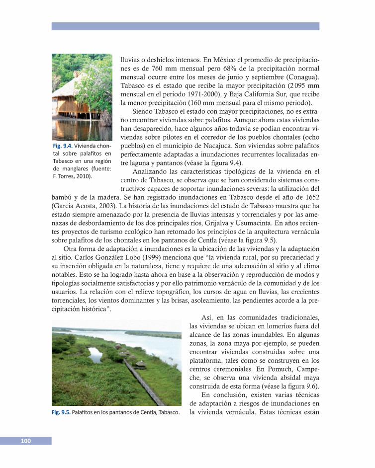
100
lluvias o deshielos intensos. En México el promedio de precipitacio-nes es de 760 mm mensual pero 68% de la precipitación normal mensual ocurre entre los meses de junio y septiembre (Conagua). Tabasco es el estado que recibe la mayor precipitación (2 095 mm mensual en el periodo 1971-2000), y Baja California Sur, que recibe la menor precipitación (160 mm mensual para el mismo periodo).
Siendo Tabasco el estado con mayor precipitaciones, no es extra-ño encontrar viviendas sobre palafitos. Aunque ahora estas viviendas han desaparecido, hace algunos años todavía se podían encontrar vi-viendas sobre pilotes en el corredor de los pueblos chontales (ocho pueblos) en el municipio de Nacajuca. Son viviendas sobre palafitos perfectamente adaptadas a inundaciones recurrentes localizadas en-tre laguna y pantanos (véase la figura 9.4).
Analizando las características tipológicas de la vivienda en el centro de Tabasco, se observa que se han considerado sistemas cons-tructivos capaces de soportar inundaciones severas: la utilización del
Fig. 9.4. Vivienda chon-tal sobre palafitos en Tabasco en una región de manglares (fuente: F. Torres, 2010).
Fig. 9.5. Palafitos en los pantanos de Centla, Tabasco.
bambú y de la madera. Se han registrado inundaciones en Tabasco desde el año de 1652 (García Acosta, 2003). La historia de las inundaciones del estado de Tabasco muestra que ha estado siempre amenazado por la presencia de lluvias intensas y torrenciales y por las ame-nazas de desbordamiento de los dos principales ríos, Grijalva y Usumacinta. En años recien-tes proyectos de turismo ecológico han retomado los principios de la arquitectura vernácula sobre palafitos de los chontales en los pantanos de Centla (véase la figura 9.5).
Otra forma de adaptación a inundaciones es la ubicación de las viviendas y la adaptación al sitio. Carlos González Lobo (1999) menciona que “la vivienda rural, por su precariedad y su inserción obligada en la naturaleza, tiene y requiere de una adecuación al sitio y al clima notables. Esto se ha logrado hasta ahora en base a la observación y reproducción de modos y tipologías socialmente satisfactorias y por ello patrimonio vernáculo de la comunidad y de los usuarios. La relación con el relieve topográfico, los cursos de agua en lluvias, las crecientes torrenciales, los vientos dominantes y las brisas, asoleamiento, las pendientes acorde a la pre-cipitación histórica”.
Así, en las comunidades tradicionales, las viviendas se ubican en lomeríos fuera del alcance de las zonas inundables. En algunas zonas, la zona maya por ejemplo, se pueden encontrar viviendas construidas sobre una plataforma, tales como se construyen en los centros ceremoniales. En Pomuch, Campe-che, se observa una vivienda absidal maya construida de esta forma (véase la figura 9.6).
En conclusión, existen varias técnicas de adaptación a riesgos de inundaciones en la vivienda vernácula. Estas técnicas están
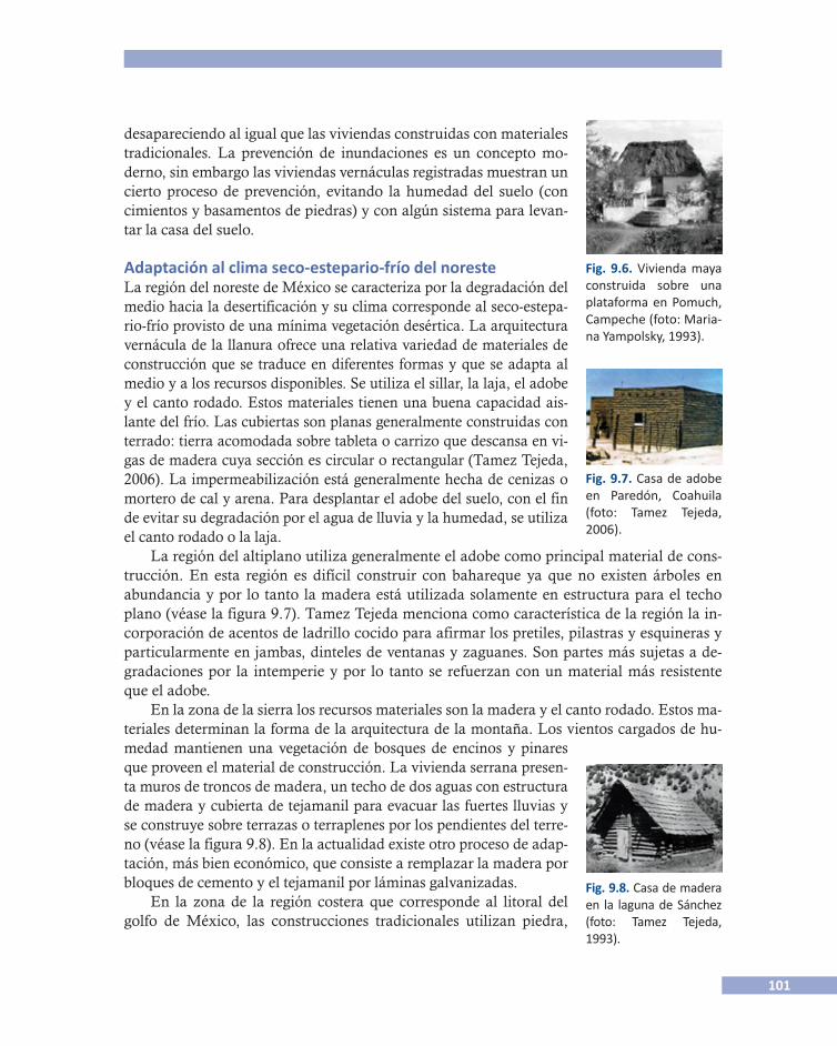
101
desapareciendo al igual que las viviendas construidas con materiales tradicionales. La prevención de inundaciones es un concepto mo-derno, sin embargo las viviendas vernáculas registradas muestran un cierto proceso de prevención, evitando la humedad del suelo (con cimientos y basamentos de piedras) y con algún sistema para levan-tar la casa del suelo.
Adaptación al clima seco-estepario-frío del noresteLa región del noreste de México se caracteriza por la degradación del medio hacia la desertificación y su clima corresponde al seco-estepa-rio-frío provisto de una mínima vegetación desértica. La arquitectura vernácula de la llanura ofrece una relativa variedad de materiales de construcción que se traduce en diferentes formas y que se adapta al medio y a los recursos disponibles. Se utiliza el sillar, la laja, el adobe y el canto rodado. Estos materiales tienen una buena capacidad ais-lante del frío. Las cubiertas son planas generalmente construidas con terrado: tierra acomodada sobre tableta o carrizo que descansa en vi-gas de madera cuya sección es circular o rectangular (Tamez Tejeda, 2006). La impermeabilización está generalmente hecha de cenizas o mortero de cal y arena. Para desplantar el adobe del suelo, con el fin de evitar su degradación por el agua de lluvia y la humedad, se utiliza el canto rodado o la laja.
Fig. 9.7. Casa de adobe en Paredón, Coahuila (foto: Tamez Tejeda, 2006).
Fig. 9.8. Casa de madera en la laguna de Sánchez (foto: Tamez Tejeda, 1993).
Fig. 9.6. Vivienda maya construida sobre una plataforma en Pomuch, Campeche (foto: Maria-na Yampolsky, 1993).
La región del altiplano utiliza generalmente el adobe como principal material de cons-trucción. En esta región es difícil construir con bahareque ya que no existen árboles en abundancia y por lo tanto la madera está utilizada solamente en estructura para el techo plano (véase la figura 9.7). Tamez Tejeda menciona como característica de la región la in-corporación de acentos de ladrillo cocido para afirmar los pretiles, pilastras y esquineras y particularmente en jambas, dinteles de ventanas y zaguanes. Son partes más sujetas a de-gradaciones por la intemperie y por lo tanto se refuerzan con un material más resistente que el adobe.
En la zona de la sierra los recursos materiales son la madera y el canto rodado. Estos ma-teriales determinan la forma de la arquitectura de la montaña. Los vientos cargados de hu-medad mantienen una vegetación de bosques de encinos y pinares que proveen el material de construcción. La vivienda serrana presen-ta muros de troncos de madera, un techo de dos aguas con estructura de madera y cubierta de tejamanil para evacuar las fuertes lluvias y se construye sobre terrazas o terraplenes por los pendientes del terre-no (véase la figura 9.8). En la actualidad existe otro proceso de adap-tación, más bien económico, que consiste a remplazar la madera por bloques de cemento y el tejamanil por láminas galvanizadas.
En la zona de la región costera que corresponde al litoral del golfo de México, las construcciones tradicionales utilizan piedra,
102
adobe o sillar o bien la combinación de éstas en los muros exteriores. Las divisiones inte-riores se hacen con embarro sobre estructura de madera y las cubiertas están hechas de palma colocada sobre una estructura de hor-cones y los aleros están cuidadosamente re-cortados (véase la figura 9.9).
Adaptación al clima desérticoLa región del noroeste incluye la península
Fig. 9. 10. Vista de Paquimé, Chihuahua (foto del autor).
Fig. 9.9. Casa de adobe y palma en Soto La Marina (foto: Tamez Tejeda, 2006).
de Baja California y los estados de Sonora y Chihuahua. La utilización de la tierra como principal material de construcción se puede rastrear desde la época prehispánica, como en el sitio arqueológico de Paquimé (Casas Grandes) en el estado de Chihuahua (véase la figu-ra 9.10). Esta utilización de la tierra en el hábitat muestra un aprovechamiento máximo de los recursos existentes en la región y una adaptación significativa del hombre al ambiente (Sandra Cruz Flores, 2007) así como el conocimiento de sus propiedades térmicas. El clima extremoso de la región obligó a los pobladores a buscar sitios que ofrecieran el mayor res-guardo entre los agentes ambientales: vientos helados, fuertes y prolongadas nevadas en in-vierno con temperaturas de varios grados bajo cero, y en verano insolación extrema y escasas lluvias.
Estos sitios de casas en acantilado tales como los de las Cuarenta Casas, Chihuahua, emplearon simultáneamente diversas técnicas de construcción tales como el encofrado (o tierra apisonada), el bahareque y técnicas mixtas con madera y dieron resultados satisfacto-rios con los comportamientos térmicos frente a las condiciones externas del ambiente.
En el estado de Sonora y en el Valle del Yaqui encontramos diferentes grupos indígenas tales como los seris, opatas, pimas, mayos y yaquis que han luchado por conservar su identi-dad hasta nuestro tiempo. F. López Morales (1993) describe la casa yaqui y resalta un sutil proceso de adaptación al clima extremoso: los muros están hechos de un entramado de ra-mas y palos que generalmente son de pitahaya y de mezquite. En el verano las horas de ma-yor calor llegan hasta los 45 y 50°C. A la sombra de la casa se viven las horas de mayor calor, beneficiándose de la ventilación natural a través de los muros vegetales. En el invier-
no, al contrario, los muros exteriores se pro-tegen con petates, evitando que el frío penetre a través del entramado de ramas.
En la península de Baja California el cli-ma es seco y cálido la mayor parte del año, las lluvias son escasas y prevalece el medio desértico. Las viviendas tradicionales son sumamente ligeras, están hechas con esteras tejidas de zacate o bejuco. Se utiliza un pór-tico para proteger la fachada principal de la radiación solar y proporciona un espacio en
103
el que se puede estar al aire libre y a la som-bra. A veces se usa para dormir en hamacas durante la época de calor (figura 9.11).
Como consecuencia del clima seco, los techos son planos, generalmente altos con el fin de presentar la menor superficie perpen-dicular a los rayos del sol y almacenar sufi-ciente aire en el interior de la vivienda. Los techos están hechos de materiales de baja conductividad térmica. En algunas regiones el techo es abovedado. Son frecuentes los te-chos de terrado sobre carrizos y vigas apoya-dos sobre muros de adobe. Los muros de
Fig. 9.11. Casa en Baja California, hecha de estera tejida (foto del autor).
adobe son una respuesta al calor y pueden tener hasta un metro de espesor. Acumulan el ca-lor en el día y lo restituyen en la noche que es generalmente fría. Las ventanas son escasas y reducidas y con frecuencia van cerradas y llevan postigo interior y exterior para ocultar la entrada del sol, el calor radiante y las tolvaneras frecuentes en zonas áridas.
Discusión y conclusiones: para entender la relación hábitat/climaEl hábitat no controla el clima, sin embargo puede controlar y modificar el clima interior aun si está afectado por un clima exterior adverso. ¿Cómo puede el hábitat controlar el cli-ma interior? Para este propósito tiene varios recursos: los materiales utilizados, la forma o el diseño, y los servicios y sistemas anexos a la vivienda (como reja de ventilación por ejem-plo). Cuando hablamos de adaptación al clima, nos referimos a una acción sobre el clima interior de la vivienda. Esto implica una distinción clara entre el espacio interior y el espacio exterior. En algunas sociedades, en particular en el medio tropical húmedo, esta distinción no es tan clara. El habitante vive en el exterior, el patio es su sala de estar, la cocina está cer-cana pero exterior, el pórtico es su espacio de descanso, donde coloca una hamaca. Sólo de noche entra en la casa para dormir.
A esta distinción entre espacio interior y espacio exterior, el espacio interior sería el espa-cio modificado/controlado en términos de clima; el espacio exterior sería el clima no contro-lado. Existen otros conceptos que nos pueden aportar interpretaciones a la relación del hábitat con el clima. El concepto de límite, por ejemplo, permite calificar el espacio: el espa-cio adaptado (interior) y el espacio no adaptado (exterior). Hemos visto que el hábitat tiene prolongaciones al exterior, y que la casa es a la vez el espacio interior (dormitorio) y el espa-cio exterior (sala de estar). A veces esta noción de límite permite distinguir entre el espacio profano y el espacio sagrado que fue abordado por varios autores tales como Mircea Eliade (1979), Leroi-Gourhan (1978), Jean-Paul Lebeuf (1961), y Levy-Strauss (1958). En México, el espacio sagrado puede ser exterior (monte sagrado tzotzil, altar otomí), o interior (casa de los dioses de los huicholes), pero cada vez indica un espacio que ha sido modificado o no en relación con el clima. A veces el clima puede ser modificado, ya no por el hábitat, sino por una ceremonia ritual, tal como en la ceremonia huichol del peyote, en donde el “abuelo”
104
fuego protege a los participantes del frio de la noche. Estamos entonces en un espacio sagra-do modificado por el fuego, del cual sólo se puede salir pidiendo permiso. Cuando el partici-pante sale de los límites del círculo sagrado siente el frio de la noche y encuentra de nuevo el clima no modificado en el espacio profano.4
Otro concepto que nos permite entender la relación hábitat/clima es el de orientar. En todas las sociedades existe este concepto. Las sociedades mesoamericanas se orientan posi-cionándose frente al oeste, teniendo el norte a la derecha y el sur a la izquierda, contraria-mente a la manera europea que se posiciona frente al norte (los mapas están orientados con el norte arriba). En el bosque tropical, el bosque de niebla, la forma de orientarse es a partir de los ríos que permiten al cazador ubicarse y encontrar su camino. Se trata de una orienta-ción hidrográfica en oposición a la orientación cardinal de los pueblos del desierto y del alti-plano. Entender esto es fundamental para entender cómo se ubican las viviendas en el bosque tropical, en relación con el río, y en el desierto o el altiplano.
La orientación de las casas depende de la concepción misma del espacio (véase J. Audefroy, 1983). El sitio geomántico corresponde al sitio geográfico, como lo precisa Pézeu-Masabuau (1981) para la casa japonesa. Según el clima, predomina un elemento, el levantamiento del sol en el desierto, el eje del río en el bosque tropical. Otra forma de adaptación es lo que po-dríamos llamar la adaptación exógena, cuando el medio social y cultural está cambiando. La introducción de la llamada “modernidad” en la vivienda tradicional ha cambiado mate-riales, sistemas constructivos y formas y hasta modos de vida. Esta forma de adaptación se efectúa de tres maneras (según F. Paul-Levy y Marion Segaud, 1983):
• Los habitantes modifican el espacio “moderno”, la sala se transforma en dormitorio, cuando la vivienda no está prevista para numerosos hijos.
• Los habitantes modifican su modo de vida y adoptan las costumbres occidentales con menos hijos.
• La vivienda tradicional se transforma poco a poco, hasta utilizar materiales y técnicas de construcción modernos y hasta que su forma y aspecto desaparezcan por completo.
Esta observación conduce a plantear la pregunta siguiente: ¿Por qué estos procesos de adaptación al clima y las soluciones tradicionales no han sido retomados en las construcciones de viviendas modernas? Aquí interviene el papel del mercado de la construcción y de la forma misma de la producción de la vivienda, cuya forma moderna es incompatible con la forma de producción de la vivienda tradicional más ligada a procesos culturales y a cadenas de saber que ignoran el papel del mercado y de la industrialización de los procesos constructivos.
4 Además los efectos del peyote aumentan esta sensación de calor/sagrado y frío/profano.

105
Referencias
Audefroy, Joel 1983 Le príncipe d”Ometeotl, architectures indiennes au Mexique, Tesis de doctorado, Paris VII,
bajo la dirección de Robert Jaulin. 2005 “La arquitectura vernácula en el grabado mexicano, Esencia y Espacio”, Nueva Época,
núm. 21, Año 2, julio-septiembre, Estado de México, esia Tecamachalco.Bahamon, Alejandro et al. 2009 Palafito de arquitectura vernácula a contemporánea, Barcelona, pad.Cruz Flores, Sandra 2007 Estructuras arqueológicas del tipo casas en acantilado en el estado de Chihuahua, Luis Fernan-
do Guerrero (coord.), Patrimonio construido con tierra, pp. 31-46.García Acosta, Virginia, Juan Manuel Pérez Zevallos y América Molina Del Villar 2003 Desastres Agrícolas en México. Catálogo Histórico, México, Fondo de Cultura Económica/
ciesas, tomo I.González Lobo, Carlos 1999 “La vivienda rural en México, una reflexión sobre su arquitectura y posible interven-
ción”, Jorge González Claverán (coord.), 1er Memoria Seminario Iberoamericano de vivienda y calidad de vida en los asentamientos rurales, 27 de septiembre al 1° de octu-bre, Cuernavaca, Morelos, cyted.
Guerrero, Luis Fernando (coord.) 2007 Patrimonio construido con tierra, México,uam Xochimilco.ipcc
2007 Cambio climático 2007: Informe de síntesis. Contribución de los Grupos de trabajo I, II y III al Cuarto Informe de evaluación del Grupo Intergubernamental de Expertos sobre el Cambio Climático [Equipo de redacción principal: Pachauri, R.K. y Reising-er, A. (directores de la publicación)], Ginebra, Suiza, ipcc, pp. 104.
Las Casas, Bartolomé de 1967 Apologética historia sumaria (Historia Apologética de las Indias), Instituto de Investigaciones
Históricas, México, unam.Lopez Morales, Francisco Javier 1993 Arquitectura vernácula en México, México, Trillas.Oliver, Paul 1978 Cobijo y sociedad, Madrid, Blume. 2003 Dwellings, Londres, Phaidon.Ortiz, Fernando 1947 El Huracán, su mitología y sus símbolos, México, Fondo de Cultura Económica.Paul-Levy, Françoise y Marion Segaud 1983 Antropologie de l’espace, París, cci, Centre Gorges Pompidou.Pezeu-Masabuau, Jacques 1981 La maison japonaise, París, puf.
106
Prieto, Valeria 1978 Vivienda campesina en México, México, sahop.Rapoport, Amos 1969 House, Form and Culture, New Jersey, Englewood Cliffs.Rojas Rabiela, Teresa et al. 2009 Cultura hidráulica y simbolismo mesoamericano del agua en el México prehispánico, México,
ciesas/imta.Tamez Tejeda, Antonio 1993 Arquitectura vernácula mexicana del noreste, Monterrey, fenl. 2006 Cultura y contexto: arquitectura del noreste, Monterrey, Universidad Autónoma de Nuevo
León.Yampolsky, Mariana 1982 La casa que canta, México, sep.Yampolsky, Mariana y Chloé Sayer 1993 The traditional architecture of Mexico, Londres, Thames & Hudson.Yampolsky, Mariana y Elena Poniatowska 1981 La casa en la tierra, México, ini-Fonapas.Zapata Peraza y Renée Lorelei 1989 Los chultunes, sistemas de captación y almacenamiento de agua pluvial, México, inah.
Contacto Joel F. Audefroy, Instituto Politécnico Nacional: <[email protected]>.
107
10 Saberes climáticos en la agricultura de los ch’oles de Chiapas
Fernando Briones, ciesas, México
ResumenParte de las interpretaciones climáticas de los ch’oles del norte de Chiapas se expresan a tra-vés de rituales agrícolas. Los fenómenos meteorológicos se identifican a través de indicado-res fenológicos que muestran el cambio de estaciones; la aparición o ausencia de ciertas plantas se asocian con periodos de lluvia o sequía. El contexto de organización social expli-ca la ritualización de las actividades agrícolas y una observación estructurada de los indica-dores climáticos. Los chamanes, que aseguran los rituales relacionados con la agricultura, son parte de las instituciones que dan continuidad a los conocimientos tradicionales. Alre-dedor de los rituales relacionados con el calendario agrícola hay prácticas que pueden repre-sentar una parcial capacidad de adaptación.
AbstractParts of the climatic interpretations of Ch’oles ethnic group of northern Chiapas are ex-pressed through agricultural rituals. Weather events are identified through phenological in-dicators that shows the change of seasons, the appearance or absence of certain plants are associated with periods of rain or drought. Besides, the context of social organization ex-plains the ritualization of agricultural activities and a structured observation of climatic indi-cators. Shamans, who ensure the rituals related to agriculture, are part of the continuity institutions of traditional knowledge. Around rituals related to the agricultural calendar they are practices that may represent capacity adaptation bias.
IntroducciónLos saberes climáticos han servido para disminuir los umbrales relacionados con los riesgos medioambientales. Si las sociedades “tradicionales” lo han hecho a través de prácticas má-gico-religiosas, las “modernas” a través de pronósticos climáticos. Aunque evidentemente con diferentes fuentes epistemológicas, chamanes y meteorólogos cumplen la función de in�terpretar para reducir la incertidumbre climática. El conocimiento del clima tiene importan-cia estratégica; asegura sistemas productivos y define estrategias de prevención frente a amenazas como el exceso y la falta de agua. Sin embargo, la credibilidad de la información científica (materializada en los pronósticos climáticos y alertas tempranas) depende más que de su exactitud, de la confianza en las instituciones; mientras que el conocimiento tradi-cional es flexible porque está basado en una lógica determinista/causal. Si las sociedades “tra-dicionales” tienen parámetros de observación asociados a ciclos, los pronósticos científicos trabajan por patrones. Los conocimientos y prácticas climáticas son un capital social que re-presenta de forma no explícita un mecanismo de cálculo del riesgo que establece —en parte—
108
las capacidades de ajuste a las amenazas. Esto saberes son esenciales para descifrar mecanismos de ajuste y resiliencia pero también para entender algunas formas de vulnerabi-lidad. En el cotidiano la adaptación es una práctica esencialmente social basada en la expe-riencia, relaciones sociales, prácticas de producción y cultura. ¿Cómo se adaptan los grupos sociales a las amenazas hidrometeorológicas? ¿Cómo perciben y adaptan al cambio climáti-co global? ¿Bajo qué mecanismos? ¿Cuáles son los conocimientos, prácticas y estrategias útiles para la adaptación y cuáles generan vulnerabilidad?
El cambio climático, de lo global a lo localEl cambio climático es uno de los temas más importantes en la agenda de la investigación de todo el mundo. Las proyecciones realizadas por el Grupo Intergubernamental de Expertos sobre el Cambio Climático (ipcc por sus siglas en inglés) demuestran que el clima de la tierra se ha incrementado aceleradamente después de la Revolución Industrial y en particular en el siglo xx (ipcc, 2007). Si protocolos como el de Kyoto en 1997 han buscado acordar la reduc-ción de las emisiones de gases de efecto invernadero —como el dióxido de carbono (co2) al que se le atribuye un efecto térmico en la atmósfera—, parte de las discusiones en las cum-bres climáticas se concentran en el diseño de políticas públicas de mitigación y adaptación al cambio climático. ¿Serán las capacidades de adaptación las que definan en cierta medida la reducción de riesgos de desastres hidrometeorológicos? En las próximas décadas el aumento global de la temperatura del planeta modificará —entre otros aspectos— los patrones de llu-vias y sequías con impactos importantes en sectores productivos como el agrícola. ¿Cómo se adaptan los campesinos de subsistencia a los cambios climáticos?, ¿qué importancia tienen sus conocimientos del clima en sus prácticas productivas?, ¿cuáles de esas prácticas repre-sentan potencial de adaptación y cuáles otras producen vulnerabilidades?
Los ch’oles del norte de ChiapasLa Sierra Norte de Chiapas está integrada por una serie de cordilleras que circundan Los Altos y las montañas del Oriente. Según Rubio y Triana (2006), “la disposición de las mon-tañas permite interceptar la humedad que cargan los vientos del golfo de México, lo que propicia un clima húmedo con lluvias todo el año”. Esta zona es el punto central de las dos cuencas que conforman el sistema hidrológico de los ríos Grijalva y Usumacinta donde se localiza el municipio de Tila, que concentra la mayor parte de la población ch’ol.
Los ch’oles o choles tienen incorporados en sus discursos y prácticas climáticas elementos de la cultura maya y la religión católica; sus expresiones medioambientales hacen alusión a un conocimiento climático estructurado y complejo. Aunque se trata de un grupo étnico importante (la lengua ch’ol es una de las 20 más habladas en el territorio nacional) hay poca documentación sobre sus prácticas climáticas contemporáneas y es casi inexistente la infor-mación de los contextos de vulnerabilidad a fenómenos hidrometeorológicos. La región de estudio está sujeta a un régimen pluvial que eventualmente genera inundaciones y deslaves. Contrariamente a lo que se podría pensar, no es el exceso de precipitación sino las sequías la amenaza más significativa porque pone en riesgo la seguridad alimentaria debido a que la
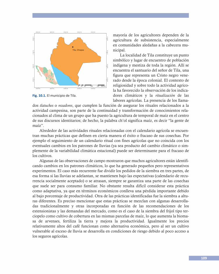
109
dos tlatuches o rezadores, que cumplen la función de asegurar los rituales relacionados a la actividad campesina, son parte de la continuidad y transformación de conocimientos rela-cionados al clima de un grupo que ha puesto la agricultura de temporal de maíz en el centro de sus discursos identitarios; de hecho, la palabra ch’ol significa maíz, es decir “la gente de maíz”.
Alrededor de las actividades rituales relacionadas con el calendario agrícola se encuen-tran muchas prácticas que definen en cierta manera el éxito o fracaso de sus cosechas. Por ejemplo el seguimiento de un calendario ritual con fines agrícolas que no coincida con los eventuales cambios en los patrones de lluvias (ya sea producto del cambio climático o sim-plemente de la variabilidad climática estacional) puede ser determinante para el fracaso de los cultivos.
Algunas de las observaciones de campo mostraron que muchos agricultores están identifi-cando cambios en los patrones climáticos, lo que ha generado pequeños pero representativos experimentos. El caso más recurrente fue dividir los pedidos de la siembra en tres partes, de esa forma si las lluvias se adelantan, se mantienen bajo las expectativas (calendario de recu-rrencia socialmente aceptado) o se atrasan, siempre se garantiza una parte de las cosechas que suele ser para consumo familiar. No obstante resulta difícil considerar esta práctica como adaptativa, ya que en términos económicos conlleva una pérdida importante debido al bajo porcentaje de productividad. Otra de las prácticas identificadas fue la siembra a altu-ras diferentes. Es preciso mencionar que estas prácticas se mezclan con algunas desarrolla-das tradicionalmente y otras incorporadas en función de las recomendaciones de los extensionistas y las demandas del mercado, como es el caso de la siembra del frijol tipo ter-ciopelo como cultivo de cobertura en las mismas parcelas de maíz, lo que aumenta la bioma-sa de arvenses, fertiliza la tierra y mejora la productividad. Igualmente los precios relativamente altos del café funcionan como alternativa económica, pero al ser un cultivo vulnerable al exceso de lluvia se desarrolla en condiciones de riesgo debido al poco acceso a los seguros agrícolas.
Fig. 10.1. El municipio de Tila.
Tila, Chiapas
0 25 50 100 150
91º0’0’’W92º0’0’’W93º0’0’’W94º0’0’’W95º0’0’’W
91º0’0’’W
15º0
’0’’N
16º0
’0’’N
17º0
’0’’N
18º0
’0’’N
92º0’0’’W93º0’0’’W94º0’0’’W95º0’0’’W
200 km
15º0
’0’’N
16º0
’0’’N
17º0
’0’’N
18º0
’0’’N
mayoría de los agricultores dependen de la agricultura de subsistencia, especialmente en comunidades aledañas a la cabecera mu-nicipal.
La localidad de Tila constituye un punto simbólico y lugar de encuentro de población indígena y mestiza de toda la región. Allí se encuentra el santuario del señor de Tila, una figura que representa un Cristo negro vene-rado desde la época colonial. El contexto de religiosidad y sobre todo la actividad agríco-la ha favorecido la observación de los indica-dores climáticos y la ritualización de las labores agrícolas. La presencia de los llama-
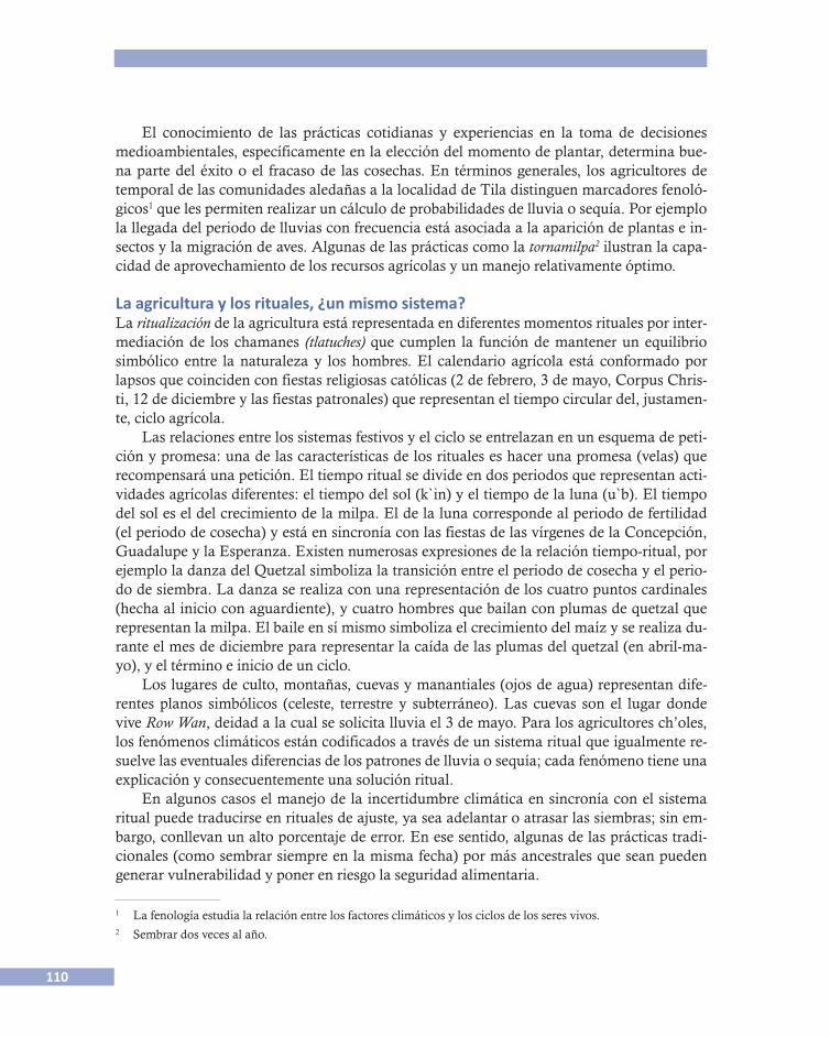
110
El conocimiento de las prácticas cotidianas y experiencias en la toma de decisiones medioambientales, específicamente en la elección del momento de plantar, determina bue-na parte del éxito o el fracaso de las cosechas. En términos generales, los agricultores de temporal de las comunidades aledañas a la localidad de Tila distinguen marcadores fenoló-gicos1 que les permiten realizar un cálculo de probabilidades de lluvia o sequía. Por ejemplo la llegada del periodo de lluvias con frecuencia está asociada a la aparición de plantas e in-sectos y la migración de aves. Algunas de las prácticas como la tornamilpa2 ilustran la capa-cidad de aprovechamiento de los recursos agrícolas y un manejo relativamente óptimo.
La agricultura y los rituales, ¿un mismo sistema?La ritualización de la agricultura está representada en diferentes momentos rituales por inter-mediación de los chamanes (tlatuches) que cumplen la función de mantener un equilibrio simbólico entre la naturaleza y los hombres. El calendario agrícola está conformado por lapsos que coinciden con fiestas religiosas católicas (2 de febrero, 3 de mayo, Corpus Chris-ti, 12 de diciembre y las fiestas patronales) que representan el tiempo circular del, justamen-te, ciclo agrícola.
Las relaciones entre los sistemas festivos y el ciclo se entrelazan en un esquema de peti-ción y promesa: una de las características de los rituales es hacer una promesa (velas) que recompensará una petición. El tiempo ritual se divide en dos periodos que representan acti-vidades agrícolas diferentes: el tiempo del sol (k`in) y el tiempo de la luna (u`b). El tiempo del sol es el del crecimiento de la milpa. El de la luna corresponde al periodo de fertilidad (el periodo de cosecha) y está en sincronía con las fiestas de las vírgenes de la Concepción, Guadalupe y la Esperanza. Existen numerosas expresiones de la relación tiempo-ritual, por ejemplo la danza del Quetzal simboliza la transición entre el periodo de cosecha y el perio-do de siembra. La danza se realiza con una representación de los cuatro puntos cardinales (hecha al inicio con aguardiente), y cuatro hombres que bailan con plumas de quetzal que representan la milpa. El baile en sí mismo simboliza el crecimiento del maíz y se realiza du-rante el mes de diciembre para representar la caída de las plumas del quetzal (en abril-ma-yo), y el término e inicio de un ciclo.
Los lugares de culto, montañas, cuevas y manantiales (ojos de agua) representan dife-rentes planos simbólicos (celeste, terrestre y subterráneo). Las cuevas son el lugar donde vive Row Wan, deidad a la cual se solicita lluvia el 3 de mayo. Para los agricultores ch’oles, los fenómenos climáticos están codificados a través de un sistema ritual que igualmente re-suelve las eventuales diferencias de los patrones de lluvia o sequía; cada fenómeno tiene una explicación y consecuentemente una solución ritual.
En algunos casos el manejo de la incertidumbre climática en sincronía con el sistema ritual puede traducirse en rituales de ajuste, ya sea adelantar o atrasar las siembras; sin em-bargo, conllevan un alto porcentaje de error. En ese sentido, algunas de las prácticas tradi-cionales (como sembrar siempre en la misma fecha) por más ancestrales que sean pueden generar vulnerabilidad y poner en riesgo la seguridad alimentaria.
1 La fenología estudia la relación entre los factores climáticos y los ciclos de los seres vivos.2 Sembrar dos veces al año.
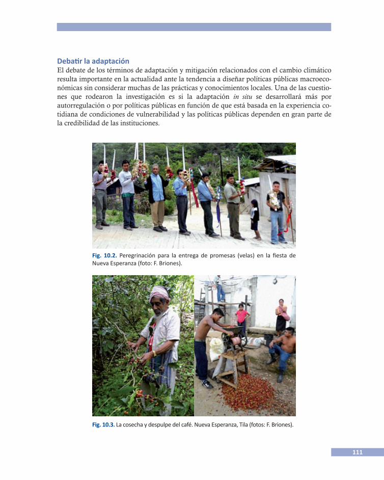
111
Debatir la adaptación El debate de los términos de adaptación y mitigación relacionados con el cambio climático resulta importante en la actualidad ante la tendencia a diseñar políticas públicas macroeco-nómicas sin considerar muchas de las prácticas y conocimientos locales. Una de las cuestio-nes que rodearon la investigación es si la adaptación in situ se desarrollará más por autorregulación o por políticas públicas en función de que está basada en la experiencia co-tidiana de condiciones de vulnerabilidad y las políticas públicas dependen en gran parte de la credibilidad de las instituciones.
Fig. 10.3. La cosecha y despulpe del café. Nueva Esperanza, Tila (fotos: F. Briones).
Fig. 10.2. Peregrinación para la entrega de promesas (velas) en la fiesta de Nueva Esperanza (foto: F. Briones).
112
En los próximos años vamos a escuchar cada vez más hablar de medidas de adaptación, lo que implicará cambios en las políticas agrícolas. Uno de los riesgos es convertir la adapta-ción en un paradigma comparable con lo que fue el desarrollo de la posguerra. ¿Y si en 30 o 40 años descubrimos que las medidas de adaptación no funcionan? Quizá uno de los princi-pios para el diseño de adaptaciones exitosas consiste en reconocer que las sociedades, pese a muchas limitantes estructurales, no son pasivas frente a sus entornos, lo cual no quiere decir que todas sus prácticas y saberes tradicionales sean siempre convenientes, pero pone en el centro del debate la adaptación proactiva de las comunidades frente a la lentitud de las polí-ticas públicas limitadas hasta el momento en protocolos internacionales que tomarán varios años en tener impactos en la escala local.
Referencias
Panel Intergubernamental de Cambio Climático (ipcc) 2007 Climate Change 2007: The Physical Science Basis. Summary for Policymakers. Contribu-
tion of Working Group I to the Fourth Assessment Report of the Intergovernmental Panel on Climate Change. Panel Intergubernamental de Cambio Climático, Ginebra, Suiza.
Rubio, Gutierrez Horacio y Triana Ramírez Cesar 2006 Gestión Integrada de Crecientes. Caso de Estudio. México: río Grijalva. Organización Meteo-
rológica Mundial, Global Water Parthnership.
Contacto Fernando Briones Gamboa, ciesas, México: <[email protected]>.
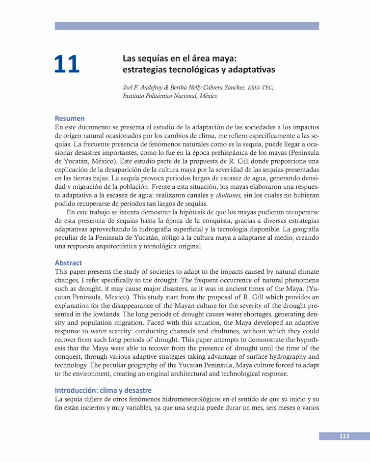
113
11 Las sequías en el área maya: estrategias tecnológicas y adaptativas
Joel F. Audefroy & Bertha Nelly Cabrera Sánchez, esia-tec, Instituto Politécnico Nacional, México
ResumenEn este documento se presenta el estudio de la adaptación de las sociedades a los impactos de origen natural ocasionados por los cambios de clima, me refiero específicamente a las se-quías. La frecuente presencia de fenómenos naturales como es la sequía, puede llegar a oca-sionar desastres importantes, como lo fue en la época prehispánica de los mayas (Península de Yucatán, México). Este estudio parte de la propuesta de R. Gill donde proporciona una explicación de la desaparición de la cultura maya por la severidad de las sequías presentadas en las tierras bajas. La sequía provoca periodos largos de escasez de agua, generando densi-dad y migración de la población. Frente a esta situación, los mayas elaboraron una respues-ta adaptativa a la escasez de agua: realizaron canales y chultunes, sin los cuales no hubieran podido recuperarse de periodos tan largos de sequías.
En este trabajo se intenta demostrar la hipótesis de que los mayas pudieron recuperarse de esta presencia de sequías hasta la época de la conquista, gracias a diversas estrategias adaptativas aprovechando la hidrografía superficial y la tecnología disponible. La geografía peculiar de la Península de Yucatán, obligó a la cultura maya a adaptarse al medio, creando una respuesta arquitectónica y tecnológica original.
AbstractThis paper presents the study of societies to adapt to the impacts caused by natural climate changes, I refer specifically to the drought. The frequent occurrence of natural phenomena such as drought, it may cause major disasters, as it was in ancient times of the Maya. (Yu-catan Peninsula, Mexico). This study start from the proposal of R. Gill which provides an explanation for the disappearance of the Mayan culture for the severity of the drought pre-sented in the lowlands. The long periods of drought causes water shortages, generating den-sity and population migration. Faced with this situation, the Maya developed an adaptive response to water scarcity: conducting channels and chultunes, without which they could recover from such long periods of drought. This paper attempts to demonstrate the hypoth-esis that the Maya were able to recover from the presence of drought until the time of the conquest, through various adaptive strategies taking advantage of surface hydrography and technology. The peculiar geography of the Yucatan Peninsula, Maya culture forced to adapt to the environment, creating an original architectural and technological response.
Introducción: clima y desastreLa sequía difiere de otros fenómenos hidrometeorológicos en el sentido de que su inicio y su fin están inciertos y muy variables, ya que una sequía puede durar un mes, seis meses o varios
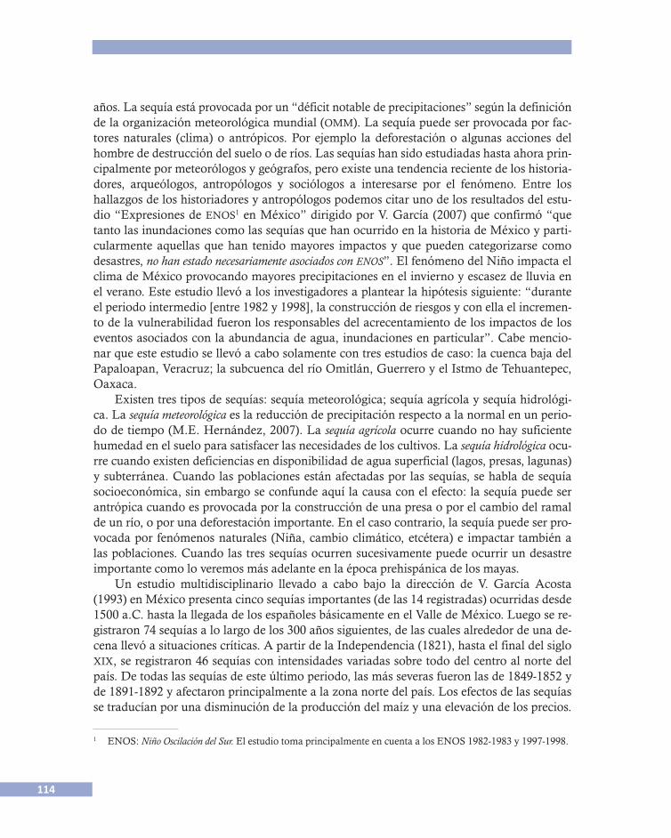
114
años. La sequía está provocada por un “déficit notable de precipitaciones” según la definición de la organización meteorológica mundial (omm). La sequía puede ser provocada por fac-tores naturales (clima) o antrópicos. Por ejemplo la deforestación o algunas acciones del hombre de destrucción del suelo o de ríos. Las sequías han sido estudiadas hasta ahora prin-cipalmente por meteorólogos y geógrafos, pero existe una tendencia reciente de los historia-dores, arqueólogos, antropólogos y sociólogos a interesarse por el fenómeno. Entre los hallazgos de los historiadores y antropólogos podemos citar uno de los resultados del estu-dio “Expresiones de enos1 en México” dirigido por V. García (2007) que confirmó “que tanto las inundaciones como las sequías que han ocurrido en la historia de México y parti-cularmente aquellas que han tenido mayores impactos y que pueden categorizarse como desastres, no han estado necesariamente asociados con enos”. El fenómeno del Niño impacta el clima de México provocando mayores precipitaciones en el invierno y escasez de lluvia en el verano. Este estudio llevó a los investigadores a plantear la hipótesis siguiente: “durante el periodo intermedio [entre 1982 y 1998], la construcción de riesgos y con ella el incremen-to de la vulnerabilidad fueron los responsables del acrecentamiento de los impactos de los eventos asociados con la abundancia de agua, inundaciones en particular”. Cabe mencio-nar que este estudio se llevó a cabo solamente con tres estudios de caso: la cuenca baja del Papaloapan, Veracruz; la subcuenca del río Omitlán, Guerrero y el Istmo de Tehuantepec, Oaxaca.
Existen tres tipos de sequías: sequía meteorológica; sequía agrícola y sequía hidrológi-ca. La sequía meteorológica es la reducción de precipitación respecto a la normal en un perio-do de tiempo (M.E. Hernández, 2007). La sequía agrícola ocurre cuando no hay suficiente humedad en el suelo para satisfacer las necesidades de los cultivos. La sequía hidrológica ocu-rre cuando existen deficiencias en disponibilidad de agua superficial (lagos, presas, lagunas) y subterránea. Cuando las poblaciones están afectadas por las sequías, se habla de sequía socioeconómica, sin embargo se confunde aquí la causa con el efecto: la sequía puede ser antrópica cuando es provocada por la construcción de una presa o por el cambio del ramal de un río, o por una deforestación importante. En el caso contrario, la sequía puede ser pro-vocada por fenómenos naturales (Niña, cambio climático, etcétera) e impactar también a las poblaciones. Cuando las tres sequías ocurren sucesivamente puede ocurrir un desastre importante como lo veremos más adelante en la época prehispánica de los mayas.
Un estudio multidisciplinario llevado a cabo bajo la dirección de V. García Acosta (1993) en México presenta cinco sequías importantes (de las 14 registradas) ocurridas desde 1500 a.C. hasta la llegada de los españoles básicamente en el Valle de México. Luego se re-gistraron 74 sequías a lo largo de los 300 años siguientes, de las cuales alrededor de una de-cena llevó a situaciones críticas. A partir de la Independencia (1821), hasta el final del siglo xix, se registraron 46 sequías con intensidades variadas sobre todo del centro al norte del país. De todas las sequías de este último periodo, las más severas fueron las de 1849-1852 y de 1891-1892 y afectaron principalmente a la zona norte del país. Los efectos de las sequías se traducían por una disminución de la producción del maíz y una elevación de los precios.
1 ENOS: Niño Oscilación del Sur. El estudio toma principalmente en cuenta a los ENOS 1982-1983 y 1997-1998.
115
Frente a tal situación, plantearemos como hipótesis de trabajo que una de las estrate-gias de subsistencia de los indígenas fue la de poder almacenar las cosechas, es decir construir trojes de granos, llamados cuesco-mates en el estado de Morelos (véase la figu-ra 11.1). Durante la época colonial, las autoridades tenían la costumbre de almace-nar granos (alhóndigas)2 en las ciudades que funcionaban desde el siglo xvi en Nueva Es-paña y tenían el propósito de regular los pre-cios y combatir el acaparamiento de grano. En la ciudad de México estaba en la calle de la Alhóndiga.
La sequía es uno de los factores más significativos que contribuyen a la degradación del suelo, pero las actividades humanas son las principales causas de este proceso. La sequía y la desertificación que implica disminuyen la resistencia de las tierras ante la variabilidad cli-mática natural. El suelo se vuelve menos productivo, la vegetación se deteriora y la desertifi-cación puede implicar enormes costos sociales. Una sequía prolongada conlleva un proceso de desertificación y puede provocar migraciones de poblaciones. Se estima que en México el deterioro del suelo avanza de 100 000 a 200 000 ha/año lo que implica que la superficie agrí-cola disminuya a causa de los procesos de degradación (M.E. Hernández, 2007).
En México las principales estrategias para enfrentar las sequías se agrupan en tres tipos según Florescano y Swan (1995): el primer grupo son los actos mágicos llevada a cabo por los “hacedores de lluvia”, llamados los graniceros en el centro del país que ruegan a dioses y santos. En las culturas mesoamericanas agrarias era extremadamente importante poder controlar los fenómenos meteorológicos particularmente variados según las altitudes (Jo-hanna Broda, 1997). El segundo grupo son acciones técnicas o tecnológicas como la cons-trucción de pozos, sistemas de riesgo, recolección de aguas de lluvia, construcción de almacén de granos. El tercer grupo está relacionado con las políticas para disminuir los efec-tos de la sequía, como el control de precios y el control del almacenamiento de granos. En este trabajo nos interesamos solamente por el segundo grupo: las acciones técnicas y adap-tativas a sequías en la región maya del sur del país.
Las respuestas tecnológicas mayasUnas de las principales respuestas tecnológicas mayas a las sequías fueron los canales, dre-nando el exceso de agua de las tierras inundadas, conservando la humedad del suelo y reco-lectando y conservando el agua de lluvia. El almacenaje en estanques conocidos como chultunes y los sistemas de derivación de canales dependían de drenajes permanentes y de
2 Alhóndiga viene de la palabra alfóndiga, derivada del árabe alfondec que significa casa pública destinada a la
compra-venta de granos.
116
captaciones de escorrentías estacionales. Esta comproba-do3 que los dos componentes principales de la explotación del agua, la canalización o la construcción de acequias y la construcción de estanques surgieron antes de la arquitectu-ra monumental. Brainerd (1956) propuso que para el pe-riodo Clásico Temprano (250-600 d.C.) ya se encontraban funcionando los chultunes y cuando menos para el perio-do Preclásico Tardío (300 a.C.-250 d.C.) ya habían comen-zado a construirse, es decir que en la época de las mayores sequías, 800 d.C-1000 d.C. existían los chultunes.4
El termino chultún significa cisterna labrada en la roca para contener agua de lluvia, proviene según el dicciona-rio Maya Cordemex5 de la contracción de chulub (agua de lluvia) y tun (piedra labrada).
Según los cálculos de Brainerd (1976), en base a los dibujos de Thompson (1897), el chultún promedio de La-bná podía contener 28 125 litros de agua y pudo haber ser-vido para un máximo de 25 familias o 125 personas durante un periodo de 190 días, un poco más de 6 meses, lapso que dura normalmente una estación de sequía. Así, los chultunes de estas dimensio-nes podrían tener la capacidad suficiente para almacenar el agua necesaria para una familia en sus usos domésticos (véase la figura 11.2).
En el área maya del norte, los chultunes se encuentran en una región donde el nivel freático está demasiado profundo e impide la perforación de pozos. Parece, según Gill (2008) que el límite de perforación de los pozos era de 23 m. Esto explica porqué en las tie-rras bajas mayas se prefería la recolección de agua sobre la desviación y la fuente sobre la distribución. La construcción de chultunes permitió la presencia de poblaciones donde no había agua al alcance. El punto tecnológico crítico de los mayas era de 23 m. En la zona de Chichén Itzá que posee una topografía kárstica, el nivel freático es de 22 a 24 metros. Pero en el distrito de Bolonchén, donde hay una carencia de corrientes superficiales de agua, el nivel freático alcanza una profundidad de 80 a 90 metros, lo que quedaba fuera del alcance de los mayas prehispánicos.
La tecnología hidráulica del Preclásico Tardío maya aprovechó las depresiones de baja localización levemente inclinadas para captar y desviar agua a canales o estanques de agua construidos. Hacia fines del Preclásico Tardío, Edzná y El Mirador indican excavaciones de sistemas de canales y estanques y la construcción de terraplenes utilizados para contener o desviar agua a través de zonas más bajas. En el Clásico Tardío, la tecnología hidráulica per-mitió que los mayas construyeran ciudades en terrenos altos, utilizando la propia ciudad
3 Matheny, 1982; Scaboroug, 1993, citado por Gill.4 Brainerd citado por Zapata Peraza, 1989.5 Barrera V., 1980, citado por Zapata Peraza, 1989.
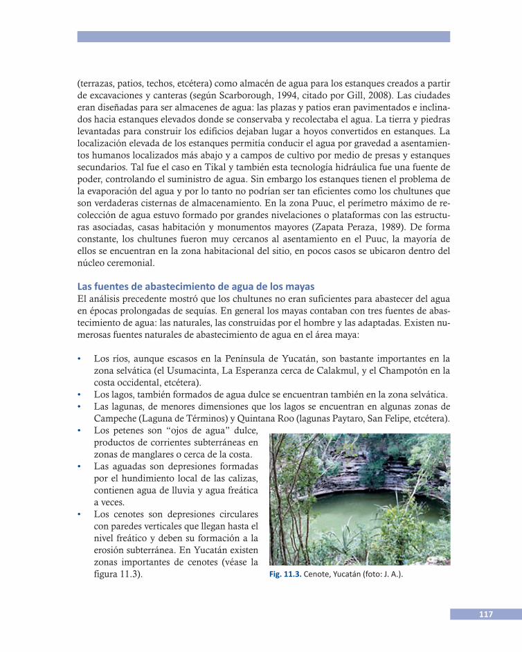
117
(terrazas, patios, techos, etcétera) como almacén de agua para los estanques creados a partir de excavaciones y canteras (según Scarborough, 1994, citado por Gill, 2008). Las ciudades eran diseñadas para ser almacenes de agua: las plazas y patios eran pavimentados e inclina-dos hacia estanques elevados donde se conservaba y recolectaba el agua. La tierra y piedras levantadas para construir los edificios dejaban lugar a hoyos convertidos en estanques. La localización elevada de los estanques permitía conducir el agua por gravedad a asentamien-tos humanos localizados más abajo y a campos de cultivo por medio de presas y estanques secundarios. Tal fue el caso en Tikal y también esta tecnología hidráulica fue una fuente de poder, controlando el suministro de agua. Sin embargo los estanques tienen el problema de la evaporación del agua y por lo tanto no podrían ser tan eficientes como los chultunes que son verdaderas cisternas de almacenamiento. En la zona Puuc, el perímetro máximo de re-colección de agua estuvo formado por grandes nivelaciones o plataformas con las estructu-ras asociadas, casas habitación y monumentos mayores (Zapata Peraza, 1989). De forma constante, los chultunes fueron muy cercanos al asentamiento en el Puuc, la mayoría de ellos se encuentran en la zona habitacional del sitio, en pocos casos se ubicaron dentro del núcleo ceremonial.
Las fuentes de abastecimiento de agua de los mayasEl análisis precedente mostró que los chultunes no eran suficientes para abastecer del agua en épocas prolongadas de sequías. En general los mayas contaban con tres fuentes de abas-tecimiento de agua: las naturales, las construidas por el hombre y las adaptadas. Existen nu-merosas fuentes naturales de abastecimiento de agua en el área maya:
• Los ríos, aunque escasos en la Península de Yucatán, son bastante importantes en la zona selvática (el Usumacinta, La Esperanza cerca de Calakmul, y el Champotón en la costa occidental, etcétera).
• Los lagos, también formados de agua dulce se encuentran también en la zona selvática.• Las lagunas, de menores dimensiones que los lagos se encuentran en algunas zonas de
Campeche (Laguna de Términos) y Quintana Roo (lagunas Paytaro, San Felipe, etcétera).
Fig. 11.3. Cenote, Yucatán (foto: J. A.).
• Los petenes son “ojos de agua” dulce, productos de corrientes subterráneas en zonas de manglares o cerca de la costa.
• Las aguadas son depresiones formadas por el hundimiento local de las calizas, contienen agua de lluvia y agua freática a veces.
• Los cenotes son depresiones circulares con paredes verticales que llegan hasta el nivel freático y deben su formación a la erosión subterránea. En Yucatán existen zonas importantes de cenotes (véase la figura 11.3).
118
• Las rejolladas son derrumbes que no llegaron a ser cenotes y llegan a veces hasta el nivel freático y pueden conservar agua permanentemente.
• Las sartenejas son oquedades poco profundas, de menos de dos metros, de un aflora-miento de la roca madre y se llenan con agua de lluvia.
• Los akalchés son llanos o bajíos extensos en donde se deposita el agua de lluvia y se conserva durante algunos meses.
• Las xuayabás son pequeñas depresiones que se encuentran al pie de un árbol con poca profundidad (entre 50 y 60 cm) y conservan el agua de lluvia algún tiempo.
• Los actún (o haltún) son pequeños desfondamientos naturales de la roca de gran pro-fundidad con un acceso desde la superficie y permiten que se acumule el agua de lluvia.
Las fuentes de abastecimiento de agua construidas por el hombre son las siguientes:
• Los chultunes.• Los pozos son perforaciones profundas en el suelo hasta llegar al nivel del manto freáti-
co. Sin embargo los mayas técnicamente tenían un límite de 20-30 metros de profundi-dad como se mencionó anteriormente. Las paredes eran revestidas de piedra.
• La represa es un estancamiento o detención artificial de una corriente de agua. Los ma-yas utilizaban este procedimiento para canalizar las corrientes de temporales.
• Los canales son obras hidráulicas cuya función consiste en desplazar el agua de un lu-gar a otro. Algunos canales permiten el drenaje de terrenos inundados en época de llu-via para almacenarla.
• Las únicas fuentes de abastecimiento naturales que fueron adaptadas por los mayas fue-ron las aguadas. La adaptación consistía en recubrimientos de estuco, construcción de bordes y accesos así como el mantenimiento de estos trabajos.
La hidrografía superficial es muy escasa en la península y prácticamente se carece de fuentes superficiales de agua. La precipitación es muy escasa, menos de medio metro al año. Es esta geografía peculiar la que obligó a los mayas a adaptarse al medio, creando chultu-nes, pozos y canales.
Descripción del chultúnSegún Zapata Peraza (1989) un chultún se compone de a) zona de captación; b) boca; c) cue-llo; y d) cámara (véase la figura 11.4). La zona de captación es un área pavimentada de cin-co metros de diámetro alrededor de la boca de la cisterna, con un ligero pendiente de manera que la lluvia cae en el depósito. La boca es la parte circular, generalmente un anillo circular monolítico por donde penetra el agua. Esta parte está cubierta por una tapa de pie-dra o madera. El cuello está dividido en dos partes: la parte superior formada de hilada de piedras labradas unidas con estuco y la inferior de roca madre. Toda la superficie del cuello está recubierta de estuco. La cámara es la sección que forma el cuerpo del depósito y sus paredes van siempre recubiertas de estuco. Los constructores mayas observaron que la roca caliza arenosa se encontraba debajo de la dura capa superficial, y por lo tanto formaron la mayor parte de las cavidades de los chultunes en este material tan fácil de trabajar.

119
El caso ya citado de Labná, Clásico Tardío (municipio de Oxkutzcab, Yucatán), es in-teresante porque es precisamente un sitio donde el nivel freático es muy profundo, alcan-zando entre 70 y 80 metros y por lo tanto era imposible técnicamente para los mayas excavar un pozo de esta profundidad. En este sitio se encontró en el conjunto del Palacio, un chultún asociado construido en la misma plataforma (véase la figura 11.5). Este conjun-to está formado por dos niveles cada uno con varias cámaras abovedadas. El chultún fue construido con el sistema de la bóveda maya (2.51m de altura) y no fue excavado como la mayoría de los chultunes.
Fig. 11.4. Corte descriptivo de un chultún (fuente: Zapata Peraza, 1985).
Fig. 11.5. Labná, corte longitudinal del Palacio (fuente: Zapata Peraza, 1985).
Anillo
Canal
Tierra
Piedra labrada
Roca madre
Sascab

120
Los usos y eficacia de los chultunesPara poder medir correctamente la eficacia de los chultunes se necesita conocer sus caracte-rísticas en cuanto al tamaño y la capacidad de almacenamiento y las precipitaciones. Sin embargo sabemos, según Gill, que las precipitaciones han variado a través del tiempo en la Península de Yucatán hasta llegar a largos periodos de sequías. Zapata Peraza (1989) tomó como ejemplo del chultún de Uxmal (Yucatán) de una capacidad de 9 300 litros y trata de calcular la cantidad de agua disponible a través de la estación seca a lo largo de 151 días en-tre el primero de diciembre y el 31 de abril. La precipitación anual en el área de Uxmal fluc-tua entre 900 y 1 250 mm, lo que no es suficiente para llenar el chultún ya que en esta área de captación (7 m2) sería entre 6 300 y 8 750 litros. El autor concluye que a partir de estas cifras, los mayas canalizaban la lluvia de los techos y áreas pavimentadas al depósito para poder llenarlo. Considerando un área de captación de 400 m2, los cálculos para un año con preci-pitaciones promedio dan la disponibilidad de 251 litros por día en el periodo de diciembre a abril. Considerando una año de sequía (el año de 1969-1970), la disponibilidad da una pro-medio de sólo 105 litros por día en este mismo periodo. Si se consideran tres o cuatro años seguidos de sequía la cantidad de agua disponible es aún menor. Este análisis cuantitativo nos lleva a las conclusiones siguientes: el área de captación es más que la sola plataforma del chultún e incluye una captación de los techos y patios (véase la figura 11.6). En épocas de sequías prolongadas, los mayas tenían que acarrear agua de sitios lejanos por medio de jarras desde un “ojo de agua”, pozos o represas. Es decir que tenían que utilizar otras opcio-nes de acumulación de agua como la adaptación de las aguadas que requerían de una gran organización social y la participación de muchas personas, tanto para su elaboración como por su mantenimiento (Zapata Peraza, 1985).
Fig. 11.6. Área de captación del agua (fuente: Zapata Peraza, 1985).
Sascab
Roca madre
Cámara
121
Discusiones y conclusionesEs interesante observar que en zonas como la de Chichén Itzá, donde el manto freático no es tan profundo (22 a 24 metros), los mayas construyeron chultunes a pesar de que se podía encontrar fácilmente el manto freático. De esta observación se puede deducir que hubo pe-riodos de sequías en donde el manto freático había bajado tanto que ya no era posible alcan-zarlo. En su proceso de adaptación, los mayas construyeron los chultunes para almacenar el agua de lluvia que podían conservar hasta que se necesitara.
Parece, según las conclusiones del estudio de Zapata Peraza (1989), que los chultunes del área maya del norte sirvieron exclusivamente para la captación y el almacenamiento de agua pluvial. Sin embargo, los “chultunes” de la región del sur y del Petén guatemalteco, dadas sus características morfológicas y sus relaciones con las fuentes superficiales de agua, son posiblemente almacenes para resguardar los granos alimenticios necesarios para la sub-sistencia. De esto se podría tal vez deducir que la región del sur tuvo sequías agrícolas, mien-tras que la región del norte tuvo sequías hidrológicas.
Esta primera aproximación sobre las sequías en la zona maya de la península deja algu-nas pistas para investigaciones futuras: por ejemplo ¿cuáles son las estrategias actuales de las familias mayas rurales para enfrentar situaciones de sequías tomando en cuenta que las con-diciones de abastecimiento de agua han cambiado? Los cambios climáticos anunciados por el calentamiento global tendrán consecuencias inevitables en la región. Sin embargo, ¿cómo la población ahora acostumbrada a la heteronomía (suministro de agua potable), va poder adaptarse a nuevas sequías?
Referencias
Albores, Beatriz y Johanna Broda (coords.) 1993 Graniceros, cosmovisión y meteorología indígenas de Mesoamérica, México, El Colegio Mexi-
quense-unam, pp. 563.Florescano, Enrique y Susan Swan 1995 Breve historia de la sequía en México, Xalapa, Universidad Veracruzana.Garcia Acosta, Virginia 1993 “Las sequías históricas de México”, en Desastres y Sociedad, Revista semestral de la Red
de estudios sociales en prevención de desastres en América Latina, Julio-Diciembre, núm 1, Año 1, Bogotá.
Hernández Cerda, María Engracia et al. 2007 Mitos y realidades en la sequía en México, México, unam.Wilches-Chaux, Gustavo 2007 ¿Qu-enos pasa? guía de la red para la gestión radical de riesgos asociados con el fe-
nómeno enos, Bogotá, La Red-oxfam.Zapata Peraza, Renée Lorelei 1985 “Los chultunes de la región serrana de Yucatán”, Cuadernos de arquitectura, núm. 5,
septiembre, México, unam.
122
Zapata Peraza, Renée Lorelei 1989 Los chultunes, sistemas de captación y almacenamiento de agua pluvial, México, inah.
Contacto Joel F. Audefroy, Instituto Politécnico Nacional, México: <[email protected]>. Bertha Nelly Cabrera Sánchez, Instituto Politécnico Nacional, México: <[email protected]>.

123
12 Cuando el agua corre... Estrategias y prácticas espaciales para convivir con fenómenos
hidrometeorológicos. El caso de la ciudad de Campeche, México
Jimena Cuevas Portilla, ciesas/unam, México
ResumenLos ciclones tropicales, las lluvias y los nortes son fenómenos hidrometeorológicos que, como lo demuestran los registros históricos y las evidencias contemporáneas, afectan a la ciudad de Campeche. En este trabajo se presenta un análisis de la manera en la que sus habi-tantes han aprendido a convivir con ellos y sus consecuencias. A lo largo de la presentación se mostrarán los elementos fundamentales por medio de los cuales sucede este proceso de convivencia. En primer lugar, se describirán de manera sucinta las condiciones geográficas y climáticas de la ciudad en cuestión para mostrar su susceptibilidad a los fenómenos hidro-meteorológicos. Posteriormente, basados en documentos históricos y testimonios orales, se analizará cómo han adecuado el espacio geográfico de la ciudad para no padecer los efectos de dichos fenómenos. Por último, se concluirá que en virtud de la recurrente presencia de ciclones, lluvias, nortes e inundaciones, en la ciudad de Campeche se han diseñado estrate-gias y prácticas espaciales para hacer frente a estos fenómenos hidrometeorológicos.
AbstractThe tropical storms, rains, “nortes” are hydrometeorological phenomena that, as they de-monstrate to the historical registries and the contemporary evidences, affect the city of Campeche. In this text an analysis of the way will appear in which their inhabitants have learned to coexist with them and their consequences. Throughout the presentation will ap-pear the fundamental elements by means of which east process of coexistence happens. First of all, the geographic and climatic conditions of the city at issue will be described of brief way to show their susceptibility the hydrometeorological phenomena. Later, based on historical documents and oral testimonies, it will be analyzed how they have adapted the geographic space of the city not to suffer the effects of these phenomena. Finally, one will conclude that by virtue of the recurrence presence of cyclones, rains, north and floods, in the city of Campeche space strategies and practices have been designed to do against these hydrometeorological phenomena.

124
Cuando el agua corre...Caminando por impredecibles rutas y soplando de este a oeste desde fines de la primavera hasta el otoño, los vientos sin rumbo ni morada se maduran en el Atlántico central, apenas rumiando en escarchas lo que será después enorme fu�ria desatada. Y a medida que avanzan, convirtiéndose en huracanes de variada intensidad, se abaten sobre el mar Caribe […]. Pero en el Golfo de México, que es hacia donde los conduce su carrera, las aguas cálidas son más superficiales, lo que facilita su transformación en húmedos torbellinos y tormentas eléctricas.1
Así describe a los huracanes que recorren esta región del mundo el historiador veracruzano Antonio García de León al inicio de su libro El mar de los deseos. El Caribe hispano musical. Historia y contrapunto, y con ello, yo los introduzco a esta región en la que los huracanes ade-más de percibirse como húmedos torbellinos, son parte del vivir cotidiano.
Es en este acontecer cotidiano durante la temporada de lluvias y huracanes cuando los in-dividuos son capaces de desarrollar la prevención, la resiliencia, la reducción de vulnerabili-dad, todas ellas, capacidades que apuntan a un mismo objetivo: vivir de manera adecuada en un espacio propenso a amenazas naturales o construidas. En este trabajo se presenta el caso de la ciudad de Campeche, que a mi juicio, es una muestra de esta constante adecua-ción del espacio. Lo que quiero resaltar es esta capacidad creativa que los campechanos han tenido que desarrollar a partir de acontecimientos extraordinarios.
El estado de Campeche se sitúa en el sureste de la República Mexicana, conforma la parte oeste de la Península de Yucatán a la que con fines académicos se le considera una re-gión en sí misma. La ciudad de Campeche, que mira hacia el Golfo de México, se asienta en la franja oeste de la Península. Para describirla, nadie mejor que sus habitantes, que presu-men, no sin razón, de ser poetas: “en Campeche todos son poetas hasta que demuestren lo contrario”, suelen decir. Asumiendo este hecho, sería craso error de mi parte describir su ciudad con mis propias palabras.
1 García de León, Antonio (2002), El mar de los deseos. El Caribe hispano musical. Historia y contrapunto, México,
Siglo xxi editores.
Fig. 12.1. La ciudad de San Francisco de Campeche.
125
Don Felipe Suárez Naal, un amigo campechano y colaborador en mi investigación, compuso una canción que a su juicio describe los elementos arquitectónicos y culturales más importantes de esta ciudad. Al ritmo de don Felipe cito:
Mi Campeche querido de recios baluartes Me haces recordar tus leyendas de bravos piratas que me hacen soñarRecorrer tus murallas, la puerta de tierra y tu malecón[…]Caminar por tus calles de casas muy bellas de arte colonial Visitar tus iglesias, parques, alameda y la novia del marContemplar tus muchachas con sus lindos trajes de gran tradición[…]Asistir a tus ferias, a las alboradas y la procesiónY besar a tu Cristo, a tu San Francisco me infunde el amor[…]Observar junto a Juárez o Don Justo Sierra tu grandioso mar[…]Disfrutar por las tardes de la suave brisa y la puesta del sol.2
Centrado en su objetivo, el habitante-poeta, profesor jubilado, señala algunos de los ele-mentos emblemáticos que conforman a la ciudad: muralla, malecón, calles, casas, Cristo Negro, mar. Mismos elementos que retomaré para demostrar la manera en la que los cam-pechanos han transformado su espacio geográfico para poder vivir cuando el agua corre.
Es preciso tener en cuenta que la ciudad de Campeche estuvo amurallada de principios del siglo xviii hasta finales del siglo xix. La muralla establecía la división entre la ciudad intramuros, espacio habitado por la población europea, y la ciudad extramuros, habitada por el resto de la población. A mi modo de ver, los lienzos de la muralla, además de marcar la diferencia social entre la población, también fungían como frontera física que impedía el libre tránsito del agua cuando llovía. Al parecer, cuando llovía en demasía la construcción defensiva inhibía la circulación del agua.
En 1893 dio inicio la demolición de la muralla campechana. Contrario a lo que podría su-ponerse, este hecho no implicó que no hubiese inundaciones. Lo que sucedió fue que su comportamiento cambió. Antes, las inundaciones que ocurrían en la ciudad intramuros tar-daban en descender porque no tenían libre salida al mar. En cambio, sin los lienzos, el agua se dirigía rápidamente al mar, por tanto, la duración temporal de las inundaciones disminu-yó considerablemente.
La construcción del malecón es la segunda obra que encontré como muestra de la transfor-mación de la ciudad. El malecón es una barrera artificial que se construye en los puertos o ciudades situadas a la orilla del mar, con el objetivo de proteger a la población de los efectos
2 Entrevista: Jimena Cuevas Portilla, en adelante (jcp)/ Felipe Suárez Naal, profesor pensionado, Ciudad de
San Francisco de Campeche/24 de noviembre de 2008.
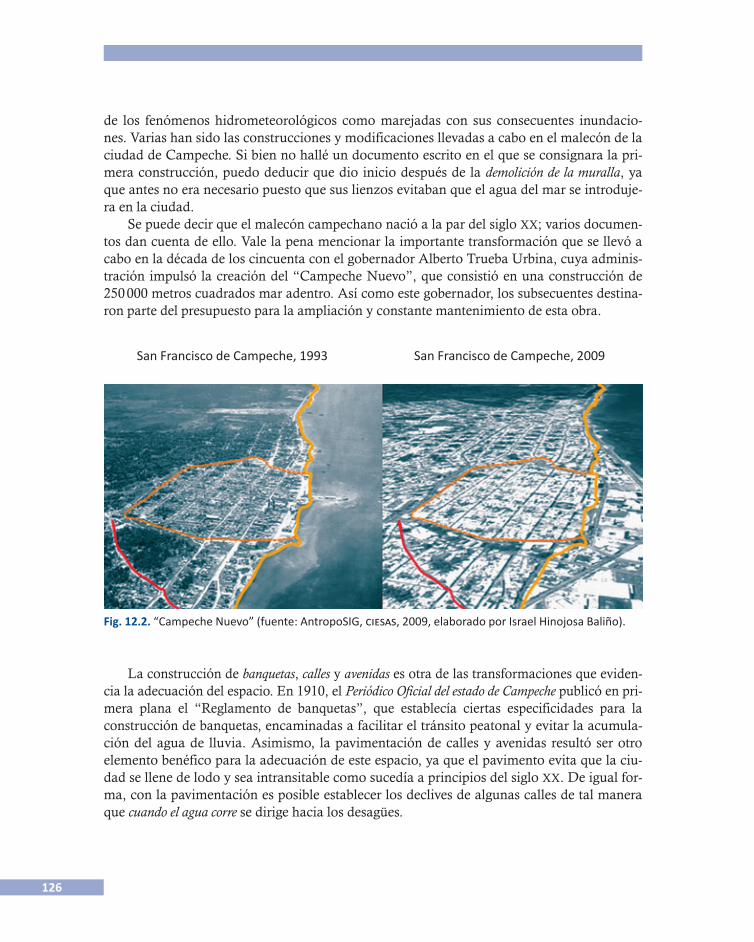
126
de los fenómenos hidrometeorológicos como marejadas con sus consecuentes inundacio-nes. Varias han sido las construcciones y modificaciones llevadas a cabo en el malecón de la ciudad de Campeche. Si bien no hallé un documento escrito en el que se consignara la pri-mera construcción, puedo deducir que dio inicio después de la demolición de la muralla, ya que antes no era necesario puesto que sus lienzos evitaban que el agua del mar se introduje-ra en la ciudad.
Se puede decir que el malecón campechano nació a la par del siglo xx; varios documen-tos dan cuenta de ello. Vale la pena mencionar la importante transformación que se llevó a cabo en la década de los cincuenta con el gobernador Alberto Trueba Urbina, cuya adminis-tración impulsó la creación del “Campeche Nuevo”, que consistió en una construcción de 250 000 metros cuadrados mar adentro. Así como este gobernador, los subsecuentes destina-ron parte del presupuesto para la ampliación y constante mantenimiento de esta obra.
La construcción de banquetas, calles y avenidas es otra de las transformaciones que eviden-cia la adecuación del espacio. En 1910, el Periódico Oficial del estado de Campeche publicó en pri-mera plana el “Reglamento de banquetas”, que establecía ciertas especificidades para la construcción de banquetas, encaminadas a facilitar el tránsito peatonal y evitar la acumula-ción del agua de lluvia. Asimismo, la pavimentación de calles y avenidas resultó ser otro elemento benéfico para la adecuación de este espacio, ya que el pavimento evita que la ciu-dad se llene de lodo y sea intransitable como sucedía a principios del siglo xx. De igual for-ma, con la pavimentación es posible establecer los declives de algunas calles de tal manera que cuando el agua corre se dirige hacia los desagües.
Fig. 12.2. “Campeche Nuevo” (fuente: AntropoSIG, ciesas, 2009, elaborado por Israel Hinojosa Baliño).
San Francisco de Campeche, 1993 San Francisco de Campeche, 2009
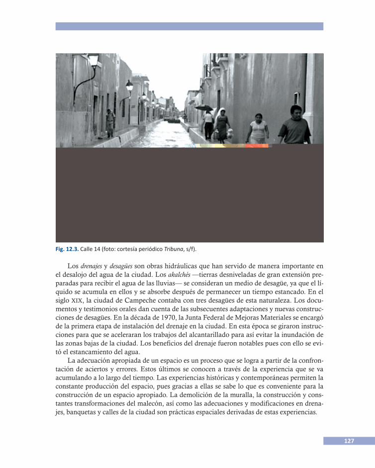
127
Los drenajes y desagües son obras hidráulicas que han servido de manera importante en el desalojo del agua de la ciudad. Los akalchés —tierras desniveladas de gran extensión pre-paradas para recibir el agua de las lluvias— se consideran un medio de desagüe, ya que el lí-quido se acumula en ellos y se absorbe después de permanecer un tiempo estancado. En el siglo xix, la ciudad de Campeche contaba con tres desagües de esta naturaleza. Los docu-mentos y testimonios orales dan cuenta de las subsecuentes adaptaciones y nuevas construc-ciones de desagües. En la década de 1970, la Junta Federal de Mejoras Materiales se encargó de la primera etapa de instalación del drenaje en la ciudad. En esta época se giraron instruc-ciones para que se aceleraran los trabajos del alcantarillado para así evitar la inundación de las zonas bajas de la ciudad. Los beneficios del drenaje fueron notables pues con ello se evi-tó el estancamiento del agua.
La adecuación apropiada de un espacio es un proceso que se logra a partir de la confron-tación de aciertos y errores. Estos últimos se conocen a través de la experiencia que se va acumulando a lo largo del tiempo. Las experiencias históricas y contemporáneas permiten la constante producción del espacio, pues gracias a ellas se sabe lo que es conveniente para la construcción de un espacio apropiado. La demolición de la muralla, la construcción y cons-tantes transformaciones del malecón, así como las adecuaciones y modificaciones en drena-jes, banquetas y calles de la ciudad son prácticas espaciales derivadas de estas experiencias.
Fig. 12.3. Calle 14 (foto: cortesía periódico Tribuna, s/f).
128
Todos los seres humanos producimos el espacio que habitamos en interacción con otros seres humanos e instituciones, a través de nuestro vivir cotidiano, de nuestras formas de ac-tuar y de entender el mundo. Estas formas son respuestas a las vivencias que vamos enfren-tando. Las primeras veces son respuestas espontáneas, ya que desconocemos lo vivido. No obstante, la repetición las vuelve parte de nuestra vida ordinaria. Al conjunto de estas for-mas las divido en estrategias y prácticas institucionales, por un lado, y por el otro, prácticas es�paciales individuales y colectivas.
Las estrategias son los instrumentos de los que se vale una institución central para decidir qué se debe hacer ante circunstancias determinadas. En este sentido, las estrategias sirven para orientar los quehaceres de la sociedad. Las estrategias no surgen espontáneamente ni sin razón. Éstas son generadas históricamente y diseñadas para resolver problemas específicos y repetiti-vos. En tanto que disposiciones institucionales, con ellas se pretende satisfacer las necesidades de la sociedad y particularmente de sus grupos hegemónicos que ven afectados sus intereses frente a fenómenos hidrometeorológicos. Obvia decir que cada estrategia supone para su reali-zación un conjunto de prácticas. Sin embargo, no es posible afirmar que hay una corresponden-cia mecánica entre una y otra. Después de todo, una cuestión es lo que se dispone para hacer y cumplir, y otra muy diferente lo que realmente se hace. Este lapsus es lo que marca la frontera y la diferencia entre la estrategia y las prácticas, sean éstas institucionales o individuales.
Las prácticas tanto institucionales como individuales son formas de actuar en función de los elementos que el espacio les ofrece. De aquí que las prácticas institucionales e individua-les se caractericen por responder a los desafíos y necesidades que el mismo espacio social plantea. No obstante, en tanto que institucionales o individuales, se diferencian las unas de las otras de manera clara. Por un lado, las prácticas institucionales que se derivan directa-mente de las estrategias son acciones que se deben llevar a cabo para poder cumplir con la es�trategia. Y las prácticas individuales se caracterizan por responder a las situaciones vividas que rebasan las cuestiones contempladas por la estrategia.
Con ánimos de resaltar las formas de actuar de los ciudadanos “de a pie”, en lo que res-ta de este caso describiré algunas de las prácticas espaciales individuales que logré identificar durante mi estancia en Campeche.
Resulta muy interesante percatarse de que los habitantes de la ciudad de Campeche han interiorizado de tal forma sus prácticas que ya no son conscientes de que las realizan. Este comportamiento se evidenció por medio de varias observaciones y de algunos cuestiona-mientos. Ante las preguntas: ¿Qué sucede en Campeche cuando un huracán toca tierra? ¿Qué sucede cuando se inunda? Las respuestas siempre fueron: “Aquí no pasa nada”. Em-pero, en las pláticas informales y formales, fue común que se refirieran relatos asociados con desastres o con efectos hidrometeorológicos importantes. Cualquier motivo daba pauta para recordar alguna situación asociada con desastres o con agua. Por ejemplo, en una ocasión, la señora Concepción Chiquini recordó por qué se mudó a su actual residencia y narró la si-guiente historia:
Nos fuimos a vivir a un pueblito que se llama Samulá, ahora ya es colonia de la ciudad de Campeche. Allá estuvimos viviendo, ¿qué será?, unos tres años y nos vimos en la necesidad
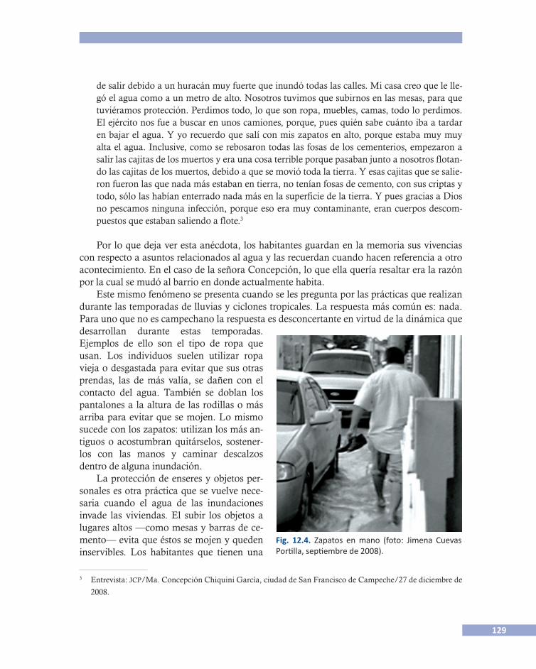
129
de salir debido a un huracán muy fuerte que inundó todas las calles. Mi casa creo que le lle-gó el agua como a un metro de alto. Nosotros tuvimos que subirnos en las mesas, para que tuviéramos protección. Perdimos todo, lo que son ropa, muebles, camas, todo lo perdimos. El ejército nos fue a buscar en unos camiones, porque, pues quién sabe cuánto iba a tardar en bajar el agua. Y yo recuerdo que salí con mis zapatos en alto, porque estaba muy muy alta el agua. Inclusive, como se rebosaron todas las fosas de los cementerios, empezaron a salir las cajitas de los muertos y era una cosa terrible porque pasaban junto a nosotros flotan-do las cajitas de los muertos, debido a que se movió toda la tierra. Y esas cajitas que se salie-ron fueron las que nada más estaban en tierra, no tenían fosas de cemento, con sus criptas y todo, sólo las habían enterrado nada más en la superficie de la tierra. Y pues gracias a Dios no pescamos ninguna infección, porque eso era muy contaminante, eran cuerpos descom-puestos que estaban saliendo a flote.3
Por lo que deja ver esta anécdota, los habitantes guardan en la memoria sus vivencias con respecto a asuntos relacionados al agua y las recuerdan cuando hacen referencia a otro acontecimiento. En el caso de la señora Concepción, lo que ella quería resaltar era la razón por la cual se mudó al barrio en donde actualmente habita.
Este mismo fenómeno se presenta cuando se les pregunta por las prácticas que realizan durante las temporadas de lluvias y ciclones tropicales. La respuesta más común es: nada. Para uno que no es campechano la respuesta es desconcertante en virtud de la dinámica que desarrollan durante estas temporadas. Ejemplos de ello son el tipo de ropa que usan. Los individuos suelen utilizar ropa vieja o desgastada para evitar que sus otras prendas, las de más valía, se dañen con el contacto del agua. También se doblan los pantalones a la altura de las rodillas o más arriba para evitar que se mojen. Lo mismo sucede con los zapatos: utilizan los más an-tiguos o acostumbran quitárselos, sostener-los con las manos y caminar descalzos dentro de alguna inundación.
La protección de enseres y objetos per-sonales es otra práctica que se vuelve nece-saria cuando el agua de las inundaciones invade las viviendas. El subir los objetos a lugares altos —como mesas y barras de ce-mento— evita que éstos se mojen y queden inservibles. Los habitantes que tienen una
3 Entrevista: jcp/Ma. Concepción Chiquini García, ciudad de San Francisco de Campeche/27 de diciembre de
2008.
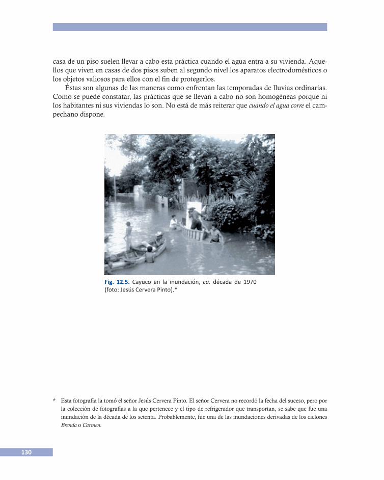
130
casa de un piso suelen llevar a cabo esta práctica cuando el agua entra a su vivienda. Aque-llos que viven en casas de dos pisos suben al segundo nivel los aparatos electrodomésticos o los objetos valiosos para ellos con el fin de protegerlos.
Éstas son algunas de las maneras como enfrentan las temporadas de lluvias ordinarias. Como se puede constatar, las prácticas que se llevan a cabo no son homogéneas porque ni los habitantes ni sus viviendas lo son. No está de más reiterar que cuando el agua corre el cam-pechano dispone.
* Esta fotografía la tomó el señor Jesús Cervera Pinto. El señor Cervera no recordó la fecha del suceso, pero por la colección de fotografías a la que pertenece y el tipo de refrigerador que transportan, se sabe que fue una inundación de la década de los setenta. Probablemente, fue una de las inundaciones derivadas de los ciclones Brenda o Carmen.
Fig. 12.5. Cayuco en la inundación, ca. década de 1970 (foto: Jesús Cervera Pinto).*
131
Referencias
Álvarez Suárez, Francisco 1991 Anales históricos de Campeche. Tomo I, Edición Facsimilar (1912), Mérida, Maldonado
Editores, (Colección San Francisco de Campeche). 1991 Anales históricos de Campeche. Tomo II, Edición Facsimilar (1913), Mérida Maldonado
Editores, (Colección San Francisco de Campeche).Báez Landa, Mariano 1990 Campeche. La otra puerta de México, México, Comisión Estatal Conmemorativa del V
Centenario del Encuentro de dos Mundos, Gobierno del estado de Veracruz, Colec-ción V Centenario.
Cuevas Portilla, Jimena 2010 Aquí no pasa nada. Estrategias y prácticas espaciales para hacer frente a fenómenos hidrometeo�
rológicos en la ciudad de San Francisco de Campeche, Tesis de maestría en Antropología Social, México, ciesas-df.
Harvey, David 2004 La condición de la posmodernidad. Investigación sobre los orígenes del cambio cultural, (Edi-
ción original en inglés 1990), Martha Eguía (trad.), Buenos Aires, Amorrortu.Lefebvre, Henri 1991 The production of space, (edición original en francés 1974), Donald Nicholson-Smith
(trad.), Londres, Blackwell, 1991.Periódico oficial del estado de Campeche 1910 “Reglamento de banquetas”, en Periódico Oficial del gobierno del estado libre y soberano de
Campeche, julio 19, Campeche, núm. 2094, Año. XXVIII, Sección Oficial, Primera pla-na, pp. 1-2.
Contacto Jimena Cuevas Portilla, ciesas/unam, México: <[email protected]>.

133
CASOS DE ÁFRICA DEL OESTE
WEST AFRICAN CASES

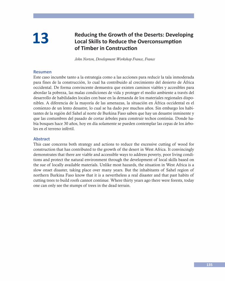
135
13 Reducing the Growth of the Deserts: Developing Local Skills to Reduce the Overconsumption
of Timber in Construction
John Norton, Development Workshop France, France
ResumenEste caso incumbe tanto a la estrategia como a las acciones para reducir la tala inmoderada para fines de la construcción, lo cual ha contribuido al crecimiento del desierto de África occidental. De forma convincente demuestra que existen caminos viables y accesibles para abordar la pobreza, las malas condiciones de vida y proteger el medio ambiente a través del desarrollo de habilidades locales con base en la demanda de los materiales regionales dispo-nibles. A diferencia de la mayoría de las amenazas, la situación en África occidental es el comienzo de un lento desastre, lo cual se ha dado por muchos años. Sin embargo los habi-tantes de la región del Sahel al norte de Burkina Faso saben que hay un desastre inminente y que las costumbres del pasado de cortar árboles para construir techos continúa. Donde ha-bía bosques hace 30 años, hoy en día solamente se pueden contemplar las cepas de los árbo-les en el terreno infértil.
AbstractThis case concerns both strategy and actions to reduce the excessive cutting of wood for construction that has contributed to the growth of the desert in West Africa. It convincingly demonstrates that there are viable and accessible ways to address poverty, poor living condi-tions and protect the natural environment through the development of local skills based on the sue of locally available materials. Unlike most hazards, the situation in West Africa is a slow onset disaster, taking place over many years. But the inhabitants of Sahel region of northern Burkina Faso know that it is a nevertheless a real disaster and that past habits of cutting trees to build roofs cannot continue. Where thirty years ago there were forests, today one can only see the stumps of trees in the dead terrain.
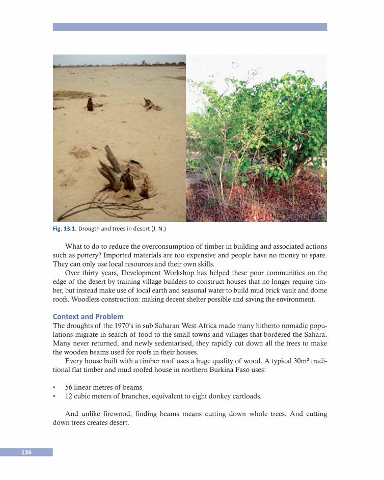
136
What to do to reduce the overconsumption of timber in building and associated actions such as pottery? Imported materials are too expensive and people have no money to spare. They can only use local resources and their own skills.
Over thirty years, Development Workshop has helped these poor communities on the edge of the desert by training village builders to construct houses that no longer require tim-ber, but instead make use of local earth and seasonal water to build mud brick vault and dome roofs. Woodless construction: making decent shelter possible and saving the environment.
Context and ProblemThe droughts of the 1970’s in sub Saharan West Africa made many hitherto nomadic popu-lations migrate in search of food to the small towns and villages that bordered the Sahara. Many never returned, and newly sedentarised, they rapidly cut down all the trees to make the wooden beams used for roofs in their houses.
Every house built with a timber roof uses a huge quality of wood. A typical 30m² tradi-tional flat timber and mud roofed house in northern Burkina Faso uses:
• 56 linear metres of beams• 12 cubic meters of branches, equivalent to eight donkey cartloads.
And unlike firewood, finding beams means cutting down whole trees. And cutting down trees creates desert.
Fig. 13.1. Drougth and trees in desert (J. N.)
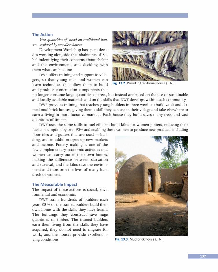
137
The ActionVast quantities of wood on traditional hou�
ses – replaced by woodless housesDevelopment Workshop has spent deca-
des working alongside the inhabitants of Sa-hel indentifying their concerns about shelter and the environment, and deciding with them what can be done.
dwf offers training and support to villa-gers, so that young men and women can learn techniques that allow them to build and produce construction components that no longer consume large quantities of trees, but instead are based on the use of sustainable and locally available materials and on the skills that dwf develops within each community.
dwf provides training that teaches young builders in three weeks to build vault and do-med mud brick houses, giving them a skill they can use in their village and take elsewhere to earn a living in more lucrative markets. Each house they build saves many trees and vast quantities of timber.
dwf uses the same skills to fuel efficient build kilns for women potters, reducing their fuel consumption by over 90% and enabling these women to produce new products including floor tiles and gutters that are used in buil-ding, and in addition open up new markets and income. Pottery making is one of the few complementary economic activities that women can carry out in their own homes, making the difference between starvation and survival, and the kilns save the environ-ment and transform the lives of many hun-dreds of women.
The Measurable ImpactThe impact of these actions is social, envi-ronmental and economic:
dwf trains hundreds of builders each year; 80 % of the trained builders build their own home with the skills they have learnt. The buildings they construct save huge quantities of timber. The trained builders earn their living from the skills they have acquired; they do not need to migrate for work; and the houses provide excellent li-ving conditions.
Fig. 13.2. Wood in traditional house (J. N.)
Fig. 13.3. Mud brick house (J. N.)
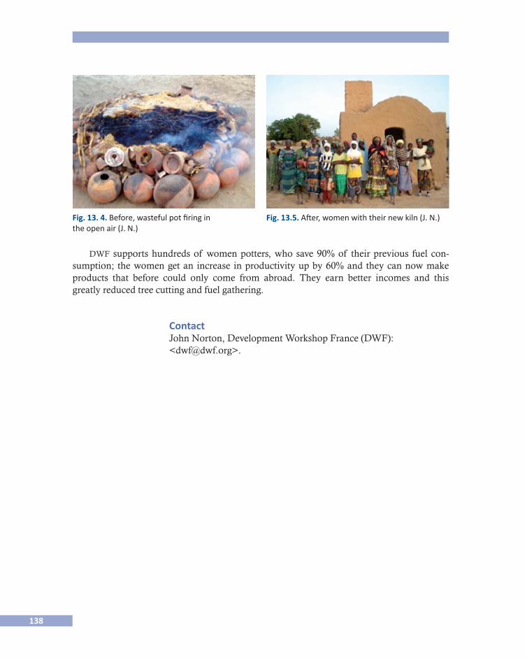
138
dwf supports hundreds of women potters, who save 90% of their previous fuel con-sumption; the women get an increase in productivity up by 60% and they can now make products that before could only come from abroad. They earn better incomes and this greatly reduced tree cutting and fuel gathering.
Contact John Norton, Development Workshop France (DWF): <[email protected]>.
Fig. 13. 4. Before, wasteful pot firing in the open air (J. N.)
Fig. 13.5. After, women with their new kiln (J. N.)
139
Sobre los autores
Audefroy, Joel F.Profesor investigador en la esia-Tecamachalco del Instituto Politécnico Nacional de Méxi-co, coordinador de la Maestría de Arquitectura y Urbanismo de la Sección de Posgrado, asesor de la Coalición Internacional para el Hábitat (hic-al), doctor en Etnología de la Universidad de Paris VII, arquitecto dplg de la Escuela Superior de Bellas Artes de París, Francia. Miembro de la Red cyted xiv-g “Hábitat en riesgo” y del Sistema Nacional de Investigadores. Trabaja en el tema de los asentamientos humanos en riesgo, Disaster risk re�duction (drr), y Reasentamiento posdesastre. Autor de varios libros y artículos de revistas indexadas en el campo del hábitat y del urbanismo.
Briones, FernandoDoctor en Antropología Social y Etnología por la École des Hautes Études en Sciences So-ciales (París, Francia). Actualmente es profesor-investigador en el Centro de Investigaciones y Estudios Superiores en Antropología Social (ciesas) en la ciudad de México. Su principal proyecto es Conocimiento del clima y adaptación: Una aproximación antropológica al cambio climá�tico en México. Ha trabajado en diferentes aspectos de las relaciones clima-sociedad, como la gestión del riesgo, los patrones de vulnerabilidad social y los traslados posteriores a un de-sastre en México y Brasil.
Cabrera Sánchez, Bertha NellyEs profesora de arquitectura en el Instituto Politécnico Nacional (ipn) México y profesora investigadora en el área de estudios de posgrado e investigación de la esia, Tecamachalco, del mismo ipn. Ha realizado estudios relacionados con la prevención de desastres hidrome-teorológicos. Obtuvo el grado de maestra en el ipn. Es co-autora de libros y capítulos en di-versas publicaciones dentro de su área de investigación que es el impacto causado por los fenómenos hidrometeorológicos.
Cadag, Jake Rom D.Es actualmente estudiante de doctorado en la Universidad Paul Valery en Montpellier, Francia. Fue miembro del departamento de Geografía de la Universidad de Filipinas. Está haciendo su especialidad en gestión de desastres relacionada con la etnicidad. Trabaja con las comunidades, enfocándose en el desarrollo de instrumentos participativos que involu-cren a las comunidades e integren a todos los interesados en la reducción del riesgo ante los desastres.

140
Cuevas Portilla, JimenaEs antropóloga social de la Escuela Nacional de Antropología e Historia (enah) de México. Obtuvo su maestría en antropología social en el Centro de Investigaciones y Estudios Supe-riores en Antropología Social (ciesas) en México. En los últimos años ha trabajado en in-vestigaciones sobre desastres en México, particularmente ha elaborado varios casos de estudio en los que ha destacado cómo ciertas sociedades han tratado de ser resilientes, redu-ciendo su vulnerabilidad social. En 2011 publicó el libro Aquí no pasa nada. Formas de actuar cotidianas para enfrentar el exceso de agua en la ciudad de Campeche, México, Saarbrücken, Edito-rial Académica Española.
Chantry, GuillaumeEs ingeniero civil. Estudió en la Escuela Nacional de Puentes y Caminos (enpc-París) y en el Instituto para el Estudio de Desarrollo Económico y Social (iedes-París). Urbanista (De-partamento de Vivienda y Urbanismo en Dakar-Senegal), planeador de la capital regional como ingeniero civil (Arquitecto Papatheodorou, París). Ha trabajado en programas de vi-vienda como ingeniero, director adjunto (Vivienda y Equipo de Construcción gret, París: Grupo de Investigación e Intercambios Tecnológicos). Ha llevado a cabo proyectos de Con-sultoría en Laos y Vietnam. Ha sido coordinador del Programa “Taller de reducción del riesgo de desastres con actividades en Vietnam y el Sudeste Asiático” desde 1999.
Francisco, Arturo Es coordinador del Programa de la Fundación para el Desarrollo Rural Integrado (irdf). Ha estado involucrado en la respuesta a desastres desde 1992, después de la erupción del Monte Pinatubo en las Filipinas. También ha asistido a seminarios y cursos de capacitación en gestión, reducción del riesgo de desastres y cambio climático, y ha realizado cursos de formación y orientación sobre la Reducción de Desastres y Gestión de Riesgos.
Gaillard, JC Es profesor en la Universidad de Auckland en Nueva Zelanda. Se formó como geógrafo con especial interés en la reducción del riesgo de desastres (rrd) en Asia y el Pacífico. Sus trabajos actuales están enfocados en el desarrollo de herramientas participativas para la rrd y en la participación de los grupos marginados en las actividades relacionadas con los desastres, con énfasis en el origen étnico, sexo, prisioneros y personas sin hogar. También trabaja en entrena-miento para mapeo participativo y rrd basado en la comunidad, particularmente en colabora-ción con organizaciones no gubernamentales, gobiernos locales y organizaciones comunitarias. Es editor de la revista Disaster Prevention and Management y se desempeñó como coeditor, junto a Ben Wisner e Ilan Kelman del Routledge Handbook of Hazards and Disaster Risk Reduction.
García Acosta, Virginia Es licenciada y maestra en antropología social y doctora en historia. Es investigadora del ciesas desde 1974. Es autora de más de una centena de artículos o capítulos y autora o coordinadora de 20 libros. Sus investigaciones se relacionan con la historia de la alimenta-
141
ción y del riesgo y los desastres desde una perspectiva histórico-antropológica. Sus intere-ses se relacionan con los temblores y los desastres agrícolas (huracanes, inundaciones, sequías, granizadas, etcétera). Ha dirigido o codirigido proyectos de investigación como “El Niño y la construcción social de riesgos en América Latina” (iai y la red), “Los hu-racanes en la historia de México: catálogo y memoria” (Conacyt). Es directora general del ciesas desde 2004, cargo que asumirá hasta el año 2014.
Glipo, Arze Es actualmente directora ejecutiva de la Fundación para el Desarrollo Rural Integrado (irdf), una organización no gubernamental sin fines de lucro en las Filipinas, involucrada en el empoderamiento de la población rural pobre mediante la promoción de políticas y la investigación, así como de la organización y desarrollo de la capacidad de las organizacio-nes locales. Es defensora de los enfoques participativos de reducción de riesgos. Fue miem-bro de la Junta Provincial Legislativa de Sorsogon, Filipinas, de 2004 a 2010.
Jakkila, Juho Es maestro en ciencias e hidrólogo en el Instituto Finlandés del Medio Ambiente. Publica-ciones: “2012 Finland’s water resources and climate change - Effects and adaptation”, Water Adapt Final report (colectivo y en proceso) y “Radiation transfer and heat budget during the ice season in Lake Pääjärvi, Finland”, en Aquatic Ecology (colectivo, 2009).
Menoni, Scira Es actualmente profesora asociada en el Politécnico de Milán, en el Departamento de Ar-quitectura y Planificación, donde imparte los siguientes cursos: Herramientas para la gestión de riesgos, Planificación de emergencias y aspectos cognitivos de la gestión de crisis en un programa internacional que ofrece el Politécnico: Ingeniería Civil para la Gestión de Riesgos. Tam-bién enseña en el cerg-c: Especialización certificada para la evaluación y gestión de riesgos relacio�nados con la geología y el clima en la Universidad de Ginebra, Suiza. Su campo de especialización es la prevención de riesgos tecnológicos y naturales, considerando en parti-cular las medidas no estructurales. En dicho campo da atención específica a la gestión, or-denamiento territorial y preparación para emergencias. Ha participado y ha coordinado investigaciones en el ámbito de los riesgos naturales.
Nguyen, Huong Tra Obtuvo la maestría en ingeniería, ingeniería ambiental y ordenamiento territorial, en el Poli-técnico de Milán en 2010, con una tesis sobre la posibilidad de introducir un seguro de ries-gos naturales en Vietnam. Obtuvo la licenciatura en ingeniería, ingeniería de tecnologías del medio ambiente, en 2006 en la Hanoi University of Technology. Ha estado trabajando como ingeniero ambiental y gerente de relaciones en sfc Vietnam Investment Development for Environment Corp. en 2008, y como ingeniero de proyectos del medio ambiente en seen Technologies Corporation entre 2007 y 2008. Actualmente es consultora en Live & Learn de Environmental Education.
142
Norton, John Maestro en arquitectura de la Architectural Association, Reino Unido. Miembro fundador del Development Workshop (1973) y presidente del Development Workshop France desde 1998. Su investigación y actividades se desarrollan en el campo de los asentamientos huma-nos y la Reducción de Riesgos de Desastre. Sus principales publicaciones son: “Atlas of house vulnerability & strengthening”, echo/jani/dwf, 2011; “Building with earth”, it Publications, 2a. edición,1997; “Woodless Construction. Unstabilised earth brick Vault and Dome Roofing without formwork”, de 1997 publicado por la Lund University, así como otros muchos artículos y capítulos acerca de la rrd.
Nurmi, Teemu Maestro en ciencias e hidrólogo del Instituto Finlandés del Medio Ambiente.
Pigeon, Patrick Es actualmente profesor de tiempo completo en la Universidad de Saboya, Francia. Fue res-ponsable de un grupo interdisciplinario de investigadores en la gestión de riesgos en el cnrs (Centre National de la Recherche Scientifique) entre 2005 y 2011. Ha publicado libros sobre estos temas: Géographie Critique des Risques (París, Economica-Anthropos, 2005) y L’Environnement au défi de l’Urbanisation (Presses Universitaires de Rennes, 2007). El próxi-mo será publicado en el año 2012: Catastrophes et Résiliences (Paris, L’Harmattan).
Quesada Avendaño, Florencia Licenciada y maestra en historia y doctora en estudios latinoamericanos. Investigadora y profesora en el Departamento de Estudios Políticos y Económicos de la Universidad de Helsinki. Ha publicado varios artículos y libros sobre historia urbano-cultural e historia de la arquitectura de Costa Rica. Actualmente es investigadora principal del proyecto: “Políti-cas y prácticas de la industria del turismo. Un estudio comparativo e interdisciplinario sobre América Central”. Su última publicación es “La Modernización entre cafetales. San José, Costa Rica, 1880-1930”, San José, Editorial de la Universidad de Costa Rica, 2011.
Vehviläinen, Bertel Cuenta con un PhD. Actualmente es hidrólogo-jefe del Instituto Finlandés del Medio Am-biente y profesor adjunto en la Universidad de Helsinki. Su campo de investigación es la hi-drología. Sus principales publicaciones son: “Snow cover models in operational watershed forecasting” (Helsinki, Publications of Water and Environment Research Institute, 1992) y “The effect of climate change on design floods of high hazard dams in Finland” en Hydrology Research, 2008.
Veijalainen, Noora Es estudiante del doctorado en el Instituto Finlandés del Medio Ambiente en el área de hi-drología. Su publicación más importante es: Veijalainen, N., E. Lotsari, P. Alho, B. Vehvi-

143
läinen, J. Käyhkö, “National scale assessment of climate change impacts on flooding in Finland”, Journal of Hydrology, 2010.
Warner, Jeroen Es profesor asistente en la Universidad de Wageningen, dentro del Grupo de Estudios sobre Desastres, donde también obtuvo su doctorado. Dirige un proyecto de investigación sobre la participación de múltiples actores interesados en la gestión del agua en cuatro continentes. Este proyecto dio lugar al volumen Multi�Stakeholder Platforms for Integrated Water Manage�ment que fue publicado en 2007 por Routledge y aquél titulado Conflictos y Participación, pu-blicado por Nordan en 2004 (con Alejandra Moreyra). En 2010 publicó Water Politics (Routledge) en coautoria con Kai Wegerich y en 2011 su tesis doctoral, Flood Planning (ib Tauris). Sus trabajos han aparecido en una gran variedad de revistas académicas, incluyen-do Political Geography, International Negotiation, Water International, Water Policy, Water Alter�natives, Agriculture and Human Values y Disasters, y es coeditor de la nueva Revista Internacional de Gobernabilidad del Agua.
144
BIO DATAS
Audefroy, Joel F. Senior Lecturer in the esia-Tecamachalco of the National Polytechnic Institute of Mexico, Coordinator of the Masters of Architecture and Urbanism of esia, Adviser of the Habitat International Coalition (hic-al), Doctor in Ethnology of the University of Paris VII, Ar-chitect dplg of the School ensba of Paris, France. Member of Network cyted xiv-g “Habitat at risk” and of the Mexican National System of Investigators. Topical research in-terest: human settlements at risk, Disaster risk reduction (drr), Post-disaster resettlement. Author of several books and papers in peer review in the field of the habitat and urbanism.
Briones, Fernando Holds a Ph.D. in Social Anthropology and Ethnology from École des Hautes Etudes en Sci-ences Sociales (Paris, France). Currently he is a Research profesor at Centro de Investigacio-nes y Estudios Superiores en Antropología Social (ciesas) in Mexico City. He has been working in different aspects about the society-climate relationships, as management of risk, social vulnerability patterns and post-disaster relocations in Mexico and Brazil.
Cabrera Sánchez, Bertha NellyProfessor of architecture at the National Polytechnic Institute. México. She is also research professor of the section of graduate studies and research on the esia Tecamachalco, and has worked in the studies related to prevention hydrometeorological disasters. She gained her MSc from the National Polytechnic Institute. She is co-author of books, and book chapters, her research interests are in the area of impacts caused for hydrometeorological phenomena.
Cadag, Jake Rom D. Is currently a PhD student at Paul Valery University in Montpellier, France. He is also a for-mer faculty member of the Department of Geography of the University of the Philippines. He is pursuing his professional specialties in disaster management in relation with ethnicity. He is an aspiring community worker focusing on the development of participatory tools that involve communities and integrate all potential stakeholders in disaster risk reduction.
Cuevas Portilla, Jimena Is a social anthropologist of the Escuela Nacional de Antropología e Historia (enah) of Mexico. She obtained her Master’s degree in social anthropology at the Centro de Investiga-ciones y Estudios Superiores en Antropología Social (ciesas) in Mexico. In the last years she has been working on disaster research in Mexico. Particularly she has developed some
145
case studies in which she highlighted how people try to be resilient reducing its social vul-nerability. On 2011 she published her book Aquí no pasa nada. Formas de actuar cotidianas para enfrentar el exceso de agua en la ciudad de Campeche, México, Saarbrücken, Editorial Académica Española.
Chantry, Guillaume Is a Civil Engineer. Studied at École Nationale des Ponts et Chaussées (enpc-Paris) and In-stitut d”Études de Développement Économique et Social (iedes-Paris). Town planner- Di-rection of Housing and Planning / Dakar- Senegal. Regional capital planning: Civil engineer - Papathéodorou Architect / Paris. Housing programmes: Engineer, Deputy Direc-tor - Housing and Construction Team gret / Paris (Group of Research and Technological Exchanges). Consultant Projects in Lao pdr and Vietnam. Programme coordinator, Devel-opment Workshop disaster risk reduction activities in Vietnam and se Asia since 1999.
Francisco, Arturo Is a program coordinator of the Integrated Rural Development Foundation (irdf). He has been involved in disaster response since 1992 after the Mt Pinatubo eruption in the Philip-pines. He also attended seminars and trainings in disaster risk reduction and management and climate change. He had also conducted trainings and orientation on Disaster Risk Re-duction and Management.
García Acosta, Virginia Is a social anthropologist (ba and Master) and historian (PhD), and a researcher since 1974 in ciesas (Center for Research and Advanced Studies in Social Anthropology) at Mexico City. She is author or coordinator of more than 100 articles and 20 books. Her research re-lates to food history and to disaster and risk from a historical-anthropological perspective. Her interests are around earthquakes and agricultural disasters (hurricanes, floods, droughts, hailstorms and so on) in Mexican and Latin American history. Has been PI or Co-PI in sev-eral research projects: “El Niño and the social construction of risks in Latin America” (iai & la red), “Hurricanes in Mexican History; Memory and Catalogue” (Conacyt). She has been ciesas General Director since 2004, commission that will expire in 2014.
Gaillard, JC Is senior lecturer at The University of Auckland in New Zealand. He trained as a geogra-pher with particular interest in disaster risk reduction (drr) in Asia and the Pacific. His present works focus on developing participatory tools for drr and in involving marginalised groups in disaster-related activities with an emphasis on ethnicity, gender, prisoners and homeless people. JC Gaillard also collaborates to participatory mapping and community-based drr trainings with ngo, local governments and community-based organisations. He is an editor of the journal Disaster Prevention and Management and served as co-editor, with Ben Wisner and Ilan Kelman, for the Routledge Handbook of Hazards and Disaster Risk Reduction.
146
Glipo, Arze Is currently the Executive Director of the Integrated Rural Development Foundation (irdf), a non-profit ngo in the Philippines engaged in empowering the rural poor through policy advocacy and research, organizing and capacity building of local organizations. Ms. Glipo advocates among others participatory disaster risk reduction approaches. She was a member of the Provincial Legislative Board of Sorsogon, Philippines, from 2004-2010.
Jakkila, Juho M.Sc. is a hydrologist at the Finnish Environment Institute. Publications: Noora Veijalain-en, Juho Jakkila, Teemu Nurmi, Bertel Vehviläinen, Mika Marttunen and Juha Aaltonen (2012) Finland’s water resources and climate change - Effects and adaptation, WaterAdapt Final report. (In Finnish) and Jakkila J, Leppäranta M, Kawamura T, Shirasawa K, and Sa-lonen K (2009) “Radiation transfer and heat budget during the ice season in Lake Pääjärvi, Finland”, Aquatic Ecology.
Menoni, Scira Is presently an associate professor at the Politecnico of Milan, Dipartimento Architettura e Pianificazione, teaching the following courses: Tools for risk management, Emergency planning and Cognitive aspects of crisis management at an international program offered by the Politec-nico, Civil Engineering for Risk Management. She also teaches at the cerg-c Specialisation certificate for the assessment and management of geological and climate related risk at the Geneva University, Switzerland. Field of specialization technological and natural risks prevention, looking particularly at non-structural measures. Among the latter, a specific stress is given to land use planning and emergency preparedness and management. She has been involved and has coordinated EU funded research in the field of natural hazards.
Nguyen, Huong Tra Got her Master of Engineering, Environmental and Land Planning Engineering, at the Po-litecnico di Milano in 2010, developing a thesis on the possibility to introduce natural haz-ards insurance in Vietnam; she got her Bachelor of Engineering, Environmental Technologies Engineering, in 2006 at the Hanoi University of Technology. She has been working as an Environmental Engineer and Relation Manager at SFC Vietnam Investment Development for Environment Corp for 7 months in 2008; and as an Environmental Project Engineer at seen Technologies Corporation between February 2007 and February 2008. Currently she is a Consultant at Live & Learn Environmental Education.
Norton, John MA in Architecture from Architectural Association, UK. Founder member of Development Workshop (1973) & President of Development Workshop France since 1998. Research and activities in the field of Human Settlements and Disaster Risk Reduction. Main publica-tions: “Atlas of house vulnerability & strengthening”, echo/jani/dwf July 2011; “Build-ing with earth”. IT Publications 2nd Edition1997; “Woodless Construction. Unstabilised
147
earth brick Vault and Dome Roofing without formwork” Lund University 1997, and many articles and chapters on disaster risk reduction.
Nurmi, TeemuM.Sc. Is a hydrologist at the Finnish Environment Institute.
Pigeon, Patrick Is currently full-time professor at Université de Savoie (France). He has been responsible for an interdisciplinary group of searchers on risk management at french cnrs (Centre nation-al de la recherche scientifique) between 2005 and 2011. He published books on these issues, such as Géographie critique des risques (Paris, Economica-Anthropos, 2005) or L’environnement au défi de l’urbanisation (Presses universitaires de Rennes, 2007). The next one will be pub-lished in 2012: Catastrophes et Résiliences, Paris L’Harmattan.
Quesada Avendaño, FlorenciaHistory (BA and Master), Latin American Studies (PhD), she is a researcher and lecturer at the Department of Political and Economic Studies at the University of Helsinki. She has published several articles and books about the urban cultural and architectural history in Costa Rica. Currently she is the main researcher on the project: Policies and practices of tourism industry. A comparative and interdisciplinary study on Central America. Her last publication: F. Quesada Avendaño, “La Modernización entre cafetales. San José, Costa Rica 1880- 1930”, San José: Editorial de la Universidad de Costa Rica, 2011.
Vehviläinen, BertelPhD. is a chief hydrologist at the Finnish Environment Institute and an adjunct professor at the University of Helsinki. Research field Hydrology. Main publication: Vehviläinen, B. 1992. Snow cover models in operational watershed forecasting. Publications of Water and Environment Research Institute 11. Helsinki and Veijalainen, N. and Vehviläinen, B. 2008, The effect of climate change on design floods of high hazard dams in Finland, Hydrology Research.
Veijalainen, NooraIs a PhD student at the Finnish Environment Institute in the field of Hydrology. Main publi-cation: Veijalainen, N., Lotsari E., Alho, P., Vehviläinen, B., Käyhkö, J. 2010. National scale assessment of climate change impacts on flooding in Finland. Journal of Hydrology.
Warner, Jeroen Is assistant professor at Wageningen University’s Disaster Studies group, where he also gained his PhD. Warner directed a research project on multi-stakeholder participation in water management in four continents. This project led to the co-edited volume, Multi-Stake-holder Platforms for Integrated Water Management that was published in 2007 by Rout-ledge and the book Conflictos y Participación published by Nordan in 2004 (with Alejandra
148
Moreyra). In 2010 he published the book “Water Politics” with Routledge (co-authored with Kai Wegerich) and in 2011 his dissertation, Flood Planning, with IB Tauris. Warner pub-lished in a variety of academic journals, including Political Geography, International Nego-tiation, Water International, Water Policy, Water Alternatives, Agriculture and Human Values and Disasters and is co-editor of the new International Journal of Water Governance.
Estrategias sociales de prevención y adaptación /Social Strategies for Prevention and Adaptation
se terminó de imprimir en noviembre de 2012,en los talleres de Ediciones del Lirio,
Azucenas 10, San Juan Xalpa, Iztapalapa,09850, México D.F.
El tiraje consta de 500 ejemplares.